Bridge Statistics for Grand Blanc, Michigan (MI)
Condition, Traffic, Stress, Structural Evaluation, Project Costs
- National Bridge Inventory (NBI) Statistics
- 30Number of bridges
- 233ft / 71.2mTotal length
- $1,003,000Total costs
- 472,579Total average daily traffic
- 37,133Total average daily truck traffic
- National Bridge Inventory (NBI) Registered Bridges for Grand Blanc
- No street view available for this location
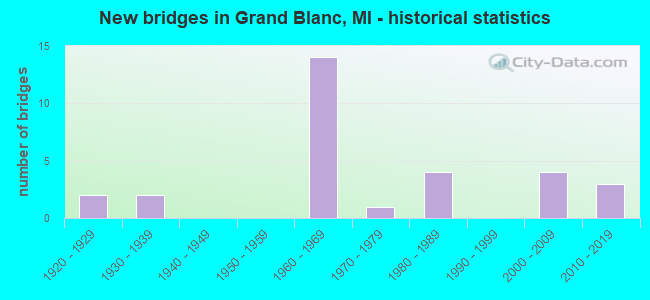
- New bridges - historical statistics
- 21920-1929
- 21930-1939
- 141960-1969
- 11970-1979
- 41980-1989
- 42000-2009
- 32010-2019

- Reconstructed bridges - Historical Statistics
- 11980-1989
- 31990-1999


- Bridge Condition - Deck
- 6.7%Excellent
- 13.3%Very good
- 33.3%Good
- 33.3%Satisfactory
- 13.3%Fair

- Bridge Condition - Superstructure
- 6.3%Excellent
- 31.3%Very good
- 12.5%Good
- 18.8%Satisfactory
- 25.0%Fair
- 6.3%Poor

- Bridge Condition - Substructure
- 6.3%Excellent
- 37.5%Very good
- 12.5%Good
- 25.0%Satisfactory
- 12.5%Fair
- 6.3%Serious

- Bridge Condition - Channel
- 30.8%Very good
- 30.8%Good
- 15.4%Satisfactory
- 15.4%Fair
- 7.7%Poor

- Bridge Condition - Culverts
- 25.0%Good
- 75.0%Satisfactory
Find on map >> Show street view
Structure Number: 137, Location: 2.3 MI NW OF ALLEGAN (Lat: 42.545125, Lng: -85.878481), Route carried "on" structure: State highway 40, Year Built: 1938, Year Reconstructed: 1995, Status: Open, Structure Length: 6.86m (22.51ft), Average Daily Traffic: 8,300 (year 2013), Truck Traffic: 7%, Average Future Daily Traffic: 12,263 (year 2018), Design Load: HS 25 or greater, Features Intersected: KALAMAZOO RIVER
Minimum Vertical Clearance: 30.48m (100.00ft), Kilometerpoint: 3.677, Lanes on structure: 2, Base Highway Network: Yes (Inventory Route: 78, Subroute: 9), Owner: State Highway Agency, Approaching Roadway Width: 11.1m (36.4ft), Navigation Control: Yes ( Vertical Clearance: 0.3m (1.0ft), Horizontal Clearance: 5.4m (17.7ft)), Material/Design: Prestressed concrete, Design/Construction: Stringer/Multi-beam, Number Of Spans In Main Unit: 5, Length of Maximum Span: 13.7m (44.9ft), Curb-To-Curb Width: 13.4m (44.0ft), Out-to-Out Width: 14.3m (46.9ft)
Condition: Deck: Good, Superstructure: Good, Substructure: Serious, Channel: Good, Operating Rating: 66.4 metric tons, Method Used To Determine Operating Rating: Load Factor (LF) rating reported by rating factor (RF) method using MS18 loading, Inventory Rating: 35.6 metric tons, Method Used To Determine Inventory Rating: Load Factor (LF) rating reported by rating factor (RF) method using MS18 loading, Structural Evaluation: High priority of corrective action, Deck Geometry: Equal to present minimum criteria, Waterway Adequacy: Equal to present desirable criteria, Approach Roadway Alignment: Equal to present minimum criteria, Designated Inspection Frequency: Every 12 months, Underwater Inspection Frequency: Every 60 months, Inspection Date: July 2021, Underwater Inspection Date: June 2017, Deck Structure Type: Concrete Cast-file-Place, Wearing Surface/Protective System: Wearing Surface: Epoxy Overlay, Deck Protection: Epoxy Coated Reinforcing
Find on map >> Show street view
Structure Number: 1364, Location: 3 1/2 MI E OF HOMER (Lat: 42.137592, Lng: -84.743917), Route carried "on" structure: County highway , Year Built: 2018, Status: Open, Structure Length: 1.58m (5.18ft), Average Daily Traffic: 117 (year 2018), Truck Traffic: 2%, Average Future Daily Traffic: 173 (year 2038), Design Load: Greater than HL93, Features Intersected: S BRANCH KALAMAZOO RIVER, Facility Carried by Structure: 28.5 MILE ROAD
Minimum Vertical Clearance: 30.48m (100.00ft), Kilometerpoint: 0.927, Lanes on structure: 2, Owner: County Highway Agency, Approaching Roadway Width: 8.5m (27.9ft), Material/Design: Prestressed concrete, Design/Construction: Box Beam or Girders - Multiple, Number Of Spans In Main Unit: 1, Length of Maximum Span: 15.5m (50.9ft), Curb-To-Curb Width: 8.7m (28.5ft), Out-to-Out Width: 9.7m (31.8ft)
Condition: Deck: Very good, Superstructure: Very good, Substructure: Very good, Channel: Good, Operating Rating: 81.3 metric tons, Method Used To Determine Operating Rating: Load and Resistance Factor Rating (LRFR) rating reported by rating factor(RF) method using HL-93 loadings, Inventory Rating: 62.5 metric tons, Method Used To Determine Inventory Rating: Load and Resistance Factor Rating (LRFR) rating reported by rating factor(RF) method using HL-93 loadings, Structural Evaluation: Equal to present desirable criteria, Deck Geometry: Equal to present minimum criteria, Waterway Adequacy: Equal to present desirable criteria, Approach Roadway Alignment: Equal to present desirable criteria, Length Of Structure Improvement: 1.89m (6.20ft), Designated Inspection Frequency: Every 24 months, Inspection Date: January 2021, Bridge Improvement Cost: $173,000, Roadway Improvement Cost: $95,000, Total Project Cost: $268,000, Deck Structure Type: Concrete Cast-file-Place, Wearing Surface/Protective System: Wearing Surface: Monolithic Concrete, Deck Protection: Epoxy Coated Reinforcing
Find on map >> Show street view
Structure Number: 1368, Location: 7 MI N OF MARSHALL (Lat: 42.373667, Lng: -84.917342), Route carried "on" structure: County highway , Year Built: 1974, Status: Posted for load, Structure Length: 1.46m (4.79ft), Average Daily Traffic: 147 (year 1994), Truck Traffic: 5%, Average Future Daily Traffic: 274 (year 2024), Design Load: HS 20+Mod, Features Intersected: STATE DITCH, Facility Carried by Structure: 19 1/2 MILE ROAD
Minimum Vertical Clearance: 30.48m (100.00ft), Kilometerpoint: 10.400, Lanes on structure: 2, Owner: County Highway Agency, Approaching Roadway Width: 7.6m (24.9ft), Material/Design: Wood or Timber, Design/Construction: Slab, Number Of Spans In Main Unit: 2, Length of Maximum Span: 7.3m (24.0ft), Curb-To-Curb Width: 8.6m (28.2ft), Out-to-Out Width: 9.0m (29.5ft)
Condition: Deck: Fair, Superstructure: Fair, Substructure: Fair, Channel: Satisfactory, Operating Rating: 43.7 metric tons, Method Used To Determine Operating Rating: Allowable Stress (AS) rating reported by rating factor (RF) method using MS18 loading, Inventory Rating: 31.1 metric tons, Method Used To Determine Inventory Rating: Allowable Stress (AS) rating reported by rating factor (RF) method using MS18 loading, Structural Evaluation: Somewhat better than minimum adequacy, Deck Geometry: Equal to present minimum criteria, Waterway Adequacy: Equal to present desirable criteria, Approach Roadway Alignment: Equal to present desirable criteria, Bridge Posting: Required (Relationship of Operating Rating to Maximum Legal Load: 30.0 - 39.9% below), Length Of Structure Improvement: 2.07m (6.79ft), Designated Inspection Frequency: Every 12 months, Inspection Date: September 2021, Deck Structure Type: Wood or Timber, Wearing Surface/Protective System: Wearing Surface: Bituminous, Deck Protection: Other
Find on map >> Show street view
Structure Number: 2402, Location: 1 MI W OF EATON RAPIDS (Lat: 42.497850, Lng: -84.679719), Route carried "on" structure: County highway , Year Built: 2017, Status: Open, Structure Length: 1.55m (5.09ft), Average Daily Traffic: 607 (year 2016), Truck Traffic: 2%, Average Future Daily Traffic: 700 (year 2036), Design Load: Greater than HL93, Features Intersected: SPRING BROOK, Facility Carried by Structure: WHITTUM ROAD
Minimum Vertical Clearance: 30.48m (100.00ft), Kilometerpoint: 0.381, Lanes on structure: 2, Owner: County Highway Agency, Approaching Roadway Width: 10.4m (34.1ft), Skew: 1 degrees, Material/Design: Prestressed concrete, Design/Construction: Box Beam or Girders - Single/Spread, Number Of Spans In Main Unit: 1, Length of Maximum Span: 14.8m (48.6ft), Curb-To-Curb Width: 10.4m (34.1ft), Out-to-Out Width: 11.4m (37.4ft)
Condition: Deck: Very good, Superstructure: Very good, Substructure: Very good, Channel: Very good, Operating Rating: 87.8 metric tons, Method Used To Determine Operating Rating: Load and Resistance Factor Rating (LRFR) rating reported by rating factor(RF) method using HL-93 loadings, Inventory Rating: 66.4 metric tons, Method Used To Determine Inventory Rating: Load and Resistance Factor Rating (LRFR) rating reported by rating factor(RF) method using HL-93 loadings, Structural Evaluation: Equal to present desirable criteria, Deck Geometry: Equal to present minimum criteria, Waterway Adequacy: Equal to present desirable criteria, Approach Roadway Alignment: Equal to present desirable criteria, Designated Inspection Frequency: Every 24 months, Inspection Date: June 2021, Deck Structure Type: Concrete Cast-file-Place, Wearing Surface/Protective System: Wearing Surface: Monolithic Concrete, Deck Protection: Epoxy Coated Reinforcing
Find on map >> Show street view
Structure Number: 2623, Location: 1.8 MI NW OF OAKLAND COL (Lat: 42.893128, Lng: -83.628503), Route carried "on" structure: Interstate 75, Year Built: 1962, Year Reconstructed: 2004, Status: Open, Structure Length: 7.07m (23.20ft), Average Daily Traffic: 21,217 (year 2007), Truck Traffic: 12%, Average Future Daily Traffic: 27,465 (year 2018), Design Load: HS 20, Features Intersected: CSX RR
Minimum Vertical Clearance: 30.48m (100.00ft), Kilometerpoint: 3.528, Lanes on structure: 3, Base Highway Network: Yes (Inventory Route: 149, Subroute: 4), Owner: State Highway Agency, Approaching Roadway Width: 15.5m (50.9ft), Skew: 14 degrees, Material/Design: Steel, Design/Construction: Stringer/Multi-beam, Number Of Spans In Main Unit: 3, Length of Maximum Span: 28.3m (92.8ft), Curb-To-Curb Width: 13.1m (43.0ft), Out-to-Out Width: 14.6m (47.9ft)
Condition: Deck: Satisfactory, Superstructure: Fair, Substructure: Good, Operating Rating: 64.2 metric tons, Method Used To Determine Operating Rating: Load Factor (LF) rating reported by rating factor (RF) method using MS18 loading, Inventory Rating: 38.6 metric tons, Method Used To Determine Inventory Rating: Load Factor (LF) rating reported by rating factor (RF) method using MS18 loading, Structural Evaluation: Somewhat better than minimum adequacy, Deck Geometry: Meets minimum limits, Approach Roadway Alignment: Equal to present desirable criteria, Designated Inspection Frequency: Every 13 months, Inspection Date: May 2021, Bridge Improvement Cost: $229,000, Roadway Improvement Cost: $11,000, Total Project Cost: $134,000, Deck Structure Type: Concrete Cast-file-Place, Wearing Surface/Protective System: Wearing Surface: Latex Concrete
Find on map >> Show street view
Structure Number: 2624, Location: 1.8 MI NW OF OAKLAND COL (Lat: 42.892783, Lng: -83.628494), Route carried "on" structure: Interstate 75, Year Built: 1962, Year Reconstructed: 2004, Status: Open, Structure Length: 7.07m (23.20ft), Average Daily Traffic: 21,217 (year 2007), Truck Traffic: 12%, Average Future Daily Traffic: 27,465 (year 2018), Design Load: HS 20, Features Intersected: CSX RR
Minimum Vertical Clearance: 30.48m (100.00ft), Kilometerpoint: 3.341, Lanes on structure: 3, Base Highway Network: Yes (Inventory Route: 150, Subroute: 7), Owner: State Highway Agency, Approaching Roadway Width: 18.9m (62.0ft), Skew: 14 degrees, Material/Design: Steel, Design/Construction: Stringer/Multi-beam, Number Of Spans In Main Unit: 3, Length of Maximum Span: 28.3m (92.8ft), Curb-To-Curb Width: 15.2m (49.9ft), Out-to-Out Width: 16.4m (53.8ft)
Condition: Deck: Satisfactory, Superstructure: Fair, Substructure: Good, Operating Rating: 91.0 metric tons, Method Used To Determine Operating Rating: Load Factor (LF) rating reported by rating factor (RF) method using MS18 loading, Inventory Rating: 54.4 metric tons, Method Used To Determine Inventory Rating: Load Factor (LF) rating reported by rating factor (RF) method using MS18 loading, Structural Evaluation: Somewhat better than minimum adequacy, Deck Geometry: Meets minimum limits, Approach Roadway Alignment: Equal to present desirable criteria, Designated Inspection Frequency: Every 13 months, Inspection Date: May 2021, Bridge Improvement Cost: $229,000, Roadway Improvement Cost: $46,000, Total Project Cost: $540,000, Deck Structure Type: Concrete Cast-file-Place, Wearing Surface/Protective System: Wearing Surface: Latex Concrete
Find on map >> Show street view
Structure Number: 263, Location: 3.0 MI SE OF US-23 (Lat: 42.915119, Lng: -83.672911), Route carried "on" structure: County highway 2002, Year Built: 1962, Year Reconstructed: 1980, Status: Open, Structure Length: 9.49m (31.14ft), Average Daily Traffic: 13,000 (year 2013), Truck Traffic: 3%, Average Future Daily Traffic: 19,000 (year 2016), Design Load: HS 20+Mod, Features Intersected: I-75, Facility Carried by Structure: GRAND BLANC RD
Minimum Vertical Clearance: 30.48m (100.00ft), Kilometerpoint: 20.876, Lanes on structure: 2, Lanes under structure: 6, Owner: State Highway Agency, Approaching Roadway Width: 15.2m (49.9ft), Skew: 4 degrees, Material/Design: Steel, Design/Construction: Stringer/Multi-beam, Number Of Spans In Main Unit: 4, Length of Maximum Span: 32.3m (106.0ft), Curb-To-Curb Width: 15.5m (50.9ft), Out-to-Out Width: 16.7m (54.8ft)
Condition: Deck: Fair, Superstructure: Fair, Substructure: Satisfactory, Operating Rating: 56.1 metric tons, Method Used To Determine Operating Rating: Load Factor (LF) rating reported by rating factor (RF) method using MS18 loading, Inventory Rating: 33.7 metric tons, Method Used To Determine Inventory Rating: Load Factor (LF) rating reported by rating factor (RF) method using MS18 loading, Structural Evaluation: Somewhat better than minimum adequacy, Deck Geometry: Superior to present desirable criteria, Underclear: Meets minimum limits, Approach Roadway Alignment: Equal to present desirable criteria, Designated Inspection Frequency: Every 24 months, Inspection Date: March 2022, Bridge Improvement Cost: $378,000, Deck Structure Type: Concrete Cast-file-Place, Wearing Surface/Protective System: Wearing Surface: Epoxy Overlay
Find on map >> Show street view
Structure Number: 2634, Location: 2.0 MI SW OF GRAND BLANC (Lat: 42.905700, Lng: -83.650892), Route carried "on" structure: State highway 54, Year Built: 1985, Status: Open, Structure Length: 5.36m (17.59ft), Average Daily Traffic: 13,232 (year 2007), Truck Traffic: 7%, Average Future Daily Traffic: 14,557 (year 2018), Design Load: HS 25 or greater, Features Intersected: I-75 SB
Minimum Vertical Clearance: 30.48m (100.00ft), Kilometerpoint: 0.158, Lanes on structure: 3, Lanes under structure: 3, Base Highway Network: Yes (Inventory Route: 149, Subroute: 8), Owner: State Highway Agency, Approaching Roadway Width: 15.8m (51.8ft), Material/Design: Steel, Design/Construction: Stringer/Multi-beam, Number Of Spans In Main Unit: 3, Length of Maximum Span: 32.0m (105.0ft), Curb-To-Curb Width: 17.0m (55.8ft), Out-to-Out Width: 18.0m (59.1ft)
Condition: Deck: Good, Superstructure: Satisfactory, Substructure: Satisfactory, Operating Rating: 71.3 metric tons, Method Used To Determine Operating Rating: Load Factor (LF) rating reported by rating factor (RF) method using MS18 loading, Inventory Rating: 42.8 metric tons, Method Used To Determine Inventory Rating: Load Factor (LF) rating reported by rating factor (RF) method using MS18 loading, Structural Evaluation: Equal to present minimum criteria, Deck Geometry: Superior to present desirable criteria, Underclear: Somewhat better than minimum adequacy, Approach Roadway Alignment: Equal to present desirable criteria, Designated Inspection Frequency: Every 13 months, Inspection Date: May 2021, Deck Structure Type: Concrete Cast-file-Place, Wearing Surface/Protective System: Wearing Surface: Monolithic Concrete, Deck Protection: Epoxy Coated Reinforcing
Find on map >> Show street view
Structure Number: 2635, Location: 2.0 MI SW OF GRAND BLANC (Lat: 42.906808, Lng: -83.649797), Route carried "on" structure: State highway 54, Year Built: 1985, Status: Open, Structure Length: 5.70m (18.70ft), Average Daily Traffic: 13,232 (year 2007), Truck Traffic: 7%, Average Future Daily Traffic: 14,557 (year 2018), Design Load: HS 25 or greater, Features Intersected: I-75 NB
Minimum Vertical Clearance: 30.48m (100.00ft), Kilometerpoint: 0.309, Lanes on structure: 3, Lanes under structure: 3, Base Highway Network: Yes (Inventory Route: 149, Subroute: 8), Owner: State Highway Agency, Approaching Roadway Width: 15.8m (51.8ft), Material/Design: Steel, Design/Construction: Stringer/Multi-beam, Number Of Spans In Main Unit: 3, Length of Maximum Span: 33.8m (110.9ft), Curb-To-Curb Width: 17.0m (55.8ft), Out-to-Out Width: 18.0m (59.1ft)
Condition: Deck: Satisfactory, Superstructure: Satisfactory, Substructure: Satisfactory, Operating Rating: 71.6 metric tons, Method Used To Determine Operating Rating: Load Factor (LF) rating reported by rating factor (RF) method using MS18 loading, Inventory Rating: 43.1 metric tons, Method Used To Determine Inventory Rating: Load Factor (LF) rating reported by rating factor (RF) method using MS18 loading, Structural Evaluation: Equal to present minimum criteria, Deck Geometry: Superior to present desirable criteria, Underclear: Somewhat better than minimum adequacy, Approach Roadway Alignment: Equal to present desirable criteria, Designated Inspection Frequency: Every 13 months, Inspection Date: May 2021, Deck Structure Type: Concrete Cast-file-Place, Wearing Surface/Protective System: Wearing Surface: Monolithic Concrete, Deck Protection: Epoxy Coated Reinforcing
Find on map >> Show street view
Structure Number: 2705, Location: 600 FT EAST OF HOLLY ROAD (Lat: 42.886919, Lng: -83.627661), Route carried "on" structure: County highway 2002, Year Built: 2007, Status: Open, Structure Length: 2.04m (6.69ft), Average Daily Traffic: 11,687 (year 2018), Truck Traffic: 8%, Average Future Daily Traffic: 21,108 (year 2038), Design Load: HS 20, Features Intersected: C & O RR (PERE MARQUETTE, Facility Carried by Structure: BALDWIN ROAD
Minimum Vertical Clearance: 30.48m (100.00ft), Kilometerpoint: 24.503, Lanes on structure: 5, Owner: County Highway Agency, Approaching Roadway Width: 18.3m (60.0ft), Skew: 1 degrees, Material/Design: Prestressed concrete, Design/Construction: Box Beam or Girders - Multiple, Number Of Spans In Main Unit: 1, Length of Maximum Span: 18.6m (61.0ft), Curb or Sidewalk Widths: Left: 0.0m, Right: 4.7m (15.4ft), Curb-To-Curb Width: 19.8m (65.0ft), Out-to-Out Width: 25.8m (84.6ft)
Condition: Deck: Good, Superstructure: Very good, Substructure: Very good, Operating Rating: 83.6 metric tons, Method Used To Determine Operating Rating: Load Factor (LF) rating reported by rating factor (RF) method using MS18 loading, Inventory Rating: 49.2 metric tons, Method Used To Determine Inventory Rating: Load Factor (LF) rating reported by rating factor (RF) method using MS18 loading, Structural Evaluation: Equal to present desirable criteria, Deck Geometry: Meets minimum limits, Approach Roadway Alignment: Equal to present desirable criteria, Designated Inspection Frequency: Every 24 months, Inspection Date: October 2020, Deck Structure Type: Concrete Cast-file-Place, Wearing Surface/Protective System: Wearing Surface: Monolithic Concrete, Deck Protection: Epoxy Coated Reinforcing
Find on map >> Show street view
Structure Number: 271, Location: INTERS OF PERRY & VASSAR (Lat: 42.932692, Lng: -83.573764), Route carried "on" structure: County highway 2534, Year Built: 2011, Status: Open, Structure Length: 1.98m (6.50ft), Average Daily Traffic: 7,228 (year 2005), Truck Traffic: 5%, Average Future Daily Traffic: 13,055 (year 2026), Design Load: Greater than HL93, Features Intersected: THREAD RIVER, Facility Carried by Structure: PERRY ROAD
Minimum Vertical Clearance: 30.48m (100.00ft), Kilometerpoint: 4.473, Lanes on structure: 2, Owner: County Highway Agency, Approaching Roadway Width: 6.1m (20.0ft), Skew: 3 degrees, Material/Design: Prestressed concrete, Design/Construction: Box Beam or Girders - Multiple, Number Of Spans In Main Unit: 1, Length of Maximum Span: 19.4m (63.6ft), Curb-To-Curb Width: 12.4m (40.7ft), Out-to-Out Width: 13.4m (44.0ft)
Condition: Deck: Good, Superstructure: Very good, Substructure: Very good, Channel: Very good, Operating Rating: 82.6 metric tons, Method Used To Determine Operating Rating: Load and Resistance Factor Rating (LRFR) rating reported by rating factor(RF) method using HL-93 loadings, Inventory Rating: 63.8 metric tons, Method Used To Determine Inventory Rating: Load and Resistance Factor Rating (LRFR) rating reported by rating factor(RF) method using HL-93 loadings, Structural Evaluation: Equal to present desirable criteria, Deck Geometry: Somewhat better than minimum adequacy, Waterway Adequacy: Equal to present desirable criteria, Approach Roadway Alignment: Equal to present desirable criteria, Designated Inspection Frequency: Every 24 months, Inspection Date: October 2020, Deck Structure Type: Concrete Cast-file-Place
Find on map >> Show street view
Structure Number: 2747, Location: BET HILL & SAGINAW ROAD (Lat: 42.939153, Lng: -83.632372), Route carried "on" structure: County highway 2002, Year Built: 1928, Status: Posted for load, Structure Length: 1.37m (4.49ft), Average Daily Traffic: 7,716 (year 2018), Truck Traffic: 5%, Average Future Daily Traffic: 13,936 (year 2038), Design Load: HS 20+Mod, Features Intersected: THREAD RIVER, Facility Carried by Structure: CENTER ROAD
Minimum Vertical Clearance: 30.48m (100.00ft), Kilometerpoint: 1.011, Lanes on structure: 2, Owner: County Highway Agency, Approaching Roadway Width: 11.9m (39.0ft), Material/Design: Steel, Design/Construction: Stringer/Multi-beam, Number Of Spans In Main Unit: 1, Length of Maximum Span: 12.8m (42.0ft), Curb-To-Curb Width: 9.1m (29.9ft), Out-to-Out Width: 10.8m (35.4ft)
Condition: Deck: Satisfactory, Superstructure: Poor, Substructure: Fair, Channel: Fair, Operating Rating: 30.1 metric tons, Method Used To Determine Operating Rating: Load Factor (LF) rating reported by rating factor (RF) method using MS18 loading, Inventory Rating: 18.1 metric tons, Method Used To Determine Inventory Rating: Load Factor (LF) rating reported by rating factor (RF) method using MS18 loading, Structural Evaluation: Meets minimum limits, Deck Geometry: High priority of corrective action, Waterway Adequacy: Equal to present desirable criteria, Approach Roadway Alignment: Equal to present desirable criteria, Bridge Posting: Required (Relationship of Operating Rating to Maximum Legal Load: > 39.9% below), Designated Inspection Frequency: Every 8 months, Inspection Date: Febuary 2022, Deck Structure Type: Concrete Cast-file-Place, Wearing Surface/Protective System: Wearing Surface: Bituminous
Find on map >> Show street view
Structure Number: 275, Location: BET PERRY & HILL ROAD (Lat: 42.935836, Lng: -83.597325), Route carried "on" structure: County highway 2002, Year Built: 1928, Year Reconstructed: 2021, Status: Open, Structure Length: 0.94m (3.08ft), Average Daily Traffic: 7,162 (year 2020), Truck Traffic: 8%, Average Future Daily Traffic: 10,643 (year 2040), Design Load: Greater than HL93, Features Intersected: THREAD RIVER, Facility Carried by Structure: BELSAY ROAD
Minimum Vertical Clearance: 30.48m (100.00ft), Kilometerpoint: 0.911, Lanes on structure: 2, Owner: County Highway Agency, Approaching Roadway Width: 8.5m (27.9ft), Material/Design: Prestressed concrete, Design/Construction: Box Beam or Girders - Single/Spread, Number Of Spans In Main Unit: 1, Length of Maximum Span: 9.1m (29.9ft), Curb-To-Curb Width: 8.5m (27.9ft), Out-to-Out Width: 9.5m (31.2ft)
Condition: Deck: Excellent, Superstructure: Excellent, Substructure: Excellent, Channel: Very good, Operating Rating: 83.3 metric tons, Method Used To Determine Operating Rating: Load and Resistance Factor Rating (LRFR) rating reported by rating factor(RF) method using HL-93 loadings, Inventory Rating: 64.2 metric tons, Method Used To Determine Inventory Rating: Load and Resistance Factor Rating (LRFR) rating reported by rating factor(RF) method using HL-93 loadings, Structural Evaluation: Superior to present desirable criteria, Deck Geometry: High priority of replacement, Waterway Adequacy: Equal to present desirable criteria, Approach Roadway Alignment: Equal to present desirable criteria, Length Of Structure Improvement: 0.98m (3.22ft), Designated Inspection Frequency: Every 24 months, Inspection Date: November 2021, Bridge Improvement Cost: $55,000, Roadway Improvement Cost: $6,000, Total Project Cost: $61,000, Deck Structure Type: Concrete Cast-file-Place, Wearing Surface/Protective System: Wearing Surface: Monolithic Concrete, Deck Protection: Epoxy Coated Reinforcing
Find on map >> Show street view
Structure Number: 2769, Location: 500 FT EAST OF VASSAR RD (Lat: 42.924464, Lng: -83.570522), Route carried "on" structure: County highway , Year Built: 2002, Status: Open, Structure Length: 2.26m (7.41ft), Average Daily Traffic: 366 (year 2016), Truck Traffic: 2%, Average Future Daily Traffic: 661 (year 2036), Design Load: HS 20, Features Intersected: THREADCREEK, Facility Carried by Structure: BURPEE ROAD
Minimum Vertical Clearance: 30.48m (100.00ft), Kilometerpoint: 0.174, Lanes on structure: 2, Owner: County Highway Agency, Approaching Roadway Width: 9.1m (29.9ft), Skew: 2 degrees, Material/Design: Prestressed concrete, Design/Construction: Box Beam or Girders - Multiple, Number Of Spans In Main Unit: 1, Length of Maximum Span: 21.3m (69.9ft), Curb-To-Curb Width: 9.4m (30.8ft), Out-to-Out Width: 10.5m (34.4ft)
Condition: Deck: Good, Superstructure: Satisfactory, Substructure: Very good, Channel: Good, Operating Rating: 86.8 metric tons, Method Used To Determine Operating Rating: Load Factor (LF) rating reported by rating factor (RF) method using MS18 loading, Inventory Rating: 47.6 metric tons, Method Used To Determine Inventory Rating: Load Factor (LF) rating reported by rating factor (RF) method using MS18 loading, Structural Evaluation: Equal to present minimum criteria, Deck Geometry: Equal to present minimum criteria, Waterway Adequacy: Superior to present desirable criteria, Approach Roadway Alignment: Equal to present desirable criteria, Designated Inspection Frequency: Every 24 months, Inspection Date: October 2020, Deck Structure Type: Concrete Cast-file-Place, Wearing Surface/Protective System: Deck Protection: Epoxy Coated Reinforcing
Find on map >> Show street view
Structure Number: 2863, Location: IN GRAND BLANC (Lat: 42.931292, Lng: -83.626267), Route carried "on" structure: City street , Year Built: 1960, Status: Posted for load, Structure Length: 0.79m (2.59ft), Average Daily Traffic: 2,497 (year 1993), Average Future Daily Traffic: 2,000 (year 2010), Design Load: HS 20+Mod, Features Intersected: THREAD CREEK, Facility Carried by Structure: OLD BRIDGE ROAD
Minimum Vertical Clearance: 30.48m (100.00ft), Kilometerpoint: 0.513, Lanes on structure: 2, Owner: City or Municipal Highway Agency, Approaching Roadway Width: 7.9m (25.9ft), Material/Design: Steel, Design/Construction: Culvert, Number Of Spans In Main Unit: 1, Length of Maximum Span: 7.9m (25.9ft), Curb or Sidewalk Widths: Left: 1.2m (3.9ft), Right: 1.2m (3.9ft), Curb-To-Curb Width: 8.2m (26.9ft), Out-to-Out Width: 12.5m (41.0ft)
Condition: Channel: Poor, Culverts: Satisfactory, Operating Rating: 21.4 metric tons, Method Used To Determine Operating Rating: Load and Resistance Factor Rating (LRFR) rating reported by rating factor(RF) method using HL-93 loadings, Inventory Rating: 15.6 metric tons, Method Used To Determine Inventory Rating: Load and Resistance Factor Rating (LRFR) rating reported by rating factor(RF) method using HL-93 loadings, Structural Evaluation: Meets minimum limits, Deck Geometry: High priority of corrective action, Waterway Adequacy: Better than present minimum criteria, Approach Roadway Alignment: Better than present minimum criteria, Bridge Posting: Required (Relationship of Operating Rating to Maximum Legal Load: > 39.9% below), Designated Inspection Frequency: Every 24 months, Inspection Date: October 2020
Find on map >> Show street view
Structure Number: 2864, Location: IN GRAND BLANC (Lat: 42.929439, Lng: -83.626483), Route carried "on" structure: City street , Year Built: 1961, Status: Posted for load, Structure Length: 0.73m (2.40ft), Average Daily Traffic: 1,276 (year 1993), Truck Traffic: 3%, Average Future Daily Traffic: 1,300 (year 2010), Design Load: HS 20+Mod, Features Intersected: THREAD CREEK, Facility Carried by Structure: WOODBRIDGE ROAD
Minimum Vertical Clearance: 30.48m (100.00ft), Kilometerpoint: 0.966, Lanes on structure: 2, Owner: City or Municipal Highway Agency, Approaching Roadway Width: 7.9m (25.9ft), Skew: 1 degrees, Material/Design: Steel, Design/Construction: Culvert, Number Of Spans In Main Unit: 1, Length of Maximum Span: 7.0m (23.0ft), Curb or Sidewalk Widths: Left: 1.2m (3.9ft), Right: 1.2m (3.9ft), Out-to-Out Width: 15.2m (49.9ft)
Condition: Channel: Satisfactory, Culverts: Satisfactory, Operating Rating: 21.4 metric tons, Method Used To Determine Operating Rating: Load and Resistance Factor Rating (LRFR) rating reported by rating factor(RF) method using HL-93 loadings, Inventory Rating: 15.6 metric tons, Method Used To Determine Inventory Rating: Load and Resistance Factor Rating (LRFR) rating reported by rating factor(RF) method using HL-93 loadings, Structural Evaluation: Meets minimum limits, Waterway Adequacy: Better than present minimum criteria, Approach Roadway Alignment: Better than present minimum criteria, Bridge Posting: Required (Relationship of Operating Rating to Maximum Legal Load: > 39.9% below), Designated Inspection Frequency: Every 24 months, Inspection Date: October 2020
Find on map >> Show street view
Structure Number: 2865, Location: IN GRAND BLANC (Lat: 42.928975, Lng: -83.623975), Route carried "on" structure: City street , Year Built: 1964, Status: Posted for load, Structure Length: 0.70m (2.30ft), Average Daily Traffic: 126 (year 1993), Truck Traffic: 3%, Average Future Daily Traffic: 130 (year 2010), Design Load: HS 20+Mod, Features Intersected: THREAD CREEK, Facility Carried by Structure: BUSH AVENUE
Minimum Vertical Clearance: 30.48m (100.00ft), Kilometerpoint: 0.476, Lanes on structure: 2, Owner: City or Municipal Highway Agency, Approaching Roadway Width: 7.3m (24.0ft), Material/Design: Steel, Design/Construction: Culvert, Number Of Spans In Main Unit: 1, Length of Maximum Span: 7.0m (23.0ft), Curb or Sidewalk Widths: Left: 12.5m (41.0ft), Right: 0.0m
Condition: Channel: Fair, Culverts: Satisfactory, Operating Rating: 13.0 metric tons, Method Used To Determine Operating Rating: Load and Resistance Factor Rating (LRFR) rating reported by rating factor(RF) method using HL-93 loadings, Inventory Rating: 8.7 metric tons, Method Used To Determine Inventory Rating: Load and Resistance Factor Rating (LRFR) rating reported by rating factor(RF) method using HL-93 loadings, Structural Evaluation: High priority of corrective action, Waterway Adequacy: Better than present minimum criteria, Approach Roadway Alignment: Better than present minimum criteria, Bridge Posting: Required (Relationship of Operating Rating to Maximum Legal Load: > 39.9% below), Designated Inspection Frequency: Every 24 months, Inspection Date: October 2020
Find on map >> Show street view
Structure Number: 804, Location: 0.2 MI NW OF M-10 (Lat: 42.869578, Lng: -83.592519), Route carried "on" structure: Interstate 75, Year Built: 1962, Status: Open, Structure Length: 9.14m (29.99ft), Average Daily Traffic: 25,675 (year 2007), Truck Traffic: 10%, Average Future Daily Traffic: 26,897 (year 2018), Design Load: HS 20+Mod, Features Intersected: DIXIE HWY AND RAMPS
Minimum Vertical Clearance: 30.48m (100.00ft), Kilometerpoint: 74.266, Lanes on structure: 3, Lanes under structure: 5, Base Highway Network: Yes (Inventory Route: 64, Subroute: 8), Owner: State Highway Agency, Approaching Roadway Width: 15.8m (51.8ft), Skew: 5 degrees, Material/Design: Steel, Design/Construction: Stringer/Multi-beam, Number Of Spans In Main Unit: 4, Length of Maximum Span: 27.1m (88.9ft), Curb-To-Curb Width: 14.3m (46.9ft), Out-to-Out Width: 14.9m (48.9ft)
Condition: Deck: Satisfactory, Superstructure: Good, Substructure: Satisfactory, Operating Rating: 65.4 metric tons, Method Used To Determine Operating Rating: Load Factor (LF) rating reported by rating factor (RF) method using MS18 loading, Inventory Rating: 39.2 metric tons, Method Used To Determine Inventory Rating: Load Factor (LF) rating reported by rating factor (RF) method using MS18 loading, Structural Evaluation: Equal to present minimum criteria, Deck Geometry: Meets minimum limits, Underclear: Meets minimum limits, Approach Roadway Alignment: Equal to present desirable criteria, Designated Inspection Frequency: Every 24 months, Other Special Inspection Frequency: Every 6 months, Inspection Date: December 2020, Other Special Inspection Date: Febuary 2022, Deck Structure Type: Concrete Cast-file-Place, Wearing Surface/Protective System: Wearing Surface: Latex Concrete
Find on map >> Show street view
Structure Number: 13107, Location: 1000FT N OF PERRY RD (Lat: 42.926928, Lng: -83.612508), Route carried "on" structure: City street , Year Built: 2004, Status: Open, Structure Length: 1.10m (3.61ft), Average Daily Traffic: 1,000 (year 2009), Average Future Daily Traffic: 1,800 (year 2029), Design Load: HS 20+Mod, Features Intersected: THREAD CREEK, Facility Carried by Structure: GENESEE ROAD
Minimum Vertical Clearance: 30.48m (100.00ft), Kilometerpoint: 0.148, Lanes on structure: 2, Owner: City or Municipal Highway Agency, Approaching Roadway Width: 11.6m (38.1ft), Material/Design: Concrete, Design/Construction: Culvert, Number Of Spans In Main Unit: 1, Length of Maximum Span: 9.1m (29.9ft), Curb-To-Curb Width: 11.6m (38.1ft), Out-to-Out Width: 18.3m (60.0ft)
Condition: Channel: Good, Culverts: Good, Operating Rating: 97.2 metric tons, Method Used To Determine Operating Rating: Load Factor (LF) rating reported by rating factor (RF) method using MS18 loading, Inventory Rating: 89.1 metric tons, Method Used To Determine Inventory Rating: Load Factor (LF) rating reported by rating factor (RF) method using MS18 loading, Structural Evaluation: Better than present minimum criteria, Deck Geometry: Better than present minimum criteria, Waterway Adequacy: Equal to present desirable criteria, Approach Roadway Alignment: Better than present minimum criteria, Designated Inspection Frequency: Every 24 months, Inspection Date: October 2020, Wearing Surface/Protective System: Wearing Surface: Bituminous
Find on map >> Show street view
Structure Number: 13384, Location: GRAND BLANC TWP SEC 12 (Lat: 42.936781, Lng: -83.583114), Route carried "on" structure: County highway , Year Built: 2004, Status: Open, Structure Length: 4.02m (13.19ft), Average Daily Traffic: 660 (year 2009), Average Future Daily Traffic: 1,192 (year 2029), Design Load: HS 20, Features Intersected: THREAD CREEK, Facility Carried by Structure: MOONSTONE DRIVE
Minimum Vertical Clearance: 30.48m (100.00ft), Kilometerpoint: 0.620, Lanes on structure: 2, Owner: County Highway Agency, Approaching Roadway Width: 7.6m (24.9ft), Skew: 9 degrees, Material/Design: Concrete, Design/Construction: Arch - Deck, Number Of Spans In Main Unit: 3, Length of Maximum Span: 14.6m (47.9ft), Curb or Sidewalk Widths: Left: 0.8m (2.6ft), Right: 0.8m (2.6ft), Curb-To-Curb Width: 9.1m (29.9ft), Out-to-Out Width: 14.6m (47.9ft)
Condition: Superstructure: Very good, Substructure: Very good, Channel: Very good, Operating Rating: 95.6 metric tons, Method Used To Determine Operating Rating: Load and Resistance Factor Rating (LRFR) rating reported by rating factor(RF) method using HL-93 loadings, Inventory Rating: 73.9 metric tons, Method Used To Determine Inventory Rating: Load and Resistance Factor Rating (LRFR) rating reported by rating factor(RF) method using HL-93 loadings, Structural Evaluation: Equal to present desirable criteria, Deck Geometry: Equal to present minimum criteria, Waterway Adequacy: Superior to present desirable criteria, Approach Roadway Alignment: Better than present minimum criteria, Designated Inspection Frequency: Every 24 months, Inspection Date: October 2020
Find on map >> Show street view
Structure Number: 2625, Location: @ OAKLAND COUNTY LINE (Lat: 42.873575, Lng: -83.596739), Route carried "under" structure: Interstate 75, Year Built: 1962, Structure Length: 0. m, Average Daily Traffic: 42,434 (year 2007), Truck Traffic: 12%, Features Intersected: I-75, Facility Carried by Structure: S SAGINAW(OLDM-54)
Minimum Vertical Clearance: 5.28m (17.32ft), Kilometerpoint: 0.143, Lanes on structure: 2, Lanes under structure: 5, Material/Design: Steel, Design/Construction: Stringer/Multi-beam, Length of Maximum Span: 30.4m (99.7ft)
Find on map >> Show street view
Structure Number: 2626, Location: 1.2 MI NW OF OAKLAND COL (Lat: 42.886956, Lng: -83.620186), Route carried "under" structure: Interstate 75, Year Built: 1962, Structure Length: 0. m, Average Daily Traffic: 91,300 (year 2013), Truck Traffic: 7%, Features Intersected: I-75, Facility Carried by Structure: BALDWIN RD
Minimum Vertical Clearance: 4.93m (16.17ft), Kilometerpoint: 2.562, Lanes on structure: 2, Lanes under structure: 4, Material/Design: Steel, Design/Construction: Stringer/Multi-beam, Length of Maximum Span: 29.8m (97.8ft)
Find on map >> Show street view
Structure Number: 2627, Location: 2.2 MI NW OF OAKLAND COL (Lat: 42.895658, Lng: -83.632419), Route carried "under" structure: Interstate 75, Year Built: 1962, Structure Length: 0. m, Average Daily Traffic: 52,124 (year 2007), Truck Traffic: 9%, Features Intersected: I-75, Facility Carried by Structure: HOLLY RD
Minimum Vertical Clearance: 5.16m (16.93ft), Kilometerpoint: 3.954, Lanes on structure: 4, Lanes under structure: 6, Material/Design: Steel, Design/Construction: Stringer/Multi-beam, Length of Maximum Span: 25.0m (82.0ft)
Find on map >> Show street view
Structure Number: 2628, Location: 3.0 MI NW OF OAKLAND COL (Lat: 42.902694, Lng: -83.648489), Route carried "under" structure: County highway , Year Built: 1962, Structure Length: 0. m, Average Daily Traffic: 2,400 (year 1996), Truck Traffic: 3%, Features Intersected: COOK RD, Facility Carried by Structure: I-75 SB
Minimum Vertical Clearance: 4.42m (14.50ft), Kilometerpoint: 6.708, Lanes on structure: 3, Lanes under structure: 2, Material/Design: Steel, Design/Construction: Stringer/Multi-beam, Length of Maximum Span: 13.7m (44.9ft)
Find on map >> Show street view
Structure Number: 2629, Location: 3.0 MI NW OF OAKLAND COL (Lat: 42.902728, Lng: -83.647031), Route carried "under" structure: County highway , Year Built: 1962, Structure Length: 0. m, Average Daily Traffic: 2,400 (year 1996), Truck Traffic: 3%, Features Intersected: COOK RD, Facility Carried by Structure: I-75 NB
Minimum Vertical Clearance: 4.47m (14.67ft), Kilometerpoint: 6.827, Lanes on structure: 4, Lanes under structure: 2, Material/Design: Steel, Design/Construction: Stringer/Multi-beam, Length of Maximum Span: 13.4m (44.0ft)
Find on map >> Show street view
Structure Number: 263, Location: 3.0 MI SE OF US-23 (Lat: 42.915119, Lng: -83.672911), Route carried "under" structure: Interstate 75, Year Built: 1962, Structure Length: 0. m, Average Daily Traffic: 40,700 (year 2013), Truck Traffic: 6%, Features Intersected: I-75, Facility Carried by Structure: GRAND BLANC RD
Minimum Vertical Clearance: 4.98m (16.34ft), Kilometerpoint: 8.063, Lanes on structure: 2, Lanes under structure: 6, Material/Design: Steel, Design/Construction: Stringer/Multi-beam, Length of Maximum Span: 32.3m (106.0ft)
Find on map >> Show street view
Structure Number: 2634, Location: 2.0 MI SW OF GRAND BLANC (Lat: 42.905700, Lng: -83.650892), Route carried "under" structure: Interstate 75, Year Built: 1985, Structure Length: 0. m, Average Daily Traffic: 29,102 (year 2007), Truck Traffic: 9%, Features Intersected: I-75 SB, Facility Carried by Structure: M-54 (DORT HWY)
Minimum Vertical Clearance: 5.18m (16.99ft), Kilometerpoint: 5.744, Lanes on structure: 3, Lanes under structure: 3, Material/Design: Steel, Design/Construction: Stringer/Multi-beam, Length of Maximum Span: 32.0m (105.0ft)
Find on map >> Show street view
Structure Number: 2635, Location: 2.0 MI SW OF GRAND BLANC (Lat: 42.906808, Lng: -83.649797), Route carried "under" structure: Interstate 75, Year Built: 1985, Structure Length: 0. m, Average Daily Traffic: 29,102 (year 2007), Truck Traffic: 9%, Features Intersected: I-75 NB, Facility Carried by Structure: M-54 (DORT HWY)
Minimum Vertical Clearance: 5.23m (17.16ft), Kilometerpoint: 5.932, Lanes on structure: 3, Lanes under structure: 3, Material/Design: Steel, Design/Construction: Stringer/Multi-beam, Length of Maximum Span: 33.8m (110.9ft)
Find on map >> Show street view
Structure Number: 804, Location: 0.2 MI NW OF M-10 (Lat: 42.869578, Lng: -83.592519), Route carried "under" structure: Ramp Interstate 75, Year Built: 1962, Structure Length: 0. m, Average Daily Traffic: 4,155 (year 2010), Truck Traffic: 8%, Features Intersected: DIXIE HWY AND RAMPS
Minimum Vertical Clearance: 4.57m (14.99ft), Kilometerpoint: 0.348, Lanes on structure: 3, Lanes under structure: 5, Material/Design: Steel, Design/Construction: Stringer/Multi-beam, Length of Maximum Span: 27.1m (88.9ft)
Find on map >> Show street view
Structure Number: 12645, Location: IN GRAND BLANC (Lat: 42.990397, Lng: -83.676414), Route carried "under" structure: City street 2002, Year Built: 1939, Structure Length: 0. m, Average Daily Traffic: 22,400 (year 1988), Features Intersected: SAGINAW ST (OLD M-54), Facility Carried by Structure: CSX RR
Minimum Vertical Clearance: 4.32m (14.17ft), Kilometerpoint: 7.711, Lanes under structure: 4, Material/Design: Steel, Design/Construction: Girder and Floorbeam System, Length of Maximum Span: 31.7m (104.0ft)