Bridge Statistics for Goulds, Florida (FL)
Condition, Traffic, Stress, Structural Evaluation, Project Costs
- National Bridge Inventory (NBI) Statistics
- 18Number of bridges
- 174ft / 53.2mTotal length
- 704,835Total average daily traffic
- 55,038Total average daily truck traffic
- National Bridge Inventory (NBI) Registered Bridges for Goulds
- No street view available for this location
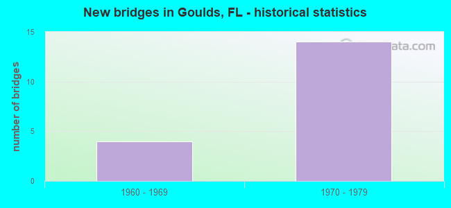
- New bridges - historical statistics
- 41960-1969
- 141970-1979


- Bridge Condition - Deck
- 69.2%Good
- 7.7%Satisfactory
- 7.7%Fair
- 15.4%Poor

- Bridge Condition - Superstructure
- 76.9%Good
- 7.7%Fair
- 15.4%Poor

- Bridge Condition - Substructure
- 7.7%Very good
- 92.3%Good

- Bridge Condition - Channel
- 12.5%Very good
- 50.0%Good
- 12.5%Satisfactory
- 25.0%Fair
Find on map >> Show street view
Structure Number: 870177, Location: 1.6 MILES SOUTH OF US-1 (Lat: 25.559481, Lng: -80.363042), Route carried "on" structure: State highway 821, Year Built: 1973, Status: Open, Structure Length: 5.57m (18.27ft), Average Daily Traffic: 46,850 (year 2020), Truck Traffic: 8%, Average Future Daily Traffic: 81,285 (year 2042), Design Load: HS 20, Features Intersected: OLD CUTLER RD
Minimum Vertical Clearance: 30+ m (98+ ft), Kilometerpoint: 18.173, Lanes on structure: 3, Lanes under structure: 2, Base Highway Network: Yes, Toll: On toll road, Owner: State Toll Authority, Approaching Roadway Width: 17.6m (57.7ft), Skew: 1 degrees, Material/Design: Prestressed concrete, Design/Construction: Stringer/Multi-beam, Number Of Spans In Main Unit: 3, Length of Maximum Span: 30.6m (100.4ft), Curb-To-Curb Width: 17.1m (56.1ft), Out-to-Out Width: 18.1m (59.4ft)
Condition: Deck: Good, Superstructure: Good, Substructure: Good, Operating Rating: 55.2 metric tons, Method Used To Determine Operating Rating: Load and Resistance Factor (LRFR), Inventory Rating: 27.1 metric tons, Method Used To Determine Inventory Rating: Load and Resistance Factor (LRFR), Structural Evaluation: Equal to present minimum criteria, Deck Geometry: Equal to present minimum criteria, Underclear: Superior to present desirable criteria, Approach Roadway Alignment: Equal to present desirable criteria, Designated Inspection Frequency: Every 24 months, Inspection Date: March 2020, Deck Structure Type: Concrete Cast-file-Place
Find on map >> Show street view
Structure Number: 870181, Location: 1.1 MILES SOUTH OF US-1 (Lat: 25.566433, Lng: -80.363131), Route carried "on" structure: State highway 821, Year Built: 1973, Status: Open, Structure Length: 6.34m (20.80ft), Average Daily Traffic: 46,850 (year 2020), Truck Traffic: 8%, Average Future Daily Traffic: 81,285 (year 2042), Design Load: HL 93, Features Intersected: SW 216 ST HAINLIN MILL D
Minimum Vertical Clearance: 30+ m (98+ ft), Kilometerpoint: 18.937, Lanes on structure: 3, Lanes under structure: 6, Base Highway Network: Yes, Toll: On toll road, Owner: State Toll Authority, Approaching Roadway Width: 17.1m (56.1ft), Material/Design: Prestressed concrete, Design/Construction: Stringer/Multi-beam, Number Of Spans In Main Unit: 2, Length of Maximum Span: 31.7m (104.0ft), Curb-To-Curb Width: 17.1m (56.1ft), Out-to-Out Width: 18.2m (59.7ft)
Condition: Deck: Good, Superstructure: Good, Substructure: Good, Operating Rating: 53.9 metric tons, Method Used To Determine Operating Rating: Load and Resistance Factor (LRFR), Inventory Rating: 33.3 metric tons, Method Used To Determine Inventory Rating: Load and Resistance Factor (LRFR), Structural Evaluation: Better than present minimum criteria, Deck Geometry: Equal to present minimum criteria, Underclear: Equal to present minimum criteria, Approach Roadway Alignment: Equal to present desirable criteria, Designated Inspection Frequency: Every 24 months, Inspection Date: March 2020, Deck Structure Type: Concrete Cast-file-Place
Find on map >> Show street view
Structure Number: 870182, Location: 1.0 MILE SOUTH OF US1 (Lat: 25.568450, Lng: -80.363167), Route carried "on" structure: State highway 821, Year Built: 1972, Status: Open, Structure Length: 4.57m (14.99ft), Average Daily Traffic: 65,850 (year 2020), Truck Traffic: 8%, Average Future Daily Traffic: 114,250 (year 2042), Design Load: HL 93, Features Intersected: BLACK CREEK CANAL C-1-N
Minimum Vertical Clearance: 30+ m (98+ ft), Kilometerpoint: 19.171, Lanes on structure: 3, Base Highway Network: Yes, Toll: On toll road, Owner: State Toll Authority, Approaching Roadway Width: 16.3m (53.5ft), Material/Design: Prestressed concrete, Design/Construction: Stringer/Multi-beam, Number Of Spans In Main Unit: 3, Length of Maximum Span: 17.4m (57.1ft), Curb-To-Curb Width: 19.8m (65.0ft), Out-to-Out Width: 20.8m (68.2ft)
Condition: Deck: Good, Superstructure: Good, Substructure: Good, Channel: Good, Operating Rating: 39.8 metric tons, Method Used To Determine Operating Rating: Load and Resistance Factor (LRFR), Inventory Rating: 30.0 metric tons, Method Used To Determine Inventory Rating: Load and Resistance Factor (LRFR), Structural Evaluation: Better than present minimum criteria, Deck Geometry: Superior to present desirable criteria, Waterway Adequacy: Superior to present desirable criteria, Approach Roadway Alignment: Equal to present desirable criteria, Designated Inspection Frequency: Every 24 months, Underwater Inspection Frequency: Every 24 months, Inspection Date: March 2020, Underwater Inspection Date: March 2020, Deck Structure Type: Concrete Cast-file-Place
Find on map >> Show street view
Structure Number: 870183, Location: 0.7 MILES SOUTH OF US 1 (Lat: 25.572844, Lng: -80.363697), Route carried "on" structure: State highway 821, Year Built: 1972, Status: Open, Structure Length: 4.82m (15.81ft), Average Daily Traffic: 65,850 (year 2020), Truck Traffic: 8%, Average Future Daily Traffic: 114,250 (year 2042), Design Load: HL 93, Features Intersected: SW 211 ST GOVT CENTER RD
Minimum Vertical Clearance: 30+ m (98+ ft), Kilometerpoint: 19.671, Lanes on structure: 3, Lanes under structure: 4, Base Highway Network: Yes, Toll: On toll road, Owner: State Toll Authority, Approaching Roadway Width: 8.5m (27.9ft), Material/Design: Prestressed concrete, Design/Construction: Stringer/Multi-beam, Number Of Spans In Main Unit: 2, Length of Maximum Span: 24.1m (79.1ft), Curb-To-Curb Width: 17.1m (56.1ft), Out-to-Out Width: 18.0m (59.1ft)
Condition: Deck: Good, Superstructure: Good, Substructure: Good, Operating Rating: 51.9 metric tons, Method Used To Determine Operating Rating: Load and Resistance Factor (LRFR), Inventory Rating: 39.2 metric tons, Method Used To Determine Inventory Rating: Load and Resistance Factor (LRFR), Structural Evaluation: Better than present minimum criteria, Deck Geometry: Equal to present minimum criteria, Underclear: Equal to present minimum criteria, Approach Roadway Alignment: Equal to present desirable criteria, Designated Inspection Frequency: Every 24 months, Inspection Date: March 2020, Deck Structure Type: Concrete Cast-file-Place
Find on map >> Show street view
Structure Number: 87022, Location: 1.0 MI SOUTH OF US1 (Lat: 25.568444, Lng: -80.363508), Route carried "on" structure: Ramp State highway 821, Year Built: 1972, Status: Open, Structure Length: 3.86m (12.66ft), Average Daily Traffic: 2,700 (year 2020), Truck Traffic: 8%, Average Future Daily Traffic: 4,684 (year 2042), Design Load: HS 20+Mod, Features Intersected: BLACK CREEK CANAL C-1-N
Minimum Vertical Clearance: 30+ m (98+ ft), Kilometerpoint: 0.978, Lanes on structure: 2, Toll: On toll road, Owner: State Toll Authority, Approaching Roadway Width: 9.5m (31.2ft), Material/Design: Prestressed concrete, Design/Construction: Slab, Number Of Spans In Main Unit: 3, Length of Maximum Span: 12.8m (42.0ft), Curb or Sidewalk Widths: Left: 1.4m (4.6ft), Right: 0.0m, Curb-To-Curb Width: 9.1m (29.9ft), Out-to-Out Width: 11.4m (37.4ft)
Condition: Deck: Satisfactory, Superstructure: Good, Substructure: Good, Channel: Good, Operating Rating: 39.6 metric tons, Method Used To Determine Operating Rating: Load and Resistance Factor (LRFR), Inventory Rating: 33.7 metric tons, Method Used To Determine Inventory Rating: Load and Resistance Factor (LRFR), Structural Evaluation: Better than present minimum criteria, Deck Geometry: Meets minimum limits, Waterway Adequacy: Better than present minimum criteria, Approach Roadway Alignment: Equal to present desirable criteria, Designated Inspection Frequency: Every 24 months, Underwater Inspection Frequency: Every 24 months, Inspection Date: March 2020, Underwater Inspection Date: March 2020, Deck Structure Type: Concrete Precast Panels
Find on map >> Show street view
Structure Number: 870221, Location: 1.0 MILE SOUTH OF US1 (Lat: 25.568458, Lng: -80.362508), Route carried "on" structure: Ramp State highway 821, Year Built: 1972, Status: Open, Structure Length: 3.87m (12.70ft), Average Daily Traffic: 2,300 (year 2020), Truck Traffic: 8%, Average Future Daily Traffic: 3,990 (year 2042), Design Load: HS 20+Mod, Features Intersected: BLACK CREEK CANAL C-1-N
Minimum Vertical Clearance: 30+ m (98+ ft), Kilometerpoint: 0.185, Lanes on structure: 2, Toll: On toll road, Owner: State Toll Authority, Approaching Roadway Width: 7.1m (23.3ft), Material/Design: Prestressed concrete, Design/Construction: Slab, Number Of Spans In Main Unit: 3, Length of Maximum Span: 12.8m (42.0ft), Curb-To-Curb Width: 9.1m (29.9ft), Out-to-Out Width: 10.1m (33.1ft)
Condition: Deck: Good, Superstructure: Good, Substructure: Good, Channel: Good, Operating Rating: 59.4 metric tons, Method Used To Determine Operating Rating: Load and Resistance Factor (LRFR), Inventory Rating: 46.7 metric tons, Method Used To Determine Inventory Rating: Load and Resistance Factor (LRFR), Structural Evaluation: Better than present minimum criteria, Deck Geometry: Meets minimum limits, Waterway Adequacy: Better than present minimum criteria, Approach Roadway Alignment: Equal to present desirable criteria, Designated Inspection Frequency: Every 24 months, Underwater Inspection Frequency: Every 24 months, Inspection Date: March 2020, Underwater Inspection Date: March 2020, Deck Structure Type: Concrete Precast Panels
Find on map >> Show street view
Structure Number: 870392, Location: 1.1 MILES SOUTH OF US-1 (Lat: 25.566431, Lng: -80.362806), Route carried "on" structure: State highway 821, Year Built: 1972, Status: Open, Structure Length: 6.34m (20.80ft), Average Daily Traffic: 46,850 (year 2020), Truck Traffic: 8%, Average Future Daily Traffic: 81,285 (year 2042), Design Load: HL 93, Features Intersected: SW 216 ST HAINLIN MILL D
Minimum Vertical Clearance: 30+ m (98+ ft), Kilometerpoint: 18.937, Lanes on structure: 3, Lanes under structure: 6, Base Highway Network: Yes, Toll: On toll road, Owner: State Toll Authority, Approaching Roadway Width: 17.1m (56.1ft), Material/Design: Prestressed concrete, Design/Construction: Stringer/Multi-beam, Number Of Spans In Main Unit: 2, Length of Maximum Span: 31.7m (104.0ft), Curb-To-Curb Width: 17.1m (56.1ft), Out-to-Out Width: 17.8m (58.4ft)
Condition: Deck: Good, Superstructure: Good, Substructure: Good, Operating Rating: 53.9 metric tons, Method Used To Determine Operating Rating: Load and Resistance Factor (LRFR), Inventory Rating: 33.3 metric tons, Method Used To Determine Inventory Rating: Load and Resistance Factor (LRFR), Structural Evaluation: Better than present minimum criteria, Deck Geometry: Equal to present minimum criteria, Underclear: Equal to present minimum criteria, Approach Roadway Alignment: Equal to present desirable criteria, Designated Inspection Frequency: Every 24 months, Inspection Date: March 2020, Deck Structure Type: Concrete Cast-file-Place
Find on map >> Show street view
Structure Number: 870395, Location: 1.0 MILE SOUTH OF US1 (Lat: 25.568450, Lng: -80.362822), Route carried "on" structure: State highway 821, Year Built: 1972, Status: Open, Structure Length: 4.57m (14.99ft), Average Daily Traffic: 65,850 (year 2020), Truck Traffic: 8%, Average Future Daily Traffic: 114,250 (year 2042), Design Load: HL 93, Features Intersected: BLACK CREEK CANAL C-1-N
Minimum Vertical Clearance: 30+ m (98+ ft), Kilometerpoint: 19.169, Lanes on structure: 3, Base Highway Network: Yes, Toll: On toll road, Owner: State Toll Authority, Approaching Roadway Width: 12.4m (40.7ft), Material/Design: Prestressed concrete, Design/Construction: Stringer/Multi-beam, Number Of Spans In Main Unit: 3, Length of Maximum Span: 17.4m (57.1ft), Curb-To-Curb Width: 17.1m (56.1ft), Out-to-Out Width: 18.9m (62.0ft)
Condition: Deck: Good, Superstructure: Good, Substructure: Good, Channel: Good, Operating Rating: 45.1 metric tons, Method Used To Determine Operating Rating: Load and Resistance Factor (LRFR), Inventory Rating: 29.4 metric tons, Method Used To Determine Inventory Rating: Load and Resistance Factor (LRFR), Structural Evaluation: Better than present minimum criteria, Deck Geometry: Equal to present minimum criteria, Waterway Adequacy: Superior to present desirable criteria, Approach Roadway Alignment: Equal to present desirable criteria, Designated Inspection Frequency: Every 24 months, Underwater Inspection Frequency: Every 24 months, Inspection Date: March 2020, Underwater Inspection Date: March 2020, Deck Structure Type: Concrete Cast-file-Place
Find on map >> Show street view
Structure Number: 870396, Location: 0.7 MILES SOUTH OF US-1 (Lat: 25.572947, Lng: -80.363406), Route carried "on" structure: State highway 821, Year Built: 1972, Status: Open, Structure Length: 4.82m (15.81ft), Average Daily Traffic: 65,850 (year 2020), Truck Traffic: 8%, Average Future Daily Traffic: 114,250 (year 2042), Design Load: HL 93, Features Intersected: SW 211 ST GOVT CENTER RD
Minimum Vertical Clearance: 30+ m (98+ ft), Kilometerpoint: 19.674, Lanes on structure: 3, Lanes under structure: 4, Base Highway Network: Yes, Toll: On toll road, Owner: State Toll Authority, Approaching Roadway Width: 17.1m (56.1ft), Material/Design: Prestressed concrete, Design/Construction: Stringer/Multi-beam, Number Of Spans In Main Unit: 2, Length of Maximum Span: 24.1m (79.1ft), Curb-To-Curb Width: 17.1m (56.1ft), Out-to-Out Width: 18.0m (59.1ft)
Condition: Deck: Good, Superstructure: Good, Substructure: Good, Operating Rating: 51.9 metric tons, Method Used To Determine Operating Rating: Load and Resistance Factor (LRFR), Inventory Rating: 39.2 metric tons, Method Used To Determine Inventory Rating: Load and Resistance Factor (LRFR), Structural Evaluation: Better than present minimum criteria, Deck Geometry: Equal to present minimum criteria, Underclear: Equal to present minimum criteria, Approach Roadway Alignment: Equal to present desirable criteria, Designated Inspection Frequency: Every 24 months, Inspection Date: March 2020, Deck Structure Type: Concrete Cast-file-Place
Find on map >> Show street view
Structure Number: 874338, Location: 0.4 Mile S of SW 200th St (Lat: 25.574681, Lng: -80.396944), Route carried "on" structure: County highway , Year Built: 1962, Status: Open, Structure Length: 2.68m (8.79ft), Average Daily Traffic: 3,835 (year 2014), Truck Traffic: 2%, Average Future Daily Traffic: 6,654 (year 2036), Design Load: HS 20, Features Intersected: Black Creek Canal C-1W, Facility Carried by Structure: SW 127th Ave.
Minimum Vertical Clearance: 30+ m (98+ ft), Kilometerpoint: 0.935, Lanes on structure: 2, Owner: County Highway Agency, Approaching Roadway Width: 7.0m (23.0ft), Material/Design: Prestressed concrete, Design/Construction: Slab, Number Of Spans In Main Unit: 3, Length of Maximum Span: 8.9m (29.2ft), Curb or Sidewalk Widths: Left: 1.2m (3.9ft), Right: 1.2m (3.9ft), Curb-To-Curb Width: 8.5m (27.9ft), Out-to-Out Width: 11.6m (38.1ft)
Condition: Deck: Fair, Superstructure: Fair, Substructure: Good, Channel: Fair, Operating Rating: 47.6 metric tons, Method Used To Determine Operating Rating: Load Factor (LF), Inventory Rating: 28.5 metric tons, Method Used To Determine Inventory Rating: Load Factor (LF), Structural Evaluation: Somewhat better than minimum adequacy, Deck Geometry: Meets minimum limits, Waterway Adequacy: Better than present minimum criteria, Approach Roadway Alignment: Equal to present desirable criteria, Designated Inspection Frequency: Every 24 months, Underwater Inspection Frequency: Every 24 months, Inspection Date: May 2020, Underwater Inspection Date: May 2020, Deck Structure Type: Concrete Precast Panels, Wearing Surface/Protective System: Wearing Surface: Bituminous
Find on map >> Show street view
Structure Number: 87434, Location: At SW 137th Ave. (Lat: 25.596583, Lng: -80.413056), Route carried "on" structure: County highway , Year Built: 1962, Year Reconstructed: 2007, Status: Open, Structure Length: 2.67m (8.76ft), Average Daily Traffic: 9,510 (year 2014), Truck Traffic: 1%, Average Future Daily Traffic: 15,268 (year 2036), Design Load: HS 20, Features Intersected: Black Creek Canal C-1W, Facility Carried by Structure: SW 184th Street
Minimum Vertical Clearance: 30+ m (98+ ft), Kilometerpoint: 1.654, Lanes on structure: 5, Owner: County Highway Agency, Approaching Roadway Width: 17.4m (57.1ft), Material/Design: Concrete, Design/Construction: Slab, Number Of Spans In Main Unit: 3, Length of Maximum Span: 9.0m (29.5ft), Curb or Sidewalk Widths: Left: 1.7m (5.6ft), Right: 1.7m (5.6ft), Curb-To-Curb Width: 18.3m (60.0ft), Out-to-Out Width: 23.0m (75.5ft)
Condition: Deck: Good, Superstructure: Good, Substructure: Good, Channel: Satisfactory, Operating Rating: 72.2 metric tons, Method Used To Determine Operating Rating: Load Factor (LF), Inventory Rating: 43.1 metric tons, Method Used To Determine Inventory Rating: Load Factor (LF), Structural Evaluation: Better than present minimum criteria, Deck Geometry: High priority of replacement, Waterway Adequacy: Equal to present minimum criteria, Approach Roadway Alignment: Equal to present desirable criteria, Designated Inspection Frequency: Every 24 months, Underwater Inspection Frequency: Every 24 months, Inspection Date: May 2020, Underwater Inspection Date: May 2020, Deck Structure Type: Concrete Cast-file-Place, Wearing Surface/Protective System: Wearing Surface: Bituminous
Find on map >> Show street view
Structure Number: 874443, Location: 0.5 Mi N of SW 216th St. (Lat: 25.573361, Lng: -80.429444), Route carried "on" structure: County highway , Year Built: 1966, Status: Open, Structure Length: 1.37m (4.49ft), Average Daily Traffic: 6,374 (year 2020), Truck Traffic: 4%, Average Future Daily Traffic: 10,878 (year 2042), Design Load: HL 93, Features Intersected: Canal C-102, Facility Carried by Structure: SW 147th Avenue
Minimum Vertical Clearance: 30+ m (98+ ft), Kilometerpoint: 4.886, Lanes on structure: 2, Owner: County Highway Agency, Approaching Roadway Width: 7.3m (24.0ft), Material/Design: Prestressed concrete, Design/Construction: Slab, Number Of Spans In Main Unit: 1, Length of Maximum Span: 13.7m (44.9ft), Curb or Sidewalk Widths: Left: 1.2m (3.9ft), Right: 1.2m (3.9ft), Curb-To-Curb Width: 8.6m (28.2ft), Out-to-Out Width: 11.6m (38.1ft)
Condition: Deck: Poor, Superstructure: Poor, Substructure: Very good, Channel: Very good, Operating Rating: 52.7 metric tons, Method Used To Determine Operating Rating: Load and Resistance Factor (LRFR), Inventory Rating: 40.6 metric tons, Method Used To Determine Inventory Rating: Load and Resistance Factor (LRFR), Structural Evaluation: Meets minimum limits, Deck Geometry: High priority of replacement, Waterway Adequacy: Better than present minimum criteria, Approach Roadway Alignment: Equal to present desirable criteria, Designated Inspection Frequency: Every 24 months, Other Special Inspection Frequency: Every 12 months, Inspection Date: July 2021, Other Special Inspection Date: July 2021, Deck Structure Type: Concrete Precast Panels, Wearing Surface/Protective System: Wearing Surface: Integral Concrete
Find on map >> Show street view
Structure Number: 874444, Location: 0.4 Mi. E of SW 147th Ave (Lat: 25.565883, Lng: -80.423164), Route carried "on" structure: County highway , Year Built: 1966, Status: Open, Structure Length: 1.68m (5.51ft), Average Daily Traffic: 3,916 (year 2020), Truck Traffic: 3%, Average Future Daily Traffic: 6,377 (year 2042), Design Load: HL 93, Features Intersected: Canal C-102, Facility Carried by Structure: SW 216th Street
Minimum Vertical Clearance: 30+ m (98+ ft), Kilometerpoint: 7.277, Lanes on structure: 2, Owner: County Highway Agency, Approaching Roadway Width: 7.3m (24.0ft), Material/Design: Prestressed concrete, Design/Construction: Slab, Number Of Spans In Main Unit: 2, Length of Maximum Span: 7.9m (25.9ft), Curb or Sidewalk Widths: Left: 1.2m (3.9ft), Right: 1.2m (3.9ft), Curb-To-Curb Width: 8.7m (28.5ft), Out-to-Out Width: 11.6m (38.1ft)
Condition: Deck: Poor, Superstructure: Poor, Substructure: Good, Channel: Fair, Operating Rating: 50.8 metric tons, Method Used To Determine Operating Rating: Load and Resistance Factor (LRFR), Inventory Rating: 39.2 metric tons, Method Used To Determine Inventory Rating: Load and Resistance Factor (LRFR), Structural Evaluation: Meets minimum limits, Deck Geometry: Meets minimum limits, Waterway Adequacy: Better than present minimum criteria, Approach Roadway Alignment: Equal to present desirable criteria, Designated Inspection Frequency: Every 24 months, Underwater Inspection Frequency: Every 24 months, Other Special Inspection Frequency: Every 12 months, Inspection Date: May 2021, Underwater Inspection Date: May 2021, Other Special Inspection Date: May 2021, Deck Structure Type: Concrete Precast Panels, Wearing Surface/Protective System: Wearing Surface: Bituminous
Find on map >> Show street view
Structure Number: 870177, Location: 1.6 MILES SOUTH OF US-1 (Lat: 25.559481, Lng: -80.363042), Route carried "under" structure: City street , Year Built: 1973, Structure Length: 0. m, Average Daily Traffic: 46,850 (year 2020), Truck Traffic: 8%, Features Intersected: OLD CUTLER RD, Facility Carried by Structure: SR821 SB HEFT 11.2
Minimum Vertical Clearance: 5.27m (17.29ft), Kilometerpoint: 18.173, Lanes on structure: 3, Lanes under structure: 2, Material/Design: Prestressed concrete, Design/Construction: Stringer/Multi-beam, Length of Maximum Span: 30.6m (100.4ft)
Find on map >> Show street view
Structure Number: 870181, Location: 1.1 MILES SOUTH OF US-1 (Lat: 25.566433, Lng: -80.363131), Route carried "under" structure: City street , Year Built: 1973, Structure Length: 0. m, Average Daily Traffic: 46,850 (year 2020), Truck Traffic: 8%, Features Intersected: SW 216 ST HAINLIN MILL D, Facility Carried by Structure: SR821 SB HEFT 11.7
Minimum Vertical Clearance: 5.09m (16.70ft), Kilometerpoint: 18.937, Lanes on structure: 3, Lanes under structure: 5, Material/Design: Prestressed concrete, Design/Construction: Stringer/Multi-beam, Length of Maximum Span: 31.7m (104.0ft)
Find on map >> Show street view
Structure Number: 870183, Location: 0.7 MILES SOUTH OF US 1 (Lat: 25.572844, Lng: -80.363697), Route carried "under" structure: City street , Year Built: 1972, Structure Length: 0. m, Average Daily Traffic: 65,850 (year 2020), Truck Traffic: 8%, Features Intersected: SW 211 ST GOVT CENTER RD, Facility Carried by Structure: SR821 SB HEFT 12.2
Minimum Vertical Clearance: 5.12m (16.80ft), Kilometerpoint: 19.671, Lanes on structure: 3, Lanes under structure: 4, Material/Design: Prestressed concrete, Design/Construction: Stringer/Multi-beam, Length of Maximum Span: 24.1m (79.1ft)
Find on map >> Show street view
Structure Number: 870392, Location: 1.1 MILES SOUTH OF US-1 (Lat: 25.566431, Lng: -80.362806), Route carried "under" structure: City street , Year Built: 1972, Structure Length: 0. m, Average Daily Traffic: 46,850 (year 2020), Truck Traffic: 8%, Features Intersected: SW 216 ST HAINLIN MILL D, Facility Carried by Structure: SR821 NB HEFT 11.7
Minimum Vertical Clearance: 5.09m (16.70ft), Kilometerpoint: 18.937, Lanes on structure: 3, Lanes under structure: 5, Material/Design: Prestressed concrete, Design/Construction: Stringer/Multi-beam, Length of Maximum Span: 31.7m (104.0ft)
Find on map >> Show street view
Structure Number: 870396, Location: 0.7 MILES SOUTH OF US-1 (Lat: 25.572947, Lng: -80.363406), Route carried "under" structure: City street , Year Built: 1972, Structure Length: 0. m, Average Daily Traffic: 65,850 (year 2020), Truck Traffic: 8%, Features Intersected: SW 211 ST GOVT CENTER RD, Facility Carried by Structure: SR821 NB HEFT 12.2
Minimum Vertical Clearance: 5.18m (16.99ft), Kilometerpoint: 19.674, Lanes on structure: 3, Lanes under structure: 4, Material/Design: Prestressed concrete, Design/Construction: Stringer/Multi-beam, Length of Maximum Span: 24.1m (79.1ft)