Bridge Statistics for Goldenrod, Florida (FL)
Condition, Traffic, Stress, Structural Evaluation, Project Costs
- National Bridge Inventory (NBI) Statistics
- 10Number of bridges
- 62ft / 19.1mTotal length
- 280,519Total average daily traffic
- 24,927Total average daily truck traffic
- National Bridge Inventory (NBI) Registered Bridges for Goldenrod
- No street view available for this location
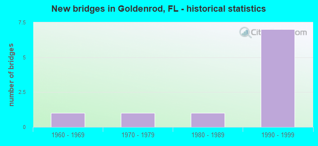
- New bridges - historical statistics
- 11960-1969
- 11970-1979
- 11980-1989
- 71990-1999


- Bridge Condition - Deck
- 66.7%Good
- 16.7%Satisfactory
- 16.7%Fair

- Bridge Condition - Superstructure
- 16.7%Very good
- 66.7%Good
- 16.7%Fair

- Bridge Condition - Channel
- 66.7%Satisfactory
- 33.3%Poor

- Bridge Condition - Culverts
- 50.0%Good
- 50.0%Fair
Find on map >> Show street view
Structure Number: 750305, Location: 0.7 Mi E of SR-436 (Lat: 28.606831, Lng: -81.296439), Route carried "on" structure: State highway 426, Year Built: 1979, Status: Open, Structure Length: 0.67m (2.20ft), Average Daily Traffic: 33,000 (year 2020), Truck Traffic: 6%, Average Future Daily Traffic: 57,255 (year 2042), Design Load: HS 20+Mod, Features Intersected: Crane Strand Canal
Minimum Vertical Clearance: 30+ m (98+ ft), Kilometerpoint: 5.832, Lanes on structure: 5, Owner: State Highway Agency, Approaching Roadway Width: 20.1m (65.9ft), Skew: 20 degrees, Material/Design: Concrete, Design/Construction: Culvert, Number Of Spans In Main Unit: 2, Length of Maximum Span: 3.0m (9.8ft)
Condition: Channel: Poor, Culverts: Fair, Inventory Rating: 67.0 metric tons, Method Used To Determine Inventory Rating: Load Factor (LF), Structural Evaluation: Somewhat better than minimum adequacy, Waterway Adequacy: Equal to present desirable criteria, Approach Roadway Alignment: Equal to present desirable criteria, Designated Inspection Frequency: Every 24 months, Underwater Inspection Frequency: Every 12 months, Other Special Inspection Frequency: Every 12 months, Inspection Date: September 2021, Underwater Inspection Date: September 2021, Other Special Inspection Date: September 2021
Find on map >> Show street view
Structure Number: 754003, Location: 0.3 Mi E of SR-551 (Lat: 28.582917, Lng: -81.281914), Route carried "on" structure: County highway , Year Built: 1962, Status: Posted for load, Structure Length: 2.29m (7.51ft), Average Daily Traffic: 6,669 (year 2021), Truck Traffic: 5%, Average Future Daily Traffic: 7,736 (year 2042), Design Load: H 20, Features Intersected: Crane Strand Canal, Facility Carried by Structure: Bates Road
Minimum Vertical Clearance: 30+ m (98+ ft), Kilometerpoint: 0.000, Lanes on structure: 2, Owner: County Highway Agency, Approaching Roadway Width: 6.1m (20.0ft), Skew: 2 degrees, Material/Design: Prestressed concrete, Design/Construction: Channel Beam, Number Of Spans In Main Unit: 3, Length of Maximum Span: 7.6m (24.9ft), Curb or Sidewalk Widths: Left: 1.5m (4.9ft), Right: 0.3m (1.0ft), Curb-To-Curb Width: 7.3m (24.0ft), Out-to-Out Width: 7.9m (25.9ft)
Condition: Deck: Fair, Superstructure: Fair, Substructure: Good, Channel: Satisfactory, Operating Rating: 20.6 metric tons, Method Used To Determine Operating Rating: Load Factor (LF), Inventory Rating: 12.1 metric tons, Method Used To Determine Inventory Rating: Load Factor (LF), Structural Evaluation: High priority of corrective action, Deck Geometry: High priority of replacement, Waterway Adequacy: Better than present minimum criteria, Approach Roadway Alignment: Equal to present desirable criteria, Bridge Posting: Required (Relationship of Operating Rating to Maximum Legal Load: > 39.9% below), Designated Inspection Frequency: Every 24 months, Other Special Inspection Frequency: Every 12 months, Inspection Date: September 2021, Other Special Inspection Date: September 2021, Deck Structure Type: Concrete Precast Panels, Wearing Surface/Protective System: Wearing Surface: Integral Concrete
Find on map >> Show street view
Structure Number: 754081, Location: 0.8 Mile East of SR-436 (Lat: 28.597536, Lng: -81.291408), Route carried "on" structure: County highway , Year Built: 1987, Status: Open, Structure Length: 2.26m (7.41ft), Average Daily Traffic: 36,500 (year 2021), Truck Traffic: 6%, Average Future Daily Traffic: 63,328 (year 2042), Design Load: HS 20, Features Intersected: Canal E-13, Facility Carried by Structure: University Blvd
Minimum Vertical Clearance: 30+ m (98+ ft), Kilometerpoint: 0.000, Lanes on structure: 6, Owner: County Highway Agency, Approaching Roadway Width: 23.8m (78.1ft), Skew: 25 degrees, Material/Design: Concrete, Design/Construction: Culvert, Number Of Spans In Main Unit: 3, Length of Maximum Span: 7.3m (24.0ft)
Condition: Channel: Satisfactory, Culverts: Good, Inventory Rating: 56.0 metric tons, Method Used To Determine Inventory Rating: Allowable Stress (AS), Structural Evaluation: Better than present minimum criteria, Waterway Adequacy: Superior to present desirable criteria, Approach Roadway Alignment: Equal to present desirable criteria, Designated Inspection Frequency: Every 24 months, Inspection Date: November 2021
Find on map >> Show street view
Structure Number: 770049, Location: 1.6MI N OF UNIVERSITY BLV (Lat: 28.618628, Lng: -81.258875), Route carried "on" structure: State highway 417, Year Built: 1994, Status: Open, Structure Length: 3.54m (11.61ft), Average Daily Traffic: 35,875 (year 2020), Truck Traffic: 12%, Average Future Daily Traffic: 62,243 (year 2042), Design Load: HS 20+Mod, Features Intersected: SR 426 ALOMA AVE
Minimum Vertical Clearance: 30+ m (98+ ft), Kilometerpoint: 0.776, Lanes on structure: 2, Lanes under structure: 6, Base Highway Network: Yes, Toll: On toll road, Owner: State Toll Authority, Approaching Roadway Width: 12.2m (40.0ft), Material/Design: Prestressed concrete, Design/Construction: Stringer/Multi-beam, Number Of Spans In Main Unit: 1, Length of Maximum Span: 35.4m (116.1ft), Curb-To-Curb Width: 12.2m (40.0ft), Out-to-Out Width: 13.1m (43.0ft)
Condition: Deck: Good, Superstructure: Good, Substructure: Good, Operating Rating: 47.0 metric tons, Method Used To Determine Operating Rating: Load and Resistance Factor (LRFR), Inventory Rating: 36.3 metric tons, Method Used To Determine Inventory Rating: Load and Resistance Factor (LRFR), Structural Evaluation: Better than present minimum criteria, Deck Geometry: Better than present minimum criteria, Underclear: Equal to present minimum criteria, Approach Roadway Alignment: Equal to present desirable criteria, Designated Inspection Frequency: Every 24 months, Inspection Date: December 2021, Deck Structure Type: Concrete Cast-file-Place
Find on map >> Show street view
Structure Number: 77005, Location: 1.6MI N OF UNIVERSITY BLV (Lat: 28.618644, Lng: -81.258578), Route carried "on" structure: State highway 417, Year Built: 1994, Status: Open, Structure Length: 3.54m (11.61ft), Average Daily Traffic: 35,875 (year 2020), Truck Traffic: 12%, Average Future Daily Traffic: 62,243 (year 2042), Design Load: HS 20+Mod, Features Intersected: SR 426 ALOMA AVE
Minimum Vertical Clearance: 30+ m (98+ ft), Kilometerpoint: 0.776, Lanes on structure: 2, Lanes under structure: 6, Base Highway Network: Yes, Toll: On toll road, Owner: State Toll Authority, Approaching Roadway Width: 12.2m (40.0ft), Material/Design: Prestressed concrete, Design/Construction: Stringer/Multi-beam, Number Of Spans In Main Unit: 1, Length of Maximum Span: 35.4m (116.1ft), Curb-To-Curb Width: 12.2m (40.0ft), Out-to-Out Width: 13.1m (43.0ft)
Condition: Deck: Satisfactory, Superstructure: Very good, Substructure: Good, Operating Rating: 47.0 metric tons, Method Used To Determine Operating Rating: Load and Resistance Factor (LRFR), Inventory Rating: 36.3 metric tons, Method Used To Determine Inventory Rating: Load and Resistance Factor (LRFR), Structural Evaluation: Better than present minimum criteria, Deck Geometry: Better than present minimum criteria, Underclear: Equal to present minimum criteria, Approach Roadway Alignment: Equal to present desirable criteria, Designated Inspection Frequency: Every 24 months, Inspection Date: December 2021, Deck Structure Type: Concrete Cast-file-Place
Find on map >> Show street view
Structure Number: 770051, Location: 0.4 MI NORTH OF SR 426 (Lat: 28.623164, Lng: -81.257439), Route carried "on" structure: State highway 417, Year Built: 1994, Status: Open, Structure Length: 2.16m (7.09ft), Average Daily Traffic: 29,900 (year 2020), Truck Traffic: 11%, Average Future Daily Traffic: 51,876 (year 2042), Design Load: HS 20+Mod, Features Intersected: PAVED MULTI-USE TRAIL
Minimum Vertical Clearance: 30+ m (98+ ft), Kilometerpoint: 1.297, Lanes on structure: 3, Base Highway Network: Yes, Toll: On toll road, Owner: State Toll Authority, Approaching Roadway Width: 14.6m (47.9ft), Skew: 9 degrees, Material/Design: Prestressed concrete, Design/Construction: Stringer/Multi-beam, Number Of Spans In Main Unit: 1, Length of Maximum Span: 21.6m (70.9ft), Curb-To-Curb Width: 14.6m (47.9ft), Out-to-Out Width: 15.5m (50.9ft)
Condition: Deck: Good, Superstructure: Good, Substructure: Good, Operating Rating: 55.9 metric tons, Method Used To Determine Operating Rating: Load and Resistance Factor (LRFR), Inventory Rating: 46.4 metric tons, Method Used To Determine Inventory Rating: Load and Resistance Factor (LRFR), Structural Evaluation: Better than present minimum criteria, Deck Geometry: Meets minimum limits, Approach Roadway Alignment: Better than present minimum criteria, Designated Inspection Frequency: Every 24 months, Inspection Date: December 2021, Deck Structure Type: Concrete Cast-file-Place
Find on map >> Show street view
Structure Number: 770052, Location: 0.4 MI NORTH OF SR 426 (Lat: 28.623283, Lng: -81.256892), Route carried "on" structure: State highway 417, Year Built: 1994, Status: Open, Structure Length: 2.53m (8.30ft), Average Daily Traffic: 29,900 (year 2020), Truck Traffic: 11%, Average Future Daily Traffic: 51,876 (year 2042), Design Load: HS 20+Mod, Features Intersected: PAVED MULTI-USE TRAIL
Minimum Vertical Clearance: 30+ m (98+ ft), Kilometerpoint: 1.342, Lanes on structure: 2, Base Highway Network: Yes, Toll: On toll road, Owner: State Toll Authority, Approaching Roadway Width: 12.2m (40.0ft), Skew: 6 degrees, Material/Design: Prestressed concrete, Design/Construction: Stringer/Multi-beam, Number Of Spans In Main Unit: 1, Length of Maximum Span: 25.3m (83.0ft), Curb-To-Curb Width: 12.2m (40.0ft), Out-to-Out Width: 13.1m (43.0ft)
Condition: Deck: Good, Superstructure: Good, Substructure: Good, Operating Rating: 46.2 metric tons, Method Used To Determine Operating Rating: Load and Resistance Factor (LRFR), Inventory Rating: 35.7 metric tons, Method Used To Determine Inventory Rating: Load and Resistance Factor (LRFR), Structural Evaluation: Better than present minimum criteria, Deck Geometry: Better than present minimum criteria, Approach Roadway Alignment: Equal to present desirable criteria, Designated Inspection Frequency: Every 24 months, Inspection Date: December 2021, Deck Structure Type: Concrete Cast-file-Place
Find on map >> Show street view
Structure Number: 770053, Location: 0.4 MI NORTH OF SR 426 (Lat: 28.623361, Lng: -81.256597), Route carried "on" structure: Ramp State highway 417, Year Built: 1994, Status: Open, Structure Length: 2.13m (6.99ft), Average Daily Traffic: 2,800 (year 2020), Truck Traffic: 12%, Average Future Daily Traffic: 4,858 (year 2042), Design Load: HS 20+Mod, Features Intersected: PAVED MULTI-USE TRAIL
Minimum Vertical Clearance: 30+ m (98+ ft), Kilometerpoint: 0.536, Lanes on structure: 1, Toll: On toll road, Owner: State Toll Authority, Approaching Roadway Width: 8.2m (26.9ft), Skew: 5 degrees, Material/Design: Prestressed concrete, Design/Construction: Stringer/Multi-beam, Number Of Spans In Main Unit: 1, Length of Maximum Span: 21.3m (69.9ft), Curb-To-Curb Width: 8.2m (26.9ft), Out-to-Out Width: 9.2m (30.2ft)
Condition: Deck: Good, Superstructure: Good, Substructure: Good, Operating Rating: 47.4 metric tons, Method Used To Determine Operating Rating: Load and Resistance Factor (LRFR), Inventory Rating: 36.7 metric tons, Method Used To Determine Inventory Rating: Load and Resistance Factor (LRFR), Structural Evaluation: Better than present minimum criteria, Deck Geometry: Superior to present desirable criteria, Approach Roadway Alignment: Equal to present desirable criteria, Designated Inspection Frequency: Every 24 months, Inspection Date: December 2021, Deck Structure Type: Concrete Cast-file-Place
Find on map >> Show street view
Structure Number: 770049, Location: 1.6MI N OF UNIVERSITY BLV (Lat: 28.618628, Lng: -81.258875), Route carried "under" structure: State highway 426, Year Built: 1994, Structure Length: 0. m, Average Daily Traffic: 35,000 (year 2020), Truck Traffic: 7%, Features Intersected: SR 426 ALOMA AVE, Facility Carried by Structure: SR 417 SB 38.2
Minimum Vertical Clearance: 5.18m (16.99ft), Kilometerpoint: 2.565, Lanes on structure: 2, Lanes under structure: 6, Material/Design: Prestressed concrete, Design/Construction: Stringer/Multi-beam, Length of Maximum Span: 35.4m (116.1ft)
Find on map >> Show street view
Structure Number: 77005, Location: 1.6MI N OF UNIVERSITY BLV (Lat: 28.618644, Lng: -81.258578), Route carried "under" structure: State highway 426, Year Built: 1994, Structure Length: 0. m, Average Daily Traffic: 35,000 (year 2020), Truck Traffic: 7%, Features Intersected: SR 426 ALOMA AVE, Facility Carried by Structure: SR 417 NB 38.2
Minimum Vertical Clearance: 5.17m (16.96ft), Kilometerpoint: 2.593, Lanes on structure: 2, Lanes under structure: 6, Material/Design: Prestressed concrete, Design/Construction: Stringer/Multi-beam, Length of Maximum Span: 35.4m (116.1ft)