Bridge Statistics for Glenville, New York (NY)
Condition, Traffic, Stress, Structural Evaluation, Project Costs
- National Bridge Inventory (NBI) Statistics
- 21Number of bridges
- 151ft / 46.3mTotal length
- $37,796,000Total costs
- 146,271Total average daily traffic
- 5,218Total average daily truck traffic
- National Bridge Inventory (NBI) Registered Bridges for Glenville
- No street view available for this location
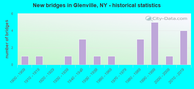
- New bridges - historical statistics
- 11900-1909
- 11910-1919
- 11930-1939
- 31940-1949
- 11950-1959
- 11960-1969
- 31980-1989
- 51990-1999
- 12000-2009
- 42010-2019

- Reconstructed bridges - Historical Statistics
- 11990-1999
- 02000-2009
- 12010-2019
- 12020-2022


- Bridge Condition - Deck
- 33.3%Excellent
- 16.7%Very good
- 33.3%Good
- 16.7%Satisfactory

- Bridge Condition - Superstructure
- 25.0%Excellent
- 25.0%Very good
- 25.0%Good
- 25.0%Satisfactory

- Bridge Condition - Substructure
- 25.0%Excellent
- 37.5%Very good
- 12.5%Good
- 25.0%Fair

- Bridge Condition - Channel
- 12.5%Excellent
- 12.5%Very good
- 50.0%Good
- 25.0%Satisfactory

- Bridge Condition - Culverts
- 50.0%Very good
- 50.0%Good
Find on map >> Show street view
Structure Number: 1002579, Location: 0.2 MI N JCT RTS 5 & 103 (Lat: 42.882150, Lng: -74.042225), Route carried "on" structure: State highway 5, Year Built: 1952, Year Reconstructed: 1996, Status: Open, Structure Length: 5.24m (17.19ft), Average Daily Traffic: 10,987 (year 2014), Truck Traffic: 6%, Average Future Daily Traffic: 13,347 (year 2040), Design Load: HS 25 or greater, Features Intersected: AMTRAK
Minimum Vertical Clearance: 30+ m (98+ ft), Kilometerpoint: 3.829, Lanes on structure: 4, Base Highway Network: Yes, Owner: State Highway Agency, Approaching Roadway Width: 19.8m (65.0ft), Skew: 36 degrees, Material/Design: Steel continuous, Design/Construction: Stringer/Multi-beam, Number Of Spans In Main Unit: 2, Length of Maximum Span: 25.6m (84.0ft), Curb-To-Curb Width: 19.8m (65.0ft), Out-to-Out Width: 20.8m (68.2ft)
Condition: Deck: Satisfactory, Superstructure: Satisfactory, Substructure: Fair, Operating Rating: 82.6 metric tons, Method Used To Determine Operating Rating: Load Factor (LF), Inventory Rating: 44.5 metric tons, Method Used To Determine Inventory Rating: Load Factor (LF), Structural Evaluation: Somewhat better than minimum adequacy, Deck Geometry: Better than present minimum criteria, Underclear: Meets minimum limits, Approach Roadway Alignment: Equal to present desirable criteria, Length Of Structure Improvement: 5.24m (17.19ft), Designated Inspection Frequency: Every 24 months, Inspection Date: October 2020, Bridge Improvement Cost: $5,240,000, Roadway Improvement Cost: $3,068,000, Total Project Cost: $8,308,000 ( Estimate for 2021), Deck Structure Type: Concrete Cast-file-Place, Wearing Surface/Protective System: Wearing Surface: Integral Concrete, Deck Protection: Epoxy Coated Reinforcing
Find on map >> Show street view
Structure Number: 102631, Location: 4.6 MI SW JCT 50 & 146A (Lat: 42.875200, Lng: -73.930017), Route carried "on" structure: State highway 50, Year Built: 2008, Status: Open, Structure Length: 0.88m (2.89ft), Average Daily Traffic: 15,539 (year 2010), Truck Traffic: 5%, Average Future Daily Traffic: 15,612 (year 2040), Design Load: HS 25 or greater, Features Intersected: INDIAN KILL
Minimum Vertical Clearance: 30+ m (98+ ft), Kilometerpoint: 6.307, Lanes on structure: 2, Base Highway Network: Yes, Owner: State Highway Agency, Approaching Roadway Width: 10.7m (35.1ft), Material/Design: Concrete, Design/Construction: Culvert, Number Of Spans In Main Unit: 1, Length of Maximum Span: 8.5m (27.9ft), Curb or Sidewalk Widths: Left: 1.7m (5.6ft), Right: 0.0m, Curb-To-Curb Width: 10.8m (35.4ft), Out-to-Out Width: 13.7m (44.9ft)
Condition: Channel: Good, Culverts: Very good, Operating Rating: 66.1 metric tons, Method Used To Determine Operating Rating: Load and Resistance Factor Rating (LRFR) rating reported by rating factor(RF) method using HL-93 loadings, Inventory Rating: 51.2 metric tons, Method Used To Determine Inventory Rating: Load and Resistance Factor Rating (LRFR) rating reported by rating factor(RF) method using HL-93 loadings, Structural Evaluation: Equal to present desirable criteria, Deck Geometry: Meets minimum limits, Waterway Adequacy: Superior to present desirable criteria, Approach Roadway Alignment: Equal to present desirable criteria, Length Of Structure Improvement: 0.88m (2.89ft), Designated Inspection Frequency: Every 24 months, Inspection Date: March 2020, Bridge Improvement Cost: $286,000, Roadway Improvement Cost: $167,000, Total Project Cost: $453,000 ( Estimate for 2021), Wearing Surface/Protective System: Wearing Surface: Bituminous
Find on map >> Show street view
Structure Number: 102632, Location: 2.4 MI SW JCT 50 & 146A (Lat: 42.898822, Lng: -73.908789), Route carried "on" structure: State highway 50, Year Built: 1994, Status: Open, Structure Length: 3.78m (12.40ft), Average Daily Traffic: 15,539 (year 2010), Truck Traffic: 5%, Average Future Daily Traffic: 15,612 (year 2040), Design Load: HS 25 or greater, Features Intersected: ALPLAUS KILL
Minimum Vertical Clearance: 30+ m (98+ ft), Kilometerpoint: 9.622, Lanes on structure: 2, Base Highway Network: Yes, Owner: State Highway Agency, Approaching Roadway Width: 17.1m (56.1ft), Skew: 22 degrees, Material/Design: Steel, Design/Construction: Stringer/Multi-beam, Number Of Spans In Main Unit: 1, Length of Maximum Span: 36.5m (119.8ft), Curb-To-Curb Width: 17.1m (56.1ft), Out-to-Out Width: 17.7m (58.1ft)
Condition: Deck: Good, Superstructure: Good, Substructure: Good, Channel: Good, Operating Rating: 89.8 metric tons, Method Used To Determine Operating Rating: Load Factor (LF), Inventory Rating: 48.1 metric tons, Method Used To Determine Inventory Rating: Load Factor (LF), Structural Evaluation: Better than present minimum criteria, Deck Geometry: Superior to present desirable criteria, Waterway Adequacy: Superior to present desirable criteria, Approach Roadway Alignment: Equal to present desirable criteria, Length Of Structure Improvement: 3.77m (12.37ft), Designated Inspection Frequency: Every 24 months, Inspection Date: March 2020, Bridge Improvement Cost: $1,684,000, Roadway Improvement Cost: $986,000, Total Project Cost: $2,670,000 ( Estimate for 2021), Deck Structure Type: Concrete Cast-file-Place, Wearing Surface/Protective System: Wearing Surface: Integral Concrete, Deck Protection: Epoxy Coated Reinforcing
Find on map >> Show street view
Structure Number: 10384, Location: 1.5 MI N JCT RTS 5+ 147 (Lat: 42.847228, Lng: -73.978144), Route carried "on" structure: State highway 147, Year Built: 1983, Status: Open, Structure Length: 6.98m (22.90ft), Average Daily Traffic: 5,547 (year 2020), Truck Traffic: 7%, Average Future Daily Traffic: 6,738 (year 2040), Design Load: H 20, Features Intersected: VLEY ROAD CR 19G, CSX TR
Minimum Vertical Clearance: 30+ m (98+ ft), Kilometerpoint: 2.365, Lanes on structure: 2, Lanes under structure: 2, Base Highway Network: Yes, Owner: State Highway Agency, Approaching Roadway Width: 13.4m (44.0ft), Skew: 24 degrees, Material/Design: Steel continuous, Design/Construction: Stringer/Multi-beam, Number Of Spans In Main Unit: 2, Length of Maximum Span: 33.8m (110.9ft), Curb or Sidewalk Widths: Left: 0.0m, Right: 1.5m (4.9ft), Curb-To-Curb Width: 14.1m (46.3ft), Out-to-Out Width: 16.5m (54.1ft)
Condition: Deck: Good, Superstructure: Very good, Substructure: Fair, Operating Rating: 75.5 metric tons, Method Used To Determine Operating Rating: Load and Resistance Factor Rating (LRFR) rating reported by rating factor(RF) method using HL-93 loadings, Inventory Rating: 58.3 metric tons, Method Used To Determine Inventory Rating: Load and Resistance Factor Rating (LRFR) rating reported by rating factor(RF) method using HL-93 loadings, Structural Evaluation: Somewhat better than minimum adequacy, Deck Geometry: Superior to present desirable criteria, Underclear: Meets minimum limits, Approach Roadway Alignment: Equal to present desirable criteria, Length Of Structure Improvement: 6.97m (22.87ft), Designated Inspection Frequency: Every 24 months, Inspection Date: September 2020, Bridge Improvement Cost: $2,352,000, Roadway Improvement Cost: $1,378,000, Total Project Cost: $3,730,000 ( Estimate for 2021), Deck Structure Type: Concrete Cast-file-Place, Wearing Surface/Protective System: Wearing Surface: Integral Concrete, Deck Protection: Epoxy Coated Reinforcing
Find on map >> Show street view
Structure Number: 130495, Location: 4.1MI NE OF SCHENECTADY (Lat: 42.867131, Lng: -73.902575), Route carried "on" structure: State highway 914V, Year Built: 2013, Status: Open, Structure Length: 2.35m (7.71ft), Average Daily Traffic: 8,146 (year 2018), Truck Traffic: 2%, Average Future Daily Traffic: 8,184 (year 2040), Design Load: HL 93, Features Intersected: ALPLAUS KILL
Minimum Vertical Clearance: 30+ m (98+ ft), Kilometerpoint: 2.478, Lanes on structure: 2, Base Highway Network: Yes, Owner: State Highway Agency, Approaching Roadway Width: 10.4m (34.1ft), Skew: 2 degrees, Material/Design: Prestressed concrete, Design/Construction: Box Beam or Girders - Multiple, Number Of Spans In Main Unit: 1, Length of Maximum Span: 21.9m (71.9ft), Curb-To-Curb Width: 10.2m (33.5ft), Out-to-Out Width: 11.3m (37.1ft)
Condition: Deck: Very good, Superstructure: Excellent, Substructure: Very good, Channel: Satisfactory, Operating Rating: 98.0 metric tons, Method Used To Determine Operating Rating: Load Factor (LF), Inventory Rating: 50.8 metric tons, Method Used To Determine Inventory Rating: Load Factor (LF), Structural Evaluation: Equal to present desirable criteria, Deck Geometry: Meets minimum limits, Waterway Adequacy: Equal to present minimum criteria, Approach Roadway Alignment: Better than present minimum criteria, Length Of Structure Improvement: 2.34m (7.68ft), Designated Inspection Frequency: Every 24 months, Inspection Date: October 2021, Bridge Improvement Cost: $1,207,000, Roadway Improvement Cost: $707,000, Total Project Cost: $1,915,000 ( Estimate for 2021), Deck Structure Type: Concrete Cast-file-Place, Wearing Surface/Protective System: Wearing Surface: Monolithic Concrete, Deck Protection: Epoxy Coated Reinforcing
Find on map >> Show street view
Structure Number: 325948, Location: .8 MI W OF REXFORD (Lat: 42.854669, Lng: -73.903064), Route carried "on" structure: County highway , Year Built: 1969, Year Reconstructed: 2016, Status: Open, Structure Length: 3.96m (12.99ft), Average Daily Traffic: 2,780 (year 2020), Truck Traffic: 4%, Average Future Daily Traffic: 3,892 (year 2040), Design Load: HS 20+Mod, Features Intersected: ALPLAUS KILL, Facility Carried by Structure: ALPLAUS AVENUE
Minimum Vertical Clearance: 30+ m (98+ ft), Kilometerpoint: 0.499, Lanes on structure: 2, Owner: County Highway Agency, Approaching Roadway Width: 7.3m (24.0ft), Skew: 1 degrees, Material/Design: Steel continuous, Design/Construction: Stringer/Multi-beam, Number Of Spans In Main Unit: 2, Length of Maximum Span: 18.8m (61.7ft), Curb or Sidewalk Widths: Left: 1.8m (5.9ft), Right: 1.8m (5.9ft), Curb-To-Curb Width: 6.7m (22.0ft), Out-to-Out Width: 10.5m (34.4ft)
Condition: Deck: Excellent, Superstructure: Excellent, Substructure: Excellent, Channel: Excellent, Operating Rating: 86.2 metric tons, Method Used To Determine Operating Rating: Load Factor (LF), Inventory Rating: 51.7 metric tons, Method Used To Determine Inventory Rating: Load Factor (LF), Structural Evaluation: Superior to present desirable criteria, Deck Geometry: High priority of replacement, Waterway Adequacy: Equal to present minimum criteria, Approach Roadway Alignment: Equal to present desirable criteria, Length Of Structure Improvement: 3.96m (12.99ft), Designated Inspection Frequency: Every 24 months, Underwater Inspection Frequency: Every 60 months, Inspection Date: June 2021, Underwater Inspection Date: June 2020, Bridge Improvement Cost: $948,000, Roadway Improvement Cost: $555,000, Total Project Cost: $1,503,000 ( Estimate for 2021), Deck Structure Type: Concrete Cast-file-Place, Wearing Surface/Protective System: Wearing Surface: Integral Concrete
Find on map >> Show street view
Structure Number: 330492, Location: 1.4MISW OF EAST GLENVILLE (Lat: 42.881594, Lng: -73.946967), Route carried "on" structure: County highway , Year Built: 1993, Status: Open, Structure Length: 0.67m (2.20ft), Average Daily Traffic: 2,634 (year 2020), Truck Traffic: 3%, Average Future Daily Traffic: 3,259 (year 2040), Design Load: HS 25 or greater, Features Intersected: INDIAN KILL, Facility Carried by Structure: DROMS ROAD
Minimum Vertical Clearance: 30+ m (98+ ft), Kilometerpoint: 0.434, Lanes on structure: 2, Owner: County Highway Agency, Approaching Roadway Width: 9.1m (29.9ft), Material/Design: Concrete, Design/Construction: Frame, Number Of Spans In Main Unit: 1, Length of Maximum Span: 6.0m (19.7ft), Curb-To-Curb Width: 9.2m (30.2ft), Out-to-Out Width: 9.8m (32.2ft)
Condition: Superstructure: Good, Substructure: Very good, Channel: Satisfactory, Operating Rating: 76.9 metric tons, Method Used To Determine Operating Rating: Field evaluation and documented engineering judgment, Inventory Rating: 40.8 metric tons, Method Used To Determine Inventory Rating: Field evaluation and documented engineering judgment, Structural Evaluation: Better than present minimum criteria, Deck Geometry: Meets minimum limits, Waterway Adequacy: Somewhat better than minimum adequacy, Approach Roadway Alignment: Equal to present desirable criteria, Length Of Structure Improvement: 0.67m (2.20ft), Designated Inspection Frequency: Every 24 months, Inspection Date: April 2021, Bridge Improvement Cost: $199,000, Roadway Improvement Cost: $117,000, Total Project Cost: $316,000 ( Estimate for 2021)
Find on map >> Show street view
Structure Number: 330493, Location: 1.3MI SW OF BURNT HILLS (Lat: 42.905083, Lng: -73.918517), Route carried "on" structure: County highway , Year Built: 2015, Status: Open, Structure Length: 1.86m (6.10ft), Average Daily Traffic: 1,839 (year 2020), Truck Traffic: 3%, Average Future Daily Traffic: 2,275 (year 2040), Design Load: HL 93, Features Intersected: ALPLAUS KILL, Facility Carried by Structure: VAN VORST ROAD
Minimum Vertical Clearance: 30+ m (98+ ft), Kilometerpoint: 1.319, Lanes on structure: 2, Owner: County Highway Agency, Approaching Roadway Width: 9.8m (32.2ft), Material/Design: Concrete, Design/Construction: Arch - Deck, Number Of Spans In Main Unit: 1, Length of Maximum Span: 18.3m (60.0ft), Curb-To-Curb Width: 9.7m (31.8ft), Out-to-Out Width: 10.7m (35.1ft)
Condition: Superstructure: Very good, Substructure: Excellent, Channel: Very good, Operating Rating: 85.6 metric tons, Method Used To Determine Operating Rating: Field evaluation and documented engineering judgment, Inventory Rating: 40.8 metric tons, Method Used To Determine Inventory Rating: Field evaluation and documented engineering judgment, Structural Evaluation: Equal to present desirable criteria, Deck Geometry: Somewhat better than minimum adequacy, Waterway Adequacy: Equal to present desirable criteria, Approach Roadway Alignment: Meets minimum limits, Length Of Structure Improvement: 1.85m (6.07ft), Designated Inspection Frequency: Every 24 months, Inspection Date: August 2021, Bridge Improvement Cost: $835,000, Roadway Improvement Cost: $489,000, Total Project Cost: $1,324,000 ( Estimate for 2021)
Find on map >> Show street view
Structure Number: 330494, Location: 1.2 MI N OF E GLENVILLE (Lat: 42.908939, Lng: -73.919467), Route carried "on" structure: County highway , Year Built: 1997, Status: Open, Structure Length: 0.85m (2.79ft), Average Daily Traffic: 2,378 (year 2017), Truck Traffic: 5%, Average Future Daily Traffic: 2,942 (year 2040), Design Load: HS 25 or greater, Features Intersected: LA RUE BROOK, Facility Carried by Structure: LAKE HILL ROAD
Minimum Vertical Clearance: 30+ m (98+ ft), Kilometerpoint: 0.161, Lanes on structure: 2, Owner: County Highway Agency, Approaching Roadway Width: 9.1m (29.9ft), Skew: 1 degrees, Material/Design: Concrete, Design/Construction: Culvert, Number Of Spans In Main Unit: 1, Length of Maximum Span: 8.2m (26.9ft)
Condition: Channel: Good, Culverts: Good, Operating Rating: 78.4 metric tons, Method Used To Determine Operating Rating: Field evaluation and documented engineering judgment, Inventory Rating: 40.8 metric tons, Method Used To Determine Inventory Rating: Field evaluation and documented engineering judgment, Structural Evaluation: Better than present minimum criteria, Waterway Adequacy: Equal to present minimum criteria, Approach Roadway Alignment: Equal to present desirable criteria, Length Of Structure Improvement: 0.85m (2.79ft), Designated Inspection Frequency: Every 24 months, Inspection Date: June 2021, Bridge Improvement Cost: $340,000, Roadway Improvement Cost: $199,000, Total Project Cost: $539,000 ( Estimate for 2021)
Find on map >> Show street view
Structure Number: 405033, Location: JCT RT 911F & MOHAWK RIVR (Lat: 42.830261, Lng: -73.930864), Route carried "on" structure: State highway 911F, Year Built: 1985, Year Reconstructed: 2020, Status: Open, Structure Length: 19.69m (64.60ft), Average Daily Traffic: 20,561 (year 2020), Truck Traffic: 6%, Average Future Daily Traffic: 20,657 (year 2040), Design Load: HS 20, Features Intersected: MOHAWK R/ERIE CAN, BIKE
Minimum Vertical Clearance: 30+ m (98+ ft), Kilometerpoint: 0.981, Lanes on structure: 4, Base Highway Network: Yes, Owner: State Highway Agency, Approaching Roadway Width: 20.4m (66.9ft), Skew: 23 degrees, Navigation Control: Yes ( Vertical Clearance: 6.0m (19.7ft), Horizontal Clearance: 60.9m (199.8ft)), Material/Design: Steel continuous, Design/Construction: Stringer/Multi-beam, Number Of Spans In Main Unit: 3, Length of Maximum Span: 82.2m (269.7ft), Curb or Sidewalk Widths: Left: 3.2m (10.5ft), Right: 0.0m, Curb-To-Curb Width: 20.3m (66.6ft), Out-to-Out Width: 24.2m (79.4ft)
Condition: Deck: Excellent, Superstructure: Satisfactory, Substructure: Very good, Channel: Good, Inventory Rating: 32.7 metric tons, Method Used To Determine Inventory Rating: Field evaluation and documented engineering judgment, Structural Evaluation: Equal to present minimum criteria, Deck Geometry: Equal to present desirable criteria, Waterway Adequacy: Somewhat better than minimum adequacy, Approach Roadway Alignment: Equal to present desirable criteria, Length Of Structure Improvement: 19.69m (64.60ft), Designated Inspection Frequency: Every 24 months, Underwater Inspection Frequency: Every 60 months, Inspection Date: November 2020, Underwater Inspection Date: October 2021, Bridge Improvement Cost: $10,745,000, Roadway Improvement Cost: $6,293,000, Total Project Cost: $17,038,000 ( Estimate for 2021), Deck Structure Type: Concrete Cast-file-Place, Wearing Surface/Protective System: Wearing Surface: Integral Concrete, Deck Protection: Epoxy Coated Reinforcing
Find on map >> Show street view
Structure Number: 10384, Location: 1.5 MI N JCT RTS 5+ 147 (Lat: 42.847228, Lng: -73.978144), Route carried "under" structure: County highway , Year Built: 1983, Structure Length: 0. m, Average Daily Traffic: 5,658 (year 2020), Truck Traffic: 7%, Features Intersected: VLEY ROAD CR 19G, CSX TR, Facility Carried by Structure: RTE 147
Minimum Vertical Clearance: 6.30m (20.67ft), Kilometerpoint: 0.000, Lanes on structure: 2, Lanes under structure: 2, Material/Design: Steel continuous, Design/Construction: Stringer/Multi-beam, Length of Maximum Span: 33.8m (110.9ft)
Find on map >> Show street view
Structure Number: 700258, Location: 2.5 MI W JCT SH 5 & SH147 (Lat: 42.850361, Lng: -74.001947), Route carried "under" structure: State highway 5, Year Built: 1936, Structure Length: 0. m, Average Daily Traffic: 14,106 (year 2000), Features Intersected: RTE 5, Facility Carried by Structure: DELAWARE & HUDSON
Minimum Vertical Clearance: 4.39m (14.40ft), Kilometerpoint: 8.833, Lanes under structure: 2, Material/Design: Steel, Design/Construction: Girder and Floorbeam System, Length of Maximum Span: 33.8m (110.9ft)
Find on map >> Show street view
Structure Number: 730509, Location: 2.8 MI NE OF SCHENECTADY (Lat: 42.863364, Lng: -73.906031), Route carried "under" structure: County highway , Year Built: 1918, Structure Length: 0. m, Average Daily Traffic: 6,860 (year 2018), Truck Traffic: 6%, Features Intersected: CO RD 29 MAPLE AV, Facility Carried by Structure: SPRINGFIELD TERMN
Minimum Vertical Clearance: 3.50m (11.48ft), Kilometerpoint: 3.202, Lanes under structure: 2, Material/Design: Steel, Design/Construction: Girder and Floorbeam System, Length of Maximum Span: 10.9m (35.8ft)
Find on map >> Show street view
Structure Number: 730511, Location: INT 914V & BRUCE DR (Lat: 42.866803, Lng: -73.898483), Route carried "under" structure: State highway , Year Built: 2013, Structure Length: 0. m, Average Daily Traffic: 9,163 (year 2012), Features Intersected: 914V 914V16011017, Facility Carried by Structure: SPRINGFIELD TERMN
Minimum Vertical Clearance: 4.78m (15.68ft), Kilometerpoint: 2.735, Lanes under structure: 2, Material/Design: Steel, Design/Construction: Stringer/Multi-beam, Length of Maximum Span: 21.0m (68.9ft)
Find on map >> Show street view
Structure Number: 7305121, Location: 3.5MINW OF SCOTIA (Lat: 42.869419, Lng: -74.023939), Route carried "under" structure: Other road , Year Built: 1945, Structure Length: 0. m, Average Daily Traffic: 223 (year 2005), Truck Traffic: 6%, Features Intersected: WASHOUT RD C R 51, WASHO, Facility Carried by Structure: CSX TRANSPRTATION
Minimum Vertical Clearance: 4.36m (14.30ft), Kilometerpoint: 0.000, Lanes under structure: 2, Material/Design: Steel, Design/Construction: Stringer/Multi-beam, Length of Maximum Span: 15.8m (51.8ft)
Find on map >> Show street view
Structure Number: 7305122, Location: 3.5 MI NW OF SCOTIA (Lat: 42.869436, Lng: -74.023917), Route carried "under" structure: Other road , Year Built: 1945, Structure Length: 0. m, Average Daily Traffic: 519 (year 2005), Truck Traffic: 8%, Features Intersected: WASHOUT RD C R 51, WASHO, Facility Carried by Structure: CSX TRANSPRTATION
Minimum Vertical Clearance: 4.36m (14.30ft), Kilometerpoint: 0.000, Lanes under structure: 2, Material/Design: Steel, Design/Construction: Stringer/Multi-beam, Length of Maximum Span: 15.8m (51.8ft)
Find on map >> Show street view
Structure Number: 7305123, Location: 3.5 MI NW OF SCOTIA (Lat: 42.869450, Lng: -74.023894), Route carried "under" structure: Other road , Year Built: 1900, Structure Length: 0. m, Average Daily Traffic: 415 (year 1978), Features Intersected: WASHOUT RD C R 51, WASHO, Facility Carried by Structure: CSX TRANSPRTATION
Minimum Vertical Clearance: 4.36m (14.30ft), Kilometerpoint: 0.000, Lanes under structure: 2, Material/Design: Steel, Design/Construction: Stringer/Multi-beam, Length of Maximum Span: 15.8m (51.8ft)
Find on map >> Show street view
Structure Number: 7305124, Location: 3.5 MI NW OF SCOTIA (Lat: 42.869486, Lng: -74.023847), Route carried "under" structure: Other road , Year Built: 1945, Structure Length: 0. m, Average Daily Traffic: 415 (year 1978), Features Intersected: WASHOUT RD C R 51, WASHO, Facility Carried by Structure: CSX TRANSPRTATION
Minimum Vertical Clearance: 4.36m (14.30ft), Kilometerpoint: 0.000, Lanes under structure: 2, Material/Design: Steel, Design/Construction: Stringer/Multi-beam, Length of Maximum Span: 15.8m (51.8ft)
Find on map >> Show street view
Structure Number: 771524, Location: .1 MI S JCT SH 5 & I890 (Lat: 42.851611, Lng: -74.005108), Route carried "under" structure: State highway 890, Year Built: 1998, Structure Length: 0. m, Average Daily Traffic: 13,500 (year 2021), Features Intersected: 890 890 16011108 WB, RTE, Facility Carried by Structure: SPRINGFLD TRMNL
Minimum Vertical Clearance: 5.18m (16.99ft), Kilometerpoint: 16.090, Lanes under structure: 2, Material/Design: Steel, Design/Construction: Girder and Floorbeam System, Length of Maximum Span: 32.3m (106.0ft)
Find on map >> Show street view
Structure Number: 771524, Location: .1 MI S JCT SH 5 & I890 (Lat: 42.851611, Lng: -74.005108), Route carried "under" structure: State highway , Year Built: 1998, Structure Length: 0. m, Features Intersected: 890 890 16011108 WB, RTE, Facility Carried by Structure: SPRINGFLD TRMNL
Minimum Vertical Clearance: 5.54m (18.18ft), Kilometerpoint: 16.090, Lanes under structure: 2, Material/Design: Steel, Design/Construction: Girder and Floorbeam System, Length of Maximum Span: 32.3m (106.0ft)
Find on map >> Show street view
Structure Number: 771557, Location: Hetcheltown Rd and 914V (Lat: 42.867131, Lng: -73.903036), Route carried "under" structure: State highway , Year Built: 2013, Structure Length: 0. m, Average Daily Traffic: 9,462 (year 2013), Features Intersected: 914V 914V16011015, Facility Carried by Structure: D&H Railroad
Minimum Vertical Clearance: 3.63m (11.91ft), Kilometerpoint: 2.414, Lanes under structure: 2, Material/Design: Steel, Design/Construction: Stringer/Multi-beam, Length of Maximum Span: 18.9m (62.0ft)