Bridge Statistics for Fruitville, Florida (FL)
Condition, Traffic, Stress, Structural Evaluation, Project Costs
- National Bridge Inventory (NBI) Statistics
- 34Number of bridges
- 636ft / 194mTotal length
- 884,536Total average daily traffic
- 69,013Total average daily truck traffic
- National Bridge Inventory (NBI) Registered Bridges for Fruitville
- No street view available for this location
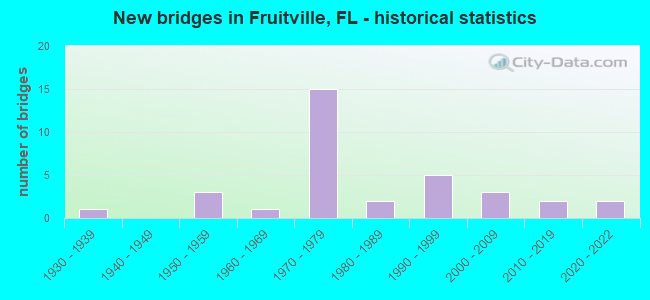
- New bridges - historical statistics
- 11930-1939
- 31950-1959
- 11960-1969
- 151970-1979
- 21980-1989
- 51990-1999
- 32000-2009
- 22010-2019
- 22020-2022

- Reconstructed bridges - Historical Statistics
- 11980-1989
- 11990-1999
- 42000-2009
- 22010-2019


- Bridge Condition - Deck
- 4.3%Very good
- 91.3%Good
- 4.3%Satisfactory

- Bridge Condition - Superstructure
- 13.0%Very good
- 78.3%Good
- 4.3%Satisfactory
- 4.3%Fair

- Bridge Condition - Substructure
- 17.4%Very good
- 69.6%Good
- 13.0%Satisfactory

- Bridge Condition - Channel
- 29.2%Excellent
- 4.2%Very good
- 45.8%Good
- 16.7%Satisfactory
- 4.2%Fair

- Bridge Condition - Culverts
- 57.1%Good
- 42.9%Satisfactory
Find on map >> Show street view
Structure Number: 20008, Location: 1.25MI N of LECANTO HWY (Lat: 28.988694, Lng: -82.349556), Route carried "on" structure: State highway 200, Year Built: 1935, Status: Open, Structure Length: 9.07m (29.76ft), Average Daily Traffic: 13,500 (year 2021), Truck Traffic: 8%, Average Future Daily Traffic: 23,422 (year 2041), Design Load: H 15, Features Intersected: WITHLACOOCHEE RIVER
Minimum Vertical Clearance: 30+ m (98+ ft), Kilometerpoint: 10.662, Lanes on structure: 2, Base Highway Network: Yes, Owner: State Highway Agency, Approaching Roadway Width: 7.4m (24.3ft), Material/Design: Concrete, Design/Construction: Tee Beam, Number Of Spans In Main Unit: 9, Length of Maximum Span: 10.1m (33.1ft), Curb or Sidewalk Widths: Left: 0.2m (0.7ft), Right: 0.2m (0.7ft), Curb-To-Curb Width: 7.3m (24.0ft), Out-to-Out Width: 8.2m (26.9ft)
Condition: Deck: Good, Superstructure: Good, Substructure: Satisfactory, Channel: Good, Operating Rating: 67.9 metric tons, Method Used To Determine Operating Rating: Load Factor (LF), Inventory Rating: 40.6 metric tons, Method Used To Determine Inventory Rating: Load Factor (LF), Structural Evaluation: Equal to present minimum criteria, Deck Geometry: High priority of replacement, Waterway Adequacy: Equal to present desirable criteria, Approach Roadway Alignment: Equal to present desirable criteria, Designated Inspection Frequency: Every 24 months, Underwater Inspection Frequency: Every 24 months, Inspection Date: January 2021, Underwater Inspection Date: December 2020, Deck Structure Type: Concrete Cast-file-Place
Find on map >> Show street view
Structure Number: 20026, Location: 0.3MI S of E PENNSYLVANI (Lat: 29.045778, Lng: -82.464750), Route carried "on" structure: US 41, Year Built: 1987, Status: Open, Structure Length: 8.42m (27.62ft), Average Daily Traffic: 21,500 (year 2021), Truck Traffic: 7%, Average Future Daily Traffic: 37,302 (year 2041), Design Load: HS 20, Features Intersected: WITHLACOOCHEE RIVER
Minimum Vertical Clearance: 30+ m (98+ ft), Kilometerpoint: 48.296, Lanes on structure: 4, Base Highway Network: Yes, Owner: State Highway Agency, Approaching Roadway Width: 21.5m (70.5ft), Skew: 1 degrees, Material/Design: Prestressed concrete, Design/Construction: Stringer/Multi-beam, Number Of Spans In Main Unit: 4, Length of Maximum Span: 21.1m (69.2ft), Curb or Sidewalk Widths: Left: 1.5m (4.9ft), Right: 0.0m, Curb-To-Curb Width: 21.5m (70.5ft), Out-to-Out Width: 24.2m (79.4ft)
Condition: Deck: Good, Superstructure: Good, Substructure: Satisfactory, Channel: Good, Operating Rating: 56.4 metric tons, Method Used To Determine Operating Rating: Load Factor (LF), Inventory Rating: 33.6 metric tons, Method Used To Determine Inventory Rating: Load Factor (LF), Structural Evaluation: Equal to present minimum criteria, Deck Geometry: Superior to present desirable criteria, Waterway Adequacy: Superior to present desirable criteria, Approach Roadway Alignment: Equal to present desirable criteria, Designated Inspection Frequency: Every 24 months, Underwater Inspection Frequency: Every 24 months, Inspection Date: January 2021, Underwater Inspection Date: December 2020, Deck Structure Type: Concrete Cast-file-Place
Find on map >> Show street view
Structure Number: 8006, Location: 5.25 MI S/O CARDINAL ST (Lat: 28.687472, Lng: -82.498278), Route carried "on" structure: State highway 589, Year Built: 2021, Status: Not yet open, Structure Length: 8.35m (27.40ft), Average Daily Traffic: 10,400 (year 2021), Truck Traffic: 9%, Average Future Daily Traffic: 15,500 (year 2041), Design Load: HL 93, Features Intersected: US 98
Minimum Vertical Clearance: 30.45m (99.90ft), Kilometerpoint: 25.218, Lanes on structure: 2, Lanes under structure: 6, Base Highway Network: Yes, Toll: On toll road, Owner: State Toll Authority, Approaching Roadway Width: 11.6m (38.1ft), Skew: 4 degrees, Material/Design: Prestressed concrete, Design/Construction: Stringer/Multi-beam, Number Of Spans In Main Unit: 2, Length of Maximum Span: 41.7m (136.8ft), Curb-To-Curb Width: 12.2m (40.0ft), Out-to-Out Width: 13.1m (43.0ft)
Condition: Deck: Very good, Superstructure: Very good, Substructure: Very good, Operating Rating: 51.9 metric tons, Method Used To Determine Operating Rating: Load and Resistance Factor (LRFR), Inventory Rating: 35.4 metric tons, Method Used To Determine Inventory Rating: Load and Resistance Factor (LRFR), Structural Evaluation: Equal to present desirable criteria, Deck Geometry: Better than present minimum criteria, Underclear: Superior to present desirable criteria, Approach Roadway Alignment: Equal to present desirable criteria, Designated Inspection Frequency: Every 24 months, Inspection Date: September 2021, Deck Structure Type: Concrete Cast-file-Place
Find on map >> Show street view
Structure Number: 170032, Location: 0.3MI N OF BAHIA VISTA ST (Lat: 27.326389, Lng: -82.497500), Route carried "on" structure: City street , Year Built: 1974, Status: Open, Structure Length: 5.79m (19.00ft), Average Daily Traffic: 26,000 (year 2019), Truck Traffic: 3%, Average Future Daily Traffic: 45,110 (year 2041), Design Load: HS 20, Features Intersected: PHILLIPPI CREEK, Facility Carried by Structure: BENEVA RD
Minimum Vertical Clearance: 30+ m (98+ ft), Kilometerpoint: 10.335, Lanes on structure: 4, Owner: County Highway Agency, Approaching Roadway Width: 16.5m (54.1ft), Skew: 21 degrees, Material/Design: Prestressed concrete, Design/Construction: Stringer/Multi-beam, Number Of Spans In Main Unit: 4, Length of Maximum Span: 14.6m (47.9ft), Curb or Sidewalk Widths: Left: 1.6m (5.2ft), Right: 1.6m (5.2ft), Curb-To-Curb Width: 16.5m (54.1ft), Out-to-Out Width: 23.8m (78.1ft)
Condition: Deck: Good, Superstructure: Good, Substructure: Good, Channel: Satisfactory, Operating Rating: 47.7 metric tons, Method Used To Determine Operating Rating: Load Factor (LF), Inventory Rating: 28.8 metric tons, Method Used To Determine Inventory Rating: Load Factor (LF), Structural Evaluation: Better than present minimum criteria, Deck Geometry: Meets minimum limits, Waterway Adequacy: Equal to present desirable criteria, Approach Roadway Alignment: Equal to present desirable criteria, Designated Inspection Frequency: Every 24 months, Underwater Inspection Frequency: Every 24 months, Inspection Date: May 2020, Underwater Inspection Date: April 2020, Deck Structure Type: Concrete Cast-file-Place
Find on map >> Show street view
Structure Number: 170077, Location: 1.5 MI S OF MANATEE CO LN (Lat: 27.366836, Lng: -82.446800), Route carried "on" structure: Interstate 75, Year Built: 1979, Year Reconstructed: 2016, Status: Open, Structure Length: 4.34m (14.24ft), Average Daily Traffic: 59,500 (year 2020), Truck Traffic: 13%, Average Future Daily Traffic: 103,232 (year 2042), Design Load: Greater than HL93, Features Intersected: ERRIE CREEK
Minimum Vertical Clearance: 30+ m (98+ ft), Kilometerpoint: 66.168, Lanes on structure: 4, Base Highway Network: Yes, Owner: State Highway Agency, Approaching Roadway Width: 20.7m (67.9ft), Material/Design: Prestressed concrete, Design/Construction: Stringer/Multi-beam, Number Of Spans In Main Unit: 3, Length of Maximum Span: 14.5m (47.6ft), Curb-To-Curb Width: 20.7m (67.9ft), Out-to-Out Width: 21.6m (70.9ft)
Condition: Deck: Good, Superstructure: Good, Substructure: Good, Channel: Good, Operating Rating: 41.8 metric tons, Method Used To Determine Operating Rating: Load and Resistance Factor (LRFR), Inventory Rating: 36.3 metric tons, Method Used To Determine Inventory Rating: Load and Resistance Factor (LRFR), Structural Evaluation: Better than present minimum criteria, Deck Geometry: Equal to present minimum criteria, Waterway Adequacy: Equal to present desirable criteria, Approach Roadway Alignment: Equal to present desirable criteria, Designated Inspection Frequency: Every 24 months, Underwater Inspection Frequency: Every 24 months, Inspection Date: January 2021, Underwater Inspection Date: December 2020, Deck Structure Type: Concrete Cast-file-Place
Find on map >> Show street view
Structure Number: 170078, Location: 1.5 MI S OF MANATEE CO LN (Lat: 27.366828, Lng: -82.445897), Route carried "on" structure: Interstate 75, Year Built: 1979, Year Reconstructed: 2016, Status: Open, Structure Length: 4.34m (14.24ft), Average Daily Traffic: 59,500 (year 2020), Truck Traffic: 13%, Average Future Daily Traffic: 103,232 (year 2042), Design Load: Greater than HL93, Features Intersected: ERIC CREEK
Minimum Vertical Clearance: 30+ m (98+ ft), Kilometerpoint: 66.094, Lanes on structure: 4, Base Highway Network: Yes, Owner: State Highway Agency, Approaching Roadway Width: 20.7m (67.9ft), Material/Design: Prestressed concrete, Design/Construction: Stringer/Multi-beam, Number Of Spans In Main Unit: 3, Length of Maximum Span: 14.5m (47.6ft), Curb-To-Curb Width: 20.7m (67.9ft), Out-to-Out Width: 21.6m (70.9ft)
Condition: Deck: Good, Superstructure: Good, Substructure: Good, Channel: Excellent, Operating Rating: 41.8 metric tons, Method Used To Determine Operating Rating: Load and Resistance Factor (LRFR), Inventory Rating: 36.3 metric tons, Method Used To Determine Inventory Rating: Load and Resistance Factor (LRFR), Structural Evaluation: Better than present minimum criteria, Deck Geometry: Equal to present minimum criteria, Waterway Adequacy: Equal to present desirable criteria, Approach Roadway Alignment: Equal to present desirable criteria, Designated Inspection Frequency: Every 24 months, Inspection Date: January 2021, Deck Structure Type: Concrete Cast-file-Place
Find on map >> Show street view
Structure Number: 170079, Location: 0.5 MI N OF BEE RIDGE RD (Lat: 27.308722, Lng: -82.448200), Route carried "on" structure: Interstate 75, Year Built: 1979, Year Reconstructed: 2006, Status: Open, Structure Length: 5.52m (18.11ft), Average Daily Traffic: 61,500 (year 2020), Truck Traffic: 9%, Average Future Daily Traffic: 106,702 (year 2042), Design Load: HL 93, Features Intersected: MAIN A CANAL
Minimum Vertical Clearance: 30+ m (98+ ft), Kilometerpoint: 59.720, Lanes on structure: 3, Base Highway Network: Yes, Owner: State Highway Agency, Approaching Roadway Width: 17.3m (56.8ft), Material/Design: Prestressed concrete, Design/Construction: Stringer/Multi-beam, Number Of Spans In Main Unit: 3, Length of Maximum Span: 18.4m (60.4ft), Curb-To-Curb Width: 17.3m (56.8ft), Out-to-Out Width: 17.9m (58.7ft)
Condition: Deck: Good, Superstructure: Very good, Substructure: Good, Channel: Good, Operating Rating: 52.6 metric tons, Method Used To Determine Operating Rating: Load and Resistance Factor (LRFR), Inventory Rating: 40.5 metric tons, Method Used To Determine Inventory Rating: Load and Resistance Factor (LRFR), Structural Evaluation: Better than present minimum criteria, Deck Geometry: Better than present minimum criteria, Waterway Adequacy: Equal to present desirable criteria, Approach Roadway Alignment: Equal to present desirable criteria, Designated Inspection Frequency: Every 24 months, Inspection Date: January 2021, Deck Structure Type: Concrete Cast-file-Place
Find on map >> Show street view
Structure Number: 17008, Location: 0.5 MI. N OF BEE RIDGE RD (Lat: 27.308722, Lng: -82.447819), Route carried "on" structure: Interstate 75, Year Built: 1979, Year Reconstructed: 2006, Status: Open, Structure Length: 5.52m (18.11ft), Average Daily Traffic: 61,500 (year 2020), Truck Traffic: 9%, Average Future Daily Traffic: 106,702 (year 2042), Design Load: HL 93, Features Intersected: MAIN A CANAL
Minimum Vertical Clearance: 30+ m (98+ ft), Kilometerpoint: 59.652, Lanes on structure: 3, Base Highway Network: Yes, Owner: State Highway Agency, Approaching Roadway Width: 17.3m (56.8ft), Material/Design: Prestressed concrete, Design/Construction: Stringer/Multi-beam, Number Of Spans In Main Unit: 3, Length of Maximum Span: 18.4m (60.4ft), Curb-To-Curb Width: 17.3m (56.8ft), Out-to-Out Width: 17.9m (58.7ft)
Condition: Deck: Good, Superstructure: Very good, Substructure: Good, Channel: Good, Operating Rating: 52.6 metric tons, Method Used To Determine Operating Rating: Load and Resistance Factor (LRFR), Inventory Rating: 40.5 metric tons, Method Used To Determine Inventory Rating: Load and Resistance Factor (LRFR), Structural Evaluation: Better than present minimum criteria, Deck Geometry: Better than present minimum criteria, Waterway Adequacy: Equal to present desirable criteria, Approach Roadway Alignment: Equal to present desirable criteria, Designated Inspection Frequency: Every 24 months, Inspection Date: January 2021, Deck Structure Type: Concrete Cast-file-Place
Find on map >> Show street view
Structure Number: 170081, Location: 0.9 MI. SOUTH OF SR-780 (Lat: 27.326106, Lng: -82.447844), Route carried "on" structure: Interstate 75, Year Built: 1979, Status: Open, Structure Length: 4.15m (13.62ft), Average Daily Traffic: 61,500 (year 2020), Truck Traffic: 9%, Average Future Daily Traffic: 106,702 (year 2042), Design Load: HS 20, Features Intersected: PALMER BLVD.
Minimum Vertical Clearance: 30+ m (98+ ft), Kilometerpoint: 61.649, Lanes on structure: 3, Lanes under structure: 3, Base Highway Network: Yes, Owner: State Highway Agency, Approaching Roadway Width: 17.1m (56.1ft), Material/Design: Prestressed concrete, Design/Construction: Stringer/Multi-beam, Number Of Spans In Main Unit: 3, Length of Maximum Span: 18.3m (60.0ft), Curb-To-Curb Width: 17.1m (56.1ft), Out-to-Out Width: 18.0m (59.1ft)
Condition: Deck: Good, Superstructure: Fair, Substructure: Good, Operating Rating: 61.1 metric tons, Method Used To Determine Operating Rating: Load Factor (LF), Inventory Rating: 36.6 metric tons, Method Used To Determine Inventory Rating: Load Factor (LF), Structural Evaluation: Somewhat better than minimum adequacy, Deck Geometry: Equal to present minimum criteria, Underclear: Meets minimum limits, Approach Roadway Alignment: Equal to present desirable criteria, Designated Inspection Frequency: Every 24 months, Other Special Inspection Frequency: Every 12 months, Inspection Date: October 2021, Other Special Inspection Date: October 2021, Deck Structure Type: Concrete Cast-file-Place
Find on map >> Show street view
Structure Number: 170082, Location: 0.9 MI. SOUTH OF CR-780 (Lat: 27.326072, Lng: -82.447458), Route carried "on" structure: Interstate 75, Year Built: 1979, Year Reconstructed: 2007, Status: Open, Structure Length: 4.15m (13.62ft), Average Daily Traffic: 61,500 (year 2020), Truck Traffic: 9%, Average Future Daily Traffic: 106,702 (year 2042), Design Load: HS 20+Mod, Features Intersected: PALMER BLVD.
Minimum Vertical Clearance: 30.18m (99.02ft), Kilometerpoint: 61.580, Lanes on structure: 3, Lanes under structure: 3, Base Highway Network: Yes, Owner: State Highway Agency, Approaching Roadway Width: 17.1m (56.1ft), Material/Design: Prestressed concrete, Design/Construction: Stringer/Multi-beam, Number Of Spans In Main Unit: 3, Length of Maximum Span: 18.3m (60.0ft), Curb-To-Curb Width: 17.1m (56.1ft), Out-to-Out Width: 17.9m (58.7ft)
Condition: Deck: Good, Superstructure: Good, Substructure: Very good, Operating Rating: 54.5 metric tons, Method Used To Determine Operating Rating: Load Factor (LF), Inventory Rating: 32.7 metric tons, Method Used To Determine Inventory Rating: Load Factor (LF), Structural Evaluation: Better than present minimum criteria, Deck Geometry: Equal to present minimum criteria, Underclear: Meets minimum limits, Approach Roadway Alignment: Equal to present desirable criteria, Designated Inspection Frequency: Every 24 months, Inspection Date: October 2021, Deck Structure Type: Concrete Cast-file-Place
Find on map >> Show street view
Structure Number: 170083, Location: 2.5 MI. N OF BEE RIDGE RD (Lat: 27.338325, Lng: -82.446603), Route carried "on" structure: Interstate 75, Year Built: 1979, Status: Open, Structure Length: 7.32m (24.02ft), Average Daily Traffic: 61,500 (year 2020), Truck Traffic: 9%, Average Future Daily Traffic: 106,702 (year 2042), Design Load: HS 20+Mod, Features Intersected: SR-780 (FRUITVILLE RD)
Minimum Vertical Clearance: 30+ m (98+ ft), Kilometerpoint: 62.921, Lanes on structure: 4, Lanes under structure: 6, Base Highway Network: Yes, Owner: State Highway Agency, Approaching Roadway Width: 18.9m (62.0ft), Material/Design: Prestressed concrete, Design/Construction: Stringer/Multi-beam, Number Of Spans In Main Unit: 4, Length of Maximum Span: 27.3m (89.6ft), Curb-To-Curb Width: 19.4m (63.6ft), Out-to-Out Width: 20.4m (66.9ft)
Condition: Deck: Good, Superstructure: Good, Substructure: Good, Operating Rating: 57.2 metric tons, Method Used To Determine Operating Rating: Load Factor (LF), Inventory Rating: 34.2 metric tons, Method Used To Determine Inventory Rating: Load Factor (LF), Structural Evaluation: Better than present minimum criteria, Deck Geometry: Somewhat better than minimum adequacy, Underclear: Better than present minimum criteria, Approach Roadway Alignment: Equal to present desirable criteria, Designated Inspection Frequency: Every 24 months, Inspection Date: January 2021, Deck Structure Type: Concrete Precast Panels
Find on map >> Show street view
Structure Number: 170084, Location: 2.5 MI N OF BEE RIDGE RD (Lat: 27.338306, Lng: -82.447017), Route carried "on" structure: Interstate 75, Year Built: 1979, Status: Open, Structure Length: 7.28m (23.88ft), Average Daily Traffic: 61,500 (year 2020), Truck Traffic: 9%, Average Future Daily Traffic: 106,702 (year 2042), Design Load: HS 20+Mod, Features Intersected: SR-780 (FRUITVILLE RD)
Minimum Vertical Clearance: 30+ m (98+ ft), Kilometerpoint: 62.922, Lanes on structure: 4, Lanes under structure: 6, Base Highway Network: Yes, Owner: State Highway Agency, Approaching Roadway Width: 18.9m (62.0ft), Material/Design: Prestressed concrete, Design/Construction: Stringer/Multi-beam, Number Of Spans In Main Unit: 4, Length of Maximum Span: 27.1m (88.9ft), Curb-To-Curb Width: 19.4m (63.6ft), Out-to-Out Width: 20.4m (66.9ft)
Condition: Deck: Good, Superstructure: Good, Substructure: Good, Operating Rating: 57.2 metric tons, Method Used To Determine Operating Rating: Load Factor (LF), Inventory Rating: 34.2 metric tons, Method Used To Determine Inventory Rating: Load Factor (LF), Structural Evaluation: Better than present minimum criteria, Deck Geometry: Somewhat better than minimum adequacy, Underclear: Better than present minimum criteria, Approach Roadway Alignment: Equal to present desirable criteria, Designated Inspection Frequency: Every 24 months, Inspection Date: January 2021, Deck Structure Type: Concrete Precast Panels
Find on map >> Show street view
Structure Number: 170154, Location: 0.1 MI E OF I-75 (Lat: 27.338531, Lng: -82.441050), Route carried "on" structure: State highway 780, Year Built: 1967, Year Reconstructed: 1980, Status: Open, Structure Length: 1.19m (3.90ft), Average Daily Traffic: 53,500 (year 2020), Truck Traffic: 5%, Average Future Daily Traffic: 92,822 (year 2042), Design Load: HS 20+Mod, Features Intersected: PALMER CANAL, Facility Carried by Structure: FRUITVILLE RD
Minimum Vertical Clearance: 30+ m (98+ ft), Kilometerpoint: 9.022, Lanes on structure: 5, Base Highway Network: Yes, Owner: State Highway Agency, Approaching Roadway Width: 19.3m (63.3ft), Skew: 10 degrees, Material/Design: Concrete, Design/Construction: Culvert, Number Of Spans In Main Unit: 4, Length of Maximum Span: 3.0m (9.8ft)
Condition: Channel: Good, Culverts: Satisfactory, Inventory Rating: 81.2 metric tons, Method Used To Determine Inventory Rating: Load Factor (LF), Structural Evaluation: Equal to present minimum criteria, Waterway Adequacy: Equal to present desirable criteria, Approach Roadway Alignment: Equal to present desirable criteria, Designated Inspection Frequency: Every 24 months, Underwater Inspection Frequency: Every 24 months, Inspection Date: January 2021, Underwater Inspection Date: December 2020
Find on map >> Show street view
Structure Number: 174031, Location: 330FT. SE OF DEBRECEN RD. (Lat: 27.318061, Lng: -82.404586), Route carried "on" structure: County highway , Year Built: 1958, Status: Open, Structure Length: 1.60m (5.25ft), Average Daily Traffic: 6,100 (year 2019), Truck Traffic: 9%, Average Future Daily Traffic: 10,584 (year 2041), Design Load: H 15, Features Intersected: CANAL LATERAL AG, Facility Carried by Structure: PALMER BLVD.
Minimum Vertical Clearance: 30+ m (98+ ft), Kilometerpoint: 0.087, Lanes on structure: 2, Owner: County Highway Agency, Approaching Roadway Width: 6.4m (21.0ft), Material/Design: Prestressed concrete, Design/Construction: Stringer/Multi-beam, Number Of Spans In Main Unit: 2, Length of Maximum Span: 8.0m (26.2ft), Curb or Sidewalk Widths: Left: 0.6m (2.0ft), Right: 1.1m (3.6ft), Curb-To-Curb Width: 7.2m (23.6ft), Out-to-Out Width: 8.8m (28.9ft)
Condition: Deck: Good, Superstructure: Good, Substructure: Satisfactory, Channel: Satisfactory, Operating Rating: 54.2 metric tons, Method Used To Determine Operating Rating: Load Factor (LF), Inventory Rating: 32.7 metric tons, Method Used To Determine Inventory Rating: Load Factor (LF), Structural Evaluation: Equal to present minimum criteria, Deck Geometry: High priority of replacement, Waterway Adequacy: Equal to present desirable criteria, Approach Roadway Alignment: Better than present minimum criteria, Designated Inspection Frequency: Every 24 months, Inspection Date: May 2020, Deck Structure Type: Concrete Cast-file-Place, Wearing Surface/Protective System: Wearing Surface: Bituminous
Find on map >> Show street view
Structure Number: 174033, Location: 0.9 MI S OF PALMER BLVD. (Lat: 27.313556, Lng: -82.443167), Route carried "on" structure: County highway , Year Built: 1957, Status: Open, Structure Length: 1.13m (3.71ft), Average Daily Traffic: 3,507 (year 2020), Truck Traffic: 10%, Average Future Daily Traffic: 4,384 (year 2042), Design Load: H 15, Features Intersected: CANAL MAIN C, Facility Carried by Structure: PORTER RD.
Minimum Vertical Clearance: 30+ m (98+ ft), Kilometerpoint: 0.000, Lanes on structure: 2, Owner: County Highway Agency, Approaching Roadway Width: 7.5m (24.6ft), Skew: 1 degrees, Material/Design: Prestressed concrete, Design/Construction: Stringer/Multi-beam, Number Of Spans In Main Unit: 1, Length of Maximum Span: 11.3m (37.1ft), Curb-To-Curb Width: 7.3m (24.0ft), Out-to-Out Width: 9.0m (29.5ft)
Condition: Deck: Good, Superstructure: Good, Substructure: Good, Channel: Good, Operating Rating: 54.5 metric tons, Method Used To Determine Operating Rating: Load Factor (LF), Inventory Rating: 24.9 metric tons, Method Used To Determine Inventory Rating: Load Factor (LF), Structural Evaluation: Equal to present minimum criteria, Deck Geometry: High priority of replacement, Waterway Adequacy: Equal to present desirable criteria, Approach Roadway Alignment: Meets minimum limits, Designated Inspection Frequency: Every 24 months, Inspection Date: May 2020, Deck Structure Type: Concrete Precast Panels, Wearing Surface/Protective System: Wearing Surface: Bituminous
Find on map >> Show street view
Structure Number: 174042, Location: 656FT S OF WEBBER ST. (Lat: 27.306497, Lng: -82.510417), Route carried "on" structure: City street , Year Built: 1957, Status: Open, Structure Length: 0.70m (2.30ft), Average Daily Traffic: 279 (year 2020), Truck Traffic: 1%, Average Future Daily Traffic: 484 (year 2042), Design Load: H 20, Features Intersected: BERMUDA BROOK, Facility Carried by Structure: TANGLEWOOD DR.
Minimum Vertical Clearance: 30+ m (98+ ft), Kilometerpoint: 0.000, Lanes on structure: 2, Owner: County Highway Agency, Approaching Roadway Width: 7.0m (23.0ft), Skew: 4 degrees, Material/Design: Prestressed concrete, Design/Construction: Channel Beam, Number Of Spans In Main Unit: 1, Length of Maximum Span: 7.0m (23.0ft), Curb or Sidewalk Widths: Left: 0.1m (0.3ft), Right: 0.1m (0.3ft), Curb-To-Curb Width: 7.4m (24.3ft), Out-to-Out Width: 8.4m (27.6ft)
Condition: Deck: Good, Superstructure: Good, Substructure: Good, Channel: Fair, Operating Rating: 42.8 metric tons, Method Used To Determine Operating Rating: Load Factor (LF), Inventory Rating: 24.9 metric tons, Method Used To Determine Inventory Rating: Load Factor (LF), Structural Evaluation: Equal to present minimum criteria, Deck Geometry: Somewhat better than minimum adequacy, Waterway Adequacy: Better than present minimum criteria, Approach Roadway Alignment: Equal to present desirable criteria, Designated Inspection Frequency: Every 24 months, Underwater Inspection Frequency: Every 24 months, Inspection Date: June 2020, Underwater Inspection Date: May 2020, Deck Structure Type: Concrete Cast-file-Place, Wearing Surface/Protective System: Wearing Surface: Bituminous
Find on map >> Show street view
Structure Number: 174055, Location: 100FT W OF COBURN ROAD (Lat: 27.339244, Lng: -82.441133), Route carried "on" structure: County highway , Year Built: 1970, Status: Open, Structure Length: 0.88m (2.89ft), Average Daily Traffic: 10 (year 2020), Average Future Daily Traffic: 17 (year 2042), Design Load: H 20, Features Intersected: ORANGE CREEK, Facility Carried by Structure: Side Road
Minimum Vertical Clearance: 30+ m (98+ ft), Kilometerpoint: 0.000, Lanes on structure: 2, Owner: County Highway Agency, Approaching Roadway Width: 4.3m (14.1ft), Material/Design: Concrete, Design/Construction: Culvert, Number Of Spans In Main Unit: 3, Length of Maximum Span: 2.7m (8.9ft)
Condition: Channel: Good, Culverts: Satisfactory, Operating Rating: 57.5 metric tons, Method Used To Determine Operating Rating: Load Factor (LF), Inventory Rating: 34.7 metric tons, Method Used To Determine Inventory Rating: Load Factor (LF), Structural Evaluation: Equal to present minimum criteria, Waterway Adequacy: Equal to present desirable criteria, Approach Roadway Alignment: Somewhat better than minimum adequacy, Designated Inspection Frequency: Every 24 months, Underwater Inspection Frequency: Every 24 months, Inspection Date: June 2020, Underwater Inspection Date: May 2020
Find on map >> Show street view
Structure Number: 174066, Location: 0.5MI N OF BEE RIDGE RD (Lat: 27.308697, Lng: -82.451444), Route carried "on" structure: County highway , Year Built: 1986, Year Reconstructed: 2004, Status: Open, Structure Length: 2.93m (9.61ft), Average Daily Traffic: 24,000 (year 2019), Truck Traffic: 6%, Average Future Daily Traffic: 41,640 (year 2041), Design Load: HS 20, Features Intersected: PHILLIPPI CREEK, Facility Carried by Structure: CATTLEMAN ROAD
Minimum Vertical Clearance: 30+ m (98+ ft), Kilometerpoint: 1.078, Lanes on structure: 6, Owner: County Highway Agency, Approaching Roadway Width: 15.8m (51.8ft), Skew: 20 degrees, Material/Design: Concrete continuous, Design/Construction: Slab, Number Of Spans In Main Unit: 3, Length of Maximum Span: 9.8m (32.2ft), Curb or Sidewalk Widths: Left: 1.6m (5.2ft), Right: 1.7m (5.6ft), Curb-To-Curb Width: 27.6m (90.6ft), Out-to-Out Width: 31.9m (104.7ft)
Condition: Deck: Good, Superstructure: Good, Substructure: Good, Channel: Excellent, Operating Rating: 68.8 metric tons, Method Used To Determine Operating Rating: Load Factor (LF), Inventory Rating: 41.2 metric tons, Method Used To Determine Inventory Rating: Load Factor (LF), Structural Evaluation: Better than present minimum criteria, Deck Geometry: Better than present minimum criteria, Waterway Adequacy: Better than present minimum criteria, Approach Roadway Alignment: Equal to present desirable criteria, Designated Inspection Frequency: Every 24 months, Inspection Date: June 2020, Deck Structure Type: Concrete Cast-file-Place
Find on map >> Show street view
Structure Number: 174076, Location: 250FT N OF SR-780 (Lat: 27.338425, Lng: -82.463864), Route carried "on" structure: County highway , Year Built: 1990, Status: Open, Structure Length: 0.73m (2.40ft), Average Daily Traffic: 16,400 (year 2019), Truck Traffic: 4%, Average Future Daily Traffic: 28,454 (year 2041), Features Intersected: RYAN'S CANAL, Facility Carried by Structure: HONORE AVENUE
Minimum Vertical Clearance: 30+ m (98+ ft), Kilometerpoint: 0.048, Lanes on structure: 6, Owner: County Highway Agency, Approaching Roadway Width: 21.0m (68.9ft), Skew: 29 degrees, Material/Design: Concrete, Design/Construction: Culvert, Number Of Spans In Main Unit: 1, Length of Maximum Span: 7.3m (24.0ft)
Condition: Channel: Good, Culverts: Good, Structural Evaluation: Better than present minimum criteria, Waterway Adequacy: Better than present minimum criteria, Approach Roadway Alignment: Equal to present desirable criteria, Designated Inspection Frequency: Every 24 months, Inspection Date: July 2020
Find on map >> Show street view
Structure Number: 174083, Location: 0.2MI E OF MCINTOSH RD (Lat: 27.323011, Lng: -82.481353), Route carried "on" structure: City street , Year Built: 1993, Status: Open, Structure Length: 4.26m (13.98ft), Average Daily Traffic: 11,500 (year 2019), Truck Traffic: 5%, Average Future Daily Traffic: 19,953 (year 2041), Design Load: HS 20, Features Intersected: PHILLIPPI CREEK, Facility Carried by Structure: BAHIA VISTA ST.
Minimum Vertical Clearance: 30+ m (98+ ft), Kilometerpoint: 1.582, Lanes on structure: 4, Owner: County Highway Agency, Approaching Roadway Width: 22.8m (74.8ft), Skew: 23 degrees, Material/Design: Concrete continuous, Design/Construction: Slab, Number Of Spans In Main Unit: 3, Length of Maximum Span: 15.8m (51.8ft), Curb or Sidewalk Widths: Left: 1.7m (5.6ft), Right: 1.7m (5.6ft), Curb-To-Curb Width: 22.8m (74.8ft), Out-to-Out Width: 29.0m (95.1ft)
Condition: Deck: Good, Superstructure: Good, Substructure: Good, Channel: Excellent, Operating Rating: 34.6 metric tons, Method Used To Determine Operating Rating: Load Factor (LF), Inventory Rating: 20.7 metric tons, Method Used To Determine Inventory Rating: Load Factor (LF), Structural Evaluation: Somewhat better than minimum adequacy, Deck Geometry: Superior to present desirable criteria, Waterway Adequacy: Equal to present desirable criteria, Approach Roadway Alignment: Equal to present desirable criteria, Designated Inspection Frequency: Every 24 months, Inspection Date: July 2020, Deck Structure Type: Concrete Cast-file-Place, Wearing Surface/Protective System: Wearing Surface: Bituminous
Find on map >> Show street view
Structure Number: 174084, Location: 0.1MI N OF BAHIA VISTA (Lat: 27.324011, Lng: -82.482772), Route carried "on" structure: City street , Year Built: 1993, Status: Open, Structure Length: 2.76m (9.06ft), Average Daily Traffic: 11,500 (year 2019), Truck Traffic: 4%, Average Future Daily Traffic: 19,953 (year 2041), Design Load: HS 20, Features Intersected: PHILLIPPI CREEK, Facility Carried by Structure: MCINTOSH ROAD
Minimum Vertical Clearance: 30+ m (98+ ft), Kilometerpoint: 0.098, Lanes on structure: 4, Owner: County Highway Agency, Approaching Roadway Width: 19.6m (64.3ft), Skew: 29 degrees, Material/Design: Concrete continuous, Design/Construction: Slab, Number Of Spans In Main Unit: 3, Length of Maximum Span: 11.2m (36.7ft), Curb or Sidewalk Widths: Left: 1.6m (5.2ft), Right: 1.6m (5.2ft), Curb-To-Curb Width: 24.4m (80.1ft), Out-to-Out Width: 28.7m (94.2ft)
Condition: Deck: Satisfactory, Superstructure: Satisfactory, Substructure: Good, Channel: Excellent, Operating Rating: 83.6 metric tons, Method Used To Determine Operating Rating: Load Factor (LF), Inventory Rating: 49.9 metric tons, Method Used To Determine Inventory Rating: Load Factor (LF), Structural Evaluation: Equal to present minimum criteria, Deck Geometry: Superior to present desirable criteria, Waterway Adequacy: Equal to present desirable criteria, Approach Roadway Alignment: Better than present minimum criteria, Designated Inspection Frequency: Every 24 months, Inspection Date: July 2020, Deck Structure Type: Concrete Cast-file-Place
Find on map >> Show street view
Structure Number: 174096, Location: 0.4MI EAST OF APEX RD. (Lat: 27.325503, Lng: -82.439058), Route carried "on" structure: City street , Year Built: 1999, Status: Open, Structure Length: 1.01m (3.31ft), Average Daily Traffic: 6,800 (year 2019), Truck Traffic: 5%, Average Future Daily Traffic: 11,798 (year 2022), Design Load: HS 20, Features Intersected: CENTRAL POND, Facility Carried by Structure: PALMER BLVD.
Minimum Vertical Clearance: 30+ m (98+ ft), Kilometerpoint: 0.922, Lanes on structure: 2, Owner: County Highway Agency, Approaching Roadway Width: 10.9m (35.8ft), Skew: 20 degrees, Material/Design: Concrete, Design/Construction: Culvert, Number Of Spans In Main Unit: 1, Length of Maximum Span: 10.1m (33.1ft)
Condition: Channel: Very good, Culverts: Satisfactory, Operating Rating: 70.4 metric tons, Method Used To Determine Operating Rating: Load Factor (LF), Inventory Rating: 42.3 metric tons, Method Used To Determine Inventory Rating: Load Factor (LF), Structural Evaluation: Equal to present minimum criteria, Waterway Adequacy: Superior to present desirable criteria, Approach Roadway Alignment: Equal to present desirable criteria, Designated Inspection Frequency: Every 24 months, Underwater Inspection Frequency: Every 24 months, Inspection Date: July 2020, Underwater Inspection Date: June 2020
Find on map >> Show street view
Structure Number: 174105, Location: 0.3 MI SOUTH OF SR-780 (Lat: 27.336583, Lng: -82.440808), Route carried "on" structure: City street , Year Built: 2001, Status: Open, Structure Length: 0.97m (3.18ft), Average Daily Traffic: 4,557 (year 2020), Truck Traffic: 1%, Average Future Daily Traffic: 7,906 (year 2042), Design Load: HS 20, Features Intersected: MAIN C CANAL, Facility Carried by Structure: COBURN/APEX ROAD
Minimum Vertical Clearance: 30+ m (98+ ft), Kilometerpoint: 0.000, Lanes on structure: 3, Owner: County Highway Agency, Approaching Roadway Width: 18.1m (59.4ft), Material/Design: Concrete, Design/Construction: Culvert, Number Of Spans In Main Unit: 1, Length of Maximum Span: 9.7m (31.8ft)
Condition: Channel: Excellent, Culverts: Good, Operating Rating: 54.1 metric tons, Method Used To Determine Operating Rating: Load Factor (LF), Inventory Rating: 32.5 metric tons, Method Used To Determine Inventory Rating: Load Factor (LF), Structural Evaluation: Better than present minimum criteria, Waterway Adequacy: Equal to present desirable criteria, Approach Roadway Alignment: Equal to present minimum criteria, Designated Inspection Frequency: Every 24 months, Underwater Inspection Frequency: Every 24 months, Inspection Date: July 2020, Underwater Inspection Date: June 2020
Find on map >> Show street view
Structure Number: 174114, Location: 0.5MI W OF CATTLEMAN ROAD (Lat: 27.308333, Lng: -82.460667), Route carried "on" structure: County highway , Year Built: 2006, Status: Open, Structure Length: 5.81m (19.06ft), Average Daily Traffic: 6,063 (year 2020), Truck Traffic: 2%, Average Future Daily Traffic: 10,519 (year 2042), Design Load: HL 93, Features Intersected: PHILLIPPI CREEK, Facility Carried by Structure: WEBBER STREET
Minimum Vertical Clearance: 30+ m (98+ ft), Kilometerpoint: 0.000, Lanes on structure: 2, Owner: County Highway Agency, Approaching Roadway Width: 22.6m (74.1ft), Skew: 25 degrees, Material/Design: Prestressed concrete, Design/Construction: Stringer/Multi-beam, Number Of Spans In Main Unit: 3, Length of Maximum Span: 19.4m (63.6ft), Curb or Sidewalk Widths: Left: 1.6m (5.2ft), Right: 1.6m (5.2ft), Curb-To-Curb Width: 22.6m (74.1ft), Out-to-Out Width: 27.3m (89.6ft)
Condition: Deck: Good, Superstructure: Good, Substructure: Very good, Channel: Excellent, Operating Rating: 39.2 metric tons, Method Used To Determine Operating Rating: Load and Resistance Factor (LRFR), Inventory Rating: 26.1 metric tons, Method Used To Determine Inventory Rating: Load and Resistance Factor (LRFR), Structural Evaluation: Equal to present minimum criteria, Deck Geometry: Superior to present desirable criteria, Waterway Adequacy: Better than present minimum criteria, Approach Roadway Alignment: Equal to present desirable criteria, Designated Inspection Frequency: Every 24 months, Inspection Date: July 2020, Deck Structure Type: Concrete Cast-file-Place, Wearing Surface/Protective System: Wearing Surface: Bituminous
Find on map >> Show street view
Structure Number: 174119, Location: 1.0MI S OF BAHIAVISTA ST. (Lat: 27.310667, Lng: -82.464056), Route carried "on" structure: County highway , Year Built: 2011, Status: Open, Structure Length: 8.60m (28.22ft), Average Daily Traffic: 12,000 (year 2020), Truck Traffic: 4%, Average Future Daily Traffic: 20,820 (year 2042), Design Load: HL 93, Features Intersected: PHILLIPPI CREEK, Facility Carried by Structure: HONORE AVENUE
Minimum Vertical Clearance: 30+ m (98+ ft), Kilometerpoint: 4.559, Lanes on structure: 2, Owner: County Highway Agency, Approaching Roadway Width: 17.7m (58.1ft), Skew: 25 degrees, Material/Design: Prestressed concrete, Design/Construction: Stringer/Multi-beam, Number Of Spans In Main Unit: 4, Length of Maximum Span: 25.0m (82.0ft), Curb or Sidewalk Widths: Left: 1.8m (5.9ft), Right: 2.4m (7.9ft), Curb-To-Curb Width: 17.7m (58.1ft), Out-to-Out Width: 29.6m (97.1ft)
Condition: Deck: Good, Superstructure: Good, Substructure: Very good, Channel: Excellent, Operating Rating: 66.3 metric tons, Method Used To Determine Operating Rating: Load and Resistance Factor (LRFR), Inventory Rating: 51.3 metric tons, Method Used To Determine Inventory Rating: Load and Resistance Factor (LRFR), Structural Evaluation: Better than present minimum criteria, Deck Geometry: Superior to present desirable criteria, Waterway Adequacy: Superior to present desirable criteria, Approach Roadway Alignment: Equal to present desirable criteria, Designated Inspection Frequency: Every 24 months, Inspection Date: April 2021, Deck Structure Type: Concrete Cast-file-Place
Find on map >> Show street view
Structure Number: 174131, Location: 2.1MI N OF FRUITVILLE RD. (Lat: 27.366844, Lng: -82.447386), Route carried "on" structure: County highway , Year Built: 2013, Status: Open, Structure Length: 0.98m (3.22ft), Average Daily Traffic: 11,000 (year 2020), Truck Traffic: 3%, Average Future Daily Traffic: 19,085 (year 2042), Design Load: HL 93, Features Intersected: COOPER CREEK, Facility Carried by Structure: N. CATTLEMAN RD.
Minimum Vertical Clearance: 30+ m (98+ ft), Kilometerpoint: 3.515, Lanes on structure: 4, Owner: County Highway Agency, Approaching Roadway Width: 18.5m (60.7ft), Skew: 20 degrees, Material/Design: Concrete, Design/Construction: Culvert, Number Of Spans In Main Unit: 2, Length of Maximum Span: 4.6m (15.1ft)
Condition: Channel: Good, Culverts: Good, Operating Rating: 58.4 metric tons, Method Used To Determine Operating Rating: Load and Resistance Factor (LRFR), Inventory Rating: 45.1 metric tons, Method Used To Determine Inventory Rating: Load and Resistance Factor (LRFR), Structural Evaluation: Better than present minimum criteria, Waterway Adequacy: Superior to present desirable criteria, Approach Roadway Alignment: Equal to present desirable criteria, Designated Inspection Frequency: Every 24 months, Inspection Date: October 2021
Find on map >> Show street view
Structure Number: 174143, Location: 90FT W/O COBURN RD (Lat: 27.340472, Lng: -82.441139), Route carried "on" structure: City street , Year Built: 2021, Status: Open, Structure Length: 1.22m (4.00ft), Average Daily Traffic: 20 (year 2021), Average Future Daily Traffic: 25 (year 2041), Design Load: HL 93, Features Intersected: MAIN C CANAL, Facility Carried by Structure: INITIATIVE BLVD
Minimum Vertical Clearance: 30.45m (99.90ft), Kilometerpoint: 0.000, Lanes on structure: 2, Owner: County Highway Agency, Approaching Roadway Width: 7.6m (24.9ft), Material/Design: Concrete, Design/Construction: Culvert, Number Of Spans In Main Unit: 4, Length of Maximum Span: 2.7m (8.9ft), Curb or Sidewalk Widths: Left: 2.0m (6.6ft), Right: 2.0m (6.6ft)
Condition: Channel: Satisfactory, Culverts: Good, Operating Rating: 49.6 metric tons, Method Used To Determine Operating Rating: Load and Resistance Factor (LRFR), Inventory Rating: 40.5 metric tons, Method Used To Determine Inventory Rating: Load and Resistance Factor (LRFR), Structural Evaluation: Better than present minimum criteria, Waterway Adequacy: Equal to present desirable criteria, Approach Roadway Alignment: Equal to present desirable criteria, Designated Inspection Frequency: Every 24 months, Underwater Inspection Frequency: Every 23 months, Inspection Date: November 2021, Underwater Inspection Date: November 2021
Find on map >> Show street view
Structure Number: 7501, Location: SR-408 WB - Kirkman Rd. (Lat: 28.549019, Lng: -81.457108), Route carried "on" structure: State highway 408, Year Built: 1973, Year Reconstructed: 2006, Status: Open, Structure Length: 6.22m (20.41ft), Average Daily Traffic: 33,750 (year 2018), Truck Traffic: 5%, Average Future Daily Traffic: 58,556 (year 2040), Design Load: HS 20, Features Intersected: Kirkman Road
Minimum Vertical Clearance: 30+ m (98+ ft), Kilometerpoint: 0.615, Lanes on structure: 3, Lanes under structure: 8, Base Highway Network: Yes, Toll: On toll road, Owner: State Toll Authority, Approaching Roadway Width: 16.9m (55.4ft), Material/Design: Prestressed concrete, Design/Construction: Stringer/Multi-beam, Number Of Spans In Main Unit: 4, Length of Maximum Span: 17.5m (57.4ft), Curb-To-Curb Width: 16.9m (55.4ft), Out-to-Out Width: 17.8m (58.4ft)
Condition: Deck: Good, Superstructure: Good, Substructure: Good, Operating Rating: 46.1 metric tons, Method Used To Determine Operating Rating: Load Factor (LF), Inventory Rating: 35.9 metric tons, Method Used To Determine Inventory Rating: Load Factor (LF), Structural Evaluation: Better than present minimum criteria, Deck Geometry: Equal to present minimum criteria, Underclear: Meets minimum limits, Approach Roadway Alignment: Equal to present desirable criteria, Designated Inspection Frequency: Every 24 months, Inspection Date: Febuary 2021, Deck Structure Type: Concrete Cast-file-Place
Find on map >> Show street view
Structure Number: 874, Location: 0.1Mi N of SW 296th St (Lat: 25.493769, Lng: -80.453142), Route carried "on" structure: ServiceCity street , Year Built: 2007, Status: Open, Structure Length: 1.78m (5.84ft), Average Daily Traffic: 50 (year 2020), Average Future Daily Traffic: 75 (year 2042), Design Load: HL 93, Features Intersected: C-103 Canal, Facility Carried by Structure: Busway Extension
Minimum Vertical Clearance: 30+ m (98+ ft), Kilometerpoint: 6.199, Lanes on structure: 2, Owner: County Highway Agency, Approaching Roadway Width: 13.3m (43.6ft), Material/Design: Prestressed concrete, Design/Construction: Tee Beam, Number Of Spans In Main Unit: 3, Length of Maximum Span: 8.5m (27.9ft), Curb or Sidewalk Widths: Left: 0.0m, Right: 3.1m (10.2ft), Curb-To-Curb Width: 13.3m (43.6ft), Out-to-Out Width: 17.8m (58.4ft)
Condition: Deck: Good, Superstructure: Good, Substructure: Good, Channel: Satisfactory, Inventory Rating: 70.2 metric tons, Method Used To Determine Inventory Rating: Load and Resistance Factor (LRFR), Structural Evaluation: Better than present minimum criteria, Deck Geometry: Superior to present desirable criteria, Waterway Adequacy: Superior to present desirable criteria, Approach Roadway Alignment: Equal to present desirable criteria, Designated Inspection Frequency: Every 24 months, Underwater Inspection Frequency: Every 24 months, Inspection Date: May 2021, Underwater Inspection Date: May 2021, Deck Structure Type: Concrete Cast-file-Place
Find on map >> Show street view
Structure Number: 875, Location: PORT BOULEVARD (Lat: 25.780000, Lng: -80.183333), Route carried "on" structure: State highway 886, Year Built: 1991, Status: Open, Structure Length: 76.84m (252.10ft), Average Daily Traffic: 3,900 (year 2020), Truck Traffic: 8%, Average Future Daily Traffic: 6,766 (year 2042), Design Load: HS 20, Features Intersected: INTRACOASTAL WATERWAY, Facility Carried by Structure: PORT BOULEVARD
Minimum Vertical Clearance: 30+ m (98+ ft), Kilometerpoint: 0.336, Lanes on structure: 3, Lanes under structure: 4, Owner: State Highway Agency, Approaching Roadway Width: 12.4m (40.7ft), Skew: 4 degrees, Navigation Control: Yes ( Vertical Clearance: 19.8m (65.0ft), Horizontal Clearance: 27.4m (89.9ft)), Material/Design: Prestressed concrete continuous, Design/Construction: Segmental Box Girder, Number Of Spans In Main Unit: 16, Length of Maximum Span: 59.4m (194.9ft), Curb or Sidewalk Widths: Left: 2.7m (8.9ft), Right: 0.0m, Curb-To-Curb Width: 12.3m (40.4ft), Out-to-Out Width: 16.2m (53.1ft)
Condition: Deck: Good, Superstructure: Good, Substructure: Good, Channel: Good, Operating Rating: 64.3 metric tons, Method Used To Determine Operating Rating: Load Testing, Inventory Rating: 39.8 metric tons, Method Used To Determine Inventory Rating: Load Testing, Structural Evaluation: Better than present minimum criteria, Deck Geometry: Meets minimum limits, Underclear: Meets minimum limits, Waterway Adequacy: Better than present minimum criteria, Approach Roadway Alignment: Better than present minimum criteria, Designated Inspection Frequency: Every 24 months, Underwater Inspection Frequency: Every 24 months, Inspection Date: Febuary 2022, Underwater Inspection Date: Febuary 2022, Deck Structure Type: Concrete Precast Panels, Wearing Surface/Protective System: Wearing Surface: Monolithic Concrete
Find on map >> Show street view
Structure Number: 170081, Location: 0.9 MI. SOUTH OF SR-780 (Lat: 27.326106, Lng: -82.447844), Route carried "under" structure: County highway , Year Built: 1979, Structure Length: 0. m, Average Daily Traffic: 6,600 (year 2020), Truck Traffic: 5%, Features Intersected: PALMER BLVD., Facility Carried by Structure: I-75 SB
Minimum Vertical Clearance: 4.79m (15.72ft), Kilometerpoint: 0.206, Lanes on structure: 3, Lanes under structure: 3, Material/Design: Prestressed concrete, Design/Construction: Stringer/Multi-beam, Length of Maximum Span: 18.3m (60.0ft)
Find on map >> Show street view
Structure Number: 170082, Location: 0.9 MI. SOUTH OF CR-780 (Lat: 27.326072, Lng: -82.447458), Route carried "under" structure: County highway , Year Built: 1979, Structure Length: 0. m, Average Daily Traffic: 6,600 (year 2020), Truck Traffic: 5%, Features Intersected: PALMER BLVD., Facility Carried by Structure: I-75 NB
Minimum Vertical Clearance: 5.03m (16.50ft), Kilometerpoint: 0.243, Lanes on structure: 3, Lanes under structure: 3, Material/Design: Prestressed concrete, Design/Construction: Stringer/Multi-beam, Length of Maximum Span: 18.3m (60.0ft)
Find on map >> Show street view
Structure Number: 170083, Location: 2.5 MI. N OF BEE RIDGE RD (Lat: 27.338325, Lng: -82.446603), Route carried "under" structure: State highway 780, Year Built: 1979, Structure Length: 0. m, Average Daily Traffic: 53,500 (year 2020), Truck Traffic: 5%, Features Intersected: SR-780 (FRUITVILLE RD), Facility Carried by Structure: I-75 SB (SR-93)
Minimum Vertical Clearance: 4.94m (16.21ft), Kilometerpoint: 8.412, Lanes on structure: 4, Lanes under structure: 6, Material/Design: Prestressed concrete, Design/Construction: Stringer/Multi-beam, Length of Maximum Span: 27.3m (89.6ft)
Find on map >> Show street view
Structure Number: 170084, Location: 2.5 MI N OF BEE RIDGE RD (Lat: 27.338306, Lng: -82.447017), Route carried "under" structure: State highway 780, Year Built: 1979, Structure Length: 0. m, Average Daily Traffic: 53,500 (year 2020), Truck Traffic: 5%, Features Intersected: SR-780 (FRUITVILLE RD), Facility Carried by Structure: I-75 NB (SR-93)
Minimum Vertical Clearance: 5.12m (16.80ft), Kilometerpoint: 8.452, Lanes on structure: 4, Lanes under structure: 6, Material/Design: Prestressed concrete, Design/Construction: Stringer/Multi-beam, Length of Maximum Span: 27.1m (88.9ft)