Bridge Statistics for Franklin, Pennsylvania (PA)
Condition, Traffic, Stress, Structural Evaluation, Project Costs
- National Bridge Inventory (NBI) Statistics
- 11Number of bridges
- 308ft / 94.5mTotal length
- $3,025,000Total costs
- 50,208Total average daily traffic
- 3,168Total average daily truck traffic
- National Bridge Inventory (NBI) Registered Bridges for Franklin
- No street view available for this location
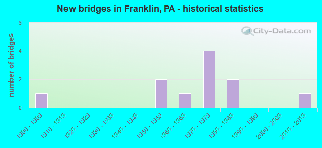
- New bridges - historical statistics
- 11900-1909
- 21950-1959
- 11960-1969
- 41970-1979
- 21980-1989
- 12010-2019

- Reconstructed bridges - Historical Statistics
- 11980-1989
- 01990-1999
- 32000-2009
- 12010-2019
- 12020-2022


- Bridge Condition - Deck
- 62.5%Good
- 25.0%Satisfactory
- 12.5%Serious

- Bridge Condition - Superstructure
- 12.5%Excellent
- 12.5%Very good
- 12.5%Good
- 25.0%Satisfactory
- 25.0%Fair
- 12.5%Serious

- Bridge Condition - Substructure
- 12.5%Very good
- 25.0%Good
- 37.5%Satisfactory
- 12.5%Fair
- 12.5%Serious

- Bridge Condition - Channel
- 12.5%Good
- 62.5%Satisfactory
- 25.0%Fair
Find on map >> Show street view
Structure Number: 33651, Location: VICTORY TOWNSHIP (Lat: 41.326392, Lng: -79.873103), Route carried "on" structure: State highway 8, Year Built: 1975, Year Reconstructed: 2020, Status: Open, Structure Length: 14.42m (47.31ft), Average Daily Traffic: 4,677 (year 2022), Truck Traffic: 10%, Average Future Daily Traffic: 4,207 (year 2032), Design Load: HS 20, Features Intersected: OVER T-370,SANDY CREEK
Minimum Vertical Clearance: 30+ m (98+ ft), Kilometerpoint: 20.432, Lanes on structure: 2, Lanes under structure: 2, Base Highway Network: Yes, Owner: State Highway Agency, Approaching Roadway Width: 11.3m (37.1ft), Skew: 10 degrees, Material/Design: Prestressed concrete, Design/Construction: Stringer/Multi-beam, Number Of Spans In Main Unit: 5, Length of Maximum Span: 28.3m (92.8ft), Curb or Sidewalk Widths: Left: 0.2m (0.7ft), Right: 0.2m (0.7ft), Curb-To-Curb Width: 12.0m (39.4ft), Out-to-Out Width: 13.2m (43.3ft)
Condition: Deck: Satisfactory, Superstructure: Good, Substructure: Satisfactory, Channel: Satisfactory, Operating Rating: 91.6 metric tons, Method Used To Determine Operating Rating: Load and Resistance Factor (LRFR), Inventory Rating: 70.8 metric tons, Method Used To Determine Inventory Rating: Load and Resistance Factor (LRFR), Structural Evaluation: Equal to present minimum criteria, Deck Geometry: Better than present minimum criteria, Underclear: Superior to present desirable criteria, Waterway Adequacy: Superior to present desirable criteria, Approach Roadway Alignment: Equal to present desirable criteria, Length Of Structure Improvement: 15.40m (50.52ft), Designated Inspection Frequency: Every 24 months, Inspection Date: August 2020, Bridge Improvement Cost: $32,000, Roadway Improvement Cost: $94,000, Total Project Cost: $431,000, Deck Structure Type: Concrete Cast-file-Place, Wearing Surface/Protective System: Wearing Surface: Bituminous, Membrane: Other
Find on map >> Show street view
Structure Number: 33653, Location: VICTORY TOWNSHIP (Lat: 41.326169, Lng: -79.874056), Route carried "on" structure: State highway 8, Year Built: 1975, Year Reconstructed: 2000, Status: Open, Structure Length: 12.50m (41.01ft), Average Daily Traffic: 4,639 (year 2022), Truck Traffic: 9%, Average Future Daily Traffic: 4,251 (year 2032), Design Load: HS 20, Features Intersected: OVER T-370,SANDY CREEK
Minimum Vertical Clearance: 30+ m (98+ ft), Kilometerpoint: 20.312, Lanes on structure: 2, Lanes under structure: 2, Base Highway Network: Yes, Owner: State Highway Agency, Approaching Roadway Width: 11.3m (37.1ft), Skew: 10 degrees, Material/Design: Prestressed concrete, Design/Construction: Stringer/Multi-beam, Number Of Spans In Main Unit: 4, Length of Maximum Span: 30.8m (101.0ft), Curb or Sidewalk Widths: Left: 0.2m (0.7ft), Right: 0.2m (0.7ft), Curb-To-Curb Width: 12.0m (39.4ft), Out-to-Out Width: 13.2m (43.3ft)
Condition: Deck: Satisfactory, Superstructure: Satisfactory, Substructure: Satisfactory, Channel: Satisfactory, Operating Rating: 89.8 metric tons, Method Used To Determine Operating Rating: Load Factor (LF), Inventory Rating: 50.8 metric tons, Method Used To Determine Inventory Rating: Load Factor (LF), Structural Evaluation: Equal to present minimum criteria, Deck Geometry: Better than present minimum criteria, Underclear: Superior to present desirable criteria, Waterway Adequacy: Superior to present desirable criteria, Approach Roadway Alignment: Equal to present desirable criteria, Length Of Structure Improvement: 13.40m (43.96ft), Designated Inspection Frequency: Every 24 months, Inspection Date: August 2020, Deck Structure Type: Concrete Cast-file-Place, Wearing Surface/Protective System: Wearing Surface: Bituminous, Membrane: Other
Find on map >> Show street view
Structure Number: 33686, Location: CITY OF FRANKLIN (Lat: 41.395036, Lng: -79.822461), Route carried "on" structure: US 62, Year Built: 1951, Year Reconstructed: 2015, Status: Open, Structure Length: 16.89m (55.41ft), Average Daily Traffic: 11,997 (year 2022), Truck Traffic: 5%, Average Future Daily Traffic: 13,973 (year 2032), Design Load: H 20, Features Intersected: OVER CONRAIL & FRENCH CK
Minimum Vertical Clearance: 30+ m (98+ ft), Kilometerpoint: 18.219, Lanes on structure: 4, Base Highway Network: Yes, Owner: State Highway Agency, Approaching Roadway Width: 16.8m (55.1ft), Skew: 30 degrees, Material/Design: Steel continuous, Design/Construction: Stringer/Multi-beam, Number Of Spans In Main Unit: 4, Number Of Approach Spans: 1, Length of Maximum Span: 38.1m (125.0ft), Curb or Sidewalk Widths: Left: 1.5m (4.9ft), Right: 0.2m (0.7ft), Curb-To-Curb Width: 16.9m (55.4ft), Out-to-Out Width: 19.2m (63.0ft)
Condition: Deck: Good, Superstructure: Fair, Substructure: Fair, Channel: Satisfactory, Operating Rating: 85.3 metric tons, Method Used To Determine Operating Rating: Load Factor (LF), Inventory Rating: 50.8 metric tons, Method Used To Determine Inventory Rating: Load Factor (LF), Structural Evaluation: Somewhat better than minimum adequacy, Deck Geometry: Somewhat better than minimum adequacy, Underclear: High priority of corrective action, Waterway Adequacy: Superior to present desirable criteria, Approach Roadway Alignment: Equal to present minimum criteria, Length Of Structure Improvement: 17.60m (57.74ft), Designated Inspection Frequency: Every 24 months, Inspection Date: August 2020, Bridge Improvement Cost: $156,000, Roadway Improvement Cost: $460,000, Total Project Cost: $2,108,000, Deck Structure Type: Concrete Cast-file-Place, Wearing Surface/Protective System: Wearing Surface: Monolithic Concrete, Deck Protection: Epoxy Coated Reinforcing
Find on map >> Show street view
Structure Number: 33751, Location: CITY OF FRANKLIN (Lat: 41.401511, Lng: -79.830967), Route carried "on" structure: US 322, Year Built: 1969, Year Reconstructed: 2007, Status: Open, Structure Length: 14.90m (48.88ft), Average Daily Traffic: 9,916 (year 2020), Truck Traffic: 4%, Average Future Daily Traffic: 23,065 (year 2032), Design Load: HS 20, Features Intersected: OVER FRENCH CREEK
Minimum Vertical Clearance: 30+ m (98+ ft), Kilometerpoint: 18.926, Lanes on structure: 4, Base Highway Network: Yes, Owner: State Highway Agency, Approaching Roadway Width: 17.1m (56.1ft), Skew: 20 degrees, Material/Design: Steel continuous, Design/Construction: Girder and Floorbeam System, Number Of Spans In Main Unit: 3, Number Of Approach Spans: 1, Length of Maximum Span: 51.5m (169.0ft), Curb or Sidewalk Widths: Left: 2.4m (7.9ft), Right: 2.4m (7.9ft), Curb-To-Curb Width: 17.1m (56.1ft), Out-to-Out Width: 22.7m (74.5ft)
Condition: Deck: Good, Superstructure: Fair, Substructure: Good, Channel: Satisfactory, Operating Rating: 44.5 metric tons, Method Used To Determine Operating Rating: Load Factor (LF), Inventory Rating: 26.3 metric tons, Method Used To Determine Inventory Rating: Load Factor (LF), Structural Evaluation: Somewhat better than minimum adequacy, Deck Geometry: Somewhat better than minimum adequacy, Waterway Adequacy: Superior to present desirable criteria, Approach Roadway Alignment: Equal to present desirable criteria, Length Of Structure Improvement: 15.80m (51.84ft), Designated Inspection Frequency: Every 24 months, Critical Feature Inspection Frequency: Every 24 months, Underwater Inspection Frequency: Every 60 months, Inspection Date: May 2021, Critical Feature Inspection Date: May 2021, Underwater Inspection Date: September 2017, Deck Structure Type: Concrete Cast-file-Place, Wearing Surface/Protective System: Wearing Surface: Latex Concrete
Find on map >> Show street view
Structure Number: 33753, Location: CITY OF FRANKLIN (Lat: 41.389003, Lng: -79.819181), Route carried "on" structure: US 322, Year Built: 1986, Status: Open, Structure Length: 28.10m (92.19ft), Average Daily Traffic: 7,140 (year 2022), Truck Traffic: 7%, Average Future Daily Traffic: 14,637 (year 2032), Design Load: HS 20, Features Intersected: OVER ALLEGHENY RIVER
Minimum Vertical Clearance: 30+ m (98+ ft), Kilometerpoint: 20.315, Lanes on structure: 2, Base Highway Network: Yes, Owner: State Highway Agency, Approaching Roadway Width: 9.1m (29.9ft), Skew: 2 degrees, Material/Design: Prestressed concrete continuous, Design/Construction: Stringer/Multi-beam, Number Of Spans In Main Unit: 9, Length of Maximum Span: 38.1m (125.0ft), Curb or Sidewalk Widths: Left: 1.7m (5.6ft), Right: 0.2m (0.7ft), Curb-To-Curb Width: 9.1m (29.9ft), Out-to-Out Width: 12.0m (39.4ft)
Condition: Deck: Good, Superstructure: Satisfactory, Substructure: Satisfactory, Channel: Satisfactory, Operating Rating: 88.9 metric tons, Method Used To Determine Operating Rating: Load Factor (LF), Inventory Rating: 43.5 metric tons, Method Used To Determine Inventory Rating: Load Factor (LF), Structural Evaluation: Equal to present minimum criteria, Deck Geometry: Meets minimum limits, Waterway Adequacy: Superior to present desirable criteria, Approach Roadway Alignment: Better than present minimum criteria, Length Of Structure Improvement: 28.50m (93.50ft), Designated Inspection Frequency: Every 48 months, Underwater Inspection Frequency: Every 60 months, Inspection Date: July 2019, Underwater Inspection Date: April 2021, Deck Structure Type: Concrete Cast-file-Place, Wearing Surface/Protective System: Wearing Surface: Bituminous, Membrane: Preformed Fabric, Deck Protection: Epoxy Coated Reinforcing
Find on map >> Show street view
Structure Number: 33754, Location: CRANBERRY TOWNSHIP (Lat: 41.373842, Lng: -79.800872), Route carried "on" structure: US 322, Year Built: 1981, Status: Open, Structure Length: 0.70m (2.30ft), Average Daily Traffic: 7,285 (year 2021), Truck Traffic: 7%, Average Future Daily Traffic: 10,250 (year 2032), Design Load: H 20, Features Intersected: OVER LOWER TWO MILE RUN
Minimum Vertical Clearance: 30+ m (98+ ft), Kilometerpoint: 23.385, Lanes on structure: 2, Base Highway Network: Yes, Owner: State Highway Agency, Approaching Roadway Width: 10.4m (34.1ft), Skew: 3 degrees, Material/Design: Steel, Design/Construction: Culvert, Number Of Spans In Main Unit: 1, Length of Maximum Span: 7.0m (23.0ft), Curb-To-Curb Width: 14.0m (45.9ft), Out-to-Out Width: 14.6m (47.9ft)
Condition: Channel: Good, Culverts: Satisfactory, Operating Rating: 49.0 metric tons, Method Used To Determine Operating Rating: Field evaluation and documented engineering judgment, Inventory Rating: 32.7 metric tons, Method Used To Determine Inventory Rating: Field evaluation and documented engineering judgment, Structural Evaluation: Equal to present minimum criteria, Deck Geometry: Superior to present desirable criteria, Waterway Adequacy: Equal to present desirable criteria, Approach Roadway Alignment: Equal to present desirable criteria, Length Of Structure Improvement: 0.70m (2.30ft), Designated Inspection Frequency: Every 48 months, Inspection Date: April 2020
Find on map >> Show street view
Structure Number: 33833, Location: CRANBERRY TOWNSHIP (Lat: 41.376667, Lng: -79.798833), Route carried "on" structure: State highway , Year Built: 1957, Year Reconstructed: 2009, Status: Open, Structure Length: 1.65m (5.41ft), Average Daily Traffic: 455 (year 2021), Truck Traffic: 10%, Average Future Daily Traffic: 1,111 (year 2032), Design Load: HS 20, Features Intersected: OVER LOWER TWO MILE RUN, Facility Carried by Structure: SR 3025,DEEP HOLLW
Minimum Vertical Clearance: 30+ m (98+ ft), Kilometerpoint: 0.000, Lanes on structure: 2, Owner: State Highway Agency, Approaching Roadway Width: 8.8m (28.9ft), Skew: 4 degrees, Material/Design: Prestressed concrete, Design/Construction: Box Beam or Girders - Single/Spread, Number Of Spans In Main Unit: 1, Length of Maximum Span: 15.8m (51.8ft), Curb-To-Curb Width: 9.2m (30.2ft), Out-to-Out Width: 10.1m (33.1ft)
Condition: Deck: Good, Superstructure: Excellent, Substructure: Good, Channel: Fair, Operating Rating: 59.9 metric tons, Method Used To Determine Operating Rating: Load and Resistance Factor (LRFR), Inventory Rating: 43.5 metric tons, Method Used To Determine Inventory Rating: Load and Resistance Factor (LRFR), Structural Evaluation: Better than present minimum criteria, Deck Geometry: Equal to present minimum criteria, Waterway Adequacy: High priority of corrective action, Approach Roadway Alignment: Equal to present desirable criteria, Length Of Structure Improvement: 2.40m (7.87ft), Designated Inspection Frequency: Every 48 months, Inspection Date: November 2019, Bridge Improvement Cost: $3,000, Roadway Improvement Cost: $8,000, Total Project Cost: $37,000, Deck Structure Type: Concrete Cast-file-Place, Wearing Surface/Protective System: Wearing Surface: Monolithic Concrete, Deck Protection: Epoxy Coated Reinforcing
Find on map >> Show street view
Structure Number: 33931, Location: 1 MI. E. OF OLD RT. 8 (Lat: 41.325872, Lng: -79.874403), Route carried "on" structure: City street 7220, Year Built: 1907, Year Reconstructed: 1991, Status: Posted for load, Structure Length: 2.59m (8.50ft), Average Daily Traffic: 50 (year 2015), Average Future Daily Traffic: 70 (year 2035), Design Load: H 15, Features Intersected: VICTORY RUN, Facility Carried by Structure: T-370 - FISHERMANS
Minimum Vertical Clearance: 4.11m (13.48ft), Kilometerpoint: 0.000, Lanes on structure: 1, Owner: Town or Township Highway Agency, Approaching Roadway Width: 3.7m (12.1ft), Material/Design: Steel, Design/Construction: Stringer/Multi-beam, Number Of Spans In Main Unit: 2, Length of Maximum Span: 11.9m (39.0ft), Curb-To-Curb Width: 3.9m (12.8ft), Out-to-Out Width: 4.7m (15.4ft)
Condition: Deck: Serious, Superstructure: Serious, Substructure: Serious, Channel: Fair, Inventory Rating: 99.8 metric tons, Method Used To Determine Inventory Rating: Load Factor (LF), Structural Evaluation: High priority of corrective action, Deck Geometry: High priority of corrective action, Waterway Adequacy: Better than present minimum criteria, Approach Roadway Alignment: Equal to present desirable criteria, Length Of Structure Improvement: 2.60m (8.53ft), Designated Inspection Frequency: Every 24 months, Critical Feature Inspection Frequency: Every 12 months, Other Special Inspection Frequency: Every 3 months, Inspection Date: March 2020, Critical Feature Inspection Date: September 2021, Other Special Inspection Date: September 2021, Bridge Improvement Cost: $33,000, Roadway Improvement Cost: $208,000, Total Project Cost: $449,000, Deck Structure Type: Wood or Timber
Find on map >> Show street view
Structure Number: 46887, Location: FRANKLIN BOROUGH (Lat: 40.343156, Lng: -78.884958), Route carried "on" structure: State highway , Year Built: 2011, Status: Open, Structure Length: 2.74m (8.99ft), Average Daily Traffic: 3,949 (year 2022), Truck Traffic: 6%, Average Future Daily Traffic: 4,812 (year 2032), Design Load: HL 93, Features Intersected: LEHIGH VALLEY RAILROAD, Facility Carried by Structure: SR 3029
Minimum Vertical Clearance: 30+ m (98+ ft), Kilometerpoint: 5.868, Lanes on structure: 2, Owner: State Highway Agency, Approaching Roadway Width: 9.4m (30.8ft), Skew: 1 degrees, Material/Design: Steel continuous, Design/Construction: Stringer/Multi-beam, Number Of Spans In Main Unit: 1, Length of Maximum Span: 27.1m (88.9ft), Curb or Sidewalk Widths: Left: 0.2m (0.7ft), Right: 1.8m (5.9ft), Curb-To-Curb Width: 9.5m (31.2ft), Out-to-Out Width: 12.1m (39.7ft)
Condition: Deck: Good, Superstructure: Very good, Substructure: Very good, Operating Rating: 66.4 metric tons, Method Used To Determine Operating Rating: Assigned ratings based on Load and Resistance Factor Design (LRFD) reported by rating factor (RF) using HL93 loadings, Inventory Rating: 41.5 metric tons, Method Used To Determine Inventory Rating: Assigned ratings based on Load and Resistance Factor Design (LRFD) reported by rating factor (RF) using HL93 loadings, Structural Evaluation: Equal to present desirable criteria, Deck Geometry: Meets minimum limits, Underclear: High priority of corrective action, Approach Roadway Alignment: Equal to present desirable criteria, Designated Inspection Frequency: Every 48 months, Inspection Date: March 2020, Deck Structure Type: Concrete Cast-file-Place, Wearing Surface/Protective System: Wearing Surface: Epoxy Overlay, Deck Protection: Epoxy Coated Reinforcing
Find on map >> Show street view
Structure Number: 33651, Location: VICTORY TOWNSHIP (Lat: 41.326392, Lng: -79.873103), Route carried "under" structure: City street 7220, Year Built: 1975, Structure Length: 0. m, Average Daily Traffic: 50 (year 2002), Features Intersected: OVER T-370,SANDY CREEK, Facility Carried by Structure: SR 8,R C FRAME HWY
Minimum Vertical Clearance: 15.24m (50.00ft), Kilometerpoint: 0.000, Lanes on structure: 2, Lanes under structure: 2, Material/Design: Prestressed concrete, Design/Construction: Stringer/Multi-beam, Length of Maximum Span: 28.3m (92.8ft)
Find on map >> Show street view
Structure Number: 33653, Location: VICTORY TOWNSHIP (Lat: 41.326169, Lng: -79.874056), Route carried "under" structure: City street 7220, Year Built: 1975, Structure Length: 0. m, Average Daily Traffic: 50 (year 2002), Features Intersected: OVER T-370,SANDY CREEK, Facility Carried by Structure: SR 8,R C FRAME HWY
Minimum Vertical Clearance: 18.85m (61.84ft), Kilometerpoint: 0.000, Lanes on structure: 2, Lanes under structure: 2, Material/Design: Prestressed concrete, Design/Construction: Stringer/Multi-beam, Length of Maximum Span: 30.8m (101.0ft)