Bridge Statistics for Franklin, Massachusetts (MA)
Condition, Traffic, Stress, Structural Evaluation, Project Costs
- National Bridge Inventory (NBI) Statistics
- 27Number of bridges
- 213ft / 65.2mTotal length
- $43,850,000Total costs
- 717,743Total average daily traffic
- 42,394Total average daily truck traffic
- National Bridge Inventory (NBI) Registered Bridges for Franklin
- No street view available for this location
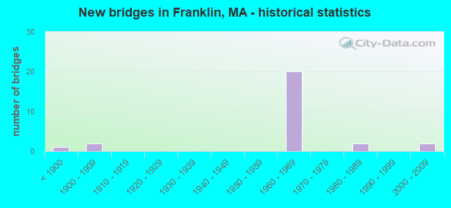
- New bridges - historical statistics
- 1Before 1900
- 21900-1909
- 201960-1969
- 21980-1989
- 22000-2009

- Reconstructed bridges - Historical Statistics
- 11900-1909
- 01910-1919
- 01920-1929
- 01930-1939
- 01940-1949
- 01950-1959
- 01960-1969
- 01970-1979
- 01980-1989
- 11990-1999


- Bridge Condition - Deck
- 25.0%Good
- 56.3%Satisfactory
- 18.8%Fair

- Bridge Condition - Superstructure
- 16.7%Good
- 50.0%Satisfactory
- 33.3%Fair

- Bridge Condition - Substructure
- 50.0%Good
- 27.8%Satisfactory
- 22.2%Fair

- Bridge Condition - Channel
- 20.0%Good
- 20.0%Satisfactory
- 60.0%Fair
Find on map >> Show street view
Structure Number: F080062AYDOT634, Location: .8 MI SW OF NORFOLK T.L. (Lat: 42.098286, Lng: -71.373117), Route carried "on" structure: City street , Year Built: 1981, Status: Open, Structure Length: 2.47m (8.10ft), Average Daily Traffic: 4,000 (year 2013), Truck Traffic: 4%, Average Future Daily Traffic: 6,317 (year 2032), Design Load: HS 20+Mod, Features Intersected: RR MBTA/CSX, Facility Carried by Structure: HWY CHESTNUT ST
Minimum Vertical Clearance: 30+ m (98+ ft), Kilometerpoint: 2.414, Lanes on structure: 2, Owner: State Highway Agency, Approaching Roadway Width: 12.2m (40.0ft), Skew: 5 degrees, Material/Design: Steel, Design/Construction: Stringer/Multi-beam, Number Of Spans In Main Unit: 1, Length of Maximum Span: 22.9m (75.1ft), Curb or Sidewalk Widths: Left: 2.0m (6.6ft), Right: 0.6m (2.0ft), Curb-To-Curb Width: 12.2m (40.0ft), Out-to-Out Width: 14.7m (48.2ft)
Condition: Deck: Good, Superstructure: Fair, Substructure: Good, Operating Rating: 76.3 metric tons, Method Used To Determine Operating Rating: Load Factor (LF), Inventory Rating: 45.7 metric tons, Method Used To Determine Inventory Rating: Load Factor (LF), Structural Evaluation: Somewhat better than minimum adequacy, Deck Geometry: Equal to present minimum criteria, Underclear: Meets minimum limits, Approach Roadway Alignment: Better than present minimum criteria, Length Of Structure Improvement: 2.50m (8.20ft), Designated Inspection Frequency: Every 24 months, Inspection Date: November 2021, Bridge Improvement Cost: $1,444,000, Roadway Improvement Cost: $145,000, Total Project Cost: $2,167,000 ( Estimate for 2022), Deck Structure Type: Concrete Cast-file-Place, Wearing Surface/Protective System: Wearing Surface: Bituminous, Membrane: Built-up
Find on map >> Show street view
Structure Number: F080072B0DOT634, Location: 0.1 MI WEST OF SUMMER ST (Lat: 42.082575, Lng: -71.397081), Route carried "on" structure: State highway 140, Year Built: 1899, Year Reconstructed: 1995, Status: Open, Structure Length: 0.85m (2.79ft), Average Daily Traffic: 31,200 (year 2012), Truck Traffic: 5%, Average Future Daily Traffic: 49,274 (year 2031), Design Load: HS 20, Features Intersected: RR MBTA/CSX
Minimum Vertical Clearance: 30+ m (98+ ft), Kilometerpoint: 78.513, Lanes on structure: 4, Base Highway Network: Yes, Owner: State Highway Agency, Approaching Roadway Width: 14.0m (45.9ft), Skew: 33 degrees, Material/Design: Prestressed concrete, Design/Construction: Slab, Number Of Spans In Main Unit: 1, Length of Maximum Span: 7.6m (24.9ft), Curb or Sidewalk Widths: Left: 2.1m (6.9ft), Right: 1.5m (4.9ft), Curb-To-Curb Width: 13.9m (45.6ft), Out-to-Out Width: 35.7m (117.1ft)
Condition: Deck: Satisfactory, Superstructure: Satisfactory, Substructure: Good, Inventory Rating: 69.5 metric tons, Method Used To Determine Inventory Rating: Load Factor (LF), Structural Evaluation: Equal to present minimum criteria, Deck Geometry: High priority of replacement, Underclear: High priority of corrective action, Approach Roadway Alignment: Better than present minimum criteria, Length Of Structure Improvement: 0.90m (2.95ft), Designated Inspection Frequency: Every 24 months, Inspection Date: November 2020, Bridge Improvement Cost: $696,000, Roadway Improvement Cost: $70,000, Total Project Cost: $1,045,000 ( Estimate for 2022), Deck Structure Type: Concrete Precast Panels, Wearing Surface/Protective System: Wearing Surface: Bituminous, Membrane: Built-up, Deck Protection: Epoxy Coated Reinforcing
Find on map >> Show street view
Structure Number: F080082A3MUNNBI, Location: CHRLS. RIVER @ MDWY. T.L. (Lat: 42.138328, Lng: -71.398364), Route carried "on" structure: City street , Year Built: 1900, Year Reconstructed: 1911, Status: Open, Structure Length: 1.07m (3.51ft), Average Daily Traffic: 3,000 (year 2014), Truck Traffic: 6%, Average Future Daily Traffic: 4,738 (year 2031), Features Intersected: WATER CHARLES RIVER, Facility Carried by Structure: HWY LINCOLN ST
Minimum Vertical Clearance: 30+ m (98+ ft), Kilometerpoint: 5.375, Lanes on structure: 2, Owner: Town or Township Highway Agency, Approaching Roadway Width: 8.5m (27.9ft), Material/Design: Concrete, Design/Construction: Arch - Deck, Number Of Spans In Main Unit: 1, Length of Maximum Span: 10.7m (35.1ft), Curb-To-Curb Width: 8.5m (27.9ft), Out-to-Out Width: 9.1m (29.9ft)
Condition: Superstructure: Satisfactory, Substructure: Satisfactory, Channel: Good, Inventory Rating: 67.2 metric tons, Method Used To Determine Inventory Rating: Load Factor (LF), Structural Evaluation: Equal to present minimum criteria, Deck Geometry: Meets minimum limits, Waterway Adequacy: Equal to present desirable criteria, Approach Roadway Alignment: Somewhat better than minimum adequacy, Length Of Structure Improvement: 1.10m (3.61ft), Designated Inspection Frequency: Every 24 months, Inspection Date: May 2020, Bridge Improvement Cost: $509,000, Roadway Improvement Cost: $51,000, Total Project Cost: $764,000 ( Estimate for 2022)
Find on map >> Show street view
Structure Number: F080092AAMUNNBI, Location: .3 MI S OF VILLAGE RD (Lat: 42.136517, Lng: -71.418511), Route carried "on" structure: City street , Year Built: 1900, Status: Open, Structure Length: 1.04m (3.41ft), Average Daily Traffic: 1,300 (year 2016), Truck Traffic: 1%, Average Future Daily Traffic: 2,053 (year 2031), Features Intersected: WATER CHARLES RIVER, Facility Carried by Structure: HWY ELM ST
Minimum Vertical Clearance: 30+ m (98+ ft), Kilometerpoint: 1.609, Lanes on structure: 2, Owner: Town or Township Highway Agency, Approaching Roadway Width: 5.5m (18.0ft), Material/Design: Masonry, Design/Construction: Arch - Deck, Number Of Spans In Main Unit: 1, Length of Maximum Span: 9.4m (30.8ft), Curb-To-Curb Width: 6.8m (22.3ft), Out-to-Out Width: 7.6m (24.9ft)
Condition: Superstructure: Fair, Substructure: Fair, Channel: Fair, Operating Rating: 53.1 metric tons, Method Used To Determine Operating Rating: Allowable Stress (AS), Inventory Rating: 41.4 metric tons, Method Used To Determine Inventory Rating: Allowable Stress (AS), Structural Evaluation: Somewhat better than minimum adequacy, Deck Geometry: High priority of corrective action, Waterway Adequacy: Equal to present desirable criteria, Approach Roadway Alignment: Better than present minimum criteria, Length Of Structure Improvement: 1.10m (3.61ft), Designated Inspection Frequency: Every 24 months, Underwater Inspection Frequency: Every 36 months, Inspection Date: May 2020, Underwater Inspection Date: January 2020, Bridge Improvement Cost: $329,000, Roadway Improvement Cost: $33,000, Total Project Cost: $494,000 ( Estimate for 2022)
Find on map >> Show street view
Structure Number: F080167WJMUNNBI, Location: @ INST. OF ROBIN HOOD LN (Lat: 42.055747, Lng: -71.409844), Route carried "on" structure: City street , Year Built: 1989, Status: Open, Structure Length: 0.65m (2.13ft), Average Daily Traffic: 2,160 (year 2014), Truck Traffic: 1%, Design Load: HS 20, Features Intersected: WATER DIX BROOK, Facility Carried by Structure: HWY FOREST ST
Minimum Vertical Clearance: 30+ m (98+ ft), Kilometerpoint: 0.000, Lanes on structure: 2, Owner: Town or Township Highway Agency, Approaching Roadway Width: 8.6m (28.2ft), Material/Design: Concrete, Design/Construction: Culvert, Number Of Spans In Main Unit: 2, Length of Maximum Span: 3.0m (9.8ft), Curb-To-Curb Width: 8.6m (28.2ft), Out-to-Out Width: 10.3m (33.8ft)
Condition: Channel: Fair, Culverts: Satisfactory, Operating Rating: 51.8 metric tons, Method Used To Determine Operating Rating: Load Factor (LF), Inventory Rating: 31.1 metric tons, Method Used To Determine Inventory Rating: Load Factor (LF), Structural Evaluation: Equal to present minimum criteria, Deck Geometry: Meets minimum limits, Waterway Adequacy: Better than present minimum criteria, Approach Roadway Alignment: Somewhat better than minimum adequacy, Length Of Structure Improvement: 0.90m (2.95ft), Designated Inspection Frequency: Every 24 months, Inspection Date: June 2020, Bridge Improvement Cost: $229,000, Roadway Improvement Cost: $23,000, Total Project Cost: $344,000 ( Estimate for 2022)
Find on map >> Show street view
Structure Number: F080202ABMUNNBI, Location: 0.2 MI. W. OF RT. 495 (Lat: 42.086989, Lng: -71.427167), Route carried "on" structure: City street , Year Built: 1961, Status: Open, Structure Length: 1.74m (5.71ft), Average Daily Traffic: 8,864 (year 2018), Truck Traffic: 5%, Average Future Daily Traffic: 11,845 (year 2032), Design Load: H 20, Features Intersected: WATER MINE BROOK, Facility Carried by Structure: HWY GROVE ST
Minimum Vertical Clearance: 30+ m (98+ ft), Kilometerpoint: 3.766, Lanes on structure: 2, Owner: Town or Township Highway Agency, Approaching Roadway Width: 10.4m (34.1ft), Material/Design: Concrete continuous, Design/Construction: Slab, Number Of Spans In Main Unit: 3, Length of Maximum Span: 5.5m (18.0ft), Curb or Sidewalk Widths: Left: 0.3m (1.0ft), Right: 0.3m (1.0ft), Curb-To-Curb Width: 10.4m (34.1ft), Out-to-Out Width: 11.7m (38.4ft)
Condition: Deck: Satisfactory, Superstructure: Satisfactory, Substructure: Fair, Channel: Fair, Operating Rating: 44.7 metric tons, Method Used To Determine Operating Rating: Load Factor (LF), Inventory Rating: 26.8 metric tons, Method Used To Determine Inventory Rating: Load Factor (LF), Structural Evaluation: Somewhat better than minimum adequacy, Deck Geometry: Meets minimum limits, Waterway Adequacy: Equal to present desirable criteria, Approach Roadway Alignment: Better than present minimum criteria, Length Of Structure Improvement: 1.80m (5.91ft), Designated Inspection Frequency: Every 24 months, Inspection Date: Febuary 2021, Bridge Improvement Cost: $828,000, Roadway Improvement Cost: $83,000, Total Project Cost: $1,243,000 ( Estimate for 2022), Deck Structure Type: Concrete Cast-file-Place, Wearing Surface/Protective System: Wearing Surface: Bituminous, Membrane: Built-up
Find on map >> Show street view
Structure Number: F080211V8DOTNBI, Location: .8 MI NW OF KING ST (Lat: 42.072453, Lng: -71.412481), Route carried "on" structure: Interstate 495, Year Built: 1966, Status: Open, Structure Length: 3.41m (11.19ft), Average Daily Traffic: 43,628 (year 2015), Truck Traffic: 6%, Average Future Daily Traffic: 109,603 (year 2032), Design Load: H 20, Features Intersected: RR CSX
Minimum Vertical Clearance: 30+ m (98+ ft), Kilometerpoint: 67.188, Lanes on structure: 3, Base Highway Network: Yes, Owner: State Highway Agency, Approaching Roadway Width: 14.9m (48.9ft), Material/Design: Steel, Design/Construction: Stringer/Multi-beam, Number Of Spans In Main Unit: 3, Length of Maximum Span: 11.6m (38.1ft), Curb-To-Curb Width: 15.0m (49.2ft), Out-to-Out Width: 16.7m (54.8ft)
Condition: Deck: Satisfactory, Superstructure: Satisfactory, Substructure: Good, Operating Rating: 53.5 metric tons, Method Used To Determine Operating Rating: Load Factor (LF), Inventory Rating: 32.0 metric tons, Method Used To Determine Inventory Rating: Load Factor (LF), Structural Evaluation: Equal to present minimum criteria, Deck Geometry: Meets minimum limits, Underclear: Equal to present minimum criteria, Approach Roadway Alignment: Equal to present desirable criteria, Length Of Structure Improvement: 3.50m (11.48ft), Designated Inspection Frequency: Every 24 months, Inspection Date: January 2021, Bridge Improvement Cost: $2,296,000, Roadway Improvement Cost: $230,000, Total Project Cost: $3,445,000 ( Estimate for 2022), Deck Structure Type: Concrete Cast-file-Place, Wearing Surface/Protective System: Wearing Surface: Bituminous, Membrane: Built-up
Find on map >> Show street view
Structure Number: F080211V9DOTNBI, Location: .8 MI N OF KING ST (Lat: 42.072694, Lng: -71.412131), Route carried "on" structure: Interstate 495, Year Built: 1966, Status: Open, Structure Length: 3.41m (11.19ft), Average Daily Traffic: 43,890 (year 2016), Truck Traffic: 6%, Average Future Daily Traffic: 109,603 (year 2032), Design Load: H 20, Features Intersected: RR CSX
Minimum Vertical Clearance: 30+ m (98+ ft), Kilometerpoint: 67.188, Lanes on structure: 3, Base Highway Network: Yes, Owner: State Highway Agency, Approaching Roadway Width: 14.9m (48.9ft), Material/Design: Steel, Design/Construction: Stringer/Multi-beam, Number Of Spans In Main Unit: 3, Length of Maximum Span: 11.6m (38.1ft), Curb-To-Curb Width: 15.0m (49.2ft), Out-to-Out Width: 16.7m (54.8ft)
Condition: Deck: Fair, Superstructure: Satisfactory, Substructure: Good, Operating Rating: 53.5 metric tons, Method Used To Determine Operating Rating: Load Factor (LF), Inventory Rating: 32.1 metric tons, Method Used To Determine Inventory Rating: Load Factor (LF), Structural Evaluation: Equal to present minimum criteria, Deck Geometry: Meets minimum limits, Underclear: Equal to present minimum criteria, Approach Roadway Alignment: Equal to present desirable criteria, Length Of Structure Improvement: 3.50m (11.48ft), Designated Inspection Frequency: Every 24 months, Inspection Date: January 2021, Bridge Improvement Cost: $2,296,000, Roadway Improvement Cost: $230,000, Total Project Cost: $3,445,000 ( Estimate for 2022), Deck Structure Type: Concrete Cast-file-Place, Wearing Surface/Protective System: Wearing Surface: Bituminous, Membrane: Built-up
Find on map >> Show street view
Structure Number: F080222AQDOTNBI, Location: AT M.M.041.646 ON I-495 (Lat: 42.070522, Lng: -71.409383), Route carried "on" structure: City street , Year Built: 1966, Status: Open, Structure Length: 7.38m (24.21ft), Average Daily Traffic: 1,300 (year 2013), Truck Traffic: 3%, Average Future Daily Traffic: 2,053 (year 2032), Design Load: H 20, Features Intersected: I 495, Facility Carried by Structure: HWY WASHNGTON ST
Minimum Vertical Clearance: 30+ m (98+ ft), Kilometerpoint: 1.288, Lanes on structure: 2, Lanes under structure: 6, Owner: State Highway Agency, Approaching Roadway Width: 12.2m (40.0ft), Material/Design: Steel, Design/Construction: Stringer/Multi-beam, Number Of Spans In Main Unit: 3, Length of Maximum Span: 26.8m (87.9ft), Curb or Sidewalk Widths: Left: 1.8m (5.9ft), Right: 1.8m (5.9ft), Curb-To-Curb Width: 12.2m (40.0ft), Out-to-Out Width: 16.7m (54.8ft)
Condition: Deck: Good, Superstructure: Satisfactory, Substructure: Good, Operating Rating: 51.1 metric tons, Method Used To Determine Operating Rating: Load Factor (LF), Inventory Rating: 30.6 metric tons, Method Used To Determine Inventory Rating: Load Factor (LF), Structural Evaluation: Equal to present minimum criteria, Deck Geometry: Better than present minimum criteria, Underclear: High priority of corrective action, Approach Roadway Alignment: Equal to present desirable criteria, Length Of Structure Improvement: 7.40m (24.28ft), Designated Inspection Frequency: Every 24 months, Inspection Date: June 2021, Bridge Improvement Cost: $4,855,000, Roadway Improvement Cost: $486,000, Total Project Cost: $7,283,000 ( Estimate for 2022), Deck Structure Type: Concrete Cast-file-Place, Wearing Surface/Protective System: Wearing Surface: Bituminous, Membrane: Built-up
Find on map >> Show street view
Structure Number: F080231VADOTNBI, Location: I-495 @ EXIT 16 (Lat: 42.065056, Lng: -71.400903), Route carried "on" structure: Interstate 495, Year Built: 1966, Status: Open, Structure Length: 2.71m (8.89ft), Average Daily Traffic: 42,890 (year 2020), Truck Traffic: 15%, Average Future Daily Traffic: 63,172 (year 2032), Design Load: H 20, Features Intersected: HWY KING ST
Minimum Vertical Clearance: 30+ m (98+ ft), Kilometerpoint: 65.981, Lanes on structure: 4, Lanes under structure: 4, Base Highway Network: Yes, Owner: State Highway Agency, Approaching Roadway Width: 15.2m (49.9ft), Material/Design: Steel, Design/Construction: Stringer/Multi-beam, Number Of Spans In Main Unit: 1, Length of Maximum Span: 25.6m (84.0ft), Curb-To-Curb Width: 15.0m (49.2ft), Out-to-Out Width: 16.7m (54.8ft)
Condition: Deck: Good, Superstructure: Good, Substructure: Good, Operating Rating: 48.8 metric tons, Method Used To Determine Operating Rating: Allowable Stress (AS), Inventory Rating: 27.9 metric tons, Method Used To Determine Inventory Rating: Allowable Stress (AS), Structural Evaluation: Better than present minimum criteria, Deck Geometry: High priority of replacement, Underclear: Meets minimum limits, Approach Roadway Alignment: Equal to present desirable criteria, Length Of Structure Improvement: 2.80m (9.19ft), Designated Inspection Frequency: Every 24 months, Inspection Date: May 2021, Bridge Improvement Cost: $1,837,000, Roadway Improvement Cost: $184,000, Total Project Cost: $2,756,000 ( Estimate for 2022), Deck Structure Type: Concrete Cast-file-Place, Wearing Surface/Protective System: Wearing Surface: Bituminous, Membrane: Built-up
Find on map >> Show street view
Structure Number: F080231VBDOTNBI, Location: I-495 @ EXIT 16 (Lat: 42.064650, Lng: -71.401283), Route carried "on" structure: Interstate 495, Year Built: 1966, Status: Open, Structure Length: 2.71m (8.89ft), Average Daily Traffic: 33,852 (year 2020), Truck Traffic: 15%, Average Future Daily Traffic: 71,068 (year 2032), Design Load: HS 20+Mod, Features Intersected: HWY KING ST
Minimum Vertical Clearance: 30+ m (98+ ft), Kilometerpoint: 65.981, Lanes on structure: 3, Lanes under structure: 4, Base Highway Network: Yes, Owner: State Highway Agency, Approaching Roadway Width: 15.2m (49.9ft), Material/Design: Steel, Design/Construction: Stringer/Multi-beam, Number Of Spans In Main Unit: 1, Length of Maximum Span: 25.6m (84.0ft), Curb-To-Curb Width: 15.0m (49.2ft), Out-to-Out Width: 16.7m (54.8ft)
Condition: Deck: Good, Superstructure: Good, Substructure: Good, Operating Rating: 48.8 metric tons, Method Used To Determine Operating Rating: Allowable Stress (AS), Inventory Rating: 27.9 metric tons, Method Used To Determine Inventory Rating: Allowable Stress (AS), Structural Evaluation: Better than present minimum criteria, Deck Geometry: Meets minimum limits, Underclear: Meets minimum limits, Approach Roadway Alignment: Equal to present desirable criteria, Length Of Structure Improvement: 2.80m (9.19ft), Designated Inspection Frequency: Every 24 months, Inspection Date: May 2021, Bridge Improvement Cost: $1,837,000, Roadway Improvement Cost: $184,000, Total Project Cost: $2,756,000 ( Estimate for 2022), Deck Structure Type: Concrete Cast-file-Place, Wearing Surface/Protective System: Wearing Surface: Bituminous, Membrane: Built-up
Find on map >> Show street view
Structure Number: F080241VCDOTNBI, Location: .3 MI NW OF WRENTHAM T.L. (Lat: 42.058403, Lng: -71.383844), Route carried "on" structure: Interstate 495, Year Built: 1966, Status: Open, Structure Length: 2.83m (9.28ft), Average Daily Traffic: 44,280 (year 2018), Truck Traffic: 6%, Average Future Daily Traffic: 60,013 (year 2032), Design Load: H 20, Features Intersected: HWY SUMMER ST
Minimum Vertical Clearance: 30+ m (98+ ft), Kilometerpoint: 64.533, Lanes on structure: 4, Lanes under structure: 2, Base Highway Network: Yes, Owner: State Highway Agency, Approaching Roadway Width: 15.2m (49.9ft), Skew: 3 degrees, Material/Design: Steel, Design/Construction: Stringer/Multi-beam, Number Of Spans In Main Unit: 1, Length of Maximum Span: 26.8m (87.9ft), Curb-To-Curb Width: 15.0m (49.2ft), Out-to-Out Width: 16.6m (54.5ft)
Condition: Deck: Satisfactory, Superstructure: Fair, Substructure: Fair, Operating Rating: 50.6 metric tons, Method Used To Determine Operating Rating: Allowable Stress (AS), Inventory Rating: 30.1 metric tons, Method Used To Determine Inventory Rating: Allowable Stress (AS), Structural Evaluation: Somewhat better than minimum adequacy, Deck Geometry: High priority of replacement, Underclear: High priority of corrective action, Approach Roadway Alignment: Equal to present desirable criteria, Length Of Structure Improvement: 2.90m (9.51ft), Designated Inspection Frequency: Every 24 months, Inspection Date: August 2021, Bridge Improvement Cost: $1,891,000, Roadway Improvement Cost: $190,000, Total Project Cost: $2,837,000 ( Estimate for 2022), Deck Structure Type: Concrete Cast-file-Place, Wearing Surface/Protective System: Wearing Surface: Bituminous, Membrane: Built-up
Find on map >> Show street view
Structure Number: F080241VDDOTNBI, Location: .3 MI NW OF WRNTHM T.L. (Lat: 42.057611, Lng: -71.383731), Route carried "on" structure: Interstate 495, Year Built: 1966, Status: Open, Structure Length: 2.91m (9.55ft), Average Daily Traffic: 34,276 (year 2020), Truck Traffic: 6%, Average Future Daily Traffic: 57,565 (year 2032), Design Load: HS 20+Mod, Features Intersected: HWY SUMMER ST
Minimum Vertical Clearance: 30+ m (98+ ft), Kilometerpoint: 64.533, Lanes on structure: 3, Lanes under structure: 2, Base Highway Network: Yes, Owner: State Highway Agency, Approaching Roadway Width: 15.7m (51.5ft), Skew: 3 degrees, Material/Design: Steel, Design/Construction: Stringer/Multi-beam, Number Of Spans In Main Unit: 1, Length of Maximum Span: 27.6m (90.6ft), Curb-To-Curb Width: 15.7m (51.5ft), Out-to-Out Width: 16.7m (54.8ft)
Condition: Deck: Satisfactory, Superstructure: Fair, Substructure: Satisfactory, Operating Rating: 50.4 metric tons, Method Used To Determine Operating Rating: Allowable Stress (AS), Inventory Rating: 26.9 metric tons, Method Used To Determine Inventory Rating: Allowable Stress (AS), Structural Evaluation: Somewhat better than minimum adequacy, Deck Geometry: Somewhat better than minimum adequacy, Underclear: High priority of corrective action, Approach Roadway Alignment: Equal to present desirable criteria, Length Of Structure Improvement: 3.00m (9.84ft), Designated Inspection Frequency: Every 24 months, Inspection Date: August 2021, Bridge Improvement Cost: $1,968,000, Roadway Improvement Cost: $197,000, Total Project Cost: $2,953,000 ( Estimate for 2022), Deck Structure Type: Concrete Cast-file-Place, Wearing Surface/Protective System: Wearing Surface: Bituminous, Membrane: Built-up
Find on map >> Show street view
Structure Number: F08026ANWDOTNBI, Location: 3 MI S OF ST-126 (Lat: 42.090114, Lng: -71.427222), Route carried "on" structure: State highway 140, Year Built: 2006, Status: Open, Structure Length: 7.12m (23.36ft), Average Daily Traffic: 23,625 (year 2020), Truck Traffic: 10%, Average Future Daily Traffic: 39,482 (year 2031), Design Load: HS 20+Mod, Features Intersected: I 495
Minimum Vertical Clearance: 99.00m (324.80ft), Kilometerpoint: 78.513, Lanes on structure: 6, Lanes under structure: 6, Owner: State Highway Agency, Approaching Roadway Width: 28.0m (91.9ft), Skew: 31 degrees, Material/Design: Steel continuous, Design/Construction: Stringer/Multi-beam, Number Of Spans In Main Unit: 2, Length of Maximum Span: 35.4m (116.1ft), Curb or Sidewalk Widths: Left: 1.8m (5.9ft), Right: 0.0m, Curb-To-Curb Width: 28.0m (91.9ft), Out-to-Out Width: 32.5m (106.6ft)
Condition: Deck: Satisfactory, Superstructure: Satisfactory, Substructure: Good, Operating Rating: 73.7 metric tons, Method Used To Determine Operating Rating: Load Factor (LF), Inventory Rating: 44.1 metric tons, Method Used To Determine Inventory Rating: Load Factor (LF), Structural Evaluation: Equal to present minimum criteria, Deck Geometry: Superior to present desirable criteria, Underclear: Equal to present minimum criteria, Approach Roadway Alignment: Superior to present desirable criteria, Length Of Structure Improvement: 7.20m (23.62ft), Designated Inspection Frequency: Every 24 months, Inspection Date: May 2020, Bridge Improvement Cost: $1,019,000, Roadway Improvement Cost: $102,000, Total Project Cost: $1,529,000 ( Estimate for 2022), Deck Structure Type: Concrete Cast-file-Place, Wearing Surface/Protective System: Wearing Surface: Latex Concrete, Deck Protection: Epoxy Coated Reinforcing
Find on map >> Show street view
Structure Number: F080271VEDOTNBI, Location: .2 MI SE OF ST 140 (Lat: 42.087436, Lng: -71.424783), Route carried "on" structure: Interstate 495, Year Built: 1966, Status: Open, Structure Length: 1.28m (4.20ft), Average Daily Traffic: 44,611 (year 2019), Truck Traffic: 5%, Average Future Daily Traffic: 56,855 (year 2031), Design Load: HS 20+Mod, Features Intersected: RR MBTA/CSX
Minimum Vertical Clearance: 30+ m (98+ ft), Kilometerpoint: 69.200, Lanes on structure: 4, Base Highway Network: Yes, Owner: State Highway Agency, Approaching Roadway Width: 15.8m (51.8ft), Skew: 3 degrees, Material/Design: Prestressed concrete, Design/Construction: Slab, Number Of Spans In Main Unit: 1, Length of Maximum Span: 12.2m (40.0ft), Curb or Sidewalk Widths: Left: 0.5m (1.6ft), Right: 0.5m (1.6ft), Curb-To-Curb Width: 15.8m (51.8ft), Out-to-Out Width: 16.8m (55.1ft)
Condition: Deck: Fair, Superstructure: Fair, Substructure: Satisfactory, Operating Rating: 47.8 metric tons, Method Used To Determine Operating Rating: Allowable Stress (AS), Inventory Rating: 25.4 metric tons, Method Used To Determine Inventory Rating: Allowable Stress (AS), Structural Evaluation: Somewhat better than minimum adequacy, Deck Geometry: High priority of replacement, Underclear: High priority of corrective action, Approach Roadway Alignment: Equal to present desirable criteria, Length Of Structure Improvement: 1.30m (4.27ft), Designated Inspection Frequency: Every 24 months, Inspection Date: July 2020, Bridge Improvement Cost: $858,000, Roadway Improvement Cost: $86,000, Total Project Cost: $1,288,000 ( Estimate for 2022), Deck Structure Type: Concrete Precast Panels, Wearing Surface/Protective System: Wearing Surface: Bituminous, Membrane: Built-up
Find on map >> Show street view
Structure Number: F080271VFDOTNBI, Location: .2 MI SE OF ST 140 (Lat: 42.087475, Lng: -71.425375), Route carried "on" structure: Interstate 495, Year Built: 1966, Status: Open, Structure Length: 1.28m (4.20ft), Average Daily Traffic: 41,770 (year 2015), Truck Traffic: 15%, Average Future Daily Traffic: 63,172 (year 2031), Design Load: HS 20+Mod, Features Intersected: RR MBTA/CSX
Minimum Vertical Clearance: 30+ m (98+ ft), Kilometerpoint: 69.200, Lanes on structure: 4, Base Highway Network: Yes, Owner: State Highway Agency, Approaching Roadway Width: 15.8m (51.8ft), Skew: 3 degrees, Material/Design: Prestressed concrete, Design/Construction: Slab, Number Of Spans In Main Unit: 1, Length of Maximum Span: 12.2m (40.0ft), Curb or Sidewalk Widths: Left: 0.5m (1.6ft), Right: 0.5m (1.6ft), Curb-To-Curb Width: 15.8m (51.8ft), Out-to-Out Width: 16.8m (55.1ft)
Condition: Deck: Fair, Superstructure: Fair, Substructure: Fair, Operating Rating: 69.7 metric tons, Method Used To Determine Operating Rating: Load Factor (LF), Inventory Rating: 32.9 metric tons, Method Used To Determine Inventory Rating: Load Factor (LF), Structural Evaluation: Somewhat better than minimum adequacy, Deck Geometry: High priority of replacement, Underclear: High priority of corrective action, Approach Roadway Alignment: Equal to present desirable criteria, Length Of Structure Improvement: 1.30m (4.27ft), Designated Inspection Frequency: Every 24 months, Inspection Date: July 2020, Bridge Improvement Cost: $858,000, Roadway Improvement Cost: $86,000, Total Project Cost: $1,288,000 ( Estimate for 2022), Deck Structure Type: Concrete Precast Panels, Wearing Surface/Protective System: Wearing Surface: Bituminous, Membrane: Epoxy, Deck Protection: Internally Sealed
Find on map >> Show street view
Structure Number: F080291VGDOTNBI, Location: .7 MI SE OF ST 140 (Lat: 42.081183, Lng: -71.421367), Route carried "on" structure: Interstate 495, Year Built: 1966, Status: Open, Structure Length: 2.38m (7.81ft), Average Daily Traffic: 40,786 (year 2019), Truck Traffic: 5%, Average Future Daily Traffic: 60,013 (year 2032), Design Load: H 20, Features Intersected: HWY BEAVER ST
Minimum Vertical Clearance: 30+ m (98+ ft), Kilometerpoint: 68.556, Lanes on structure: 3, Lanes under structure: 2, Base Highway Network: Yes, Owner: State Highway Agency, Approaching Roadway Width: 15.2m (49.9ft), Skew: 1 degrees, Material/Design: Steel, Design/Construction: Stringer/Multi-beam, Number Of Spans In Main Unit: 1, Length of Maximum Span: 22.9m (75.1ft), Curb-To-Curb Width: 15.2m (49.9ft), Out-to-Out Width: 16.7m (54.8ft)
Condition: Deck: Satisfactory, Superstructure: Satisfactory, Substructure: Satisfactory, Operating Rating: 50.1 metric tons, Method Used To Determine Operating Rating: Allowable Stress (AS), Inventory Rating: 27.1 metric tons, Method Used To Determine Inventory Rating: Allowable Stress (AS), Structural Evaluation: Equal to present minimum criteria, Deck Geometry: Meets minimum limits, Underclear: High priority of corrective action, Approach Roadway Alignment: Equal to present desirable criteria, Length Of Structure Improvement: 2.40m (7.87ft), Designated Inspection Frequency: Every 24 months, Inspection Date: March 2021, Bridge Improvement Cost: $1,575,000, Roadway Improvement Cost: $158,000, Total Project Cost: $2,363,000 ( Estimate for 2022), Deck Structure Type: Concrete Cast-file-Place, Wearing Surface/Protective System: Wearing Surface: Bituminous, Membrane: Built-up
Find on map >> Show street view
Structure Number: F080291VHDOTNBI, Location: .7 MI SE OF ST 140 (Lat: 42.080867, Lng: -71.421792), Route carried "on" structure: Interstate 495, Year Built: 1966, Status: Open, Structure Length: 2.38m (7.81ft), Average Daily Traffic: 44,611 (year 2019), Truck Traffic: 5%, Average Future Daily Traffic: 60,013 (year 2032), Design Load: H 20, Features Intersected: HWY BEAVER ST
Minimum Vertical Clearance: 30+ m (98+ ft), Kilometerpoint: 68.556, Lanes on structure: 4, Lanes under structure: 2, Base Highway Network: Yes, Owner: State Highway Agency, Approaching Roadway Width: 15.0m (49.2ft), Skew: 1 degrees, Material/Design: Steel, Design/Construction: Stringer/Multi-beam, Number Of Spans In Main Unit: 1, Length of Maximum Span: 22.9m (75.1ft), Curb-To-Curb Width: 15.0m (49.2ft), Out-to-Out Width: 16.7m (54.8ft)
Condition: Deck: Satisfactory, Superstructure: Satisfactory, Substructure: Satisfactory, Operating Rating: 50.5 metric tons, Method Used To Determine Operating Rating: Allowable Stress (AS), Inventory Rating: 22.6 metric tons, Method Used To Determine Inventory Rating: Allowable Stress (AS), Structural Evaluation: Somewhat better than minimum adequacy, Deck Geometry: High priority of replacement, Underclear: High priority of corrective action, Approach Roadway Alignment: Equal to present desirable criteria, Length Of Structure Improvement: 2.40m (7.87ft), Designated Inspection Frequency: Every 24 months, Inspection Date: March 2021, Bridge Improvement Cost: $1,575,000, Roadway Improvement Cost: $158,000, Total Project Cost: $2,363,000 ( Estimate for 2022), Deck Structure Type: Concrete Cast-file-Place, Wearing Surface/Protective System: Wearing Surface: Bituminous, Membrane: Built-up
Find on map >> Show street view
Structure Number: F08031ANXDOTNBI, Location: .2 MILES WEST OF I - 495 (Lat: 42.089139, Lng: -71.432019), Route carried "on" structure: City street , Year Built: 2006, Status: Open, Structure Length: 17.53m (57.51ft), Average Daily Traffic: 16,900 (year 2006), Truck Traffic: 20%, Average Future Daily Traffic: 22,900 (year 2031), Design Load: HS 20, Features Intersected: COMB MBTA&MINE BRK TRB, Facility Carried by Structure: ST140 W CENTRAL ST
Minimum Vertical Clearance: 30+ m (98+ ft), Kilometerpoint: 0.000, Lanes on structure: 4, Owner: State Highway Agency, Approaching Roadway Width: 20.7m (67.9ft), Skew: 39 degrees, Material/Design: Steel continuous, Design/Construction: Stringer/Multi-beam, Number Of Spans In Main Unit: 3, Length of Maximum Span: 55.8m (183.1ft), Curb or Sidewalk Widths: Left: 0.5m (1.6ft), Right: 0.0m, Curb-To-Curb Width: 20.7m (67.9ft), Out-to-Out Width: 21.6m (70.9ft)
Condition: Deck: Satisfactory, Superstructure: Good, Substructure: Good, Channel: Satisfactory, Inventory Rating: 64.8 metric tons, Method Used To Determine Inventory Rating: Load Factor (LF), Structural Evaluation: Better than present minimum criteria, Deck Geometry: Superior to present desirable criteria, Underclear: Meets minimum limits, Waterway Adequacy: Equal to present desirable criteria, Approach Roadway Alignment: Better than present minimum criteria, Length Of Structure Improvement: 17.60m (57.74ft), Designated Inspection Frequency: Every 24 months, Inspection Date: April 2020, Bridge Improvement Cost: $2,324,000, Roadway Improvement Cost: $233,000, Total Project Cost: $3,487,000 ( Estimate for 2022), Deck Structure Type: Concrete Cast-file-Place, Wearing Surface/Protective System: Wearing Surface: Monolithic Concrete, Deck Protection: Epoxy Coated Reinforcing
Find on map >> Show street view
Structure Number: B060192ATDOTNBI, Location: 000066 STATUTORY (Lat: 42.050000, Lng: -71.416667), Route carried "under" structure: Interstate 495, Year Built: 1966, Structure Length: 0. m, Average Daily Traffic: 27,750 (year 0000), Features Intersected: I 495 NB, Facility Carried by Structure: HWY FARM ST
Minimum Vertical Clearance: 5.13m (16.83ft), Kilometerpoint: 0.000, Lanes on structure: 4, Lanes under structure: 3, Toll: On toll road, Material/Design: Steel, Design/Construction: Stringer/Multi-beam, Length of Maximum Span: 40.5m (132.9ft)
Find on map >> Show street view
Structure Number: B060192AUDOTNBI, Location: 000066 STATUTORY (Lat: 42.050000, Lng: -71.416667), Route carried "under" structure: Interstate 495, Year Built: 1966, Structure Length: 0. m, Average Daily Traffic: 27,750 (year 0000), Features Intersected: I 495 SB, Facility Carried by Structure: HWY FARM ST
Minimum Vertical Clearance: 5.05m (16.57ft), Kilometerpoint: 0.000, Lanes on structure: 4, Lanes under structure: 3, Material/Design: Steel, Design/Construction: Stringer/Multi-beam, Length of Maximum Span: 40.5m (132.9ft)
Find on map >> Show street view
Structure Number: B060202AFDOTNBI, Location: ST 126 AT I 495 (Lat: 42.083333, Lng: -71.450000), Route carried "under" structure: Interstate 495, Year Built: 1966, Structure Length: 0. m, Average Daily Traffic: 27,750 (year 0000), Features Intersected: I 495 NB, Facility Carried by Structure: ST126
Minimum Vertical Clearance: 5.49m (18.01ft), Kilometerpoint: 0.000, Lanes on structure: 4, Lanes under structure: 4, Material/Design: Steel, Design/Construction: Stringer/Multi-beam, Length of Maximum Span: 35.7m (117.1ft)
Find on map >> Show street view
Structure Number: B060202AGDOTNBI, Location: ST 126 AT I 495 (Lat: 42.083333, Lng: -71.450000), Route carried "under" structure: Interstate 495, Year Built: 1966, Structure Length: 0. m, Average Daily Traffic: 27,750 (year 0000), Features Intersected: I 495 SB, Facility Carried by Structure: ST126
Minimum Vertical Clearance: 5.08m (16.67ft), Kilometerpoint: 0.000, Lanes on structure: 4, Lanes under structure: 4, Toll: On toll road, Material/Design: Steel, Design/Construction: Stringer/Multi-beam, Length of Maximum Span: 36.0m (118.1ft)
Find on map >> Show street view
Structure Number: B060222ARDOTNBI, Location: .6 MI.SE OF ST 126 (Lat: 42.050000, Lng: -71.400000), Route carried "under" structure: Interstate 495, Year Built: 1966, Structure Length: 0. m, Average Daily Traffic: 27,750 (year 0000), Features Intersected: I 495 NB, Facility Carried by Structure: HWY MAPLE ST
Minimum Vertical Clearance: 5.08m (16.67ft), Kilometerpoint: 0.000, Lanes on structure: 4, Lanes under structure: 3, Material/Design: Steel, Design/Construction: Stringer/Multi-beam, Length of Maximum Span: 32.6m (107.0ft)
Find on map >> Show street view
Structure Number: B060222ARDOTNBI, Location: 091885 STATUTORY (Lat: 42.050000, Lng: -71.400000), Route carried "under" structure: Interstate 495, Year Built: 1966, Structure Length: 0. m, Average Daily Traffic: 27,750 (year 0000), Features Intersected: I 495 SB, Facility Carried by Structure: HWY MAPLE ST
Minimum Vertical Clearance: 5.08m (16.67ft), Kilometerpoint: 0.000, Lanes on structure: 4, Lanes under structure: 3, Material/Design: Steel, Design/Construction: Stringer/Multi-beam, Length of Maximum Span: 32.6m (107.0ft)
Find on map >> Show street view
Structure Number: F080222AQDOTNBI, Location: .6 MI NW OF KING ST (Lat: 42.066667, Lng: -71.416667), Route carried "under" structure: Interstate 495, Year Built: 1966, Structure Length: 0. m, Average Daily Traffic: 22,150 (year 0000), Features Intersected: I 495 NB, Facility Carried by Structure: HWY WSHNGTN ST
Minimum Vertical Clearance: 5.08m (16.67ft), Kilometerpoint: 0.000, Lanes on structure: 4, Lanes under structure: 2, Material/Design: Steel, Design/Construction: Stringer/Multi-beam, Length of Maximum Span: 57.3m (188.0ft)
Find on map >> Show street view
Structure Number: F080222AQDOTNBI, Location: 000066 STATUTORY (Lat: 42.066667, Lng: -71.416667), Route carried "under" structure: Interstate 495, Year Built: 1966, Structure Length: 0. m, Average Daily Traffic: 22,150 (year 0000), Features Intersected: I 495 SB, Facility Carried by Structure: HWY WSHNGTN ST
Minimum Vertical Clearance: 5.08m (16.67ft), Kilometerpoint: 0.000, Lanes on structure: 4, Lanes under structure: 2, Material/Design: Steel, Design/Construction: Stringer/Multi-beam, Length of Maximum Span: 57.3m (188.0ft)