Bridge Statistics for Four Corners, Florida (FL)
Condition, Traffic, Stress, Structural Evaluation, Project Costs
- National Bridge Inventory (NBI) Statistics
- 14Number of bridges
- 200ft / 61.4mTotal length
- $95,000Total costs
- 492,076Total average daily traffic
- 70,850Total average daily truck traffic
- National Bridge Inventory (NBI) Registered Bridges for Four Corners
- No street view available for this location
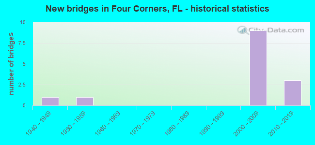
- New bridges - historical statistics
- 11940-1949
- 11950-1959
- 92000-2009
- 32010-2019

- Reconstructed bridges - Historical Statistics
- 11960-1969
- 01970-1979
- 01980-1989
- 01990-1999
- 12000-2009


- Bridge Condition - Deck
- 40.0%Very good
- 40.0%Good
- 20.0%Satisfactory

- Bridge Condition - Superstructure
- 80.0%Very good
- 20.0%Good

- Bridge Condition - Substructure
- 80.0%Very good
- 20.0%Good

- Bridge Condition - Channel
- 33.3%Good
- 33.3%Satisfactory
- 33.3%Fair

- Bridge Condition - Culverts
- 75.0%Good
- 25.0%Fair
Find on map >> Show street view
Structure Number: 110015, Location: 5.1 Mi. N of Polk Co Line (Lat: 28.415422, Lng: -81.703458), Route carried "on" structure: US 25, Year Built: 1947, Year Reconstructed: 1973, Status: Open, Structure Length: 0.64m (2.10ft), Average Daily Traffic: 23,000 (year 2020), Truck Traffic: 13%, Average Future Daily Traffic: 39,905 (year 2042), Design Load: H 20, Features Intersected: Creek, Facility Carried by Structure: US-27
Minimum Vertical Clearance: 30+ m (98+ ft), Kilometerpoint: 8.172, Lanes on structure: 6, Base Highway Network: Yes, Owner: State Highway Agency, Approaching Roadway Width: 15.1m (49.5ft), Skew: 20 degrees, Material/Design: Concrete, Design/Construction: Culvert, Number Of Spans In Main Unit: 2, Length of Maximum Span: 3.0m (9.8ft)
Condition: Channel: Satisfactory, Culverts: Good, Operating Rating: 53.5 metric tons, Method Used To Determine Operating Rating: Load and Resistance Factor (LRFR), Inventory Rating: 41.5 metric tons, Method Used To Determine Inventory Rating: Load and Resistance Factor (LRFR), Structural Evaluation: Better than present minimum criteria, Waterway Adequacy: Equal to present desirable criteria, Approach Roadway Alignment: Equal to present desirable criteria, Length Of Structure Improvement: 4.58m (15.03ft), Designated Inspection Frequency: Every 24 months, Inspection Date: November 2021, Bridge Improvement Cost: $73,000, Total Project Cost: $95,000
Find on map >> Show street view
Structure Number: 160331, Location: 2.5 MI EAST OF US-27 (Lat: 28.254219, Lng: -81.620444), Route carried "on" structure: State highway 54, Year Built: 2004, Year Reconstructed: 2009, Status: Open, Structure Length: 10.23m (33.56ft), Average Daily Traffic: 8,850 (year 2020), Truck Traffic: 8%, Average Future Daily Traffic: 15,355 (year 2042), Design Load: HL 93, Features Intersected: I-4 (SR-400)
Minimum Vertical Clearance: 30+ m (98+ ft), Kilometerpoint: 3.787, Lanes on structure: 2, Lanes under structure: 6, Owner: State Highway Agency, Approaching Roadway Width: 11.1m (36.4ft), Skew: 1 degrees, Material/Design: Steel continuous, Design/Construction: Stringer/Multi-beam, Number Of Spans In Main Unit: 2, Length of Maximum Span: 51.1m (167.7ft), Curb or Sidewalk Widths: Left: 0.0m, Right: 1.8m (5.9ft), Curb-To-Curb Width: 11.1m (36.4ft), Out-to-Out Width: 14.4m (47.2ft)
Condition: Deck: Satisfactory, Superstructure: Very good, Substructure: Very good, Operating Rating: 45.1 metric tons, Method Used To Determine Operating Rating: Load and Resistance Factor (LRFR), Inventory Rating: 34.7 metric tons, Method Used To Determine Inventory Rating: Load and Resistance Factor (LRFR), Structural Evaluation: Equal to present desirable criteria, Deck Geometry: Equal to present minimum criteria, Underclear: Equal to present minimum criteria, Approach Roadway Alignment: Equal to present desirable criteria, Designated Inspection Frequency: Every 24 months, Inspection Date: August 2020, Deck Structure Type: Concrete Cast-file-Place
Find on map >> Show street view
Structure Number: 160332, Location: 2.5 MI EAST OF US-27 (Lat: 28.254111, Lng: -81.620583), Route carried "on" structure: State highway 54, Year Built: 2009, Status: Open, Structure Length: 10.23m (33.56ft), Average Daily Traffic: 8,850 (year 2020), Truck Traffic: 8%, Average Future Daily Traffic: 15,355 (year 2042), Design Load: HL 93, Features Intersected: I-4 (SR-400)
Minimum Vertical Clearance: 30+ m (98+ ft), Kilometerpoint: 3.779, Lanes on structure: 2, Lanes under structure: 6, Owner: State Highway Agency, Approaching Roadway Width: 9.4m (30.8ft), Skew: 1 degrees, Material/Design: Steel continuous, Design/Construction: Stringer/Multi-beam, Number Of Spans In Main Unit: 2, Length of Maximum Span: 51.1m (167.7ft), Curb or Sidewalk Widths: Left: 1.8m (5.9ft), Right: 0.0m, Curb-To-Curb Width: 9.4m (30.8ft), Out-to-Out Width: 12.4m (40.7ft)
Condition: Deck: Very good, Superstructure: Very good, Substructure: Very good, Operating Rating: 47.7 metric tons, Method Used To Determine Operating Rating: Load and Resistance Factor (LRFR), Inventory Rating: 36.9 metric tons, Method Used To Determine Inventory Rating: Load and Resistance Factor (LRFR), Structural Evaluation: Equal to present desirable criteria, Deck Geometry: Meets minimum limits, Underclear: Equal to present minimum criteria, Approach Roadway Alignment: Equal to present desirable criteria, Designated Inspection Frequency: Every 24 months, Inspection Date: August 2020, Deck Structure Type: Concrete Cast-file-Place
Find on map >> Show street view
Structure Number: 164533, Location: 2.2 MI EAST OF US-27 (Lat: 28.222139, Lng: -81.622917), Route carried "on" structure: County highway , Year Built: 2010, Status: Open, Structure Length: 3.51m (11.52ft), Average Daily Traffic: 500 (year 2021), Truck Traffic: 1%, Average Future Daily Traffic: 868 (year 2042), Design Load: HL 93, Features Intersected: HORSE CREEK, Facility Carried by Structure: ERNIE CALDWELL BLV
Minimum Vertical Clearance: 30.45m (99.90ft), Kilometerpoint: 0.000, Lanes on structure: 4, Owner: County Highway Agency, Approaching Roadway Width: 24.2m (79.4ft), Skew: 15 degrees, Material/Design: Prestressed concrete, Design/Construction: Stringer/Multi-beam, Number Of Spans In Main Unit: 3, Length of Maximum Span: 11.7m (38.4ft), Curb or Sidewalk Widths: Left: 1.5m (4.9ft), Right: 1.5m (4.9ft), Curb-To-Curb Width: 24.2m (79.4ft), Out-to-Out Width: 28.7m (94.2ft)
Condition: Deck: Good, Superstructure: Very good, Substructure: Very good, Channel: Good, Operating Rating: 55.5 metric tons, Method Used To Determine Operating Rating: Load and Resistance Factor (LRFR), Inventory Rating: 42.1 metric tons, Method Used To Determine Inventory Rating: Load and Resistance Factor (LRFR), Structural Evaluation: Equal to present desirable criteria, Deck Geometry: Superior to present desirable criteria, Waterway Adequacy: Equal to present desirable criteria, Approach Roadway Alignment: Equal to present desirable criteria, Designated Inspection Frequency: Every 24 months, Inspection Date: July 2021, Deck Structure Type: Concrete Cast-file-Place
Find on map >> Show street view
Structure Number: 164536, Location: 0.3 Mile E of Heller Brot (Lat: 28.222508, Lng: -81.643917), Route carried "on" structure: County highway , Year Built: 2015, Status: Open, Structure Length: 6.71m (22.01ft), Average Daily Traffic: 12,200 (year 2020), Truck Traffic: 2%, Average Future Daily Traffic: 21,167 (year 2042), Design Load: HL 93, Features Intersected: US-27 (SR-25), Facility Carried by Structure: Ernie Caldwell Blv
Minimum Vertical Clearance: 30+ m (98+ ft), Kilometerpoint: 0.000, Lanes on structure: 4, Lanes under structure: 7, Owner: County Highway Agency, Approaching Roadway Width: 18.9m (62.0ft), Skew: 20 degrees, Material/Design: Steel, Design/Construction: Stringer/Multi-beam, Number Of Spans In Main Unit: 1, Length of Maximum Span: 67.1m (220.1ft), Curb or Sidewalk Widths: Left: 1.6m (5.2ft), Right: 1.6m (5.2ft), Curb-To-Curb Width: 18.9m (62.0ft), Out-to-Out Width: 28.7m (94.2ft)
Condition: Deck: Very good, Superstructure: Very good, Substructure: Very good, Operating Rating: 53.7 metric tons, Method Used To Determine Operating Rating: Load and Resistance Factor (LRFR), Inventory Rating: 41.5 metric tons, Method Used To Determine Inventory Rating: Load and Resistance Factor (LRFR), Structural Evaluation: Equal to present desirable criteria, Deck Geometry: Equal to present minimum criteria, Underclear: Better than present minimum criteria, Approach Roadway Alignment: Equal to present desirable criteria, Designated Inspection Frequency: Every 24 months, Inspection Date: June 2021, Deck Structure Type: Concrete Cast-file-Place
Find on map >> Show street view
Structure Number: 924147, Location: 0.8 Mile North of CR-532 (Lat: 28.271200, Lng: -81.590644), Route carried "on" structure: County highway 545, Year Built: 1954, Status: Open, Structure Length: 1.75m (5.74ft), Average Daily Traffic: 17,900 (year 2020), Truck Traffic: 24%, Average Future Daily Traffic: 31,057 (year 2042), Design Load: HS 20, Features Intersected: Davenport Creek, Facility Carried by Structure: Old Lake Wilson Rd
Minimum Vertical Clearance: 30+ m (98+ ft), Kilometerpoint: 1.297, Lanes on structure: 2, Owner: County Highway Agency, Approaching Roadway Width: 6.4m (21.0ft), Material/Design: Steel, Design/Construction: Culvert, Number Of Spans In Main Unit: 4, Length of Maximum Span: 3.5m (11.5ft)
Condition: Channel: Fair, Culverts: Fair, Structural Evaluation: Somewhat better than minimum adequacy, Waterway Adequacy: Equal to present minimum criteria, Approach Roadway Alignment: Better than present minimum criteria, Designated Inspection Frequency: Every 24 months, Underwater Inspection Frequency: Every 24 months, Inspection Date: July 2020, Underwater Inspection Date: July 2020
Find on map >> Show street view
Structure Number: 924179, Location: 3.3mi. South of US-192 (Lat: 28.284753, Lng: -81.590444), Route carried "on" structure: County highway 545, Year Built: 2005, Status: Open, Structure Length: 26.82m (87.99ft), Average Daily Traffic: 3,500 (year 2020), Truck Traffic: 8%, Average Future Daily Traffic: 5,000 (year 2042), Design Load: HS 20, Features Intersected: I-4
Minimum Vertical Clearance: 30+ m (98+ ft), Kilometerpoint: 2.675, Lanes on structure: 2, Lanes under structure: 7, Owner: County Highway Agency, Approaching Roadway Width: 10.1m (33.1ft), Skew: 9 degrees, Material/Design: Steel continuous, Design/Construction: Stringer/Multi-beam, Number Of Spans In Main Unit: 4, Length of Maximum Span: 77.1m (253.0ft), Curb-To-Curb Width: 12.2m (40.0ft), Out-to-Out Width: 13.1m (43.0ft)
Condition: Deck: Good, Superstructure: Good, Substructure: Good, Operating Rating: 70.9 metric tons, Method Used To Determine Operating Rating: Load Factor (LF), Inventory Rating: 42.5 metric tons, Method Used To Determine Inventory Rating: Load Factor (LF), Structural Evaluation: Better than present minimum criteria, Deck Geometry: Equal to present minimum criteria, Underclear: Meets minimum limits, Approach Roadway Alignment: Equal to present desirable criteria, Designated Inspection Frequency: Every 24 months, Inspection Date: June 2020, Deck Structure Type: Concrete Cast-file-Place
Find on map >> Show street view
Structure Number: 925501, Location: 0.4 Mile South of I-4 (Lat: 28.278850, Lng: -81.590639), Route carried "on" structure: County highway 545, Year Built: 2005, Status: Open, Structure Length: 0.73m (2.40ft), Average Daily Traffic: 16,700 (year 2021), Truck Traffic: 13%, Average Future Daily Traffic: 28,975 (year 2042), Design Load: HS 20, Features Intersected: Golf Cart Crossing #2
Minimum Vertical Clearance: 30+ m (98+ ft), Kilometerpoint: 2.116, Lanes on structure: 2, Owner: County Highway Agency, Approaching Roadway Width: 10.5m (34.4ft), Material/Design: Concrete, Design/Construction: Culvert, Number Of Spans In Main Unit: 1, Length of Maximum Span: 7.3m (24.0ft)
Condition: Culverts: Good, Operating Rating: 56.2 metric tons, Method Used To Determine Operating Rating: Load Factor (LF), Inventory Rating: 33.7 metric tons, Method Used To Determine Inventory Rating: Load Factor (LF), Structural Evaluation: Better than present minimum criteria, Approach Roadway Alignment: Equal to present desirable criteria, Designated Inspection Frequency: Every 24 months, Inspection Date: August 2021
Find on map >> Show street view
Structure Number: 925502, Location: 1.4 Miles South of I-4 (Lat: 28.263989, Lng: -81.590664), Route carried "on" structure: County highway 545, Year Built: 2005, Status: Open, Structure Length: 0.73m (2.40ft), Average Daily Traffic: 16,700 (year 2021), Truck Traffic: 13%, Average Future Daily Traffic: 28,975 (year 2042), Design Load: HS 20, Features Intersected: Golf Cart Crossing #1
Minimum Vertical Clearance: 30+ m (98+ ft), Kilometerpoint: 0.470, Lanes on structure: 2, Owner: County Highway Agency, Approaching Roadway Width: 7.0m (23.0ft), Material/Design: Concrete, Design/Construction: Culvert, Number Of Spans In Main Unit: 1, Length of Maximum Span: 7.3m (24.0ft)
Condition: Culverts: Good, Operating Rating: 56.2 metric tons, Method Used To Determine Operating Rating: Load Factor (LF), Inventory Rating: 33.7 metric tons, Method Used To Determine Inventory Rating: Load Factor (LF), Structural Evaluation: Better than present minimum criteria, Approach Roadway Alignment: Equal to present desirable criteria, Designated Inspection Frequency: Every 24 months, Inspection Date: August 2021
Find on map >> Show street view
Structure Number: 160331, Location: 2.5 MI EAST OF US-27 (Lat: 28.254219, Lng: -81.620444), Route carried "under" structure: Interstate 4, Year Built: 2004, Structure Length: 0. m, Average Daily Traffic: 115,000 (year 2020), Truck Traffic: 17%, Features Intersected: I-4 (SR-400)
Minimum Vertical Clearance: 5.06m (16.60ft), Kilometerpoint: 50.723, Lanes on structure: 2, Lanes under structure: 6, Material/Design: Steel continuous, Design/Construction: Stringer/Multi-beam, Length of Maximum Span: 51.1m (167.7ft)
Find on map >> Show street view
Structure Number: 160332, Location: 2.5 MI EAST OF US-27 (Lat: 28.254111, Lng: -81.620583), Route carried "under" structure: Interstate 4, Year Built: 2009, Structure Length: 0. m, Average Daily Traffic: 115,000 (year 2020), Truck Traffic: 17%, Features Intersected: I-4 (SR-400)
Minimum Vertical Clearance: 5.06m (16.60ft), Kilometerpoint: 50.694, Lanes on structure: 2, Lanes under structure: 6, Material/Design: Steel continuous, Design/Construction: Stringer/Multi-beam, Length of Maximum Span: 51.1m (167.7ft)
Find on map >> Show street view
Structure Number: 164536, Location: 0.3 Mile E of Heller Brot (Lat: 28.222508, Lng: -81.643917), Route carried "under" structure: US 27, Year Built: 2015, Structure Length: 0. m, Average Daily Traffic: 57,876 (year 2020), Truck Traffic: 10%, Features Intersected: US-27 (SR-25), Facility Carried by Structure: Ernie Caldwell Blv
Minimum Vertical Clearance: 5.83m (19.13ft), Kilometerpoint: 37.309, Lanes on structure: 4, Lanes under structure: 7, Material/Design: Steel, Design/Construction: Stringer/Multi-beam, Length of Maximum Span: 67.1m (220.1ft)
Find on map >> Show street view
Structure Number: 924179, Location: 3.3mi. South of US-192 (Lat: 28.284753, Lng: -81.590444), Route carried "under" structure: Ramp Interstate 4, Year Built: 2005, Structure Length: 0. m, Average Daily Traffic: 3,000 (year 2020), Truck Traffic: 10%, Features Intersected: I-4
Minimum Vertical Clearance: 6.40m (21.00ft), Kilometerpoint: 3.619, Lanes on structure: 2, Lanes under structure: 1, Material/Design: Steel continuous, Design/Construction: Stringer/Multi-beam, Length of Maximum Span: 77.1m (253.0ft)
Find on map >> Show street view
Structure Number: 924179, Location: 3.3mi. South of US-192 (Lat: 28.284753, Lng: -81.590444), Route carried "under" structure: Interstate 4, Year Built: 2005, Structure Length: 0. m, Average Daily Traffic: 93,000 (year 2020), Truck Traffic: 13%, Features Intersected: I-4
Minimum Vertical Clearance: 6.40m (21.00ft), Kilometerpoint: 3.619, Lanes on structure: 2, Lanes under structure: 6, Material/Design: Steel continuous, Design/Construction: Stringer/Multi-beam, Length of Maximum Span: 77.1m (253.0ft)