Bridge Statistics for Fort Pierce North, Florida (FL)
Condition, Traffic, Stress, Structural Evaluation, Project Costs
- National Bridge Inventory (NBI) Statistics
- 11Number of bridges
- 184ft / 56.0mTotal length
- 82,486Total average daily traffic
- 13,350Total average daily truck traffic
- National Bridge Inventory (NBI) Registered Bridges for Fort Pierce North
- No street view available for this location
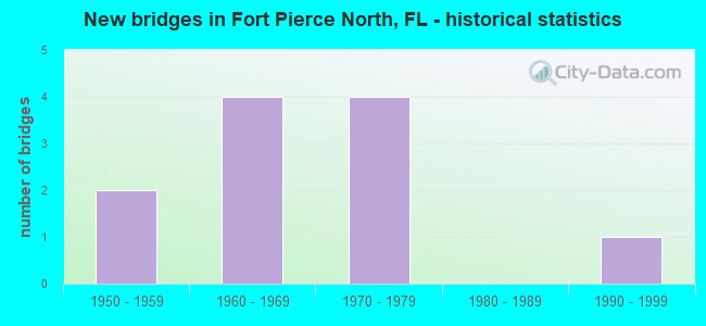
- New bridges - historical statistics
- 21950-1959
- 41960-1969
- 41970-1979
- 11990-1999


- Bridge Condition - Deck
- 66.7%Good
- 11.1%Satisfactory
- 22.2%Fair

- Bridge Condition - Superstructure
- 66.7%Good
- 11.1%Satisfactory
- 22.2%Fair

- Bridge Condition - Substructure
- 11.1%Very good
- 44.4%Good
- 44.4%Satisfactory

- Bridge Condition - Channel
- 66.7%Good
- 22.2%Satisfactory
- 11.1%Fair
Find on map >> Show street view
Structure Number: 940007, Location: 1.5mi. N of SR-68 (Lat: 27.469903, Lng: -80.399097), Route carried "on" structure: State highway 713, Year Built: 1963, Status: Open, Structure Length: 4.00m (13.12ft), Average Daily Traffic: 10,500 (year 2020), Truck Traffic: 10%, Average Future Daily Traffic: 18,218 (year 2042), Design Load: HS 20, Features Intersected: Belcher Canal (C-25), Facility Carried by Structure: Kings Highway
Minimum Vertical Clearance: 30+ m (98+ ft), Kilometerpoint: 6.301, Lanes on structure: 2, Owner: State Highway Agency, Approaching Roadway Width: 11.6m (38.1ft), Material/Design: Prestressed concrete, Design/Construction: Slab, Number Of Spans In Main Unit: 5, Length of Maximum Span: 8.0m (26.2ft), Curb-To-Curb Width: 8.6m (28.2ft), Out-to-Out Width: 8.6m (28.2ft)
Condition: Deck: Good, Superstructure: Good, Substructure: Good, Channel: Good, Operating Rating: 57.2 metric tons, Method Used To Determine Operating Rating: Load and Resistance Factor (LRFR), Inventory Rating: 48.2 metric tons, Method Used To Determine Inventory Rating: Load and Resistance Factor (LRFR), Structural Evaluation: Better than present minimum criteria, Deck Geometry: High priority of replacement, Waterway Adequacy: Better than present minimum criteria, Approach Roadway Alignment: Equal to present desirable criteria, Designated Inspection Frequency: Every 24 months, Underwater Inspection Frequency: Every 24 months, Inspection Date: August 2020, Underwater Inspection Date: August 2020, Deck Structure Type: Concrete Precast Panels, Wearing Surface/Protective System: Wearing Surface: Bituminous
Find on map >> Show street view
Structure Number: 940037, Location: 0.5MI S of CR-608 (Lat: 27.476831, Lng: -80.382650), Route carried "on" structure: County highway 611, Year Built: 1953, Status: Posted for load-capacity, Structure Length: 3.22m (10.56ft), Average Daily Traffic: 2,000 (year 2021), Truck Traffic: 5%, Average Future Daily Traffic: 3,470 (year 2042), Design Load: HS 20, Features Intersected: TAYLOR CREEK CANAL-1
Minimum Vertical Clearance: 30+ m (98+ ft), Kilometerpoint: 7.685, Lanes on structure: 2, Owner: County Highway Agency, Approaching Roadway Width: 6.2m (20.3ft), Material/Design: Concrete, Design/Construction: Slab, Number Of Spans In Main Unit: 7, Length of Maximum Span: 4.6m (15.1ft), Curb or Sidewalk Widths: Left: 0.1m (0.3ft), Right: 0.1m (0.3ft), Curb-To-Curb Width: 7.4m (24.3ft), Out-to-Out Width: 7.8m (25.6ft)
Condition: Deck: Satisfactory, Superstructure: Satisfactory, Substructure: Satisfactory, Channel: Fair, Operating Rating: 38.1 metric tons, Method Used To Determine Operating Rating: Load Factor (LF), Inventory Rating: 22.9 metric tons, Method Used To Determine Inventory Rating: Load Factor (LF), Structural Evaluation: Equal to present minimum criteria, Deck Geometry: Meets minimum limits, Waterway Adequacy: Better than present minimum criteria, Approach Roadway Alignment: Equal to present desirable criteria, Designated Inspection Frequency: Every 24 months, Underwater Inspection Frequency: Every 24 months, Inspection Date: January 2021, Underwater Inspection Date: January 2021, Deck Structure Type: Concrete Precast Panels
Find on map >> Show street view
Structure Number: 940041, Location: ADJ TO CR-607A ANGLE RD (Lat: 27.469853, Lng: -80.390842), Route carried "on" structure: County highway , Year Built: 1962, Status: Posted for load, Structure Length: 4.57m (14.99ft), Average Daily Traffic: 300 (year 2022), Truck Traffic: 5%, Average Future Daily Traffic: 500 (year 2042), Design Load: H 10, Features Intersected: BELCHER CANAL C-25, Facility Carried by Structure: TAYLOR DAIRY ROAD
Minimum Vertical Clearance: 30+ m (98+ ft), Kilometerpoint: 0.000, Lanes on structure: 2, Owner: County Highway Agency, Approaching Roadway Width: 6.0m (19.7ft), Material/Design: Prestressed concrete, Design/Construction: Slab, Number Of Spans In Main Unit: 5, Length of Maximum Span: 9.1m (29.9ft), Curb-To-Curb Width: 7.3m (24.0ft), Out-to-Out Width: 7.6m (24.9ft)
Condition: Deck: Fair, Superstructure: Fair, Substructure: Satisfactory, Channel: Good, Operating Rating: 38.5 metric tons, Method Used To Determine Operating Rating: Load Factor (LF), Inventory Rating: 23.0 metric tons, Method Used To Determine Inventory Rating: Load Factor (LF), Structural Evaluation: Somewhat better than minimum adequacy, Deck Geometry: Somewhat better than minimum adequacy, Waterway Adequacy: Better than present minimum criteria, Approach Roadway Alignment: Equal to present desirable criteria, Bridge Posting: Required (Relationship of Operating Rating to Maximum Legal Load: 10.0 - 19.9% below), Designated Inspection Frequency: Every 24 months, Underwater Inspection Frequency: Every 24 months, Other Special Inspection Frequency: Every 12 months, Inspection Date: January 2021, Underwater Inspection Date: January 2021, Other Special Inspection Date: January 2022, Deck Structure Type: Concrete Precast Panels, Wearing Surface/Protective System: Wearing Surface: Bituminous
Find on map >> Show street view
Structure Number: 940043, Location: 0.6MI N OF ANGLE ROAD (Lat: 27.476925, Lng: -80.390681), Route carried "on" structure: Business City street , Year Built: 1962, Status: Posted for load, Structure Length: 3.17m (10.40ft), Average Daily Traffic: 300 (year 2022), Truck Traffic: 5%, Average Future Daily Traffic: 700 (year 2042), Design Load: H 10, Features Intersected: CANAL-1, Facility Carried by Structure: TAYLOR DAIRY ROAD
Minimum Vertical Clearance: 30+ m (98+ ft), Kilometerpoint: 0.000, Lanes on structure: 2, Owner: County Highway Agency, Approaching Roadway Width: 5.5m (18.0ft), Material/Design: Concrete, Design/Construction: Slab, Number Of Spans In Main Unit: 4, Length of Maximum Span: 7.9m (25.9ft), Curb-To-Curb Width: 7.3m (24.0ft), Out-to-Out Width: 7.6m (24.9ft)
Condition: Deck: Good, Superstructure: Good, Substructure: Satisfactory, Channel: Satisfactory, Operating Rating: 32.4 metric tons, Method Used To Determine Operating Rating: Load Factor (LF), Inventory Rating: 19.4 metric tons, Method Used To Determine Inventory Rating: Load Factor (LF), Structural Evaluation: Somewhat better than minimum adequacy, Deck Geometry: Somewhat better than minimum adequacy, Waterway Adequacy: Better than present minimum criteria, Approach Roadway Alignment: Equal to present desirable criteria, Bridge Posting: Required (Relationship of Operating Rating to Maximum Legal Load: 20.0 - 29.9% below), Designated Inspection Frequency: Every 24 months, Underwater Inspection Frequency: Every 24 months, Other Special Inspection Frequency: Every 12 months, Inspection Date: January 2021, Underwater Inspection Date: January 2021, Other Special Inspection Date: January 2022, Deck Structure Type: Concrete Cast-file-Place
Find on map >> Show street view
Structure Number: 940068, Location: 100FT N ANGLE RD CR-607A (Lat: 27.469572, Lng: -80.378492), Route carried "on" structure: County highway , Year Built: 1959, Status: Posted for load, Structure Length: 3.96m (12.99ft), Average Daily Traffic: 4,500 (year 2022), Truck Traffic: 10%, Average Future Daily Traffic: 7,140 (year 2042), Design Load: H 10, Features Intersected: BELCHER CANAL C-25, Facility Carried by Structure: 53RD STREET
Minimum Vertical Clearance: 30+ m (98+ ft), Kilometerpoint: 0.045, Lanes on structure: 2, Owner: County Highway Agency, Approaching Roadway Width: 6.4m (21.0ft), Material/Design: Concrete, Design/Construction: Slab, Number Of Spans In Main Unit: 5, Length of Maximum Span: 7.9m (25.9ft), Curb-To-Curb Width: 7.3m (24.0ft), Out-to-Out Width: 7.6m (24.9ft)
Condition: Deck: Good, Superstructure: Good, Substructure: Satisfactory, Channel: Good, Operating Rating: 31.9 metric tons, Method Used To Determine Operating Rating: Load Factor (LF), Inventory Rating: 19.1 metric tons, Method Used To Determine Inventory Rating: Load Factor (LF), Structural Evaluation: Somewhat better than minimum adequacy, Deck Geometry: High priority of replacement, Waterway Adequacy: Better than present minimum criteria, Approach Roadway Alignment: Equal to present desirable criteria, Bridge Posting: Required (Relationship of Operating Rating to Maximum Legal Load: 20.0 - 29.9% below), Designated Inspection Frequency: Every 24 months, Underwater Inspection Frequency: Every 24 months, Other Special Inspection Frequency: Every 12 months, Inspection Date: January 2021, Underwater Inspection Date: January 2021, Other Special Inspection Date: January 2022, Deck Structure Type: Concrete Cast-file-Place
Find on map >> Show street view
Structure Number: 940071, Location: 100FT N OF ANGLE ROAD (Lat: 27.470108, Lng: -80.419931), Route carried "on" structure: County highway 603, Year Built: 1962, Status: Open, Structure Length: 4.57m (14.99ft), Average Daily Traffic: 1,086 (year 2021), Truck Traffic: 5%, Average Future Daily Traffic: 1,884 (year 2042), Design Load: H 15, Features Intersected: BELCHER CANAL C-25
Minimum Vertical Clearance: 30+ m (98+ ft), Kilometerpoint: 0.051, Lanes on structure: 2, Owner: County Highway Agency, Approaching Roadway Width: 7.3m (24.0ft), Material/Design: Prestressed concrete, Design/Construction: Slab, Number Of Spans In Main Unit: 5, Length of Maximum Span: 9.1m (29.9ft), Curb or Sidewalk Widths: Left: 0.2m (0.7ft), Right: 0.2m (0.7ft), Curb-To-Curb Width: 7.3m (24.0ft), Out-to-Out Width: 7.8m (25.6ft)
Condition: Deck: Fair, Superstructure: Fair, Substructure: Good, Channel: Satisfactory, Operating Rating: 47.5 metric tons, Method Used To Determine Operating Rating: Allowable Stress (AS), Inventory Rating: 28.9 metric tons, Method Used To Determine Inventory Rating: Allowable Stress (AS), Structural Evaluation: Somewhat better than minimum adequacy, Deck Geometry: Meets minimum limits, Waterway Adequacy: Better than present minimum criteria, Approach Roadway Alignment: Equal to present desirable criteria, Designated Inspection Frequency: Every 24 months, Underwater Inspection Frequency: Every 24 months, Inspection Date: January 2021, Underwater Inspection Date: January 2021, Deck Structure Type: Concrete Precast Panels, Wearing Surface/Protective System: Wearing Surface: Bituminous
Find on map >> Show street view
Structure Number: 940092, Location: 2.5 mi. N of SR 70 (Lat: 27.470081, Lng: -80.425756), Route carried "on" structure: Interstate 95, Year Built: 1977, Year Reconstructed: 2013, Status: Open, Structure Length: 15.14m (49.67ft), Average Daily Traffic: 24,250 (year 2020), Truck Traffic: 21%, Average Future Daily Traffic: 42,074 (year 2042), Design Load: HL 93, Features Intersected: Angle Rd - Belcher Canal
Minimum Vertical Clearance: 30+ m (98+ ft), Kilometerpoint: 32.480, Lanes on structure: 4, Lanes under structure: 2, Base Highway Network: Yes, Owner: State Highway Agency, Approaching Roadway Width: 21.6m (70.9ft), Skew: 4 degrees, Material/Design: Prestressed concrete, Design/Construction: Stringer/Multi-beam, Number Of Spans In Main Unit: 6, Length of Maximum Span: 31.3m (102.7ft), Curb-To-Curb Width: 21.6m (70.9ft), Out-to-Out Width: 22.5m (73.8ft)
Condition: Deck: Good, Superstructure: Good, Substructure: Good, Channel: Good, Operating Rating: 41.2 metric tons, Method Used To Determine Operating Rating: Load and Resistance Factor (LRFR), Inventory Rating: 37.2 metric tons, Method Used To Determine Inventory Rating: Load and Resistance Factor (LRFR), Structural Evaluation: Better than present minimum criteria, Deck Geometry: Better than present minimum criteria, Underclear: Better than present minimum criteria, Waterway Adequacy: Better than present minimum criteria, Approach Roadway Alignment: Equal to present desirable criteria, Designated Inspection Frequency: Every 24 months, Underwater Inspection Frequency: Every 24 months, Inspection Date: August 2020, Underwater Inspection Date: August 2020, Deck Structure Type: Concrete Cast-file-Place
Find on map >> Show street view
Structure Number: 940093, Location: 2.5 mi. N of SR 70 (Lat: 27.470078, Lng: -80.427383), Route carried "on" structure: Interstate 95, Year Built: 1977, Year Reconstructed: 2013, Status: Open, Structure Length: 14.91m (48.92ft), Average Daily Traffic: 24,250 (year 2020), Truck Traffic: 21%, Average Future Daily Traffic: 42,074 (year 2042), Design Load: HL 93, Features Intersected: Angle Rd.- Belcher Canal
Minimum Vertical Clearance: 30+ m (98+ ft), Kilometerpoint: 32.580, Lanes on structure: 4, Lanes under structure: 2, Base Highway Network: Yes, Owner: State Highway Agency, Approaching Roadway Width: 21.6m (70.9ft), Skew: 4 degrees, Material/Design: Prestressed concrete, Design/Construction: Stringer/Multi-beam, Number Of Spans In Main Unit: 6, Length of Maximum Span: 29.8m (97.8ft), Curb-To-Curb Width: 21.6m (70.9ft), Out-to-Out Width: 22.5m (73.8ft)
Condition: Deck: Good, Superstructure: Good, Substructure: Good, Channel: Good, Operating Rating: 44.7 metric tons, Method Used To Determine Operating Rating: Load and Resistance Factor (LRFR), Inventory Rating: 36.9 metric tons, Method Used To Determine Inventory Rating: Load and Resistance Factor (LRFR), Structural Evaluation: Better than present minimum criteria, Deck Geometry: Better than present minimum criteria, Underclear: Better than present minimum criteria, Waterway Adequacy: Better than present minimum criteria, Approach Roadway Alignment: Equal to present desirable criteria, Designated Inspection Frequency: Every 24 months, Underwater Inspection Frequency: Every 24 months, Inspection Date: August 2020, Underwater Inspection Date: August 2020, Deck Structure Type: Concrete Cast-file-Place
Find on map >> Show street view
Structure Number: 940143, Location: .5mi So. of St Lucie Blvd (Lat: 27.477006, Lng: -80.398872), Route carried "on" structure: State highway 713, Year Built: 1993, Status: Open, Structure Length: 2.44m (8.01ft), Average Daily Traffic: 10,500 (year 2020), Truck Traffic: 10%, Average Future Daily Traffic: 18,218 (year 2042), Design Load: HS 20+Mod, Features Intersected: F.P.F.W.C.D. Canal No. 1
Minimum Vertical Clearance: 30+ m (98+ ft), Kilometerpoint: 7.105, Lanes on structure: 2, Owner: State Highway Agency, Approaching Roadway Width: 7.7m (25.3ft), Material/Design: Concrete continuous, Design/Construction: Slab, Number Of Spans In Main Unit: 3, Length of Maximum Span: 9.1m (29.9ft), Curb-To-Curb Width: 12.4m (40.7ft), Out-to-Out Width: 13.1m (43.0ft)
Condition: Deck: Good, Superstructure: Good, Substructure: Very good, Channel: Good, Operating Rating: 50.4 metric tons, Method Used To Determine Operating Rating: Load Factor (LF), Inventory Rating: 30.2 metric tons, Method Used To Determine Inventory Rating: Load Factor (LF), Structural Evaluation: Better than present minimum criteria, Deck Geometry: Somewhat better than minimum adequacy, Waterway Adequacy: Superior to present desirable criteria, Approach Roadway Alignment: Equal to present desirable criteria, Designated Inspection Frequency: Every 24 months, Underwater Inspection Frequency: Every 24 months, Inspection Date: August 2020, Underwater Inspection Date: August 2020, Deck Structure Type: Concrete Cast-file-Place
Find on map >> Show street view
Structure Number: 940092, Location: 2.5 mi. N of SR 70 (Lat: 27.470081, Lng: -80.425756), Route carried "under" structure: County highway , Year Built: 1977, Structure Length: 0. m, Average Daily Traffic: 2,400 (year 2020), Truck Traffic: 9%, Features Intersected: Angle Rd - Belcher Canal, Facility Carried by Structure: NB I-95 (SR-9)
Minimum Vertical Clearance: 4.82m (15.81ft), Kilometerpoint: 1.819, Lanes on structure: 4, Lanes under structure: 2, Material/Design: Prestressed concrete, Design/Construction: Stringer/Multi-beam, Length of Maximum Span: 31.3m (102.7ft)
Find on map >> Show street view
Structure Number: 940093, Location: 2.5 mi. N of SR 70 (Lat: 27.470078, Lng: -80.427383), Route carried "under" structure: County highway , Year Built: 1977, Structure Length: 0. m, Average Daily Traffic: 2,400 (year 2020), Truck Traffic: 9%, Features Intersected: Angle Rd.- Belcher Canal, Facility Carried by Structure: SB I-95 (SR-9)
Minimum Vertical Clearance: 4.82m (15.81ft), Kilometerpoint: 1.637, Lanes on structure: 4, Lanes under structure: 2, Material/Design: Prestressed concrete, Design/Construction: Stringer/Multi-beam, Length of Maximum Span: 29.8m (97.8ft)