Bridge Statistics for Fort Lupton, Colorado (CO)
Condition, Traffic, Stress, Structural Evaluation, Project Costs
- National Bridge Inventory (NBI) Statistics
- 24Number of bridges
- 243ft / 74.0mTotal length
- $168,000Total costs
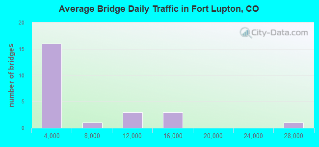
- 112,555Total average daily traffic
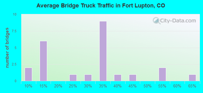
- 15,369Total average daily truck traffic
- National Bridge Inventory (NBI) Registered Bridges for Fort Lupton
- No street view available for this location
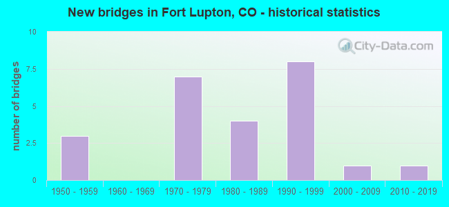
- New bridges - historical statistics
- 31950-1959
- 71970-1979
- 41980-1989
- 81990-1999
- 12000-2009
- 12010-2019
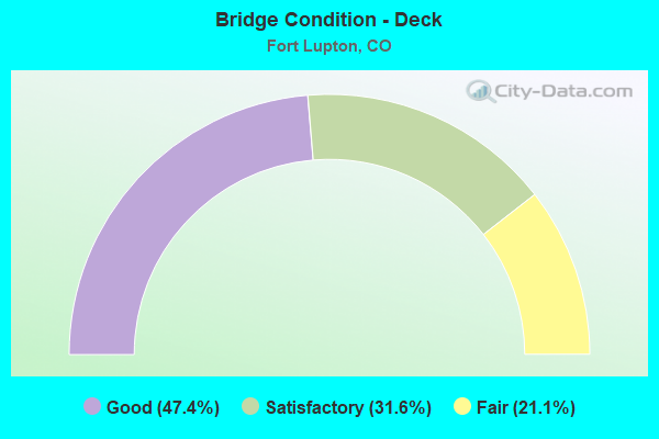
- Bridge Condition - Deck
- 47.4%Good
- 31.6%Satisfactory
- 21.1%Fair
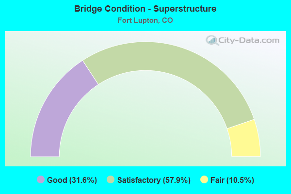
- Bridge Condition - Superstructure
- 31.6%Good
- 57.9%Satisfactory
- 10.5%Fair
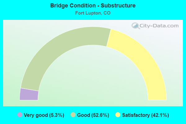
- Bridge Condition - Substructure
- 5.3%Very good
- 52.6%Good
- 42.1%Satisfactory
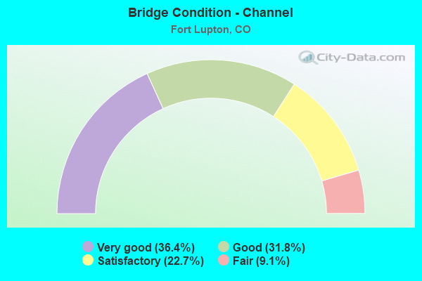
- Bridge Condition - Channel
- 36.4%Very good
- 31.8%Good
- 22.7%Satisfactory
- 9.1%Fair
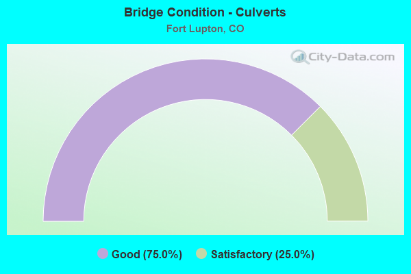
- Bridge Condition - Culverts
- 75.0%Good
- 25.0%Satisfactory
Find on map >> Show street view
Structure Number: D-17-BH, Location: .5 MI W OF FT LUPTON (Lat: 40.079903, Lng: -104.834150), Route carried "on" structure: State highway 52A, Year Built: 1957, Status: Open, Structure Length: 0.64m (2.10ft), Average Daily Traffic: 13,000 (year 2020), Truck Traffic: 10%, Average Future Daily Traffic: 18,330 (year 2040), Design Load: HS 20, Features Intersected: S PLATTE RIVER OVRFLW, Facility Carried by Structure: SH 52 ML
Minimum Vertical Clearance: 30+ m (98+ ft), Kilometerpoint: 30.911, Lanes on structure: 2, Base Highway Network: Yes, Owner: State Highway Agency, Approaching Roadway Width: 11.6m (38.1ft), Material/Design: Concrete, Design/Construction: Culvert, Number Of Spans In Main Unit: 2, Length of Maximum Span: 3.0m (9.8ft), Out-to-Out Width: 15.2m (49.9ft)
Condition: Channel: Satisfactory, Culverts: Satisfactory, Operating Rating: 36.3 metric tons, Method Used To Determine Operating Rating: Field evaluation and documented engineering judgment, Inventory Rating: 32.7 metric tons, Method Used To Determine Inventory Rating: Field evaluation and documented engineering judgment, Structural Evaluation: Equal to present minimum criteria, Waterway Adequacy: Equal to present desirable criteria, Approach Roadway Alignment: Equal to present desirable criteria, Designated Inspection Frequency: Every 24 months, Inspection Date: December 2021
Find on map >> Show street view
Structure Number: D-17-DE, Location: IN FORT LUPTON (Lat: 40.079911, Lng: -104.819536), Route carried "on" structure: US 85C, Year Built: 1974, Status: Open, Structure Length: 4.50m (14.76ft), Average Daily Traffic: 24,000 (year 2020), Truck Traffic: 10%, Average Future Daily Traffic: 31,200 (year 2040), Design Load: HS 20, Features Intersected: SH 52 ML, Facility Carried by Structure: US 85 ML
Minimum Vertical Clearance: 30+ m (98+ ft), Kilometerpoint: 23.794, Lanes on structure: 4, Lanes under structure: 4, Base Highway Network: Yes, Owner: State Highway Agency, Approaching Roadway Width: 25.0m (82.0ft), Skew: 20 degrees, Material/Design: Prestressed concrete, Design/Construction: Box Beam or Girders - Multiple, Number Of Spans In Main Unit: 1, Length of Maximum Span: 44.2m (145.0ft), Curb-To-Curb Width: 25.7m (84.3ft), Out-to-Out Width: 27.0m (88.6ft)
Condition: Deck: Good, Superstructure: Good, Substructure: Good, Operating Rating: 51.3 metric tons, Method Used To Determine Operating Rating: Load Factor (LF), Inventory Rating: 30.8 metric tons, Method Used To Determine Inventory Rating: Load Factor (LF), Structural Evaluation: Better than present minimum criteria, Deck Geometry: Superior to present desirable criteria, Underclear: Better than present minimum criteria, Approach Roadway Alignment: Equal to present desirable criteria, Designated Inspection Frequency: Every 24 months, Inspection Date: August 2021, Deck Structure Type: Concrete Cast-file-Place, Wearing Surface/Protective System: Wearing Surface: Bituminous, Membrane: Preformed Fabric
Find on map >> Show street view
Structure Number: D-17-F, Location: 1.8 MI E OF JCT US 85 BYP (Lat: 40.080200, Lng: -104.786400), Route carried "on" structure: State highway 52A, Year Built: 1971, Status: Open, Structure Length: 0.67m (2.20ft), Average Daily Traffic: 11,000 (year 2020), Truck Traffic: 6%, Average Future Daily Traffic: 18,590 (year 2040), Design Load: HS 20+Mod, Features Intersected: FULTON DITCH, Facility Carried by Structure: SH 52 ML
Minimum Vertical Clearance: 30+ m (98+ ft), Kilometerpoint: 34.987, Lanes on structure: 2, Base Highway Network: Yes, Owner: State Highway Agency, Approaching Roadway Width: 8.5m (27.9ft), Skew: 5 degrees, Material/Design: Concrete, Design/Construction: Culvert, Number Of Spans In Main Unit: 1, Length of Maximum Span: 6.7m (22.0ft), Out-to-Out Width: 14.0m (45.9ft)
Condition: Channel: Very good, Culverts: Good, Operating Rating: 74.4 metric tons, Method Used To Determine Operating Rating: Load Factor (LF), Inventory Rating: 44.5 metric tons, Method Used To Determine Inventory Rating: Load Factor (LF), Structural Evaluation: Better than present minimum criteria, Waterway Adequacy: Equal to present desirable criteria, Approach Roadway Alignment: Equal to present desirable criteria, Designated Inspection Frequency: Every 24 months, Inspection Date: December 2021
Find on map >> Show street view
Structure Number: D-17-H, Location: 7.7 MI E OF JCT I25 (Lat: 40.079936, Lng: -104.840161), Route carried "on" structure: State highway 52A, Year Built: 1959, Status: Open, Structure Length: 0.74m (2.43ft), Average Daily Traffic: 13,000 (year 2020), Truck Traffic: 10%, Average Future Daily Traffic: 18,330 (year 2040), Design Load: HS 20, Features Intersected: CANAL, Facility Carried by Structure: SH 52 ML
Minimum Vertical Clearance: 30+ m (98+ ft), Kilometerpoint: 30.397, Lanes on structure: 2, Base Highway Network: Yes, Owner: State Highway Agency, Approaching Roadway Width: 12.2m (40.0ft), Skew: 3 degrees, Material/Design: Concrete, Design/Construction: Culvert, Number Of Spans In Main Unit: 1, Length of Maximum Span: 7.4m (24.3ft), Out-to-Out Width: 14.0m (45.9ft)
Condition: Channel: Good, Culverts: Good, Operating Rating: 36.3 metric tons, Method Used To Determine Operating Rating: Field evaluation and documented engineering judgment, Inventory Rating: 32.7 metric tons, Method Used To Determine Inventory Rating: Field evaluation and documented engineering judgment, Structural Evaluation: Better than present minimum criteria, Waterway Adequacy: Equal to present desirable criteria, Approach Roadway Alignment: Equal to present desirable criteria, Designated Inspection Frequency: Every 24 months, Inspection Date: December 2021
Find on map >> Show street view
Structure Number: D-17-I, Location: W OF JCT 85 @ FT LUPTON (Lat: 40.080039, Lng: -104.822086), Route carried "on" structure: State highway 52A, Year Built: 1957, Status: Open, Structure Length: 9.85m (32.32ft), Average Daily Traffic: 13,000 (year 2020), Truck Traffic: 10%, Average Future Daily Traffic: 18,330 (year 2040), Design Load: HS 20, Features Intersected: SOUTH PLATTE RIVER, Facility Carried by Structure: SH 52 ML
Minimum Vertical Clearance: 30+ m (98+ ft), Kilometerpoint: 31.941, Lanes on structure: 2, Base Highway Network: Yes, Owner: State Highway Agency, Approaching Roadway Width: 12.2m (40.0ft), Material/Design: Concrete, Design/Construction: Stringer/Multi-beam, Number Of Spans In Main Unit: 9, Length of Maximum Span: 10.7m (35.1ft), Curb or Sidewalk Widths: Left: 0.5m (1.6ft), Right: 0.5m (1.6ft), Curb-To-Curb Width: 9.1m (29.9ft), Out-to-Out Width: 10.4m (34.1ft)
Condition: Deck: Fair, Superstructure: Satisfactory, Substructure: Good, Channel: Fair, Operating Rating: 63.1 metric tons, Method Used To Determine Operating Rating: Load Factor (LF), Inventory Rating: 37.7 metric tons, Method Used To Determine Inventory Rating: Load Factor (LF), Structural Evaluation: Equal to present minimum criteria, Deck Geometry: Meets minimum limits, Waterway Adequacy: Equal to present desirable criteria, Approach Roadway Alignment: Equal to present desirable criteria, Designated Inspection Frequency: Every 24 months, Inspection Date: November 2021, Deck Structure Type: Concrete Cast-file-Place, Wearing Surface/Protective System: Wearing Surface: Bituminous, Membrane: Built-up
Find on map >> Show street view
Structure Number: D-18-BM, Location: 4.9 MI E OF JCT US 85 (Lat: 40.080278, Lng: -104.726686), Route carried "on" structure: State highway 52A, Year Built: 1971, Status: Open, Structure Length: 10.18m (33.40ft), Average Daily Traffic: 11,000 (year 2020), Truck Traffic: 6%, Average Future Daily Traffic: 18,590 (year 2040), Design Load: HS 20+Mod, Features Intersected: SPEER CANAL, Facility Carried by Structure: SH 52 ML
Minimum Vertical Clearance: 30+ m (98+ ft), Kilometerpoint: 40.077, Lanes on structure: 2, Base Highway Network: Yes, Owner: State Highway Agency, Approaching Roadway Width: 8.5m (27.9ft), Skew: 3 degrees, Material/Design: Steel, Design/Construction: Stringer/Multi-beam, Number Of Spans In Main Unit: 1, Length of Maximum Span: 9.8m (32.2ft), Curb-To-Curb Width: 13.4m (44.0ft), Out-to-Out Width: 14.1m (46.3ft)
Condition: Deck: Good, Superstructure: Good, Substructure: Very good, Channel: Very good, Operating Rating: 52.3 metric tons, Method Used To Determine Operating Rating: Load Factor (LF), Inventory Rating: 31.3 metric tons, Method Used To Determine Inventory Rating: Load Factor (LF), Structural Evaluation: Better than present minimum criteria, Deck Geometry: Equal to present minimum criteria, Waterway Adequacy: Superior to present desirable criteria, Approach Roadway Alignment: Equal to present desirable criteria, Designated Inspection Frequency: Every 24 months, Inspection Date: December 2021, Deck Structure Type: Concrete Cast-file-Place, Wearing Surface/Protective System: Wearing Surface: Bituminous
Find on map >> Show street view
Structure Number: FTL14TH-FULTONA, Location: 0.3 Mi W of US Hwy 85 (Lat: 40.094722, Lng: -104.818889), Route carried "on" structure: City street , Year Built: 1994, Status: Open, Structure Length: 1.08m (3.54ft), Average Daily Traffic: 1,205 (year 2020), Truck Traffic: 32%, Average Future Daily Traffic: 1,711 (year 2040), Design Load: HS 20, Features Intersected: Platteville Ditch, Facility Carried by Structure: 14th Street
Minimum Vertical Clearance: 30+ m (98+ ft), Kilometerpoint: 0.060, Lanes on structure: 2, Owner: City or Municipal Highway Agency, Approaching Roadway Width: 7.6m (24.9ft), Skew: 1 degrees, Material/Design: Prestressed concrete, Design/Construction: Tee Beam, Number Of Spans In Main Unit: 1, Length of Maximum Span: 9.7m (31.8ft), Curb-To-Curb Width: 10.9m (35.8ft), Out-to-Out Width: 11.7m (38.4ft)
Condition: Deck: Good, Superstructure: Satisfactory, Substructure: Good, Channel: Satisfactory, Operating Rating: 51.0 metric tons, Method Used To Determine Operating Rating: Load Factor (LF), Inventory Rating: 31.7 metric tons, Method Used To Determine Inventory Rating: Load Factor (LF), Structural Evaluation: Equal to present minimum criteria, Deck Geometry: Equal to present minimum criteria, Waterway Adequacy: Equal to present desirable criteria, Approach Roadway Alignment: Equal to present desirable criteria, Designated Inspection Frequency: Every 24 months, Inspection Date: March 2022, Deck Structure Type: Concrete Cast-file-Place, Wearing Surface/Protective System: Wearing Surface: Bituminous, Membrane: Built-up, Deck Protection: Epoxy Coated Reinforcing
Find on map >> Show street view
Structure Number: WEL006.0-023.1B, Location: 0.8 Mi E of Co Rd 23 (Lat: 40.029417, Lng: -104.831219), Route carried "on" structure: County highway , Year Built: 1989, Status: Open, Structure Length: 0.88m (2.89ft), Average Daily Traffic: 1,774 (year 2020), Truck Traffic: 30%, Average Future Daily Traffic: 2,519 (year 2040), Design Load: HS 20, Features Intersected: Lupton Bottom Ditch, Facility Carried by Structure: County Road 6
Minimum Vertical Clearance: 30+ m (98+ ft), Kilometerpoint: 11.114, Lanes on structure: 2, Owner: County Highway Agency, Approaching Roadway Width: 7.9m (25.9ft), Material/Design: Concrete, Design/Construction: Culvert, Number Of Spans In Main Unit: 2, Length of Maximum Span: 4.3m (14.1ft), Curb-To-Curb Width: 12.4m (40.7ft), Out-to-Out Width: 13.0m (42.7ft)
Condition: Channel: Good, Culverts: Good, Operating Rating: 51.6 metric tons, Method Used To Determine Operating Rating: Load Factor (LF), Inventory Rating: 30.9 metric tons, Method Used To Determine Inventory Rating: Load Factor (LF), Structural Evaluation: Better than present minimum criteria, Deck Geometry: Better than present minimum criteria, Waterway Adequacy: Equal to present desirable criteria, Approach Roadway Alignment: Equal to present desirable criteria, Designated Inspection Frequency: Every 24 months, Inspection Date: March 2022, Deck Structure Type: Concrete Cast-file-Place, Wearing Surface/Protective System: Wearing Surface: Bituminous, Membrane: Preformed Fabric
Find on map >> Show street view
Structure Number: WEL006.0-025.0A, Location: 1.1 Mi E of Co Rd 23 (Lat: 40.029722, Lng: -104.826667), Route carried "on" structure: County highway , Year Built: 1970, Year Reconstructed: 2012, Status: Open, Structure Length: 8.98m (29.46ft), Average Daily Traffic: 1,774 (year 2020), Truck Traffic: 30%, Average Future Daily Traffic: 2,519 (year 2040), Design Load: HS 20, Features Intersected: South Platte River, Facility Carried by Structure: County Road 6
Minimum Vertical Clearance: 30+ m (98+ ft), Kilometerpoint: 11.499, Lanes on structure: 2, Owner: County Highway Agency, Approaching Roadway Width: 7.3m (24.0ft), Material/Design: Prestressed concrete, Design/Construction: Tee Beam, Number Of Spans In Main Unit: 6, Length of Maximum Span: 14.6m (47.9ft), Curb or Sidewalk Widths: Left: 0.6m (2.0ft), Right: 0.6m (2.0ft), Curb-To-Curb Width: 8.0m (26.2ft), Out-to-Out Width: 9.2m (30.2ft)
Condition: Deck: Good, Superstructure: Satisfactory, Substructure: Satisfactory, Channel: Satisfactory, Operating Rating: 32.7 metric tons, Method Used To Determine Operating Rating: Field evaluation and documented engineering judgment, Inventory Rating: 32.7 metric tons, Method Used To Determine Inventory Rating: Field evaluation and documented engineering judgment, Structural Evaluation: Equal to present minimum criteria, Deck Geometry: Meets minimum limits, Waterway Adequacy: Equal to present desirable criteria, Approach Roadway Alignment: Equal to present desirable criteria, Designated Inspection Frequency: Every 24 months, Inspection Date: June 2020, Deck Structure Type: Concrete Cast-file-Place, Wearing Surface/Protective System: Wearing Surface: Bituminous
Find on map >> Show street view
Structure Number: WEL008.0-021.0A, Location: 0.9 Mi E of Co Rd 21 (Lat: 40.043611, Lng: -104.849167), Route carried "on" structure: County highway , Year Built: 1983, Status: Open, Structure Length: 1.19m (3.90ft), Average Daily Traffic: 182 (year 2020), Truck Traffic: 52%, Average Future Daily Traffic: 258 (year 2040), Design Load: HS 20, Features Intersected: Big Dry Creek, Facility Carried by Structure: County Road 8
Minimum Vertical Clearance: 30+ m (98+ ft), Kilometerpoint: 3.175, Lanes on structure: 2, Owner: County Highway Agency, Approaching Roadway Width: 7.3m (24.0ft), Skew: 3 degrees, Material/Design: Steel, Design/Construction: Stringer/Multi-beam, Number Of Spans In Main Unit: 1, Length of Maximum Span: 11.1m (36.4ft), Curb-To-Curb Width: 9.4m (30.8ft), Out-to-Out Width: 9.9m (32.5ft)
Condition: Deck: Good, Superstructure: Satisfactory, Substructure: Satisfactory, Channel: Good, Operating Rating: 59.1 metric tons, Method Used To Determine Operating Rating: Load Factor (LF), Inventory Rating: 35.5 metric tons, Method Used To Determine Inventory Rating: Load Factor (LF), Structural Evaluation: Equal to present minimum criteria, Deck Geometry: Equal to present minimum criteria, Waterway Adequacy: Better than present minimum criteria, Approach Roadway Alignment: Equal to present desirable criteria, Designated Inspection Frequency: Every 24 months, Inspection Date: June 2020, Deck Structure Type: Corrugated Steel, Wearing Surface/Protective System: Wearing Surface: Gravel
Find on map >> Show street view
Structure Number: WEL008.0-023.0A, Location: 0.6 Mi N of Co Rd 23 (Lat: 40.043806, Lng: -104.834472), Route carried "on" structure: County highway , Year Built: 1970, Status: Open, Structure Length: 1.22m (4.00ft), Average Daily Traffic: 205 (year 2020), Truck Traffic: 37%, Average Future Daily Traffic: 291 (year 2040), Features Intersected: Lupton Bottom Ditch, Facility Carried by Structure: County Road 8
Minimum Vertical Clearance: 30+ m (98+ ft), Kilometerpoint: 0.412, Lanes on structure: 2, Owner: County Highway Agency, Approaching Roadway Width: 7.3m (24.0ft), Material/Design: Prestressed concrete, Design/Construction: Tee Beam, Number Of Spans In Main Unit: 1, Length of Maximum Span: 11.8m (38.7ft), Curb-To-Curb Width: 9.6m (31.5ft), Out-to-Out Width: 9.8m (32.2ft)
Condition: Deck: Satisfactory, Superstructure: Fair, Substructure: Satisfactory, Channel: Good, Operating Rating: 32.7 metric tons, Method Used To Determine Operating Rating: Field evaluation and documented engineering judgment, Inventory Rating: 32.7 metric tons, Method Used To Determine Inventory Rating: Field evaluation and documented engineering judgment, Structural Evaluation: Somewhat better than minimum adequacy, Deck Geometry: Equal to present minimum criteria, Waterway Adequacy: Equal to present desirable criteria, Approach Roadway Alignment: Equal to present desirable criteria, Designated Inspection Frequency: Every 24 months, Inspection Date: March 2022, Deck Structure Type: Concrete Cast-file-Place, Wearing Surface/Protective System: Wearing Surface: Gravel
Find on map >> Show street view
Structure Number: WEL008.0-029.0A, Location: 0.1 Mi E of Co Rd 29 (Lat: 40.044056, Lng: -104.789444), Route carried "on" structure: County highway , Year Built: 1992, Status: Open, Structure Length: 0.72m (2.36ft), Average Daily Traffic: 1,996 (year 2020), Truck Traffic: 30%, Average Future Daily Traffic: 2,834 (year 2040), Design Load: HS 20, Features Intersected: Fulton Ditch, Facility Carried by Structure: County Road 8
Minimum Vertical Clearance: 30+ m (98+ ft), Kilometerpoint: 0.002, Lanes on structure: 2, Owner: County Highway Agency, Approaching Roadway Width: 7.6m (24.9ft), Skew: 3 degrees, Material/Design: Steel, Design/Construction: Stringer/Multi-beam, Number Of Spans In Main Unit: 1, Length of Maximum Span: 6.0m (19.7ft), Curb-To-Curb Width: 9.5m (31.2ft), Out-to-Out Width: 9.6m (31.5ft)
Condition: Deck: Satisfactory, Superstructure: Fair, Substructure: Satisfactory, Channel: Very good, Operating Rating: 37.4 metric tons, Method Used To Determine Operating Rating: Load Factor (LF), Inventory Rating: 22.4 metric tons, Method Used To Determine Inventory Rating: Load Factor (LF), Structural Evaluation: Somewhat better than minimum adequacy, Deck Geometry: Somewhat better than minimum adequacy, Waterway Adequacy: Equal to present desirable criteria, Approach Roadway Alignment: Equal to present desirable criteria, Designated Inspection Frequency: Every 24 months, Inspection Date: March 2022, Deck Structure Type: Corrugated Steel, Wearing Surface/Protective System: Wearing Surface: Bituminous
Find on map >> Show street view
Structure Number: WEL008.0_025.0A, Location: 1.3 Mi E of Co Rd 23 (Lat: 40.043889, Lng: -104.824000), Route carried "on" structure: County highway , Year Built: 1994, Status: Open, Structure Length: 6.22m (20.41ft), Average Daily Traffic: 356 (year 2020), Truck Traffic: 60%, Average Future Daily Traffic: 506 (year 2040), Design Load: HS 20, Features Intersected: South Platte River, Facility Carried by Structure: County Road 8
Minimum Vertical Clearance: 30+ m (98+ ft), Kilometerpoint: 1.297, Lanes on structure: 2, Owner: County Highway Agency, Approaching Roadway Width: 7.3m (24.0ft), Material/Design: Prestressed concrete continuous, Design/Construction: Box Beam or Girders - Single/Spread, Number Of Spans In Main Unit: 3, Length of Maximum Span: 20.2m (66.3ft), Curb-To-Curb Width: 9.8m (32.2ft), Out-to-Out Width: 10.5m (34.4ft)
Condition: Deck: Good, Superstructure: Good, Substructure: Good, Channel: Satisfactory, Operating Rating: 63.3 metric tons, Method Used To Determine Operating Rating: Load Factor (LF), Inventory Rating: 35.3 metric tons, Method Used To Determine Inventory Rating: Load Factor (LF), Structural Evaluation: Better than present minimum criteria, Deck Geometry: Better than present minimum criteria, Waterway Adequacy: Equal to present desirable criteria, Approach Roadway Alignment: Equal to present desirable criteria, Designated Inspection Frequency: Every 24 months, Inspection Date: April 2020, Deck Structure Type: Concrete Cast-file-Place, Wearing Surface/Protective System: Wearing Surface: Bituminous, Membrane: Preformed Fabric, Deck Protection: Epoxy Coated Reinforcing
Find on map >> Show street view
Structure Number: WEL012.0-029.5A, Location: .2 MI E of CR 29.5 (Lat: 40.073000, Lng: -104.780000), Route carried "on" structure: County highway , Year Built: 2009, Status: Open, Structure Length: 0.90m (2.95ft), Average Daily Traffic: 357 (year 2020), Truck Traffic: 40%, Average Future Daily Traffic: 507 (year 2040), Design Load: HS 20, Features Intersected: Fulton Ditch, Facility Carried by Structure: County Road 12
Minimum Vertical Clearance: 30+ m (98+ ft), Kilometerpoint: 0.192, Lanes on structure: 2, Owner: City or Municipal Highway Agency, Approaching Roadway Width: 6.4m (21.0ft), Skew: 2 degrees, Material/Design: Steel, Design/Construction: Stringer/Multi-beam, Number Of Spans In Main Unit: 1, Length of Maximum Span: 7.9m (25.9ft), Curb-To-Curb Width: 8.8m (28.9ft), Out-to-Out Width: 9.1m (29.9ft)
Condition: Deck: Satisfactory, Superstructure: Satisfactory, Substructure: Good, Channel: Very good, Operating Rating: 48.2 metric tons, Method Used To Determine Operating Rating: Load Factor (LF), Inventory Rating: 28.8 metric tons, Method Used To Determine Inventory Rating: Load Factor (LF), Structural Evaluation: Equal to present minimum criteria, Deck Geometry: Equal to present minimum criteria, Waterway Adequacy: Equal to present desirable criteria, Approach Roadway Alignment: Equal to present desirable criteria, Designated Inspection Frequency: Every 24 months, Inspection Date: April 2020, Deck Structure Type: Corrugated Steel, Wearing Surface/Protective System: Wearing Surface: Bituminous
Find on map >> Show street view
Structure Number: WEL014.0-035.0A, Location: 2.2 Mi E of Co Rd 31 (Lat: 40.087417, Lng: -104.731750), Route carried "on" structure: County highway , Year Built: 1978, Status: Open, Structure Length: 0.78m (2.56ft), Average Daily Traffic: 90 (year 2020), Truck Traffic: 28%, Average Future Daily Traffic: 128 (year 2040), Design Load: HS 20, Features Intersected: Speer Canal, Facility Carried by Structure: County Road 14
Minimum Vertical Clearance: 30+ m (98+ ft), Kilometerpoint: 1.064, Lanes on structure: 2, Owner: County Highway Agency, Approaching Roadway Width: 5.5m (18.0ft), Skew: 1 degrees, Material/Design: Steel, Design/Construction: Stringer/Multi-beam, Number Of Spans In Main Unit: 1, Length of Maximum Span: 7.0m (23.0ft), Curb-To-Curb Width: 9.5m (31.2ft), Out-to-Out Width: 9.7m (31.8ft)
Condition: Deck: Good, Superstructure: Satisfactory, Substructure: Good, Channel: Fair, Operating Rating: 22.7 metric tons, Method Used To Determine Operating Rating: Load Factor (LF), Inventory Rating: 13.6 metric tons, Method Used To Determine Inventory Rating: Load Factor (LF), Structural Evaluation: Meets minimum limits, Deck Geometry: Better than present minimum criteria, Waterway Adequacy: Equal to present desirable criteria, Approach Roadway Alignment: Equal to present desirable criteria, Designated Inspection Frequency: Every 24 months, Inspection Date: March 2020, Deck Structure Type: Corrugated Steel, Wearing Surface/Protective System: Wearing Surface: Gravel
Find on map >> Show street view
Structure Number: WEL014.5_025.0A, Location: 1.3 Mi E of Co Rd 23 (Lat: 40.094694, Lng: -104.822222), Route carried "on" structure: City street , Year Built: 1993, Status: Open, Structure Length: 11.07m (36.32ft), Average Daily Traffic: 1,228 (year 2020), Truck Traffic: 32%, Average Future Daily Traffic: 1,744 (year 2040), Design Load: HS 20, Features Intersected: South Platte River, Facility Carried by Structure: CR 14.5 (14TH ST)
Minimum Vertical Clearance: 30+ m (98+ ft), Kilometerpoint: 1.505, Lanes on structure: 2, Owner: City or Municipal Highway Agency, Approaching Roadway Width: 7.6m (24.9ft), Skew: 1 degrees, Material/Design: Prestressed concrete continuous, Design/Construction: Stringer/Multi-beam, Number Of Spans In Main Unit: 3, Length of Maximum Span: 36.3m (119.1ft), Curb-To-Curb Width: 11.0m (36.1ft), Out-to-Out Width: 11.8m (38.7ft)
Condition: Deck: Satisfactory, Superstructure: Good, Substructure: Satisfactory, Channel: Satisfactory, Operating Rating: 59.7 metric tons, Method Used To Determine Operating Rating: Load Factor (LF), Inventory Rating: 35.8 metric tons, Method Used To Determine Inventory Rating: Load Factor (LF), Structural Evaluation: Equal to present minimum criteria, Deck Geometry: Equal to present minimum criteria, Waterway Adequacy: Equal to present desirable criteria, Approach Roadway Alignment: Equal to present desirable criteria, Designated Inspection Frequency: Every 24 months, Inspection Date: May 2020, Deck Structure Type: Concrete Cast-file-Place, Wearing Surface/Protective System: Wearing Surface: Bituminous, Membrane: Preformed Fabric, Deck Protection: Epoxy Coated Reinforcing
Find on map >> Show street view
Structure Number: WEL018.0_025.0A, Location: 0.7 Mi E of Co Rd 25 (Lat: 40.116528, Lng: -104.818778), Route carried "on" structure: City street , Year Built: 1994, Status: Open, Structure Length: 7.31m (23.98ft), Average Daily Traffic: 4,688 (year 2020), Truck Traffic: 52%, Average Future Daily Traffic: 6,657 (year 2040), Design Load: HS 20, Features Intersected: South Platte River, Facility Carried by Structure: County Road 18
Minimum Vertical Clearance: 30+ m (98+ ft), Kilometerpoint: 1.701, Lanes on structure: 2, Owner: City or Municipal Highway Agency, Approaching Roadway Width: 7.6m (24.9ft), Skew: 2 degrees, Material/Design: Prestressed concrete continuous, Design/Construction: Stringer/Multi-beam, Number Of Spans In Main Unit: 2, Length of Maximum Span: 35.7m (117.1ft), Curb-To-Curb Width: 11.0m (36.1ft), Out-to-Out Width: 11.8m (38.7ft)
Condition: Deck: Satisfactory, Superstructure: Good, Substructure: Good, Channel: Very good, Operating Rating: 62.9 metric tons, Method Used To Determine Operating Rating: Load Factor (LF), Inventory Rating: 37.6 metric tons, Method Used To Determine Inventory Rating: Load Factor (LF), Structural Evaluation: Better than present minimum criteria, Deck Geometry: Somewhat better than minimum adequacy, Waterway Adequacy: Equal to present desirable criteria, Approach Roadway Alignment: Equal to present desirable criteria, Designated Inspection Frequency: Every 24 months, Inspection Date: May 2020, Deck Structure Type: Concrete Cast-file-Place, Wearing Surface/Protective System: Wearing Surface: Bituminous, Membrane: Built-up, Deck Protection: Epoxy Coated Reinforcing
Find on map >> Show street view
Structure Number: WEL020.0_021.0A, Location: 0.3 MI E OF CO RD 21 (Lat: 40.130833, Lng: -104.861944), Route carried "on" structure: County highway , Year Built: 2012, Status: Open, Structure Length: 1.12m (3.67ft), Average Daily Traffic: 1,643 (year 2020), Truck Traffic: 30%, Average Future Daily Traffic: 2,333 (year 2040), Design Load: HS 20, Features Intersected: SULLIVAN DITCH, Facility Carried by Structure: CO RD 20
Minimum Vertical Clearance: 30+ m (98+ ft), Kilometerpoint: 3.706, Lanes on structure: 2, Owner: County Highway Agency, Approaching Roadway Width: 7.9m (25.9ft), Skew: 3 degrees, Material/Design: Steel, Design/Construction: Stringer/Multi-beam, Number Of Spans In Main Unit: 1, Length of Maximum Span: 10.0m (32.8ft), Curb-To-Curb Width: 9.3m (30.5ft), Out-to-Out Width: 9.6m (31.5ft)
Condition: Deck: Good, Superstructure: Good, Substructure: Good, Channel: Very good, Operating Rating: 54.6 metric tons, Method Used To Determine Operating Rating: Load Factor (LF), Inventory Rating: 32.7 metric tons, Method Used To Determine Inventory Rating: Load Factor (LF), Structural Evaluation: Better than present minimum criteria, Deck Geometry: Somewhat better than minimum adequacy, Waterway Adequacy: Equal to present desirable criteria, Approach Roadway Alignment: Equal to present desirable criteria, Designated Inspection Frequency: Every 24 months, Inspection Date: June 2020, Deck Structure Type: Corrugated Steel, Wearing Surface/Protective System: Wearing Surface: Bituminous
Find on map >> Show street view
Structure Number: WEL022.5-025.0A, Location: 0.3 Mi W of Co Rd 25.5 (Lat: 40.152361, Lng: -104.819389), Route carried "on" structure: County highway , Year Built: 1985, Status: Open, Structure Length: 1.40m (4.59ft), Average Daily Traffic: 25 (year 2020), Truck Traffic: 14%, Average Future Daily Traffic: 36 (year 2040), Design Load: HS 20, Features Intersected: Platte Valley Canal, Facility Carried by Structure: County Road 22.5
Minimum Vertical Clearance: 30+ m (98+ ft), Kilometerpoint: 0.922, Lanes on structure: 1, Owner: County Highway Agency, Approaching Roadway Width: 5.5m (18.0ft), Skew: 3 degrees, Material/Design: Steel, Design/Construction: Stringer/Multi-beam, Number Of Spans In Main Unit: 1, Length of Maximum Span: 13.3m (43.6ft), Curb-To-Curb Width: 4.9m (16.1ft), Out-to-Out Width: 4.9m (16.1ft)
Condition: Deck: Fair, Superstructure: Satisfactory, Substructure: Satisfactory, Channel: Very good, Operating Rating: 43.5 metric tons, Method Used To Determine Operating Rating: Load Factor (LF), Inventory Rating: 26.1 metric tons, Method Used To Determine Inventory Rating: Load Factor (LF), Structural Evaluation: Equal to present minimum criteria, Deck Geometry: High priority of corrective action, Waterway Adequacy: Equal to present desirable criteria, Approach Roadway Alignment: Equal to present minimum criteria, Length Of Structure Improvement: 0.49m (1.61ft), Designated Inspection Frequency: Every 24 months, Inspection Date: March 2020, Bridge Improvement Cost: $153,000, Roadway Improvement Cost: $15,000, Total Project Cost: $168,000 ( Estimate for 2018), Deck Structure Type: Corrugated Steel, Wearing Surface/Protective System: Wearing Surface: Gravel
Find on map >> Show street view
Structure Number: WEL023.0-008.0A, Location: 150 Ft N of Co Rd 8 (Lat: 40.044167, Lng: -104.848611), Route carried "on" structure: County highway , Year Built: 1982, Status: Open, Structure Length: 1.20m (3.94ft), Average Daily Traffic: 706 (year 2020), Truck Traffic: 24%, Average Future Daily Traffic: 1,003 (year 2040), Design Load: HS 20, Features Intersected: Big Dry Creek, Facility Carried by Structure: County Road 23
Minimum Vertical Clearance: 30+ m (98+ ft), Kilometerpoint: 2.452, Lanes on structure: 2, Owner: County Highway Agency, Approaching Roadway Width: 7.3m (24.0ft), Material/Design: Steel, Design/Construction: Stringer/Multi-beam, Number Of Spans In Main Unit: 1, Length of Maximum Span: 11.5m (37.7ft), Curb-To-Curb Width: 9.6m (31.5ft), Out-to-Out Width: 9.8m (32.2ft)
Condition: Deck: Fair, Superstructure: Satisfactory, Substructure: Satisfactory, Channel: Good, Operating Rating: 43.6 metric tons, Method Used To Determine Operating Rating: Load Factor (LF), Inventory Rating: 26.2 metric tons, Method Used To Determine Inventory Rating: Load Factor (LF), Structural Evaluation: Equal to present minimum criteria, Deck Geometry: Equal to present minimum criteria, Waterway Adequacy: Better than present minimum criteria, Approach Roadway Alignment: Equal to present desirable criteria, Designated Inspection Frequency: Every 24 months, Inspection Date: June 2020, Deck Structure Type: Corrugated Steel, Wearing Surface/Protective System: Wearing Surface: Bituminous
Find on map >> Show street view
Structure Number: WEL023.0_006.0B, Location: 0.7 Mi N of Co Rd 6 (Lat: 40.039722, Lng: -104.848611), Route carried "on" structure: County highway , Year Built: 1995, Status: Open, Structure Length: 1.21m (3.97ft), Average Daily Traffic: 691 (year 2020), Truck Traffic: 30%, Average Future Daily Traffic: 981 (year 2040), Design Load: HS 20, Features Intersected: Big Dry Creek, Facility Carried by Structure: County Road 23
Minimum Vertical Clearance: 30+ m (98+ ft), Kilometerpoint: 1.957, Lanes on structure: 2, Owner: County Highway Agency, Approaching Roadway Width: 7.3m (24.0ft), Material/Design: Steel, Design/Construction: Stringer/Multi-beam, Number Of Spans In Main Unit: 1, Length of Maximum Span: 11.4m (37.4ft), Curb-To-Curb Width: 9.4m (30.8ft), Out-to-Out Width: 9.8m (32.2ft)
Condition: Deck: Good, Superstructure: Satisfactory, Substructure: Good, Channel: Very good, Operating Rating: 48.5 metric tons, Method Used To Determine Operating Rating: Load Factor (LF), Inventory Rating: 29.0 metric tons, Method Used To Determine Inventory Rating: Load Factor (LF), Structural Evaluation: Equal to present minimum criteria, Deck Geometry: Equal to present minimum criteria, Waterway Adequacy: Equal to present desirable criteria, Approach Roadway Alignment: Equal to present desirable criteria, Designated Inspection Frequency: Every 24 months, Inspection Date: June 2020, Deck Structure Type: Corrugated Steel, Wearing Surface/Protective System: Wearing Surface: Bituminous
Find on map >> Show street view
Structure Number: WEL023.0_006.0C, Location: 0.8 Mi N of Co Rd 6 (Lat: 40.041111, Lng: -104.848611), Route carried "on" structure: County highway , Year Built: 1995, Status: Open, Structure Length: 1.20m (3.94ft), Average Daily Traffic: 694 (year 2020), Truck Traffic: 30%, Average Future Daily Traffic: 985 (year 2040), Design Load: HS 20, Features Intersected: Big Dry Creek, Facility Carried by Structure: County Road 23
Minimum Vertical Clearance: 30+ m (98+ ft), Kilometerpoint: 2.115, Lanes on structure: 2, Owner: County Highway Agency, Approaching Roadway Width: 7.3m (24.0ft), Material/Design: Steel, Design/Construction: Stringer/Multi-beam, Number Of Spans In Main Unit: 1, Length of Maximum Span: 11.3m (37.1ft), Curb-To-Curb Width: 9.4m (30.8ft), Out-to-Out Width: 9.8m (32.2ft)
Condition: Deck: Satisfactory, Superstructure: Satisfactory, Substructure: Satisfactory, Channel: Good, Operating Rating: 47.8 metric tons, Method Used To Determine Operating Rating: Load Factor (LF), Inventory Rating: 28.7 metric tons, Method Used To Determine Inventory Rating: Load Factor (LF), Structural Evaluation: Equal to present minimum criteria, Deck Geometry: Equal to present minimum criteria, Waterway Adequacy: Equal to present desirable criteria, Approach Roadway Alignment: Equal to present desirable criteria, Designated Inspection Frequency: Every 24 months, Inspection Date: June 2020, Deck Structure Type: Corrugated Steel, Wearing Surface/Protective System: Wearing Surface: Bituminous
Find on map >> Show street view
Structure Number: WEL023.0_014.0A, Location: 0.5 Mi N of Co Rd 14 (Lat: 40.094722, Lng: -104.848889), Route carried "on" structure: County highway , Year Built: 1997, Status: Open, Structure Length: 0.89m (2.92ft), Average Daily Traffic: 1,141 (year 2020), Truck Traffic: 32%, Average Future Daily Traffic: 1,620 (year 2040), Design Load: HS 20, Features Intersected: Little Dry Creek, Facility Carried by Structure: County Road 23
Minimum Vertical Clearance: 30+ m (98+ ft), Kilometerpoint: 8.073, Lanes on structure: 2, Owner: County Highway Agency, Approaching Roadway Width: 7.6m (24.9ft), Material/Design: Steel, Design/Construction: Stringer/Multi-beam, Number Of Spans In Main Unit: 1, Length of Maximum Span: 8.4m (27.6ft), Curb-To-Curb Width: 9.5m (31.2ft), Out-to-Out Width: 9.8m (32.2ft)
Condition: Deck: Fair, Superstructure: Satisfactory, Substructure: Good, Channel: Good, Operating Rating: 65.1 metric tons, Method Used To Determine Operating Rating: Load Factor (LF), Inventory Rating: 39.1 metric tons, Method Used To Determine Inventory Rating: Load Factor (LF), Structural Evaluation: Equal to present minimum criteria, Deck Geometry: Somewhat better than minimum adequacy, Waterway Adequacy: Equal to present desirable criteria, Approach Roadway Alignment: Equal to present desirable criteria, Designated Inspection Frequency: Every 24 months, Inspection Date: June 2020, Deck Structure Type: Corrugated Steel, Wearing Surface/Protective System: Wearing Surface: Bituminous
Find on map >> Show street view
Structure Number: D-17-DE, Location: IN FORT LUPTON (Lat: 40.079911, Lng: -104.819536), Route carried "under" structure: State highway 52A, Year Built: 1974, Structure Length: 0. m, Average Daily Traffic: 8,800 (year 2011), Truck Traffic: 10%, Features Intersected: SH 52 ML, Facility Carried by Structure: US 85 ML
Minimum Vertical Clearance: 5.13m (16.83ft), Kilometerpoint: 32.111, Lanes on structure: 4, Lanes under structure: 3, Material/Design: Prestressed concrete, Design/Construction: Box Beam or Girders - Multiple, Length of Maximum Span: 44.2m (145.0ft)