Bridge Statistics for Farmington, New York (NY)
Condition, Traffic, Stress, Structural Evaluation, Project Costs
- National Bridge Inventory (NBI) Statistics
- 19Number of bridges
- 174ft / 53.1mTotal length
- $27,928,000Total costs
- 132,453Total average daily traffic
- 3,675Total average daily truck traffic
- National Bridge Inventory (NBI) Registered Bridges for Farmington
- No street view available for this location
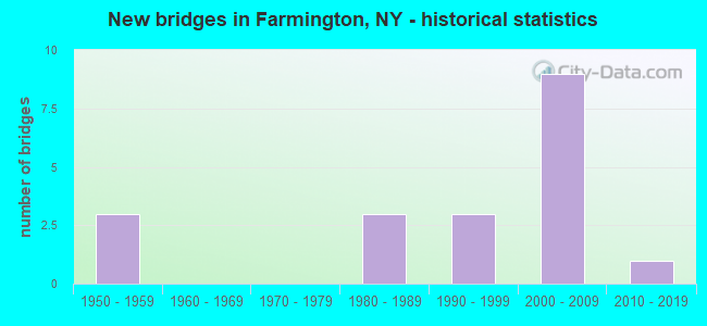
- New bridges - historical statistics
- 31950-1959
- 31980-1989
- 31990-1999
- 92000-2009
- 12010-2019
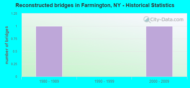
- Reconstructed bridges - Historical Statistics
- 11980-1989
- 01990-1999
- 12000-2009
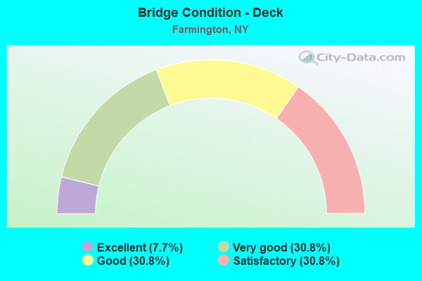
- Bridge Condition - Deck
- 7.7%Excellent
- 30.8%Very good
- 30.8%Good
- 30.8%Satisfactory
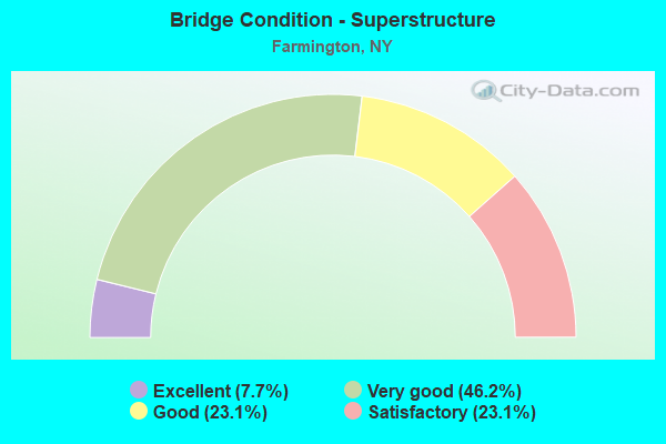
- Bridge Condition - Superstructure
- 7.7%Excellent
- 46.2%Very good
- 23.1%Good
- 23.1%Satisfactory
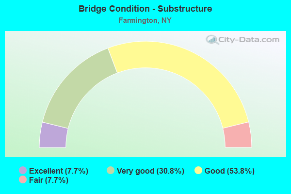
- Bridge Condition - Substructure
- 7.7%Excellent
- 30.8%Very good
- 53.8%Good
- 7.7%Fair
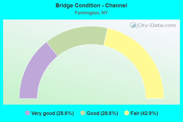
- Bridge Condition - Channel
- 28.6%Very good
- 28.6%Good
- 42.9%Fair
Find on map >> Show street view
Structure Number: 1046051, Location: 1 0 MI N JCT RTS 332& 96 (Lat: 42.986778, Lng: -77.363403), Route carried "on" structure: State highway 332, Year Built: 2000, Status: Open, Structure Length: 4.79m (15.72ft), Average Daily Traffic: 8,552 (year 2018), Truck Traffic: 6%, Average Future Daily Traffic: 8,592 (year 2040), Design Load: HS 25 or greater, Features Intersected: PLASTER MILL ROAD, Finge
Minimum Vertical Clearance: 30+ m (98+ ft), Kilometerpoint: 14.143, Lanes on structure: 2, Lanes under structure: 2, Base Highway Network: Yes, Owner: State Highway Agency, Approaching Roadway Width: 10.7m (35.1ft), Material/Design: Steel, Design/Construction: Stringer/Multi-beam, Number Of Spans In Main Unit: 1, Length of Maximum Span: 46.6m (152.9ft), Curb-To-Curb Width: 10.8m (35.4ft), Out-to-Out Width: 11.6m (38.1ft)
Condition: Deck: Good, Superstructure: Very good, Substructure: Good, Operating Rating: 91.6 metric tons, Method Used To Determine Operating Rating: Load Factor (LF), Inventory Rating: 54.4 metric tons, Method Used To Determine Inventory Rating: Load Factor (LF), Structural Evaluation: Better than present minimum criteria, Deck Geometry: Somewhat better than minimum adequacy, Underclear: Somewhat better than minimum adequacy, Approach Roadway Alignment: Equal to present desirable criteria, Length Of Structure Improvement: 4.78m (15.68ft), Designated Inspection Frequency: Every 24 months, Inspection Date: September 2021, Bridge Improvement Cost: $1,589,000, Roadway Improvement Cost: $930,000, Total Project Cost: $2,519,000 ( Estimate for 2021), Deck Structure Type: Concrete Cast-file-Place, Wearing Surface/Protective System: Wearing Surface: Integral Concrete, Deck Protection: Epoxy Coated Reinforcing
Find on map >> Show street view
Structure Number: 1046052, Location: 1 MI N JCT SH 332 & SH 96 (Lat: 42.986842, Lng: -77.363189), Route carried "on" structure: State highway 332, Year Built: 2001, Status: Open, Structure Length: 4.79m (15.72ft), Average Daily Traffic: 8,552 (year 2018), Truck Traffic: 6%, Average Future Daily Traffic: 8,592 (year 2040), Design Load: HS 25 or greater, Features Intersected: PLASTER MILL ROAD, Finge
Minimum Vertical Clearance: 30+ m (98+ ft), Kilometerpoint: 14.143, Lanes on structure: 2, Lanes under structure: 2, Base Highway Network: Yes, Owner: State Highway Agency, Approaching Roadway Width: 10.4m (34.1ft), Material/Design: Steel, Design/Construction: Stringer/Multi-beam, Number Of Spans In Main Unit: 1, Length of Maximum Span: 46.6m (152.9ft), Curb-To-Curb Width: 10.8m (35.4ft), Out-to-Out Width: 11.6m (38.1ft)
Condition: Deck: Very good, Superstructure: Very good, Substructure: Good, Operating Rating: 41.8 metric tons, Method Used To Determine Operating Rating: Load and Resistance Factor Rating (LRFR) rating reported by rating factor(RF) method using HL-93 loadings, Inventory Rating: 32.1 metric tons, Method Used To Determine Inventory Rating: Load and Resistance Factor Rating (LRFR) rating reported by rating factor(RF) method using HL-93 loadings, Structural Evaluation: Better than present minimum criteria, Deck Geometry: Somewhat better than minimum adequacy, Underclear: Somewhat better than minimum adequacy, Approach Roadway Alignment: Equal to present desirable criteria, Length Of Structure Improvement: 4.78m (15.68ft), Designated Inspection Frequency: Every 24 months, Inspection Date: September 2021, Bridge Improvement Cost: $1,604,000, Roadway Improvement Cost: $939,000, Total Project Cost: $2,543,000 ( Estimate for 2021), Deck Structure Type: Concrete Cast-file-Place, Wearing Surface/Protective System: Wearing Surface: Integral Concrete, Deck Protection: Epoxy Coated Reinforcing
Find on map >> Show street view
Structure Number: 227049, Location: 50 ft S of JCT 41 & Wood (Lat: 42.964381, Lng: -77.327975), Route carried "on" structure: County highway , Year Built: 1981, Status: Open, Structure Length: 0.91m (2.99ft), Average Daily Traffic: 1,533 (year 2020), Average Future Daily Traffic: 2,146 (year 2040), Features Intersected: East Branch of Beaver Cr, Facility Carried by Structure: Wood Road
Minimum Vertical Clearance: 30+ m (98+ ft), Kilometerpoint: 0.306, Lanes on structure: 2, Owner: Town or Township Highway Agency, Approaching Roadway Width: 7.3m (24.0ft), Material/Design: Prestressed concrete, Design/Construction: Box Beam or Girders - Multiple, Number Of Spans In Main Unit: 1, Length of Maximum Span: 8.8m (28.9ft), Curb-To-Curb Width: 8.5m (27.9ft), Out-to-Out Width: 10.4m (34.1ft)
Condition: Deck: Satisfactory, Superstructure: Satisfactory, Substructure: Good, Channel: Fair, Operating Rating: 78.2 metric tons, Method Used To Determine Operating Rating: Field evaluation and documented engineering judgment, Inventory Rating: 29.4 metric tons, Method Used To Determine Inventory Rating: Field evaluation and documented engineering judgment, Structural Evaluation: Equal to present minimum criteria, Deck Geometry: Somewhat better than minimum adequacy, Waterway Adequacy: Better than present minimum criteria, Approach Roadway Alignment: Better than present minimum criteria, Length Of Structure Improvement: 0.88m (2.89ft), Designated Inspection Frequency: Every 24 months, Inspection Date: September 2021, Bridge Improvement Cost: $295,000, Roadway Improvement Cost: $173,000, Total Project Cost: $468,000 ( Estimate for 2021), Deck Structure Type: Concrete Cast-file-Place, Wearing Surface/Protective System: Wearing Surface: Bituminous
Find on map >> Show street view
Structure Number: 331807, Location: 3 MI NE OF VICTOR (Lat: 43.011947, Lng: -77.367983), Route carried "on" structure: Other road , Year Built: 1993, Status: Posted for load-capacity, Structure Length: 2.62m (8.60ft), Average Daily Traffic: 1,914 (year 2020), Truck Traffic: 3%, Average Future Daily Traffic: 1,933 (year 2040), Design Load: HS 25 or greater, Features Intersected: GANARGUA CREEK, Facility Carried by Structure: BROWNSVILLE ROAD
Minimum Vertical Clearance: 30+ m (98+ ft), Kilometerpoint: 0.354, Lanes on structure: 2, Owner: County Highway Agency, Approaching Roadway Width: 7.3m (24.0ft), Material/Design: Prestressed concrete, Design/Construction: Box Beam or Girders - Multiple, Number Of Spans In Main Unit: 1, Length of Maximum Span: 25.6m (84.0ft), Curb-To-Curb Width: 11.9m (39.0ft), Out-to-Out Width: 12.5m (41.0ft)
Condition: Deck: Satisfactory, Superstructure: Satisfactory, Substructure: Good, Channel: Fair, Operating Rating: 71.0 metric tons, Method Used To Determine Operating Rating: Load and Resistance Factor Rating (LRFR) rating reported by rating factor(RF) method using HL-93 loadings, Inventory Rating: 54.1 metric tons, Method Used To Determine Inventory Rating: Load and Resistance Factor Rating (LRFR) rating reported by rating factor(RF) method using HL-93 loadings, Structural Evaluation: Equal to present minimum criteria, Deck Geometry: Equal to present minimum criteria, Waterway Adequacy: Somewhat better than minimum adequacy, Approach Roadway Alignment: Equal to present desirable criteria, Length Of Structure Improvement: 2.62m (8.60ft), Designated Inspection Frequency: Every 24 months, Inspection Date: May 2020, Bridge Improvement Cost: $982,000, Roadway Improvement Cost: $575,000, Total Project Cost: $1,558,000 ( Estimate for 2021), Wearing Surface/Protective System: Wearing Surface: Bituminous
Find on map >> Show street view
Structure Number: 331823, Location: 1 MI W OF FARMINGTON (Lat: 43.032425, Lng: -77.355417), Route carried "on" structure: County highway , Year Built: 2018, Status: Open, Structure Length: 4.63m (15.19ft), Average Daily Traffic: 2,079 (year 2016), Truck Traffic: 5%, Average Future Daily Traffic: 2,911 (year 2036), Design Load: HL 93, Features Intersected: GANARGUA CREEK, Facility Carried by Structure: ALLEN PADGHAM RD
Minimum Vertical Clearance: 30+ m (98+ ft), Kilometerpoint: 2.864, Lanes on structure: 2, Owner: County Highway Agency, Approaching Roadway Width: 10.4m (34.1ft), Material/Design: Steel, Design/Construction: Stringer/Multi-beam, Number Of Spans In Main Unit: 1, Length of Maximum Span: 45.7m (149.9ft), Curb-To-Curb Width: 10.4m (34.1ft), Out-to-Out Width: 11.4m (37.4ft)
Condition: Deck: Excellent, Superstructure: Excellent, Substructure: Excellent, Channel: Very good, Inventory Rating: 66.2 metric tons, Method Used To Determine Inventory Rating: Load Factor (LF), Structural Evaluation: Superior to present desirable criteria, Deck Geometry: Somewhat better than minimum adequacy, Waterway Adequacy: Meets minimum limits, Approach Roadway Alignment: Meets minimum limits, Length Of Structure Improvement: 4.63m (15.19ft), Designated Inspection Frequency: Every 24 months, Inspection Date: October 2020, Bridge Improvement Cost: $1,344,000, Roadway Improvement Cost: $787,000, Total Project Cost: $2,130,000 ( Estimate for 2021), Deck Structure Type: Concrete Cast-file-Place, Wearing Surface/Protective System: Wearing Surface: Integral Concrete, Deck Protection: Epoxy Coated Reinforcing
Find on map >> Show street view
Structure Number: 331876, Location: 0.5 MI W OF MERTENSIA (Lat: 42.961481, Lng: -77.368756), Route carried "on" structure: ServiceCounty highway , Year Built: 1986, Status: Open, Structure Length: 1.34m (4.40ft), Average Daily Traffic: 4,092 (year 2017), Truck Traffic: 5%, Average Future Daily Traffic: 5,063 (year 2040), Design Load: HS 20, Features Intersected: MUD CREEK, Facility Carried by Structure: BOUGHTON HILL RD
Minimum Vertical Clearance: 30+ m (98+ ft), Kilometerpoint: 9.509, Lanes on structure: 2, Owner: County Highway Agency, Approaching Roadway Width: 10.1m (33.1ft), Material/Design: Prestressed concrete, Design/Construction: Box Beam or Girders - Multiple, Number Of Spans In Main Unit: 1, Length of Maximum Span: 13.1m (43.0ft), Curb-To-Curb Width: 11.6m (38.1ft), Out-to-Out Width: 12.5m (41.0ft)
Condition: Deck: Satisfactory, Superstructure: Satisfactory, Substructure: Good, Channel: Good, Operating Rating: 75.2 metric tons, Method Used To Determine Operating Rating: Load and Resistance Factor Rating (LRFR) rating reported by rating factor(RF) method using HL-93 loadings, Inventory Rating: 58.0 metric tons, Method Used To Determine Inventory Rating: Load and Resistance Factor Rating (LRFR) rating reported by rating factor(RF) method using HL-93 loadings, Structural Evaluation: Equal to present minimum criteria, Deck Geometry: Somewhat better than minimum adequacy, Waterway Adequacy: Equal to present minimum criteria, Approach Roadway Alignment: Equal to present desirable criteria, Length Of Structure Improvement: 1.34m (4.40ft), Designated Inspection Frequency: Every 24 months, Inspection Date: April 2021, Bridge Improvement Cost: $658,000, Roadway Improvement Cost: $385,000, Total Project Cost: $1,043,000 ( Estimate for 2021), Wearing Surface/Protective System: Wearing Surface: Bituminous
Find on map >> Show street view
Structure Number: 33508, Location: CITY OF NORWICH (Lat: 42.522381, Lng: -75.513408), Route carried "on" structure: County highway , Year Built: 1986, Status: Open, Structure Length: 5.73m (18.80ft), Average Daily Traffic: 5,387 (year 2018), Truck Traffic: 5%, Average Future Daily Traffic: 6,665 (year 2039), Design Load: HS 20, Features Intersected: CHENANGO RIVER, Facility Carried by Structure: COUNTY ROAD 32A
Minimum Vertical Clearance: 30+ m (98+ ft), Kilometerpoint: 0.531, Lanes on structure: 2, Owner: County Highway Agency, Approaching Roadway Width: 9.1m (29.9ft), Material/Design: Steel continuous, Design/Construction: Stringer/Multi-beam, Number Of Spans In Main Unit: 2, Length of Maximum Span: 27.7m (90.9ft), Curb or Sidewalk Widths: Left: 0.0m, Right: 1.8m (5.9ft), Curb-To-Curb Width: 9.1m (29.9ft), Out-to-Out Width: 11.6m (38.1ft)
Condition: Deck: Good, Superstructure: Very good, Substructure: Good, Channel: Good, Operating Rating: 99.8 metric tons, Method Used To Determine Operating Rating: Load Factor (LF), Inventory Rating: 59.0 metric tons, Method Used To Determine Inventory Rating: Load Factor (LF), Structural Evaluation: Better than present minimum criteria, Deck Geometry: High priority of corrective action, Waterway Adequacy: Meets minimum limits, Approach Roadway Alignment: Equal to present desirable criteria, Length Of Structure Improvement: 5.73m (18.80ft), Designated Inspection Frequency: Every 24 months, Underwater Inspection Frequency: Every 60 months, Inspection Date: October 2020, Underwater Inspection Date: August 2019, Bridge Improvement Cost: $1,482,000, Roadway Improvement Cost: $868,000, Total Project Cost: $2,350,000 ( Estimate for 2021), Deck Structure Type: Concrete Cast-file-Place, Wearing Surface/Protective System: Wearing Surface: Integral Concrete, Deck Protection: Epoxy Coated Reinforcing
Find on map >> Show street view
Structure Number: 33527, Location: AT BURNWOOD (Lat: 41.947581, Lng: -75.060483), Route carried "on" structure: Other road , Year Built: 1956, Year Reconstructed: 2014, Status: Open, Structure Length: 1.92m (6.30ft), Average Daily Traffic: 57 (year 2019), Truck Traffic: 5%, Average Future Daily Traffic: 80 (year 2039), Design Load: HS 20, Features Intersected: TROUT BROOK, Facility Carried by Structure: BURNWOOD ROAD
Minimum Vertical Clearance: 30+ m (98+ ft), Kilometerpoint: 0.322, Lanes on structure: 2, Owner: County Highway Agency, Approaching Roadway Width: 4.9m (16.1ft), Skew: 6 degrees, Material/Design: Steel, Design/Construction: Stringer/Multi-beam, Number Of Spans In Main Unit: 1, Length of Maximum Span: 18.8m (61.7ft), Curb-To-Curb Width: 6.9m (22.6ft), Out-to-Out Width: 7.2m (23.6ft)
Condition: Deck: Very good, Superstructure: Good, Substructure: Fair, Channel: Fair, Operating Rating: 48.1 metric tons, Method Used To Determine Operating Rating: Allowable Stress (AS), Inventory Rating: 31.8 metric tons, Method Used To Determine Inventory Rating: Allowable Stress (AS), Structural Evaluation: Somewhat better than minimum adequacy, Deck Geometry: Somewhat better than minimum adequacy, Waterway Adequacy: Meets minimum limits, Approach Roadway Alignment: Equal to present desirable criteria, Length Of Structure Improvement: 1.92m (6.30ft), Designated Inspection Frequency: Every 24 months, Inspection Date: June 2020, Bridge Improvement Cost: $583,000, Roadway Improvement Cost: $341,000, Total Project Cost: $924,000 ( Estimate for 2021), Deck Structure Type: Wood or Timber, Wearing Surface/Protective System: Wearing Surface: Bituminous, Membrane: Other
Find on map >> Show street view
Structure Number: 337022, Location: .4 MILE WEST OF SH 332 (Lat: 42.962950, Lng: -77.356067), Route carried "on" structure: County highway , Year Built: 2005, Status: Open, Structure Length: 0.70m (2.30ft), Average Daily Traffic: 4,092 (year 2017), Truck Traffic: 5%, Average Future Daily Traffic: 5,063 (year 2040), Design Load: HS 25 or greater, Features Intersected: BEAVER CREEK, Facility Carried by Structure: COUNTY ROAD 41
Minimum Vertical Clearance: 30+ m (98+ ft), Kilometerpoint: 10.571, Lanes on structure: 2, Owner: County Highway Agency, Approaching Roadway Width: 10.4m (34.1ft), Material/Design: Concrete, Design/Construction: Frame, Number Of Spans In Main Unit: 1, Length of Maximum Span: 6.1m (20.0ft), Curb-To-Curb Width: 12.2m (40.0ft), Out-to-Out Width: 13.2m (43.3ft)
Condition: Deck: Very good, Superstructure: Very good, Substructure: Very good, Channel: Very good, Operating Rating: 76.9 metric tons, Method Used To Determine Operating Rating: Field evaluation and documented engineering judgment, Inventory Rating: 40.8 metric tons, Method Used To Determine Inventory Rating: Field evaluation and documented engineering judgment, Structural Evaluation: Equal to present desirable criteria, Deck Geometry: Equal to present minimum criteria, Waterway Adequacy: Superior to present desirable criteria, Approach Roadway Alignment: Equal to present desirable criteria, Length Of Structure Improvement: 0.70m (2.30ft), Designated Inspection Frequency: Every 24 months, Inspection Date: March 2021, Bridge Improvement Cost: $339,000, Roadway Improvement Cost: $198,000, Total Project Cost: $537,000 ( Estimate for 2021)
Find on map >> Show street view
Structure Number: 551063, Location: EXIT 44 90IX (Lat: 42.995753, Lng: -77.367592), Route carried "on" structure: Ramp Interstate , Year Built: 1995, Status: Open, Structure Length: 6.28m (20.60ft), Average Daily Traffic: 11,403 (year 2020), Truck Traffic: 11%, Average Future Daily Traffic: 15,858 (year 2040), Design Load: HS 25 or greater, Features Intersected: 90IX EB, RTE I90, Facility Carried by Structure: EXIT 44 RAMP
Minimum Vertical Clearance: 30+ m (98+ ft), Kilometerpoint: 0.193, Lanes on structure: 2, Lanes under structure: 5, Toll: On Interstate toll segment, Owner: State Toll Authority, Approaching Roadway Width: 14.0m (45.9ft), Skew: 22 degrees, Material/Design: Steel continuous, Design/Construction: Stringer/Multi-beam, Number Of Spans In Main Unit: 2, Length of Maximum Span: 31.4m (103.0ft), Curb-To-Curb Width: 14.4m (47.2ft), Out-to-Out Width: 15.2m (49.9ft)
Condition: Deck: Good, Superstructure: Good, Substructure: Very good, Operating Rating: 70.8 metric tons, Method Used To Determine Operating Rating: Load Factor (LF), Inventory Rating: 40.8 metric tons, Method Used To Determine Inventory Rating: Load Factor (LF), Structural Evaluation: Better than present minimum criteria, Deck Geometry: Superior to present desirable criteria, Underclear: High priority of corrective action, Approach Roadway Alignment: Equal to present desirable criteria, Length Of Structure Improvement: 6.33m (20.77ft), Designated Inspection Frequency: Every 24 months, Inspection Date: June 2021, Bridge Improvement Cost: $2,774,000, Roadway Improvement Cost: $1,624,000, Total Project Cost: $4,398,000 ( Estimate for 2021), Deck Structure Type: Concrete Cast-file-Place, Wearing Surface/Protective System: Wearing Surface: Bituminous, Membrane: Preformed Fabric, Deck Protection: Galvanized Reinforcing
Find on map >> Show street view
Structure Number: 551093, Location: 1.1 MI E OF EXIT 44 90I (Lat: 42.994222, Lng: -77.344994), Route carried "on" structure: Other road , Year Built: 2005, Status: Open, Structure Length: 6.07m (19.91ft), Average Daily Traffic: 2,912 (year 2016), Truck Traffic: 6%, Average Future Daily Traffic: 4,077 (year 2036), Design Load: HS 25 or greater, Features Intersected: 90IX EB, RTE I90, Facility Carried by Structure: HOOK RD
Minimum Vertical Clearance: 30+ m (98+ ft), Kilometerpoint: 2.204, Lanes on structure: 2, Lanes under structure: 4, Owner: State Toll Authority, Approaching Roadway Width: 10.1m (33.1ft), Material/Design: Prestressed concrete, Number Of Spans In Main Unit: 2, Length of Maximum Span: 30.2m (99.1ft), Curb-To-Curb Width: 10.2m (33.5ft), Out-to-Out Width: 13.4m (44.0ft)
Condition: Deck: Very good, Superstructure: Very good, Substructure: Very good, Operating Rating: 94.1 metric tons, Method Used To Determine Operating Rating: Field evaluation and documented engineering judgment, Inventory Rating: 40.8 metric tons, Method Used To Determine Inventory Rating: Field evaluation and documented engineering judgment, Structural Evaluation: Equal to present desirable criteria, Deck Geometry: Meets minimum limits, Underclear: Equal to present minimum criteria, Approach Roadway Alignment: Equal to present desirable criteria, Length Of Structure Improvement: 6.06m (19.88ft), Designated Inspection Frequency: Every 24 months, Inspection Date: November 2021, Bridge Improvement Cost: $2,047,000, Roadway Improvement Cost: $1,198,000, Total Project Cost: $3,245,000 ( Estimate for 2021), Deck Structure Type: Other, Wearing Surface/Protective System: Wearing Surface: Epoxy Overlay
Find on map >> Show street view
Structure Number: 551094, Location: 2.1 MI E OF EXIT 44 90I (Lat: 42.991119, Lng: -77.326264), Route carried "on" structure: County highway , Year Built: 2006, Status: Open, Structure Length: 6.07m (19.91ft), Average Daily Traffic: 2,271 (year 2020), Truck Traffic: 10%, Average Future Daily Traffic: 2,809 (year 2040), Design Load: HS 25 or greater, Features Intersected: 90IX EB, RTE I90, Facility Carried by Structure: CR 8
Minimum Vertical Clearance: 30+ m (98+ ft), Kilometerpoint: 7.852, Lanes on structure: 2, Lanes under structure: 4, Owner: State Toll Authority, Approaching Roadway Width: 10.1m (33.1ft), Skew: 1 degrees, Number Of Spans In Main Unit: 2, Length of Maximum Span: 30.2m (99.1ft), Curb-To-Curb Width: 10.2m (33.5ft), Out-to-Out Width: 13.4m (44.0ft)
Condition: Deck: Good, Superstructure: Very good, Substructure: Very good, Operating Rating: 94.1 metric tons, Method Used To Determine Operating Rating: Field evaluation and documented engineering judgment, Inventory Rating: 40.8 metric tons, Method Used To Determine Inventory Rating: Field evaluation and documented engineering judgment, Structural Evaluation: Equal to present desirable criteria, Deck Geometry: Meets minimum limits, Underclear: Equal to present minimum criteria, Approach Roadway Alignment: Equal to present desirable criteria, Length Of Structure Improvement: 6.06m (19.88ft), Designated Inspection Frequency: Every 24 months, Inspection Date: November 2020, Bridge Improvement Cost: $2,225,000, Roadway Improvement Cost: $1,303,000, Total Project Cost: $3,528,000 ( Estimate for 2021), Deck Structure Type: Other, Wearing Surface/Protective System: Wearing Surface: Epoxy Overlay
Find on map >> Show street view
Structure Number: 551095, Location: 2.3 MI W OF EXIT 43 90I (Lat: 42.980994, Lng: -77.276978), Route carried "on" structure: County highway , Year Built: 1952, Year Reconstructed: 1988, Status: Open, Structure Length: 7.28m (23.88ft), Average Daily Traffic: 3,113 (year 2017), Truck Traffic: 5%, Average Future Daily Traffic: 4,358 (year 2037), Design Load: HS 20+Mod, Features Intersected: 90IX EB, RTE I90, Facility Carried by Structure: CR 28 BLACKSMITH
Minimum Vertical Clearance: 30+ m (98+ ft), Kilometerpoint: 8.640, Lanes on structure: 2, Lanes under structure: 4, Owner: State Toll Authority, Approaching Roadway Width: 8.5m (27.9ft), Skew: 1 degrees, Material/Design: Steel, Design/Construction: Stringer/Multi-beam, Number Of Spans In Main Unit: 4, Length of Maximum Span: 23.2m (76.1ft), Curb-To-Curb Width: 9.4m (30.8ft), Out-to-Out Width: 10.1m (33.1ft)
Condition: Deck: Satisfactory, Superstructure: Good, Substructure: Good, Operating Rating: 55.3 metric tons, Method Used To Determine Operating Rating: Load Factor (LF), Inventory Rating: 32.7 metric tons, Method Used To Determine Inventory Rating: Load Factor (LF), Structural Evaluation: Better than present minimum criteria, Deck Geometry: Meets minimum limits, Underclear: High priority of corrective action, Approach Roadway Alignment: Equal to present desirable criteria, Length Of Structure Improvement: 7.28m (23.88ft), Designated Inspection Frequency: Every 24 months, Inspection Date: September 2021, Bridge Improvement Cost: $1,693,000, Roadway Improvement Cost: $992,000, Total Project Cost: $2,685,000 ( Estimate for 2021), Deck Structure Type: Concrete Cast-file-Place, Wearing Surface/Protective System: Wearing Surface: Integral Concrete, Deck Protection: Epoxy Coated Reinforcing
Find on map >> Show street view
Structure Number: 1046051, Location: 1 0 MI N JCT RTS 332& 96 (Lat: 42.986778, Lng: -77.363403), Route carried "under" structure: County highway , Year Built: 2000, Structure Length: 0. m, Features Intersected: PLASTER MILL ROAD, Finge, Facility Carried by Structure: RTE 332
Minimum Vertical Clearance: 6.32m (20.73ft), Kilometerpoint: 0.000, Lanes on structure: 2, Lanes under structure: 2, Material/Design: Steel, Design/Construction: Stringer/Multi-beam, Length of Maximum Span: 46.6m (152.9ft)
Find on map >> Show street view
Structure Number: 1046052, Location: 1 MI N JCT SH 332 & SH 96 (Lat: 42.986842, Lng: -77.363189), Route carried "under" structure: Other road , Year Built: 2001, Structure Length: 0. m, Features Intersected: PLASTER MILL ROAD, Finge, Facility Carried by Structure: RTE 332
Minimum Vertical Clearance: 6.02m (19.75ft), Kilometerpoint: 0.660, Lanes on structure: 2, Lanes under structure: 2, Material/Design: Steel, Design/Construction: Stringer/Multi-beam, Length of Maximum Span: 46.6m (152.9ft)
Find on map >> Show street view
Structure Number: 551063, Location: EXIT 44 90IX (Lat: 42.995753, Lng: -77.367592), Route carried "under" structure: Interstate 90, Year Built: 1995, Structure Length: 0. m, Average Daily Traffic: 22,670 (year 1977), Features Intersected: 90IX EB, RTE I90, Facility Carried by Structure: EXIT 44 RAMP
Minimum Vertical Clearance: 4.65m (15.26ft), Kilometerpoint: 558.532, Lanes on structure: 2, Lanes under structure: 3, Toll: On Interstate toll segment, Material/Design: Steel continuous, Design/Construction: Stringer/Multi-beam, Length of Maximum Span: 31.4m (103.0ft)
Find on map >> Show street view
Structure Number: 551093, Location: 1.1 MI E OF EXIT 44 90I (Lat: 42.994222, Lng: -77.344994), Route carried "under" structure: Interstate 90, Year Built: 2005, Structure Length: 0. m, Average Daily Traffic: 18,494 (year 1977), Features Intersected: 90IX EB, RTE I90, Facility Carried by Structure: HOOK RD
Minimum Vertical Clearance: 5.61m (18.41ft), Kilometerpoint: 556.682, Lanes on structure: 2, Lanes under structure: 2, Toll: On Interstate toll segment, Material/Design: Prestressed concrete, Length of Maximum Span: 30.2m (99.1ft)
Find on map >> Show street view
Structure Number: 551094, Location: 2.1 MI E OF EXIT 44 90I (Lat: 42.991119, Lng: -77.326264), Route carried "under" structure: Interstate 90, Year Built: 2006, Structure Length: 0. m, Average Daily Traffic: 17,666 (year 1977), Features Intersected: 90IX EB, RTE I90, Facility Carried by Structure: CR 8
Minimum Vertical Clearance: 5.46m (17.91ft), Kilometerpoint: 555.121, Lanes on structure: 2, Lanes under structure: 2, Toll: On Interstate toll segment, Length of Maximum Span: 30.2m (99.1ft)
Find on map >> Show street view
Structure Number: 551095, Location: 2.3 MI W OF EXIT 43 90I (Lat: 42.980994, Lng: -77.276978), Route carried "under" structure: Interstate 90, Year Built: 1952, Structure Length: 0. m, Average Daily Traffic: 17,666 (year 1977), Features Intersected: 90IX EB, RTE I90, Facility Carried by Structure: CR 28 BLACKSMITH
Minimum Vertical Clearance: 4.45m (14.60ft), Kilometerpoint: 550.954, Lanes on structure: 2, Lanes under structure: 2, Toll: On Interstate toll segment, Material/Design: Steel, Design/Construction: Stringer/Multi-beam, Length of Maximum Span: 23.2m (76.1ft)