Bridge Statistics for Fairmount, New York (NY)
Condition, Traffic, Stress, Structural Evaluation, Project Costs
- National Bridge Inventory (NBI) Statistics
- 18Number of bridges
- 203ft / 61.5mTotal length
- $40,312,000Total costs
- 219,619Total average daily traffic
- 7,825Total average daily truck traffic
- National Bridge Inventory (NBI) Registered Bridges for Fairmount
- No street view available for this location
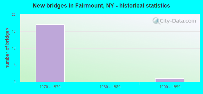
- New bridges - historical statistics
- 171970-1979
- 11990-1999
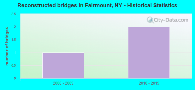
- Reconstructed bridges - Historical Statistics
- 12000-2009
- 22010-2019
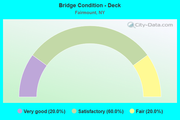
- Bridge Condition - Deck
- 20.0%Very good
- 60.0%Satisfactory
- 20.0%Fair
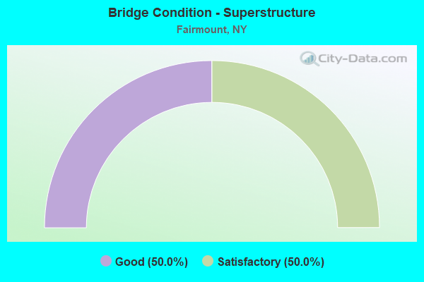
- Bridge Condition - Superstructure
- 50.0%Good
- 50.0%Satisfactory
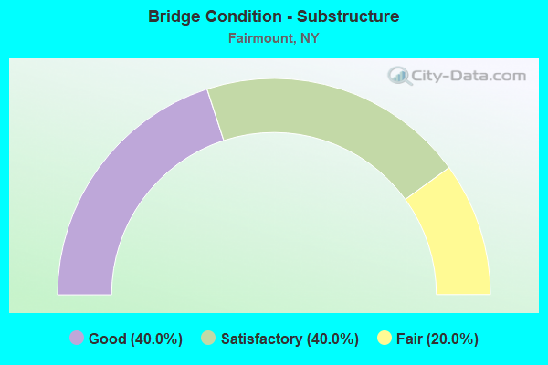
- Bridge Condition - Substructure
- 40.0%Good
- 40.0%Satisfactory
- 20.0%Fair
Find on map >> Show street view
Structure Number: 109339, Location: .3 MI NE JCT SH5 WB&SH173 (Lat: 43.055828, Lng: -76.238006), Route carried "on" structure: Ramp State highway 5, Year Built: 1975, Status: Open, Structure Length: 8.35m (27.40ft), Average Daily Traffic: 13,015 (year 2014), Truck Traffic: 4%, Average Future Daily Traffic: 16,955 (year 2040), Design Load: HS 20, Features Intersected: ROADWAY A
Minimum Vertical Clearance: 30+ m (98+ ft), Kilometerpoint: 22.671, Lanes on structure: 2, Lanes under structure: 2, Base Highway Network: Yes, Owner: State Highway Agency, Approaching Roadway Width: 12.5m (41.0ft), Skew: 5 degrees, Material/Design: Steel, Design/Construction: Stringer/Multi-beam, Number Of Spans In Main Unit: 2, Length of Maximum Span: 49.0m (160.8ft), Curb-To-Curb Width: 12.5m (41.0ft), Out-to-Out Width: 13.4m (44.0ft)
Condition: Deck: Satisfactory, Superstructure: Good, Substructure: Satisfactory, Operating Rating: 96.7 metric tons, Method Used To Determine Operating Rating: Field evaluation and documented engineering judgment, Inventory Rating: 32.7 metric tons, Method Used To Determine Inventory Rating: Field evaluation and documented engineering judgment, Structural Evaluation: Equal to present minimum criteria, Deck Geometry: Superior to present desirable criteria, Underclear: High priority of corrective action, Approach Roadway Alignment: Equal to present desirable criteria, Length Of Structure Improvement: 8.35m (27.40ft), Designated Inspection Frequency: Every 24 months, Inspection Date: November 2020, Bridge Improvement Cost: $2,773,000, Roadway Improvement Cost: $1,624,000, Total Project Cost: $4,397,000 ( Estimate for 2021), Deck Structure Type: Concrete Cast-file-Place, Wearing Surface/Protective System: Wearing Surface: Latex Concrete
Find on map >> Show street view
Structure Number: 10934, Location: INT .4MI NE JCT RTS 5+173 (Lat: 43.057639, Lng: -76.236831), Route carried "on" structure: Ramp State highway 695, Year Built: 1975, Status: Open, Structure Length: 4.75m (15.58ft), Average Daily Traffic: 38,213 (year 2020), Truck Traffic: 4%, Average Future Daily Traffic: 49,783 (year 2040), Design Load: HS 20, Features Intersected: ROADWAY A
Minimum Vertical Clearance: 30+ m (98+ ft), Kilometerpoint: 1.126, Lanes on structure: 2, Lanes under structure: 2, Base Highway Network: Yes, Owner: State Highway Agency, Approaching Roadway Width: 13.4m (44.0ft), Skew: 4 degrees, Material/Design: Steel, Design/Construction: Stringer/Multi-beam, Number Of Spans In Main Unit: 1, Length of Maximum Span: 46.9m (153.9ft), Curb-To-Curb Width: 12.5m (41.0ft), Out-to-Out Width: 13.4m (44.0ft)
Condition: Deck: Fair, Superstructure: Good, Substructure: Satisfactory, Inventory Rating: 32.7 metric tons, Method Used To Determine Inventory Rating: Field evaluation and documented engineering judgment, Structural Evaluation: Equal to present minimum criteria, Deck Geometry: Superior to present desirable criteria, Underclear: High priority of corrective action, Approach Roadway Alignment: Equal to present desirable criteria, Length Of Structure Improvement: 4.75m (15.58ft), Designated Inspection Frequency: Every 24 months, Inspection Date: September 2020, Bridge Improvement Cost: $1,806,000, Roadway Improvement Cost: $1,057,000, Total Project Cost: $2,863,000 ( Estimate for 2021), Deck Structure Type: Concrete Cast-file-Place, Wearing Surface/Protective System: Wearing Surface: Latex Concrete
Find on map >> Show street view
Structure Number: 109341, Location: INT .4MI NE JCT RTS 5+173 (Lat: 43.056333, Lng: -76.235658), Route carried "on" structure: Ramp State highway 695, Year Built: 1975, Status: Open, Structure Length: 4.11m (13.48ft), Average Daily Traffic: 38,213 (year 2020), Truck Traffic: 4%, Average Future Daily Traffic: 49,783 (year 2040), Design Load: HS 20, Features Intersected: ROADWAY BD
Minimum Vertical Clearance: 30+ m (98+ ft), Kilometerpoint: 0.981, Lanes on structure: 2, Lanes under structure: 2, Base Highway Network: Yes, Owner: State Highway Agency, Approaching Roadway Width: 12.5m (41.0ft), Skew: 4 degrees, Material/Design: Steel, Design/Construction: Stringer/Multi-beam, Number Of Spans In Main Unit: 1, Length of Maximum Span: 40.5m (132.9ft), Curb-To-Curb Width: 12.5m (41.0ft), Out-to-Out Width: 13.4m (44.0ft)
Condition: Deck: Satisfactory, Superstructure: Good, Substructure: Satisfactory, Inventory Rating: 32.7 metric tons, Method Used To Determine Inventory Rating: Field evaluation and documented engineering judgment, Structural Evaluation: Equal to present minimum criteria, Deck Geometry: Superior to present desirable criteria, Underclear: High priority of corrective action, Approach Roadway Alignment: Equal to present desirable criteria, Length Of Structure Improvement: 4.11m (13.48ft), Designated Inspection Frequency: Every 24 months, Inspection Date: October 2020, Bridge Improvement Cost: $1,614,000, Roadway Improvement Cost: $945,000, Total Project Cost: $2,559,000 ( Estimate for 2021), Deck Structure Type: Concrete Cast-file-Place, Wearing Surface/Protective System: Wearing Surface: Integral Concrete, Deck Protection: Epoxy Coated Reinforcing
Find on map >> Show street view
Structure Number: 1093421, Location: JCT OF RTS 5 WB + 297 (Lat: 43.055908, Lng: -76.232678), Route carried "on" structure: Ramp State highway 695, Year Built: 1975, Year Reconstructed: 2017, Status: Open, Structure Length: 7.99m (26.21ft), Average Daily Traffic: 2,658 (year 2017), Truck Traffic: 4%, Average Future Daily Traffic: 3,462 (year 2040), Design Load: HS 20, Features Intersected: RTE 297, FINGER LAKES RR
Minimum Vertical Clearance: 30+ m (98+ ft), Kilometerpoint: 0.000, Lanes on structure: 4, Lanes under structure: 2, Owner: State Highway Agency, Approaching Roadway Width: 19.8m (65.0ft), Skew: 2 degrees, Material/Design: Steel, Design/Construction: Stringer/Multi-beam, Number Of Spans In Main Unit: 3, Length of Maximum Span: 29.8m (97.8ft), Curb-To-Curb Width: 19.8m (65.0ft), Out-to-Out Width: 20.7m (67.9ft)
Condition: Deck: Satisfactory, Superstructure: Satisfactory, Substructure: Good, Operating Rating: 69.9 metric tons, Method Used To Determine Operating Rating: Load Factor (LF), Inventory Rating: 41.7 metric tons, Method Used To Determine Inventory Rating: Load Factor (LF), Structural Evaluation: Equal to present minimum criteria, Deck Geometry: Superior to present desirable criteria, Underclear: Somewhat better than minimum adequacy, Approach Roadway Alignment: Equal to present desirable criteria, Length Of Structure Improvement: 7.98m (26.18ft), Designated Inspection Frequency: Every 24 months, Inspection Date: July 2021, Bridge Improvement Cost: $3,455,000, Roadway Improvement Cost: $2,023,000, Total Project Cost: $5,479,000 ( Estimate for 2021), Deck Structure Type: Concrete Cast-file-Place, Wearing Surface/Protective System: Wearing Surface: Epoxy Overlay
Find on map >> Show street view
Structure Number: 1093422, Location: JCT OF RTS 5 EB + 297 (Lat: 43.055475, Lng: -76.233308), Route carried "on" structure: Ramp State highway 695, Year Built: 1975, Year Reconstructed: 2017, Status: Open, Structure Length: 8.81m (28.90ft), Average Daily Traffic: 19,107 (year 2020), Truck Traffic: 4%, Average Future Daily Traffic: 24,892 (year 2040), Design Load: HS 20, Features Intersected: RTE 297, FINGER LAKES RR
Minimum Vertical Clearance: 30+ m (98+ ft), Kilometerpoint: 0.772, Lanes on structure: 4, Lanes under structure: 2, Base Highway Network: Yes, Owner: State Highway Agency, Approaching Roadway Width: 19.8m (65.0ft), Skew: 3 degrees, Material/Design: Steel, Design/Construction: Stringer/Multi-beam, Number Of Spans In Main Unit: 3, Length of Maximum Span: 31.6m (103.7ft), Curb-To-Curb Width: 19.8m (65.0ft), Out-to-Out Width: 20.7m (67.9ft)
Condition: Deck: Satisfactory, Superstructure: Satisfactory, Substructure: Good, Operating Rating: 68.0 metric tons, Method Used To Determine Operating Rating: Load Factor (LF), Inventory Rating: 40.8 metric tons, Method Used To Determine Inventory Rating: Load Factor (LF), Structural Evaluation: Equal to present minimum criteria, Deck Geometry: Superior to present desirable criteria, Underclear: Somewhat better than minimum adequacy, Approach Roadway Alignment: Equal to present desirable criteria, Length Of Structure Improvement: 8.80m (28.87ft), Designated Inspection Frequency: Every 24 months, Inspection Date: July 2021, Bridge Improvement Cost: $3,787,000, Roadway Improvement Cost: $2,218,000, Total Project Cost: $6,005,000 ( Estimate for 2021), Deck Structure Type: Concrete Cast-file-Place, Wearing Surface/Protective System: Wearing Surface: Epoxy Overlay
Find on map >> Show street view
Structure Number: 109346, Location: 1.8 MI W JCT SH 5 & SH173 (Lat: 43.054250, Lng: -76.278308), Route carried "on" structure: County highway , Year Built: 1977, Status: Open, Structure Length: 5.12m (16.80ft), Average Daily Traffic: 5,701 (year 2020), Truck Traffic: 3%, Average Future Daily Traffic: 6,925 (year 2040), Design Load: HS 20, Features Intersected: RTE 5, Facility Carried by Structure: BENNETT ROAD
Minimum Vertical Clearance: 30+ m (98+ ft), Kilometerpoint: 0.145, Lanes on structure: 2, Lanes under structure: 6, Owner: State Highway Agency, Approaching Roadway Width: 13.1m (43.0ft), Skew: 1 degrees, Material/Design: Steel, Design/Construction: Stringer/Multi-beam, Number Of Spans In Main Unit: 1, Length of Maximum Span: 50.5m (165.7ft), Curb-To-Curb Width: 15.5m (50.9ft), Out-to-Out Width: 16.5m (54.1ft)
Condition: Deck: Satisfactory, Superstructure: Satisfactory, Substructure: Fair, Operating Rating: 74.4 metric tons, Method Used To Determine Operating Rating: Load Factor (LF), Inventory Rating: 35.4 metric tons, Method Used To Determine Inventory Rating: Load Factor (LF), Structural Evaluation: Somewhat better than minimum adequacy, Deck Geometry: Superior to present desirable criteria, Underclear: High priority of corrective action, Approach Roadway Alignment: Equal to present desirable criteria, Length Of Structure Improvement: 5.12m (16.80ft), Designated Inspection Frequency: Every 24 months, Inspection Date: July 2020, Bridge Improvement Cost: $2,336,000, Roadway Improvement Cost: $1,368,000, Total Project Cost: $3,704,000 ( Estimate for 2021), Deck Structure Type: Concrete Cast-file-Place, Wearing Surface/Protective System: Wearing Surface: Integral Concrete
Find on map >> Show street view
Structure Number: 1093479, Location: 1.2 MI W JCT SH 5 & SH173 (Lat: 43.054689, Lng: -76.265817), Route carried "on" structure: State highway 5, Year Built: 1977, Status: Open, Structure Length: 3.47m (11.38ft), Average Daily Traffic: 21,068 (year 2009), Truck Traffic: 8%, Average Future Daily Traffic: 27,447 (year 2040), Design Load: HS 20, Features Intersected: CR209-HINSDALE RD
Minimum Vertical Clearance: 30+ m (98+ ft), Kilometerpoint: 20.289, Lanes on structure: 6, Lanes under structure: 3, Base Highway Network: Yes, Owner: State Highway Agency, Approaching Roadway Width: 35.4m (116.1ft), Skew: 20 degrees, Material/Design: Steel, Design/Construction: Stringer/Multi-beam, Number Of Spans In Main Unit: 1, Length of Maximum Span: 33.5m (109.9ft), Curb-To-Curb Width: 35.4m (116.1ft), Out-to-Out Width: 37.2m (122.0ft)
Condition: Deck: Satisfactory, Superstructure: Good, Substructure: Good, Operating Rating: 56.1 metric tons, Method Used To Determine Operating Rating: Load and Resistance Factor Rating (LRFR) rating reported by rating factor(RF) method using HL-93 loadings, Inventory Rating: 43.1 metric tons, Method Used To Determine Inventory Rating: Load and Resistance Factor Rating (LRFR) rating reported by rating factor(RF) method using HL-93 loadings, Structural Evaluation: Better than present minimum criteria, Deck Geometry: Superior to present desirable criteria, Underclear: Meets minimum limits, Approach Roadway Alignment: Equal to present desirable criteria, Length Of Structure Improvement: 3.47m (11.38ft), Designated Inspection Frequency: Every 24 months, Inspection Date: April 2020, Bridge Improvement Cost: $3,447,000, Roadway Improvement Cost: $2,018,000, Total Project Cost: $5,465,000 ( Estimate for 2021), Deck Structure Type: Concrete Cast-file-Place, Wearing Surface/Protective System: Wearing Surface: Integral Concrete
Find on map >> Show street view
Structure Number: 109348, Location: JCT OF RTS 173 + 5 (Lat: 43.052994, Lng: -76.243631), Route carried "on" structure: State highway 173, Year Built: 1975, Status: Open, Structure Length: 10.45m (34.28ft), Average Daily Traffic: 7,177 (year 2020), Truck Traffic: 5%, Average Future Daily Traffic: 8,718 (year 2040), Design Load: HS 20, Features Intersected: 5 5 33091336 EB, RTE 5
Minimum Vertical Clearance: 30+ m (98+ ft), Kilometerpoint: 13.323, Lanes on structure: 2, Lanes under structure: 7, Base Highway Network: Yes, Owner: State Highway Agency, Approaching Roadway Width: 14.6m (47.9ft), Skew: 4 degrees, Material/Design: Steel, Design/Construction: Stringer/Multi-beam, Number Of Spans In Main Unit: 3, Length of Maximum Span: 40.8m (133.9ft), Curb-To-Curb Width: 14.3m (46.9ft), Out-to-Out Width: 15.2m (49.9ft)
Condition: Deck: Fair, Superstructure: Satisfactory, Substructure: Fair, Operating Rating: 67.1 metric tons, Method Used To Determine Operating Rating: Load Factor (LF), Inventory Rating: 39.0 metric tons, Method Used To Determine Inventory Rating: Load Factor (LF), Structural Evaluation: Somewhat better than minimum adequacy, Deck Geometry: Superior to present desirable criteria, Underclear: High priority of corrective action, Approach Roadway Alignment: Equal to present desirable criteria, Length Of Structure Improvement: 10.45m (34.28ft), Designated Inspection Frequency: Every 24 months, Inspection Date: October 2020, Bridge Improvement Cost: $3,381,000, Roadway Improvement Cost: $1,980,000, Total Project Cost: $5,361,000 ( Estimate for 2021), Deck Structure Type: Concrete Cast-file-Place, Wearing Surface/Protective System: Wearing Surface: Integral Concrete
Find on map >> Show street view
Structure Number: 309349, Location: .1 MI SE JCT SH 173 & SH5 (Lat: 43.052219, Lng: -76.242336), Route carried "on" structure: State highway 173, Year Built: 1975, Year Reconstructed: 2009, Status: Open, Structure Length: 6.46m (21.19ft), Average Daily Traffic: 7,177 (year 2020), Truck Traffic: 5%, Average Future Daily Traffic: 8,718 (year 2040), Design Load: HS 20, Features Intersected: FINGER LAKES
Minimum Vertical Clearance: 30+ m (98+ ft), Kilometerpoint: 13.483, Lanes on structure: 2, Base Highway Network: Yes, Owner: County Highway Agency, Approaching Roadway Width: 14.3m (46.9ft), Skew: 4 degrees, Material/Design: Steel, Design/Construction: Stringer/Multi-beam, Number Of Spans In Main Unit: 3, Length of Maximum Span: 23.5m (77.1ft), Curb-To-Curb Width: 14.3m (46.9ft), Out-to-Out Width: 15.2m (49.9ft)
Condition: Deck: Very good, Superstructure: Satisfactory, Substructure: Satisfactory, Operating Rating: 51.5 metric tons, Method Used To Determine Operating Rating: Load and Resistance Factor Rating (LRFR) rating reported by rating factor(RF) method using HL-93 loadings, Inventory Rating: 39.9 metric tons, Method Used To Determine Inventory Rating: Load and Resistance Factor Rating (LRFR) rating reported by rating factor(RF) method using HL-93 loadings, Structural Evaluation: Equal to present minimum criteria, Deck Geometry: Superior to present desirable criteria, Underclear: Somewhat better than minimum adequacy, Approach Roadway Alignment: Equal to present desirable criteria, Length Of Structure Improvement: 6.46m (21.19ft), Designated Inspection Frequency: Every 24 months, Inspection Date: October 2021, Bridge Improvement Cost: $2,105,000, Roadway Improvement Cost: $1,233,000, Total Project Cost: $3,337,000 ( Estimate for 2021), Deck Structure Type: Concrete Cast-file-Place, Wearing Surface/Protective System: Wearing Surface: Integral Concrete
Find on map >> Show street view
Structure Number: 331316, Location: IN AMBOY (Lat: 43.069906, Lng: -76.273219), Route carried "on" structure: State highway 173, Year Built: 1993, Status: Open, Structure Length: 2.04m (6.69ft), Average Daily Traffic: 3,290 (year 2018), Truck Traffic: 3%, Average Future Daily Traffic: 4,070 (year 2040), Design Load: HS 25 or greater, Features Intersected: NINEMILE CREEK
Minimum Vertical Clearance: 30+ m (98+ ft), Kilometerpoint: 10.072, Lanes on structure: 2, Base Highway Network: Yes, Owner: County Highway Agency, Approaching Roadway Width: 10.4m (34.1ft), Material/Design: Steel, Design/Construction: Stringer/Multi-beam, Number Of Spans In Main Unit: 1, Length of Maximum Span: 18.8m (61.7ft), Curb-To-Curb Width: 10.4m (34.1ft), Out-to-Out Width: 11.0m (36.1ft)
Condition: Deck: Very good, Superstructure: Good, Substructure: Good, Channel: Good, Operating Rating: 96.2 metric tons, Method Used To Determine Operating Rating: Load Factor (LF), Inventory Rating: 57.2 metric tons, Method Used To Determine Inventory Rating: Load Factor (LF), Structural Evaluation: Better than present minimum criteria, Deck Geometry: Somewhat better than minimum adequacy, Waterway Adequacy: Somewhat better than minimum adequacy, Approach Roadway Alignment: Equal to present desirable criteria, Length Of Structure Improvement: 2.04m (6.69ft), Designated Inspection Frequency: Every 24 months, Inspection Date: August 2021, Bridge Improvement Cost: $720,000, Roadway Improvement Cost: $422,000, Total Project Cost: $1,142,000 ( Estimate for 2021), Deck Structure Type: Concrete Cast-file-Place, Wearing Surface/Protective System: Wearing Surface: Bituminous, Membrane: Other, Deck Protection: Epoxy Coated Reinforcing
Find on map >> Show street view
Structure Number: 109339, Location: .3 MI NE JCT SH5 WB&SH173 (Lat: 43.055828, Lng: -76.238006), Route carried "under" structure: Spur State highway , Year Built: 1975, Structure Length: 0. m, Average Daily Traffic: 5,350 (year 1975), Features Intersected: ROADWAY A, Facility Carried by Structure: RTE 5
Minimum Vertical Clearance: 5.02m (16.47ft), Kilometerpoint: 0.000, Lanes on structure: 2, Lanes under structure: 2, Material/Design: Steel, Design/Construction: Stringer/Multi-beam, Length of Maximum Span: 49.0m (160.8ft)
Find on map >> Show street view
Structure Number: 10934, Location: INT .4MI NE JCT RTS 5+173 (Lat: 43.057639, Lng: -76.236831), Route carried "under" structure: Spur State highway , Year Built: 1975, Structure Length: 0. m, Average Daily Traffic: 1,000 (year 1975), Features Intersected: ROADWAY A, Facility Carried by Structure: RTE 695
Minimum Vertical Clearance: 4.47m (14.67ft), Kilometerpoint: 0.000, Lanes on structure: 2, Lanes under structure: 2, Material/Design: Steel, Design/Construction: Stringer/Multi-beam, Length of Maximum Span: 46.9m (153.9ft)
Find on map >> Show street view
Structure Number: 109341, Location: INT .4MI NE JCT RTS 5+173 (Lat: 43.056333, Lng: -76.235658), Route carried "under" structure: Spur State highway , Year Built: 1975, Structure Length: 0. m, Average Daily Traffic: 1,000 (year 2021), Features Intersected: ROADWAY BD, Facility Carried by Structure: RTE 695
Minimum Vertical Clearance: 4.59m (15.06ft), Kilometerpoint: 8.367, Lanes on structure: 2, Lanes under structure: 2, Material/Design: Steel, Design/Construction: Stringer/Multi-beam, Length of Maximum Span: 40.5m (132.9ft)
Find on map >> Show street view
Structure Number: 1093421, Location: JCT OF RTS 5 WB + 297 (Lat: 43.055908, Lng: -76.232678), Route carried "under" structure: State highway 297, Year Built: 1975, Structure Length: 0. m, Average Daily Traffic: 8,448 (year 2002), Features Intersected: RTE 297, FINGER LAKES RR, Facility Carried by Structure: RTE 695
Minimum Vertical Clearance: 7.62m (25.00ft), Kilometerpoint: 0.805, Lanes on structure: 4, Lanes under structure: 2, Material/Design: Steel, Design/Construction: Stringer/Multi-beam, Length of Maximum Span: 29.8m (97.8ft)
Find on map >> Show street view
Structure Number: 1093422, Location: JCT OF RTS 5 EB + 297 (Lat: 43.055475, Lng: -76.233308), Route carried "under" structure: State highway 297, Year Built: 1975, Structure Length: 0. m, Average Daily Traffic: 8,448 (year 2002), Features Intersected: RTE 297, FINGER LAKES RR, Facility Carried by Structure: RTE 695
Minimum Vertical Clearance: 9.99m (32.78ft), Kilometerpoint: 0.805, Lanes on structure: 4, Lanes under structure: 2, Material/Design: Steel, Design/Construction: Stringer/Multi-beam, Length of Maximum Span: 31.6m (103.7ft)
Find on map >> Show street view
Structure Number: 109346, Location: 1.8 MI W JCT SH 5 & SH173 (Lat: 43.054250, Lng: -76.278308), Route carried "under" structure: State highway 5, Year Built: 1977, Structure Length: 0. m, Average Daily Traffic: 9,849 (year 1979), Features Intersected: RTE 5, Facility Carried by Structure: BENNETT ROAD
Minimum Vertical Clearance: 4.67m (15.32ft), Kilometerpoint: 51.054, Lanes on structure: 2, Lanes under structure: 6, Material/Design: Steel, Design/Construction: Stringer/Multi-beam, Length of Maximum Span: 50.5m (165.7ft)
Find on map >> Show street view
Structure Number: 1093479, Location: 1.2 MI W JCT SH 5 & SH173 (Lat: 43.054689, Lng: -76.265817), Route carried "under" structure: County highway , Year Built: 1977, Structure Length: 0. m, Average Daily Traffic: 14,185 (year 2015), Truck Traffic: 5%, Features Intersected: CR209-HINSDALE RD, Facility Carried by Structure: RTE 5
Minimum Vertical Clearance: 4.92m (16.14ft), Kilometerpoint: 1.448, Lanes on structure: 6, Lanes under structure: 3, Material/Design: Steel, Design/Construction: Stringer/Multi-beam, Length of Maximum Span: 33.5m (109.9ft)
Find on map >> Show street view
Structure Number: 109348, Location: JCT OF RTS 173 + 5 (Lat: 43.052994, Lng: -76.243631), Route carried "under" structure: State highway 5, Year Built: 1975, Structure Length: 0. m, Average Daily Traffic: 15,720 (year 1979), Features Intersected: 5 5 33091336 EB, RTE 5, Facility Carried by Structure: RTE 173
Minimum Vertical Clearance: 6.68m (21.92ft), Kilometerpoint: 53.885, Lanes on structure: 2, Lanes under structure: 4, Material/Design: Steel, Design/Construction: Stringer/Multi-beam, Length of Maximum Span: 40.8m (133.9ft)