Bridge Statistics for Fairlawn, Ohio (OH)
Condition, Traffic, Stress, Structural Evaluation, Project Costs
- National Bridge Inventory (NBI) Statistics
- 20Number of bridges
- 210ft / 63.9mTotal length
- 480,765Total average daily traffic
- 28,719Total average daily truck traffic
- National Bridge Inventory (NBI) Registered Bridges for Fairlawn
- No street view available for this location
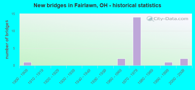
- New bridges - historical statistics
- 11900-1909
- 21960-1969
- 141970-1979
- 11990-1999
- 22000-2009

- Reconstructed bridges - Historical Statistics
- 11980-1989
- 01990-1999
- 62000-2009


- Bridge Condition - Deck
- 66.7%Very good
- 11.1%Satisfactory
- 22.2%Fair

- Bridge Condition - Superstructure
- 55.6%Very good
- 11.1%Good
- 33.3%Satisfactory

- Bridge Condition - Substructure
- 44.4%Very good
- 55.6%Good

- Bridge Condition - Culverts
- 50.0%Very good
- 50.0%Satisfactory
Find on map >> Show street view
Structure Number: 7701756, Location: 1.48 MI N OF SR 162 (Lat: 41.120739, Lng: -81.653639), Route carried "on" structure: Ramp Interstate 77, Year Built: 1972, Year Reconstructed: 1994, Status: Open, Structure Length: 6.86m (22.51ft), Average Daily Traffic: 2,290 (year 1992), Truck Traffic: 8%, Average Future Daily Traffic: 21,397 (year 2012), Design Load: HS 20+Mod, Features Intersected: SR 21
Minimum Vertical Clearance: 30+ m (98+ ft), Kilometerpoint: 35.808, Lanes on structure: 1, Lanes under structure: 5, Owner: State Highway Agency, Approaching Roadway Width: 10.1m (33.1ft), Material/Design: Steel continuous, Design/Construction: Stringer/Multi-beam, Number Of Spans In Main Unit: 3, Length of Maximum Span: 28.0m (91.9ft), Curb-To-Curb Width: 8.8m (28.9ft), Out-to-Out Width: 9.8m (32.2ft)
Condition: Deck: Satisfactory, Superstructure: Satisfactory, Substructure: Good, Operating Rating: 42.1 metric tons, Method Used To Determine Operating Rating: Load Factor (LF) rating reported by rating factor (RF) method using MS18 loading, Inventory Rating: 32.4 metric tons, Method Used To Determine Inventory Rating: Load Factor (LF) rating reported by rating factor (RF) method using MS18 loading, Structural Evaluation: Equal to present minimum criteria, Deck Geometry: Superior to present desirable criteria, Underclear: High priority of corrective action, Approach Roadway Alignment: Equal to present desirable criteria, Designated Inspection Frequency: Every 12 months, Inspection Date: July 2021, Deck Structure Type: Concrete Cast-file-Place, Wearing Surface/Protective System: Wearing Surface: Monolithic Concrete, Deck Protection: Epoxy Coated Reinforcing
Find on map >> Show street view
Structure Number: 7703953, Location: 2.81 MI N OF SR 162 (Lat: 41.113761, Lng: -81.611850), Route carried "on" structure: County highway C0083, Year Built: 1971, Year Reconstructed: 2008, Status: Open, Structure Length: 7.68m (25.20ft), Average Daily Traffic: 29,755 (year 2015), Truck Traffic: 3%, Average Future Daily Traffic: 89,917 (year 2035), Design Load: HS 20, Features Intersected: IR 77, Facility Carried by Structure: RIDGEWOOD RD CR 8
Minimum Vertical Clearance: 30+ m (98+ ft), Kilometerpoint: 6.775, Lanes on structure: 5, Lanes under structure: 6, Owner: State Highway Agency, Approaching Roadway Width: 14.6m (47.9ft), Skew: 2 degrees, Material/Design: Steel continuous, Design/Construction: Stringer/Multi-beam, Number Of Spans In Main Unit: 4, Length of Maximum Span: 21.6m (70.9ft), Curb or Sidewalk Widths: Left: 1.2m (3.9ft), Right: 1.2m (3.9ft), Curb-To-Curb Width: 14.6m (47.9ft), Out-to-Out Width: 17.7m (58.1ft)
Condition: Deck: Very good, Superstructure: Very good, Substructure: Very good, Operating Rating: 42.1 metric tons, Method Used To Determine Operating Rating: Load Factor (LF) rating reported by rating factor (RF) method using MS18 loading, Inventory Rating: 32.4 metric tons, Method Used To Determine Inventory Rating: Load Factor (LF) rating reported by rating factor (RF) method using MS18 loading, Structural Evaluation: Equal to present desirable criteria, Deck Geometry: High priority of replacement, Underclear: High priority of corrective action, Approach Roadway Alignment: Equal to present desirable criteria, Designated Inspection Frequency: Every 24 months, Inspection Date: June 2021, Deck Structure Type: Concrete Cast-file-Place, Wearing Surface/Protective System: Wearing Surface: Monolithic Concrete
Find on map >> Show street view
Structure Number: 7703988, Location: 1.39 MI W OF SR 21 (Lat: 41.119150, Lng: -81.627811), Route carried "on" structure: City street M2558, Year Built: 1971, Year Reconstructed: 2007, Status: Open, Structure Length: 8.14m (26.71ft), Average Daily Traffic: 1,295 (year 2015), Truck Traffic: 5%, Average Future Daily Traffic: 98,458 (year 2035), Design Load: H 15, Features Intersected: IR 77, Facility Carried by Structure: I.R. 77
Minimum Vertical Clearance: 30+ m (98+ ft), Kilometerpoint: 0.000, Lanes on structure: 2, Lanes under structure: 6, Owner: State Highway Agency, Approaching Roadway Width: 7.3m (24.0ft), Skew: 3 degrees, Material/Design: Steel continuous, Design/Construction: Stringer/Multi-beam, Number Of Spans In Main Unit: 4, Length of Maximum Span: 24.4m (80.1ft), Curb or Sidewalk Widths: Left: 1.2m (3.9ft), Right: 0.0m, Curb-To-Curb Width: 7.3m (24.0ft), Out-to-Out Width: 10.4m (34.1ft)
Condition: Deck: Very good, Superstructure: Very good, Substructure: Good, Operating Rating: 42.1 metric tons, Method Used To Determine Operating Rating: Load Factor (LF) rating reported by rating factor (RF) method using MS18 loading, Inventory Rating: 32.4 metric tons, Method Used To Determine Inventory Rating: Load Factor (LF) rating reported by rating factor (RF) method using MS18 loading, Structural Evaluation: Better than present minimum criteria, Deck Geometry: Meets minimum limits, Underclear: High priority of corrective action, Approach Roadway Alignment: Equal to present desirable criteria, Designated Inspection Frequency: Every 24 months, Inspection Date: July 2021, Deck Structure Type: Concrete Cast-file-Place, Wearing Surface/Protective System: Wearing Surface: Monolithic Concrete
Find on map >> Show street view
Structure Number: 7704003, Location: 1.10 MI S OF SR 21 (Lat: 41.119181, Lng: -81.638981), Route carried "on" structure: Interstate 77, Year Built: 1971, Year Reconstructed: 2008, Status: Open, Structure Length: 4.51m (14.80ft), Average Daily Traffic: 28,156 (year 2015), Truck Traffic: 6%, Average Future Daily Traffic: 39,081 (year 2035), Design Load: HS 20+Mod, Features Intersected: OVER CLEV MASS RD CR-17
Minimum Vertical Clearance: 30+ m (98+ ft), Kilometerpoint: 34.601, Lanes on structure: 3, Lanes under structure: 3, Base Highway Network: Yes, Owner: State Highway Agency, Approaching Roadway Width: 12.5m (41.0ft), Skew: 2 degrees, Material/Design: Steel continuous, Design/Construction: Stringer/Multi-beam, Number Of Spans In Main Unit: 3, Length of Maximum Span: 22.3m (73.2ft), Curb-To-Curb Width: 12.5m (41.0ft), Out-to-Out Width: 13.4m (44.0ft)
Condition: Deck: Very good, Superstructure: Very good, Substructure: Very good, Operating Rating: 58.3 metric tons, Method Used To Determine Operating Rating: Load and Resistance Factor Rating (LRFR) rating reported by rating factor(RF) method using HL-93 loadings, Inventory Rating: 45.4 metric tons, Method Used To Determine Inventory Rating: Load and Resistance Factor Rating (LRFR) rating reported by rating factor(RF) method using HL-93 loadings, Structural Evaluation: Equal to present desirable criteria, Deck Geometry: High priority of replacement, Underclear: Meets minimum limits, Approach Roadway Alignment: Equal to present desirable criteria, Designated Inspection Frequency: Every 24 months, Inspection Date: July 2021, Deck Structure Type: Concrete Cast-file-Place, Wearing Surface/Protective System: Wearing Surface: Monolithic Concrete
Find on map >> Show street view
Structure Number: 7704011, Location: 1.10 MI S OF SR 21 (Lat: 41.119469, Lng: -81.638861), Route carried "on" structure: Interstate 77, Year Built: 1971, Year Reconstructed: 2008, Status: Open, Structure Length: 4.51m (14.80ft), Average Daily Traffic: 28,156 (year 2015), Truck Traffic: 6%, Average Future Daily Traffic: 39,081 (year 2035), Design Load: HS 20+Mod, Features Intersected: OVER CLEV MASS RD CR-17
Minimum Vertical Clearance: 30+ m (98+ ft), Kilometerpoint: 34.601, Lanes on structure: 3, Lanes under structure: 3, Base Highway Network: Yes, Owner: State Highway Agency, Approaching Roadway Width: 16.2m (53.1ft), Skew: 2 degrees, Material/Design: Steel continuous, Design/Construction: Stringer/Multi-beam, Number Of Spans In Main Unit: 3, Length of Maximum Span: 22.3m (73.2ft), Curb-To-Curb Width: 16.2m (53.1ft), Out-to-Out Width: 17.1m (56.1ft)
Condition: Deck: Very good, Superstructure: Very good, Substructure: Very good, Operating Rating: 55.1 metric tons, Method Used To Determine Operating Rating: Load and Resistance Factor Rating (LRFR) rating reported by rating factor(RF) method using HL-93 loadings, Inventory Rating: 42.1 metric tons, Method Used To Determine Inventory Rating: Load and Resistance Factor Rating (LRFR) rating reported by rating factor(RF) method using HL-93 loadings, Structural Evaluation: Equal to present desirable criteria, Deck Geometry: Equal to present minimum criteria, Underclear: Meets minimum limits, Approach Roadway Alignment: Equal to present desirable criteria, Designated Inspection Frequency: Every 24 months, Inspection Date: July 2021, Deck Structure Type: Concrete Cast-file-Place, Wearing Surface/Protective System: Wearing Surface: Monolithic Concrete
Find on map >> Show street view
Structure Number: 7704038, Location: 0.33 MI S OF SR 21 (Lat: 41.122950, Lng: -81.652719), Route carried "on" structure: Interstate 77, Year Built: 1973, Year Reconstructed: 2008, Status: Open, Structure Length: 7.25m (23.79ft), Average Daily Traffic: 25,599 (year 2015), Truck Traffic: 7%, Average Future Daily Traffic: 35,531 (year 2035), Design Load: HS 20+Mod, Features Intersected: OVER SUM-SR 21-9.42 NB
Minimum Vertical Clearance: 30+ m (98+ ft), Kilometerpoint: 35.888, Lanes on structure: 3, Lanes under structure: 2, Base Highway Network: Yes, Owner: State Highway Agency, Approaching Roadway Width: 14.3m (46.9ft), Skew: 5 degrees, Material/Design: Steel continuous, Design/Construction: Stringer/Multi-beam, Number Of Spans In Main Unit: 3, Length of Maximum Span: 38.4m (126.0ft), Curb-To-Curb Width: 14.3m (46.9ft), Out-to-Out Width: 15.2m (49.9ft)
Condition: Deck: Fair, Superstructure: Satisfactory, Substructure: Good, Operating Rating: 42.1 metric tons, Method Used To Determine Operating Rating: Allowable Stress (AS) rating reported by rating factor (RF) method using MS18 loading, Inventory Rating: 32.4 metric tons, Method Used To Determine Inventory Rating: Allowable Stress (AS) rating reported by rating factor (RF) method using MS18 loading, Structural Evaluation: Equal to present minimum criteria, Deck Geometry: Meets minimum limits, Underclear: Meets minimum limits, Approach Roadway Alignment: Equal to present desirable criteria, Designated Inspection Frequency: Every 12 months, Inspection Date: July 2021, Deck Structure Type: Concrete Cast-file-Place, Wearing Surface/Protective System: Wearing Surface: Integral Concrete
Find on map >> Show street view
Structure Number: 7704046, Location: 0.33 MI S OF SR 21 (Lat: 41.123139, Lng: -81.652419), Route carried "on" structure: Interstate 77, Year Built: 1973, Status: Open, Structure Length: 7.25m (23.79ft), Average Daily Traffic: 25,599 (year 2015), Truck Traffic: 7%, Average Future Daily Traffic: 35,531 (year 2035), Design Load: HS 20+Mod, Features Intersected: OVER SUM-SR 21-9.44 NB
Minimum Vertical Clearance: 30+ m (98+ ft), Kilometerpoint: 35.888, Lanes on structure: 3, Lanes under structure: 2, Base Highway Network: Yes, Owner: State Highway Agency, Approaching Roadway Width: 18.0m (59.1ft), Skew: 5 degrees, Material/Design: Steel continuous, Design/Construction: Stringer/Multi-beam, Number Of Spans In Main Unit: 3, Length of Maximum Span: 38.4m (126.0ft), Curb-To-Curb Width: 18.0m (59.1ft), Out-to-Out Width: 18.9m (62.0ft)
Condition: Deck: Fair, Superstructure: Satisfactory, Substructure: Good, Operating Rating: 42.1 metric tons, Method Used To Determine Operating Rating: Allowable Stress (AS) rating reported by rating factor (RF) method using MS18 loading, Inventory Rating: 32.4 metric tons, Method Used To Determine Inventory Rating: Allowable Stress (AS) rating reported by rating factor (RF) method using MS18 loading, Structural Evaluation: Equal to present minimum criteria, Deck Geometry: Better than present minimum criteria, Underclear: Meets minimum limits, Approach Roadway Alignment: Equal to present desirable criteria, Designated Inspection Frequency: Every 12 months, Inspection Date: July 2021, Deck Structure Type: Concrete Cast-file-Place, Wearing Surface/Protective System: Wearing Surface: Integral Concrete
Find on map >> Show street view
Structure Number: 770407, Location: 0.54 MIS OF SR 21 (Lat: 41.120450, Lng: -81.650311), Route carried "on" structure: Ramp Interstate 77, Year Built: 2007, Status: Open, Structure Length: 5.15m (16.90ft), Average Daily Traffic: 2,000 (year 1970), Truck Traffic: 20%, Average Future Daily Traffic: 35,531 (year 1990), Design Load: HS 25 or greater, Features Intersected: IR 77 SB
Minimum Vertical Clearance: 30+ m (98+ ft), Kilometerpoint: 35.567, Lanes on structure: 1, Lanes under structure: 3, Owner: State Highway Agency, Approaching Roadway Width: 7.9m (25.9ft), Skew: 5 degrees, Material/Design: Steel, Design/Construction: Stringer/Multi-beam, Number Of Spans In Main Unit: 1, Length of Maximum Span: 51.5m (169.0ft), Curb-To-Curb Width: 7.9m (25.9ft), Out-to-Out Width: 8.8m (28.9ft)
Condition: Deck: Very good, Superstructure: Very good, Substructure: Good, Operating Rating: 42.1 metric tons, Method Used To Determine Operating Rating: Load Factor (LF) rating reported by rating factor (RF) method using MS18 loading, Inventory Rating: 32.4 metric tons, Method Used To Determine Inventory Rating: Load Factor (LF) rating reported by rating factor (RF) method using MS18 loading, Structural Evaluation: Better than present minimum criteria, Deck Geometry: Equal to present desirable criteria, Underclear: High priority of corrective action, Approach Roadway Alignment: Equal to present desirable criteria, Designated Inspection Frequency: Every 24 months, Inspection Date: July 2021, Deck Structure Type: Concrete Cast-file-Place, Wearing Surface/Protective System: Wearing Surface: Monolithic Concrete, Deck Protection: Epoxy Coated Reinforcing
Find on map >> Show street view
Structure Number: 7704089, Location: 1.08 MI N OF SR 18 (Lat: 41.146431, Lng: -81.637181), Route carried "on" structure: County highway C0017, Year Built: 1963, Year Reconstructed: 2012, Status: Open, Structure Length: 11.13m (36.52ft), Average Daily Traffic: 9,458 (year 2015), Truck Traffic: 5%, Average Future Daily Traffic: 79,444 (year 2035), Design Load: H 20, Features Intersected: I-77, Facility Carried by Structure: CLEV-MASSILLON RD
Minimum Vertical Clearance: 30+ m (98+ ft), Kilometerpoint: 26.924, Lanes on structure: 2, Lanes under structure: 4, Owner: State Highway Agency, Approaching Roadway Width: 13.4m (44.0ft), Skew: 3 degrees, Material/Design: Steel continuous, Design/Construction: Stringer/Multi-beam, Number Of Spans In Main Unit: 4, Length of Maximum Span: 31.7m (104.0ft), Curb-To-Curb Width: 9.1m (29.9ft), Out-to-Out Width: 11.1m (36.4ft)
Condition: Deck: Very good, Superstructure: Good, Substructure: Very good, Operating Rating: 32.4 metric tons, Method Used To Determine Operating Rating: Load and Resistance Factor Rating (LRFR) rating reported by rating factor(RF) method using HL-93 loadings, Inventory Rating: 22.7 metric tons, Method Used To Determine Inventory Rating: Load and Resistance Factor Rating (LRFR) rating reported by rating factor(RF) method using HL-93 loadings, Structural Evaluation: Somewhat better than minimum adequacy, Deck Geometry: Meets minimum limits, Underclear: High priority of corrective action, Approach Roadway Alignment: Equal to present desirable criteria, Designated Inspection Frequency: Every 24 months, Inspection Date: July 2021, Deck Structure Type: Concrete Cast-file-Place, Wearing Surface/Protective System: Wearing Surface: Monolithic Concrete
Find on map >> Show street view
Structure Number: 7735316, Location: 1500 FT W OF MILLER RD (Lat: 41.112219, Lng: -81.614439), Route carried "on" structure: County highway C0083, Year Built: 1999, Status: Open, Structure Length: 0.76m (2.49ft), Average Daily Traffic: 29,755 (year 2018), Truck Traffic: 3%, Average Future Daily Traffic: 41,300 (year 2038), Design Load: HS 20+Mod, Features Intersected: SHOCALOG DITCH, Facility Carried by Structure: RIDGEWOOD RD
Minimum Vertical Clearance: 30+ m (98+ ft), Kilometerpoint: 6.276, Lanes on structure: 2, Owner: County Highway Agency, Approaching Roadway Width: 10.4m (34.1ft), Material/Design: Concrete, Design/Construction: Culvert, Number Of Spans In Main Unit: 1, Length of Maximum Span: 7.3m (24.0ft)
Condition: Channel: Good, Culverts: Very good, Operating Rating: 71.3 metric tons, Method Used To Determine Operating Rating: Load Factor (LF) rating reported by rating factor (RF) method using MS18 loading, Inventory Rating: 45.4 metric tons, Method Used To Determine Inventory Rating: Load Factor (LF) rating reported by rating factor (RF) method using MS18 loading, Structural Evaluation: Equal to present desirable criteria, Waterway Adequacy: Equal to present desirable criteria, Approach Roadway Alignment: Equal to present desirable criteria, Designated Inspection Frequency: Every 24 months, Inspection Date: March 2021
Find on map >> Show street view
Structure Number: 7764391, Location: 100 FEET S OF BANCROFT RD (Lat: 41.126300, Lng: -81.625761), Route carried "on" structure: City street ELGIN, Year Built: 1900, Status: Open, Structure Length: 0.70m (2.30ft), Average Daily Traffic: 500 (year 2003), Truck Traffic: 2%, Average Future Daily Traffic: 694 (year 2023), Design Load: HS 20, Features Intersected: SCHOCALOG RUN
Minimum Vertical Clearance: 30+ m (98+ ft), Kilometerpoint: 0.016, Lanes on structure: 2, Owner: City or Municipal Highway Agency, Approaching Roadway Width: 7.0m (23.0ft), Skew: 3 degrees, Material/Design: Concrete, Design/Construction: Culvert, Number Of Spans In Main Unit: 4, Length of Maximum Span: 1.2m (3.9ft)
Condition: Channel: Good, Culverts: Satisfactory, Operating Rating: 32.4 metric tons, Method Used To Determine Operating Rating: Assigned ratings based on Load and Resistance Factor Design (LRFD) reported by rating factor (RF) using HL93 loadings, Inventory Rating: 32.4 metric tons, Method Used To Determine Inventory Rating: Assigned ratings based on Load and Resistance Factor Design (LRFD) reported by rating factor (RF) using HL93 loadings, Structural Evaluation: Equal to present minimum criteria, Waterway Adequacy: Equal to present desirable criteria, Approach Roadway Alignment: Equal to present desirable criteria, Designated Inspection Frequency: Every 12 months, Inspection Date: May 2021
Find on map >> Show street view
Structure Number: 7701756, Location: 1.48 MI N OF SR 162 (Lat: 41.120739, Lng: -81.653639), Route carried "under" structure: State highway 21, Year Built: 1972, Structure Length: 0. m, Average Daily Traffic: 15,416 (year 2015), Truck Traffic: 7%, Features Intersected: 77 NB OFF RMP BR TO 21 S
Minimum Vertical Clearance: 7.06m (23.16ft), Kilometerpoint: 14.903, Lanes on structure: 1, Lanes under structure: 5, Material/Design: Steel continuous, Design/Construction: Stringer/Multi-beam, Length of Maximum Span: 28.0m (91.9ft)
Find on map >> Show street view
Structure Number: 7703953, Location: 2.81 MI N OF SR 162 (Lat: 41.113761, Lng: -81.611850), Route carried "under" structure: Interstate 77, Year Built: 1971, Structure Length: 0. m, Average Daily Traffic: 64,782 (year 2015), Truck Traffic: 6%, Features Intersected: UNDER RIDGEWOOD RD CR-83, Facility Carried by Structure: RIDGEWOOD RD CR 8
Minimum Vertical Clearance: 4.72m (15.49ft), Kilometerpoint: 32.123, Lanes on structure: 5, Lanes under structure: 6, Material/Design: Steel continuous, Design/Construction: Stringer/Multi-beam, Length of Maximum Span: 21.6m (70.9ft)
Find on map >> Show street view
Structure Number: 7703988, Location: 1.39 MI W OF SR 21 (Lat: 41.119150, Lng: -81.627811), Route carried "under" structure: Interstate 77, Year Built: 1971, Structure Length: 0. m, Average Daily Traffic: 70,935 (year 2015), Truck Traffic: 6%, Features Intersected: U/ BRUNSDORPH DR MR2558
Minimum Vertical Clearance: 4.80m (15.75ft), Kilometerpoint: 33.716, Lanes on structure: 2, Lanes under structure: 6, Material/Design: Steel continuous, Design/Construction: Stringer/Multi-beam, Length of Maximum Span: 24.4m (80.1ft)
Find on map >> Show street view
Structure Number: 7704003, Location: 1.10 MI S OF SR 21 (Lat: 41.119181, Lng: -81.638981), Route carried "under" structure: County highway 17, Year Built: 1971, Structure Length: 0. m, Average Daily Traffic: 16,701 (year 2015), Truck Traffic: 5%, Features Intersected: IR 77, Facility Carried by Structure: I.R. 77
Minimum Vertical Clearance: 4.65m (15.26ft), Kilometerpoint: 23.722, Lanes on structure: 3, Lanes under structure: 3, Material/Design: Steel continuous, Design/Construction: Stringer/Multi-beam, Length of Maximum Span: 22.3m (73.2ft)
Find on map >> Show street view
Structure Number: 7704011, Location: 1.10 MI S OF SR 21 (Lat: 41.119469, Lng: -81.638861), Route carried "under" structure: County highway 17, Year Built: 1971, Structure Length: 0. m, Average Daily Traffic: 16,701 (year 2015), Truck Traffic: 5%, Features Intersected: IR 77, Facility Carried by Structure: I.R. 77
Minimum Vertical Clearance: 4.65m (15.26ft), Kilometerpoint: 23.738, Lanes on structure: 3, Lanes under structure: 3, Material/Design: Steel continuous, Design/Construction: Stringer/Multi-beam, Length of Maximum Span: 22.3m (73.2ft)
Find on map >> Show street view
Structure Number: 7704038, Location: 0.33 MI S OF SR 21 (Lat: 41.122950, Lng: -81.652719), Route carried "under" structure: State highway 21, Year Built: 1973, Structure Length: 0. m, Average Daily Traffic: 15,416 (year 2015), Truck Traffic: 7%, Features Intersected: UNDER IR-77 SB, Facility Carried by Structure: I.R. 77
Minimum Vertical Clearance: 4.63m (15.19ft), Kilometerpoint: 15.160, Lanes on structure: 3, Lanes under structure: 2, Material/Design: Steel continuous, Design/Construction: Stringer/Multi-beam, Length of Maximum Span: 38.4m (126.0ft)
Find on map >> Show street view
Structure Number: 7704046, Location: 0.33 MI S OF SR 21 (Lat: 41.123139, Lng: -81.652419), Route carried "under" structure: State highway 21, Year Built: 1973, Structure Length: 0. m, Average Daily Traffic: 15,416 (year 2015), Truck Traffic: 7%, Features Intersected: UNDER IR-77 NB, Facility Carried by Structure: I.R. 77
Minimum Vertical Clearance: 4.79m (15.72ft), Kilometerpoint: 15.192, Lanes on structure: 3, Lanes under structure: 2, Material/Design: Steel continuous, Design/Construction: Stringer/Multi-beam, Length of Maximum Span: 38.4m (126.0ft)
Find on map >> Show street view
Structure Number: 770407, Location: 0.54 MIS OF SR 21 (Lat: 41.120450, Lng: -81.650311), Route carried "under" structure: Interstate 77, Year Built: 2007, Structure Length: 0. m, Average Daily Traffic: 25,599 (year 2015), Truck Traffic: 7%, Features Intersected: IR 77 NB TO SR 21 SB OVR
Minimum Vertical Clearance: 5.18m (16.99ft), Kilometerpoint: 35.567, Lanes on structure: 1, Lanes under structure: 3, Material/Design: Steel, Design/Construction: Stringer/Multi-beam, Length of Maximum Span: 51.5m (169.0ft)
Find on map >> Show street view
Structure Number: 7704089, Location: 1.08 MI N OF SR 18 (Lat: 41.146431, Lng: -81.637181), Route carried "under" structure: Interstate 77, Year Built: 1963, Structure Length: 0. m, Average Daily Traffic: 57,236 (year 2015), Truck Traffic: 7%, Features Intersected: UNDER CLEVE-MASS RD CR-1, Facility Carried by Structure: CLEV-MASSILLON RD
Minimum Vertical Clearance: 6.86m (22.51ft), Kilometerpoint: 39.091, Lanes on structure: 2, Lanes under structure: 4, Material/Design: Steel continuous, Design/Construction: Stringer/Multi-beam, Length of Maximum Span: 31.7m (104.0ft)