Bridge Statistics for Fair Lawn, New Jersey (NJ)
Condition, Traffic, Stress, Structural Evaluation, Project Costs
- National Bridge Inventory (NBI) Statistics
- 23Number of bridges
- 167ft / 51.0mTotal length
- $10,742,000Total costs
- 881,644Total average daily traffic
- 42,360Total average daily truck traffic
- National Bridge Inventory (NBI) Registered Bridges for Fair Lawn
- No street view available for this location
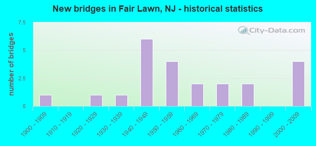
- New bridges - historical statistics
- 11900-1909
- 11920-1929
- 11930-1939
- 61940-1949
- 41950-1959
- 21960-1969
- 21970-1979
- 21980-1989
- 42000-2009

- Reconstructed bridges - Historical Statistics
- 21960-1969
- 01970-1979
- 01980-1989
- 11990-1999
- 12000-2009


- Bridge Condition - Deck
- 22.2%Good
- 44.4%Satisfactory
- 22.2%Fair
- 11.1%Poor

- Bridge Condition - Superstructure
- 16.7%Very good
- 33.3%Good
- 33.3%Satisfactory
- 16.7%Fair

- Bridge Condition - Substructure
- 41.7%Good
- 50.0%Satisfactory
- 8.3%Fair

- Bridge Condition - Channel
- 42.9%Good
- 42.9%Satisfactory
- 14.3%Fair
Find on map >> Show street view
Structure Number: 20017A, Location: 500 FEET SOUTH OF ROUTE 4 (Lat: 40.924689, Lng: -74.090339), Route carried "on" structure: City street , Year Built: 1922, Status: Open, Structure Length: 2.38m (7.81ft), Average Daily Traffic: 18,111 (year 2020), Truck Traffic: 4%, Average Future Daily Traffic: 22,099 (year 2040), Features Intersected: SADDLE RIVER, Facility Carried by Structure: RED MILL ROAD
Minimum Vertical Clearance: 30+ m (98+ ft), Kilometerpoint: 0.064, Lanes on structure: 3, Owner: County Highway Agency, Approaching Roadway Width: 10.7m (35.1ft), Material/Design: Concrete, Design/Construction: Arch - Deck, Number Of Spans In Main Unit: 1, Length of Maximum Span: 21.3m (69.9ft), Curb or Sidewalk Widths: Left: 0.6m (2.0ft), Right: 2.1m (6.9ft), Curb-To-Curb Width: 10.6m (34.8ft), Out-to-Out Width: 14.2m (46.6ft)
Condition: Superstructure: Satisfactory, Substructure: Fair, Channel: Satisfactory, Inventory Rating: 86.2 metric tons, Method Used To Determine Inventory Rating: Allowable Stress (AS), Structural Evaluation: Somewhat better than minimum adequacy, Deck Geometry: High priority of replacement, Waterway Adequacy: Equal to present minimum criteria, Approach Roadway Alignment: Better than present minimum criteria, Length Of Structure Improvement: 2.38m (7.81ft), Designated Inspection Frequency: Every 24 months, Inspection Date: April 2020, Bridge Improvement Cost: $255,000, Roadway Improvement Cost: $65,000, Total Project Cost: $531,000 ( Estimate for 2020), Wearing Surface/Protective System: Wearing Surface: Bituminous
Find on map >> Show street view
Structure Number: 20017B, Location: .26 MI E OF CR 69 (Lat: 40.949311, Lng: -74.141619), Route carried "on" structure: County highway 127II, Year Built: 1976, Status: Open, Structure Length: 1.04m (3.41ft), Average Daily Traffic: 12,405 (year 2020), Truck Traffic: 4%, Average Future Daily Traffic: 15,136 (year 2040), Design Load: H 20, Features Intersected: DIAMOND BROOK, Facility Carried by Structure: HARRISON RD CR127
Minimum Vertical Clearance: 30+ m (98+ ft), Kilometerpoint: 0.322, Lanes on structure: 2, Owner: County Highway Agency, Approaching Roadway Width: 12.2m (40.0ft), Skew: 1 degrees, Material/Design: Prestressed concrete, Design/Construction: Slab, Number Of Spans In Main Unit: 1, Length of Maximum Span: 9.8m (32.2ft), Curb or Sidewalk Widths: Left: 2.4m (7.9ft), Right: 2.4m (7.9ft), Curb-To-Curb Width: 12.3m (40.4ft), Out-to-Out Width: 17.6m (57.7ft)
Condition: Deck: Satisfactory, Superstructure: Satisfactory, Substructure: Good, Channel: Fair, Operating Rating: 36.3 metric tons, Method Used To Determine Operating Rating: Load Factor (LF), Inventory Rating: 21.8 metric tons, Method Used To Determine Inventory Rating: Load Factor (LF), Structural Evaluation: Somewhat better than minimum adequacy, Deck Geometry: Somewhat better than minimum adequacy, Waterway Adequacy: Superior to present desirable criteria, Approach Roadway Alignment: Better than present minimum criteria, Designated Inspection Frequency: Every 24 months, Inspection Date: May 2020, Deck Structure Type: Concrete Precast Panels, Wearing Surface/Protective System: Wearing Surface: Bituminous
Find on map >> Show street view
Structure Number: 20017D, Location: .08 MI W OF PARAMUS RD (Lat: 40.941500, Lng: -74.094369), Route carried "on" structure: County highway 76, Year Built: 1970, Status: Open, Structure Length: 4.11m (13.48ft), Average Daily Traffic: 12,512 (year 2020), Truck Traffic: 4%, Average Future Daily Traffic: 15,267 (year 2040), Design Load: HS 20+Mod, Features Intersected: SADDLE RIVER
Minimum Vertical Clearance: 30+ m (98+ ft), Kilometerpoint: 4.265, Lanes on structure: 4, Owner: County Highway Agency, Approaching Roadway Width: 14.0m (45.9ft), Skew: 2 degrees, Material/Design: Steel, Design/Construction: Stringer/Multi-beam, Number Of Spans In Main Unit: 3, Length of Maximum Span: 13.1m (43.0ft), Curb or Sidewalk Widths: Left: 1.8m (5.9ft), Right: 1.8m (5.9ft), Curb-To-Curb Width: 14.0m (45.9ft), Out-to-Out Width: 18.2m (59.7ft)
Condition: Deck: Satisfactory, Superstructure: Good, Substructure: Satisfactory, Channel: Satisfactory, Operating Rating: 73.5 metric tons, Method Used To Determine Operating Rating: Load Factor (LF), Inventory Rating: 43.5 metric tons, Method Used To Determine Inventory Rating: Load Factor (LF), Structural Evaluation: Equal to present minimum criteria, Deck Geometry: High priority of replacement, Waterway Adequacy: Equal to present desirable criteria, Approach Roadway Alignment: Equal to present minimum criteria, Length Of Structure Improvement: 4.11m (13.48ft), Designated Inspection Frequency: Every 24 months, Inspection Date: April 2020, Bridge Improvement Cost: $88,000, Roadway Improvement Cost: $42,000, Total Project Cost: $119,000 ( Estimate for 2020), Deck Structure Type: Concrete Cast-file-Place, Wearing Surface/Protective System: Wearing Surface: Monolithic Concrete
Find on map >> Show street view
Structure Number: 20017E, Location: 0.57 MI W. OF CR 507 (Lat: 40.923800, Lng: -74.140581), Route carried "on" structure: County highway 78, Year Built: 1904, Year Reconstructed: 2008, Status: Open, Structure Length: 8.02m (26.31ft), Average Daily Traffic: 5,853 (year 2020), Truck Traffic: 4%, Average Future Daily Traffic: 7,142 (year 2040), Design Load: HS 20+Mod, Features Intersected: PASSAIC RIVER
Minimum Vertical Clearance: 30+ m (98+ ft), Kilometerpoint: 0.000, Lanes on structure: 2, Owner: County Highway Agency, Approaching Roadway Width: 11.0m (36.1ft), Material/Design: Steel, Design/Construction: Truss - Thru, Number Of Spans In Main Unit: 3, Length of Maximum Span: 25.9m (85.0ft), Curb or Sidewalk Widths: Left: 0.0m, Right: 1.8m (5.9ft), Curb-To-Curb Width: 8.2m (26.9ft), Out-to-Out Width: 8.7m (28.5ft)
Condition: Deck: Good, Superstructure: Very good, Substructure: Good, Channel: Good, Operating Rating: 57.2 metric tons, Method Used To Determine Operating Rating: Load Factor (LF), Inventory Rating: 34.5 metric tons, Method Used To Determine Inventory Rating: Load Factor (LF), Structural Evaluation: Better than present minimum criteria, Deck Geometry: High priority of corrective action, Waterway Adequacy: Superior to present desirable criteria, Approach Roadway Alignment: Meets minimum limits, Designated Inspection Frequency: Every 24 months, Critical Feature Inspection Frequency: Every 24 months, Underwater Inspection Frequency: Every 48 months, Inspection Date: April 2020, Critical Feature Inspection Date: April 2020, Underwater Inspection Date: May 2020, Deck Structure Type: Concrete Cast-file-Place, Wearing Surface/Protective System: Wearing Surface: Monolithic Concrete, Deck Protection: Epoxy Coated Reinforcing
Find on map >> Show street view
Structure Number: 20017I, Location: 363 FT S OF MAPLE AVE (Lat: 40.940100, Lng: -74.142239), Route carried "on" structure: County highway 507, Year Built: 1984, Status: Open, Structure Length: 0.73m (2.40ft), Average Daily Traffic: 18,660 (year 2020), Truck Traffic: 4%, Average Future Daily Traffic: 20,400 (year 2040), Design Load: HS 20, Features Intersected: Henderson Brook, Facility Carried by Structure: River Road
Minimum Vertical Clearance: 30+ m (98+ ft), Kilometerpoint: 25.540, Lanes on structure: 2, Base Highway Network: Yes, Owner: County Highway Agency, Approaching Roadway Width: 12.3m (40.4ft), Skew: 2 degrees, Material/Design: Concrete, Design/Construction: Culvert, Number Of Spans In Main Unit: 2, Length of Maximum Span: 3.0m (9.8ft), Curb or Sidewalk Widths: Left: 2.2m (7.2ft), Right: 2.4m (7.9ft), Curb-To-Curb Width: 12.3m (40.4ft), Out-to-Out Width: 19.6m (64.3ft)
Condition: Channel: Satisfactory, Culverts: Satisfactory, Operating Rating: 34.5 metric tons, Method Used To Determine Operating Rating: Field evaluation and documented engineering judgment, Inventory Rating: 20.0 metric tons, Method Used To Determine Inventory Rating: Field evaluation and documented engineering judgment, Structural Evaluation: Somewhat better than minimum adequacy, Deck Geometry: Somewhat better than minimum adequacy, Waterway Adequacy: Equal to present desirable criteria, Approach Roadway Alignment: Equal to present desirable criteria, Designated Inspection Frequency: Every 24 months, Inspection Date: May 2020
Find on map >> Show street view
Structure Number: 20017J, Location: 70 FT W OF PARKVIEW PL (Lat: 40.941569, Lng: -74.111689), Route carried "on" structure: County highway 76, Year Built: 1984, Status: Open, Structure Length: 0.70m (2.30ft), Average Daily Traffic: 19,260 (year 2020), Truck Traffic: 4%, Average Future Daily Traffic: 23,110 (year 2040), Design Load: HS 20, Features Intersected: Jordan Brook, Facility Carried by Structure: Fair Lawn Avenue
Minimum Vertical Clearance: 30+ m (98+ ft), Kilometerpoint: 2.527, Lanes on structure: 2, Owner: County Highway Agency, Approaching Roadway Width: 12.2m (40.0ft), Skew: 3 degrees, Material/Design: Concrete, Design/Construction: Culvert, Number Of Spans In Main Unit: 1, Length of Maximum Span: 6.1m (20.0ft), Curb or Sidewalk Widths: Left: 2.7m (8.9ft), Right: 2.8m (9.2ft)
Condition: Channel: Good, Culverts: Satisfactory, Operating Rating: 54.4 metric tons, Method Used To Determine Operating Rating: Field evaluation and documented engineering judgment, Inventory Rating: 32.7 metric tons, Method Used To Determine Inventory Rating: Field evaluation and documented engineering judgment, Structural Evaluation: Equal to present minimum criteria, Waterway Adequacy: Equal to present desirable criteria, Approach Roadway Alignment: Equal to present desirable criteria, Designated Inspection Frequency: Every 24 months, Inspection Date: May 2020
Find on map >> Show street view
Structure Number: 205152, Location: 1.3 MI WEST OF NJ 17 (Lat: 40.926661, Lng: -74.095611), Route carried "on" structure: State highway 4, Year Built: 2002, Status: Open, Structure Length: 7.86m (25.79ft), Average Daily Traffic: 117,756 (year 2020), Truck Traffic: 5%, Average Future Daily Traffic: 143,662 (year 2040), Design Load: HS 20+Mod, Features Intersected: NJ 208 SB & RAMPS
Minimum Vertical Clearance: 30.45m (99.90ft), Kilometerpoint: 3.331, Lanes on structure: 4, Lanes under structure: 4, Base Highway Network: Yes, Owner: State Highway Agency, Approaching Roadway Width: 24.1m (79.1ft), Skew: 35 degrees, Material/Design: Steel continuous, Design/Construction: Stringer/Multi-beam, Number Of Spans In Main Unit: 2, Length of Maximum Span: 42.7m (140.1ft), Curb or Sidewalk Widths: Left: 1.8m (5.9ft), Right: 0.0m, Curb-To-Curb Width: 24.2m (79.4ft), Out-to-Out Width: 27.7m (90.9ft)
Condition: Deck: Good, Superstructure: Very good, Substructure: Good, Inventory Rating: 73.5 metric tons, Method Used To Determine Inventory Rating: Load Factor (LF), Structural Evaluation: Better than present minimum criteria, Deck Geometry: Superior to present desirable criteria, Underclear: High priority of corrective action, Approach Roadway Alignment: Better than present minimum criteria, Length Of Structure Improvement: 7.86m (25.79ft), Designated Inspection Frequency: Every 24 months, Inspection Date: March 2020, Deck Structure Type: Concrete Cast-file-Place, Wearing Surface/Protective System: Wearing Surface: Monolithic Concrete, Deck Protection: Epoxy Coated Reinforcing
Find on map >> Show street view
Structure Number: 206151, Location: 0.62 MI WEST OF GSP (Lat: 40.925950, Lng: -74.091400), Route carried "on" structure: State highway 4, Year Built: 1931, Year Reconstructed: 2001, Status: Open, Structure Length: 2.13m (6.99ft), Average Daily Traffic: 117,756 (year 2020), Truck Traffic: 5%, Average Future Daily Traffic: 143,662 (year 2040), Features Intersected: SADDLE RIVER
Minimum Vertical Clearance: 30.45m (99.90ft), Kilometerpoint: 3.685, Lanes on structure: 10, Base Highway Network: Yes, Owner: State Highway Agency, Approaching Roadway Width: 36.0m (118.1ft), Skew: 30 degrees, Material/Design: Concrete, Design/Construction: Arch - Deck, Number Of Spans In Main Unit: 1, Length of Maximum Span: 21.3m (69.9ft), Curb-To-Curb Width: 36.1m (118.4ft), Out-to-Out Width: 39.0m (128.0ft)
Condition: Superstructure: Satisfactory, Substructure: Good, Channel: Good, Operating Rating: 78.9 metric tons, Method Used To Determine Operating Rating: Load Factor (LF), Inventory Rating: 47.2 metric tons, Method Used To Determine Inventory Rating: Load Factor (LF), Structural Evaluation: Equal to present minimum criteria, Deck Geometry: High priority of replacement, Waterway Adequacy: Superior to present desirable criteria, Approach Roadway Alignment: Equal to present desirable criteria, Length Of Structure Improvement: 2.13m (6.99ft), Designated Inspection Frequency: Every 24 months, Inspection Date: April 2020
Find on map >> Show street view
Structure Number: 23215, Location: 0.1 MI NW OF 208-4 JCT (Lat: 40.927439, Lng: -74.094669), Route carried "on" structure: State highway 208, Year Built: 1952, Status: Open, Structure Length: 1.10m (3.61ft), Average Daily Traffic: 70,090 (year 2021), Truck Traffic: 5%, Average Future Daily Traffic: 83,790 (year 2041), Design Load: HS 20+Mod, Features Intersected: SADDLE RIVER ROAD
Minimum Vertical Clearance: 30+ m (98+ ft), Kilometerpoint: 0.177, Lanes on structure: 2, Lanes under structure: 1, Base Highway Network: Yes, Owner: State Highway Agency, Approaching Roadway Width: 13.7m (44.9ft), Material/Design: Steel, Design/Construction: Stringer/Multi-beam, Number Of Spans In Main Unit: 1, Length of Maximum Span: 10.1m (33.1ft), Curb or Sidewalk Widths: Left: 0.9m (3.0ft), Right: 0.0m, Curb-To-Curb Width: 12.8m (42.0ft), Out-to-Out Width: 14.6m (47.9ft)
Condition: Deck: Satisfactory, Superstructure: Good, Substructure: Satisfactory, Operating Rating: 66.2 metric tons, Method Used To Determine Operating Rating: Load Factor (LF), Inventory Rating: 39.0 metric tons, Method Used To Determine Inventory Rating: Load Factor (LF), Structural Evaluation: Equal to present minimum criteria, Deck Geometry: Equal to present desirable criteria, Underclear: Somewhat better than minimum adequacy, Approach Roadway Alignment: Equal to present desirable criteria, Designated Inspection Frequency: Every 24 months, Inspection Date: June 2021, Deck Structure Type: Concrete Cast-file-Place, Wearing Surface/Protective System: Wearing Surface: Latex Concrete, Deck Protection: Epoxy Coated Reinforcing
Find on map >> Show street view
Structure Number: 232152, Location: .9MI W OF 208-4 JCT (Lat: 40.931631, Lng: -74.111650), Route carried "on" structure: County highway , Year Built: 1962, Status: Open, Structure Length: 8.17m (26.80ft), Average Daily Traffic: 7,916 (year 2021), Truck Traffic: 4%, Average Future Daily Traffic: 9,659 (year 2041), Design Load: HS 20, Features Intersected: NJ ROUTE 208, Facility Carried by Structure: MORLOT AVE (CR 78)
Minimum Vertical Clearance: 30+ m (98+ ft), Kilometerpoint: 2.591, Lanes on structure: 2, Lanes under structure: 5, Owner: State Highway Agency, Approaching Roadway Width: 11.6m (38.1ft), Skew: 5 degrees, Material/Design: Steel, Design/Construction: Stringer/Multi-beam, Number Of Spans In Main Unit: 4, Length of Maximum Span: 30.2m (99.1ft), Curb or Sidewalk Widths: Left: 1.8m (5.9ft), Right: 1.8m (5.9ft), Curb-To-Curb Width: 11.6m (38.1ft), Out-to-Out Width: 16.0m (52.5ft)
Condition: Deck: Satisfactory, Superstructure: Fair, Substructure: Satisfactory, Operating Rating: 76.2 metric tons, Method Used To Determine Operating Rating: Load Factor (LF), Inventory Rating: 45.4 metric tons, Method Used To Determine Inventory Rating: Load Factor (LF), Structural Evaluation: Somewhat better than minimum adequacy, Deck Geometry: Somewhat better than minimum adequacy, Underclear: High priority of corrective action, Approach Roadway Alignment: Equal to present minimum criteria, Length Of Structure Improvement: 8.20m (26.90ft), Designated Inspection Frequency: Every 24 months, Inspection Date: June 2021, Bridge Improvement Cost: $560,000, Roadway Improvement Cost: $717,000, Total Project Cost: $825,000 ( Estimate for 2021), Deck Structure Type: Concrete Cast-file-Place, Wearing Surface/Protective System: Wearing Surface: Latex Concrete
Find on map >> Show street view
Structure Number: 232153, Location: 1.2 Mi. N of NJ 4 Junc. (Lat: 40.933181, Lng: -74.115969), Route carried "on" structure: State highway 208, Year Built: 1949, Year Reconstructed: 1967, Status: Open, Structure Length: 2.99m (9.81ft), Average Daily Traffic: 65,620 (year 2020), Truck Traffic: 5%, Average Future Daily Traffic: 80,070 (year 2040), Design Load: HS 20+Mod, Features Intersected: Plaza Road
Minimum Vertical Clearance: 30+ m (98+ ft), Kilometerpoint: 1.963, Lanes on structure: 6, Lanes under structure: 2, Base Highway Network: Yes, Owner: State Highway Agency, Approaching Roadway Width: 25.9m (85.0ft), Skew: 34 degrees, Material/Design: Steel, Design/Construction: Stringer/Multi-beam, Number Of Spans In Main Unit: 1, Length of Maximum Span: 27.1m (88.9ft), Curb or Sidewalk Widths: Left: 1.8m (5.9ft), Right: 1.8m (5.9ft), Curb-To-Curb Width: 25.9m (85.0ft), Out-to-Out Width: 30.9m (101.4ft)
Condition: Deck: Fair, Superstructure: Good, Substructure: Satisfactory, Operating Rating: 60.8 metric tons, Method Used To Determine Operating Rating: Load Factor (LF), Inventory Rating: 36.3 metric tons, Method Used To Determine Inventory Rating: Load Factor (LF), Structural Evaluation: Equal to present minimum criteria, Deck Geometry: Meets minimum limits, Underclear: High priority of corrective action, Approach Roadway Alignment: Equal to present desirable criteria, Length Of Structure Improvement: 2.99m (9.81ft), Designated Inspection Frequency: Every 24 months, Inspection Date: March 2020, Roadway Improvement Cost: $230,000, Total Project Cost: $276,000 ( Estimate for 2020), Deck Structure Type: Concrete Cast-file-Place, Wearing Surface/Protective System: Wearing Surface: Latex Concrete
Find on map >> Show street view
Structure Number: 232154, Location: 1.4 Mi. N. OF NJ 4 Junc. (Lat: 40.934050, Lng: -74.119400), Route carried "on" structure: State highway 208, Year Built: 1948, Year Reconstructed: 1967, Status: Open, Structure Length: 5.24m (17.19ft), Average Daily Traffic: 65,620 (year 2020), Truck Traffic: 5%, Average Future Daily Traffic: 80,056 (year 2040), Design Load: HS 20+Mod, Features Intersected: NJ TRANSIT,20TH STREET
Minimum Vertical Clearance: 30+ m (98+ ft), Kilometerpoint: 2.285, Lanes on structure: 6, Lanes under structure: 2, Base Highway Network: Yes, Owner: State Highway Agency, Approaching Roadway Width: 27.4m (89.9ft), Skew: 33 degrees, Material/Design: Steel, Design/Construction: Stringer/Multi-beam, Number Of Spans In Main Unit: 2, Length of Maximum Span: 25.3m (83.0ft), Curb or Sidewalk Widths: Left: 1.8m (5.9ft), Right: 2.3m (7.5ft), Curb-To-Curb Width: 27.4m (89.9ft), Out-to-Out Width: 33.0m (108.3ft)
Condition: Deck: Fair, Superstructure: Good, Substructure: Satisfactory, Operating Rating: 63.5 metric tons, Method Used To Determine Operating Rating: Load Factor (LF), Inventory Rating: 38.1 metric tons, Method Used To Determine Inventory Rating: Load Factor (LF), Structural Evaluation: Equal to present minimum criteria, Deck Geometry: Equal to present minimum criteria, Underclear: Somewhat better than minimum adequacy, Approach Roadway Alignment: Better than present minimum criteria, Designated Inspection Frequency: Every 24 months, Inspection Date: March 2020, Deck Structure Type: Concrete Cast-file-Place, Wearing Surface/Protective System: Wearing Surface: Latex Concrete
Find on map >> Show street view
Structure Number: 232155, Location: 1.8 Mi N. of NJ 4 Junc. (Lat: 40.937731, Lng: -74.125750), Route carried "on" structure: County highway 76, Year Built: 1949, Status: Open, Structure Length: 3.08m (10.10ft), Average Daily Traffic: 18,950 (year 2020), Truck Traffic: 4%, Average Future Daily Traffic: 23,130 (year 2040), Design Load: HS 20, Features Intersected: NJ 208
Minimum Vertical Clearance: 30+ m (98+ ft), Kilometerpoint: 1.255, Lanes on structure: 4, Lanes under structure: 6, Owner: State Highway Agency, Approaching Roadway Width: 13.4m (44.0ft), Material/Design: Concrete, Design/Construction: Frame, Number Of Spans In Main Unit: 1, Length of Maximum Span: 27.1m (88.9ft), Curb or Sidewalk Widths: Left: 1.1m (3.6ft), Right: 1.1m (3.6ft), Curb-To-Curb Width: 13.4m (44.0ft), Out-to-Out Width: 17.8m (58.4ft)
Condition: Superstructure: Satisfactory, Substructure: Good, Operating Rating: 66.2 metric tons, Method Used To Determine Operating Rating: Load Factor (LF), Inventory Rating: 39.0 metric tons, Method Used To Determine Inventory Rating: Load Factor (LF), Structural Evaluation: Equal to present minimum criteria, Deck Geometry: High priority of replacement, Underclear: High priority of replacement, Approach Roadway Alignment: Better than present minimum criteria, Length Of Structure Improvement: 3.90m (12.80ft), Designated Inspection Frequency: Every 24 months, Inspection Date: April 2020, Bridge Improvement Cost: $3,316,000, Roadway Improvement Cost: $470,000, Total Project Cost: $5,506,000 ( Estimate for 2020)
Find on map >> Show street view
Structure Number: 232157, Location: 2.9MI W OF 208-4 JCT (Lat: 40.950181, Lng: -74.137361), Route carried "on" structure: County highway 507, Year Built: 1955, Status: Open, Structure Length: 3.44m (11.29ft), Average Daily Traffic: 16,187 (year 2020), Truck Traffic: 4%, Average Future Daily Traffic: 19,751 (year 2040), Design Load: HS 20, Features Intersected: NJ ROUTE 208
Minimum Vertical Clearance: 30+ m (98+ ft), Kilometerpoint: 26.860, Lanes on structure: 2, Lanes under structure: 6, Base Highway Network: Yes, Owner: State Highway Agency, Approaching Roadway Width: 12.5m (41.0ft), Skew: 2 degrees, Material/Design: Steel, Design/Construction: Stringer/Multi-beam, Number Of Spans In Main Unit: 2, Length of Maximum Span: 16.5m (54.1ft), Curb or Sidewalk Widths: Left: 1.8m (5.9ft), Right: 1.8m (5.9ft), Curb-To-Curb Width: 12.2m (40.0ft), Out-to-Out Width: 16.4m (53.8ft)
Condition: Deck: Poor, Superstructure: Fair, Substructure: Satisfactory, Operating Rating: 81.6 metric tons, Method Used To Determine Operating Rating: Load Factor (LF), Inventory Rating: 49.0 metric tons, Method Used To Determine Inventory Rating: Load Factor (LF), Structural Evaluation: Somewhat better than minimum adequacy, Deck Geometry: Somewhat better than minimum adequacy, Underclear: High priority of corrective action, Approach Roadway Alignment: Equal to present desirable criteria, Length Of Structure Improvement: 3.44m (11.29ft), Designated Inspection Frequency: Every 24 months, Inspection Date: April 2020, Bridge Improvement Cost: $2,496,000, Roadway Improvement Cost: $225,000, Total Project Cost: $3,485,000 ( Estimate for 2020), Deck Structure Type: Concrete Cast-file-Place, Wearing Surface/Protective System: Wearing Surface: Bituminous
Find on map >> Show street view
Structure Number: 205152, Location: 1.3 MI WEST OF NJ 17 (Lat: 40.926661, Lng: -74.095611), Route carried "under" structure: Ramp State highway 208, Year Built: 2002, Structure Length: 0. m, Average Daily Traffic: 6,192 (year 2020), Truck Traffic: 5%, Features Intersected: NJ 208 SB & RAMPS, Facility Carried by Structure: NJ 4
Minimum Vertical Clearance: 5.00m (16.40ft), Kilometerpoint: 0.145, Lanes on structure: 4, Lanes under structure: 1, Material/Design: Steel continuous, Design/Construction: Stringer/Multi-beam, Length of Maximum Span: 42.7m (140.1ft)
Find on map >> Show street view
Structure Number: 205152, Location: 1.3 MI WEST OF NJ 17 (Lat: 40.926661, Lng: -74.095611), Route carried "under" structure: Ramp State highway 208, Year Built: 2002, Structure Length: 0. m, Average Daily Traffic: 5,856 (year 2020), Truck Traffic: 5%, Features Intersected: NJ 208 SB & RAMPS, Facility Carried by Structure: NJ 4
Minimum Vertical Clearance: 5.28m (17.32ft), Kilometerpoint: 0.145, Lanes on structure: 4, Lanes under structure: 1, Material/Design: Steel continuous, Design/Construction: Stringer/Multi-beam, Length of Maximum Span: 42.7m (140.1ft)
Find on map >> Show street view
Structure Number: 205152, Location: 1.3 MI WEST OF NJ 17 (Lat: 40.926661, Lng: -74.095611), Route carried "under" structure: State highway 208, Year Built: 2002, Structure Length: 0. m, Average Daily Traffic: 66,699 (year 2020), Truck Traffic: 5%, Features Intersected: NJ 208 SB & RAMPS, Facility Carried by Structure: NJ 4
Minimum Vertical Clearance: 4.82m (15.81ft), Kilometerpoint: 0.145, Lanes on structure: 4, Lanes under structure: 2, Material/Design: Steel continuous, Design/Construction: Stringer/Multi-beam, Length of Maximum Span: 42.7m (140.1ft)
Find on map >> Show street view
Structure Number: 23215, Location: 0.1 MI NW OF 208-4 JCT (Lat: 40.927439, Lng: -74.094669), Route carried "under" structure: County highway , Year Built: 1952, Structure Length: 0. m, Average Daily Traffic: 1,540 (year 2021), Truck Traffic: 3%, Features Intersected: SADDLE RIVER ROAD, Facility Carried by Structure: NJ 208 NB
Minimum Vertical Clearance: 4.85m (15.91ft), Kilometerpoint: 4.023, Lanes on structure: 2, Lanes under structure: 1, Material/Design: Steel, Design/Construction: Stringer/Multi-beam, Length of Maximum Span: 10.1m (33.1ft)
Find on map >> Show street view
Structure Number: 232152, Location: .9MI W OF 208-4 JCT (Lat: 40.931631, Lng: -74.111650), Route carried "under" structure: State highway 208, Year Built: 1962, Structure Length: 0. m, Average Daily Traffic: 66,306 (year 2021), Truck Traffic: 5%, Features Intersected: NJ ROUTE 208, Facility Carried by Structure: MORLOT AVE (CR 78)
Minimum Vertical Clearance: 4.67m (15.32ft), Kilometerpoint: 1.513, Lanes on structure: 2, Lanes under structure: 5, Material/Design: Steel, Design/Construction: Stringer/Multi-beam, Length of Maximum Span: 30.2m (99.1ft)
Find on map >> Show street view
Structure Number: 232153, Location: 1.2 Mi. N of NJ 4 Junc. (Lat: 40.933181, Lng: -74.115969), Route carried "under" structure: City street , Year Built: 1949, Structure Length: 0. m, Average Daily Traffic: 17,795 (year 2020), Truck Traffic: 3%, Features Intersected: Plaza Road, Facility Carried by Structure: NJ 208
Minimum Vertical Clearance: 4.52m (14.83ft), Kilometerpoint: 1.207, Lanes on structure: 6, Lanes under structure: 2, Material/Design: Steel, Design/Construction: Stringer/Multi-beam, Length of Maximum Span: 27.1m (88.9ft)
Find on map >> Show street view
Structure Number: 232154, Location: 1.4 Mi. N. OF NJ 4 Junc. (Lat: 40.934050, Lng: -74.119400), Route carried "under" structure: City street , Year Built: 1948, Structure Length: 0. m, Average Daily Traffic: 1,335 (year 2020), Truck Traffic: 3%, Features Intersected: NJ TRANSIT,20TH STREET, Facility Carried by Structure: NJ 208
Minimum Vertical Clearance: 6.93m (22.74ft), Kilometerpoint: 0.000, Lanes on structure: 6, Lanes under structure: 2, Material/Design: Steel, Design/Construction: Stringer/Multi-beam, Length of Maximum Span: 25.3m (83.0ft)
Find on map >> Show street view
Structure Number: 232155, Location: 1.8 Mi N. of NJ 4 Junc. (Lat: 40.937731, Lng: -74.125750), Route carried "under" structure: State highway 208, Year Built: 1949, Structure Length: 0. m, Average Daily Traffic: 68,850 (year 2020), Truck Traffic: 5%, Features Intersected: NJ 208, Facility Carried by Structure: FAIR LAWN AV(CR76)
Minimum Vertical Clearance: 5.21m (17.09ft), Kilometerpoint: 2.945, Lanes on structure: 4, Lanes under structure: 6, Material/Design: Concrete, Design/Construction: Frame, Length of Maximum Span: 27.1m (88.9ft)
Find on map >> Show street view
Structure Number: 232157, Location: 2.9MI W OF 208-4 JCT (Lat: 40.950181, Lng: -74.137361), Route carried "under" structure: State highway 208, Year Built: 1955, Structure Length: 0. m, Average Daily Traffic: 80,375 (year 2020), Truck Traffic: 5%, Features Intersected: NJ ROUTE 208, Facility Carried by Structure: MAPLE AVE (CR 507)
Minimum Vertical Clearance: 4.44m (14.57ft), Kilometerpoint: 4.635, Lanes on structure: 2, Lanes under structure: 6, Material/Design: Steel, Design/Construction: Stringer/Multi-beam, Length of Maximum Span: 16.5m (54.1ft)