Bridge Statistics for Exeter, New Hampshire (NH)
Condition, Traffic, Stress, Structural Evaluation, Project Costs
- National Bridge Inventory (NBI) Statistics
- 36Number of bridges
- 404ft / 123mTotal length
- $91,118,000Total costs
- 471,083Total average daily traffic
- 21,480Total average daily truck traffic
- National Bridge Inventory (NBI) Registered Bridges for Exeter
- No street view available for this location
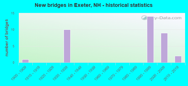
- New bridges - historical statistics
- 11900-1909
- 101930-1939
- 141990-1999
- 92000-2009
- 22010-2019

- Reconstructed bridges - Historical Statistics
- 31970-1979
- 11980-1989
- 21990-1999
- 12000-2009
- 12010-2019


- Bridge Condition - Deck
- 3.4%Excellent
- 34.5%Very good
- 48.3%Good
- 3.4%Satisfactory
- 6.9%Fair
- 3.4%Poor

- Bridge Condition - Superstructure
- 6.9%Excellent
- 34.5%Very good
- 37.9%Good
- 10.3%Satisfactory
- 10.3%Fair

- Bridge Condition - Substructure
- 3.4%Excellent
- 41.4%Very good
- 31.0%Good
- 6.9%Satisfactory
- 13.8%Fair
- 3.4%Poor

- Bridge Condition - Channel
- 21.1%Excellent
- 21.1%Very good
- 47.4%Good
- 5.3%Satisfactory
- 5.3%Fair
Find on map >> Show street view
Structure Number: 82004000111, Location: EXETER (Lat: 43.008497, Lng: -71.002456), Route carried "on" structure: State highway 101, Year Built: 2000, Status: Open, Structure Length: 4.63m (15.19ft), Average Daily Traffic: 41,170 (year 2020), Truck Traffic: 3%, Average Future Daily Traffic: 60,931 (year 2042), Design Load: HS 25 or greater, Features Intersected: LITTLE RIVER
Minimum Vertical Clearance: 30+ m (98+ ft), Kilometerpoint: 132.669, Lanes on structure: 4, Base Highway Network: Yes, Owner: State Highway Agency, Approaching Roadway Width: 15.8m (51.8ft), Skew: 30 degrees, Material/Design: Steel, Design/Construction: Stringer/Multi-beam, Number Of Spans In Main Unit: 1, Length of Maximum Span: 45.1m (148.0ft), Curb or Sidewalk Widths: Left: 0.1m (0.3ft), Right: 0.1m (0.3ft), Curb-To-Curb Width: 15.8m (51.8ft), Out-to-Out Width: 31.9m (104.7ft)
Condition: Deck: Very good, Superstructure: Good, Substructure: Very good, Channel: Excellent, Operating Rating: 82.6 metric tons, Method Used To Determine Operating Rating: Load Factor (LF), Inventory Rating: 49.9 metric tons, Method Used To Determine Inventory Rating: Load Factor (LF), Structural Evaluation: Better than present minimum criteria, Deck Geometry: High priority of replacement, Waterway Adequacy: Superior to present desirable criteria, Approach Roadway Alignment: Superior to present desirable criteria, Length Of Structure Improvement: 4.63m (15.19ft), Designated Inspection Frequency: Every 24 months, Inspection Date: May 2020, Bridge Improvement Cost: $2,718,000, Roadway Improvement Cost: $200,000, Total Project Cost: $3,142,000 ( Estimate for 2022), Deck Structure Type: Concrete Cast-file-Place, Wearing Surface/Protective System: Wearing Surface: Bituminous, Membrane: Other, Deck Protection: Epoxy Coated Reinforcing
Find on map >> Show street view
Structure Number: 82004400057, Location: AT BRENTWOOD TL (Lat: 42.969853, Lng: -71.000611), Route carried "on" structure: Other road , Year Built: 1930, Year Reconstructed: 2008, Status: Open, Structure Length: 1.62m (5.31ft), Average Daily Traffic: 910 (year 2020), Truck Traffic: 4%, Average Future Daily Traffic: 1,346 (year 2042), Features Intersected: EXETER RIVER, Facility Carried by Structure: CROSS ROAD
Minimum Vertical Clearance: 30+ m (98+ ft), Kilometerpoint: 0.953, Lanes on structure: 2, Owner: City or Municipal Highway Agency, Approaching Roadway Width: 4.9m (16.1ft), Material/Design: Steel, Design/Construction: Stringer/Multi-beam, Number Of Spans In Main Unit: 1, Length of Maximum Span: 14.9m (48.9ft), Curb-To-Curb Width: 5.2m (17.1ft), Out-to-Out Width: 5.5m (18.0ft)
Condition: Deck: Good, Superstructure: Satisfactory, Substructure: Fair, Channel: Good, Operating Rating: 52.3 metric tons, Method Used To Determine Operating Rating: Allowable Stress (AS), Inventory Rating: 39.2 metric tons, Method Used To Determine Inventory Rating: Allowable Stress (AS), Structural Evaluation: Somewhat better than minimum adequacy, Deck Geometry: High priority of replacement, Waterway Adequacy: Better than present minimum criteria, Approach Roadway Alignment: Equal to present minimum criteria, Length Of Structure Improvement: 1.62m (5.31ft), Designated Inspection Frequency: Every 24 months, Inspection Date: August 2020, Bridge Improvement Cost: $2,718,000, Roadway Improvement Cost: $200,000, Total Project Cost: $3,142,000 ( Estimate for 2022), Deck Structure Type: Wood or Timber, Wearing Surface/Protective System: Wearing Surface: Bituminous
Find on map >> Show street view
Structure Number: 82004500085, Location: .6 MI. FROM BRENTWOOD TL (Lat: 42.988731, Lng: -71.000358), Route carried "on" structure: State highway 111A, Year Built: 1936, Year Reconstructed: 1979, Status: Open, Structure Length: 0.79m (2.59ft), Average Daily Traffic: 1,556 (year 2020), Truck Traffic: 4%, Average Future Daily Traffic: 2,302 (year 2042), Design Load: H 15, Features Intersected: DUDLEY BROOK
Minimum Vertical Clearance: 30+ m (98+ ft), Kilometerpoint: 342.871, Lanes on structure: 2, Owner: State Highway Agency, Approaching Roadway Width: 6.1m (20.0ft), Material/Design: Concrete, Design/Construction: Slab, Number Of Spans In Main Unit: 1, Length of Maximum Span: 7.3m (24.0ft), Curb-To-Curb Width: 9.8m (32.2ft), Out-to-Out Width: 11.0m (36.1ft)
Condition: Deck: Satisfactory, Superstructure: Satisfactory, Substructure: Fair, Channel: Satisfactory, Operating Rating: 42.6 metric tons, Method Used To Determine Operating Rating: Load Factor (LF), Inventory Rating: 25.5 metric tons, Method Used To Determine Inventory Rating: Load Factor (LF), Structural Evaluation: Somewhat better than minimum adequacy, Deck Geometry: Somewhat better than minimum adequacy, Waterway Adequacy: Equal to present desirable criteria, Approach Roadway Alignment: Equal to present desirable criteria, Length Of Structure Improvement: 0.79m (2.59ft), Designated Inspection Frequency: Every 24 months, Inspection Date: May 2020, Bridge Improvement Cost: $2,718,000, Roadway Improvement Cost: $200,000, Total Project Cost: $3,142,000 ( Estimate for 2022), Deck Structure Type: Concrete Cast-file-Place, Wearing Surface/Protective System: Wearing Surface: Bituminous
Find on map >> Show street view
Structure Number: 82005700052, Location: 0.6 MI FROM BRENTWOOD TL (Lat: 42.965092, Lng: -70.988272), Route carried "on" structure: State highway 111, Year Built: 1933, Year Reconstructed: 1986, Status: Open, Structure Length: 1.16m (3.81ft), Average Daily Traffic: 4,376 (year 2020), Truck Traffic: 4%, Average Future Daily Traffic: 6,476 (year 2042), Design Load: HS 20, Features Intersected: EXETER RIVER
Minimum Vertical Clearance: 30+ m (98+ ft), Kilometerpoint: 61.026, Lanes on structure: 2, Owner: State Highway Agency, Approaching Roadway Width: 7.0m (23.0ft), Material/Design: Steel, Design/Construction: Stringer/Multi-beam, Number Of Spans In Main Unit: 1, Length of Maximum Span: 9.4m (30.8ft), Curb or Sidewalk Widths: Left: 0.2m (0.7ft), Right: 0.2m (0.7ft), Curb-To-Curb Width: 9.9m (32.5ft), Out-to-Out Width: 11.0m (36.1ft)
Condition: Deck: Very good, Superstructure: Good, Substructure: Good, Channel: Very good, Operating Rating: 67.1 metric tons, Method Used To Determine Operating Rating: Load and Resistance Factor (LRFR), Inventory Rating: 39.9 metric tons, Method Used To Determine Inventory Rating: Load and Resistance Factor (LRFR), Structural Evaluation: Better than present minimum criteria, Deck Geometry: Meets minimum limits, Waterway Adequacy: Equal to present desirable criteria, Approach Roadway Alignment: Equal to present desirable criteria, Length Of Structure Improvement: 1.16m (3.81ft), Designated Inspection Frequency: Every 24 months, Inspection Date: May 2020, Bridge Improvement Cost: $2,718,000, Roadway Improvement Cost: $200,000, Total Project Cost: $3,142,000 ( Estimate for 2022), Deck Structure Type: Concrete Cast-file-Place, Wearing Surface/Protective System: Wearing Surface: Bituminous, Membrane: Other
Find on map >> Show street view
Structure Number: 82005800106, Location: 0.6MI W NH 27 OVERPASS (Lat: 43.005969, Lng: -70.987031), Route carried "on" structure: State highway 101, Year Built: 2000, Status: Open, Structure Length: 0.73m (2.40ft), Average Daily Traffic: 20,566 (year 2020), Truck Traffic: 3%, Average Future Daily Traffic: 30,437 (year 2042), Design Load: HS 25 or greater, Features Intersected: CONNOR FARM ROAD
Minimum Vertical Clearance: 30+ m (98+ ft), Kilometerpoint: 133.971, Lanes on structure: 2, Lanes under structure: 1, Base Highway Network: Yes, Owner: State Highway Agency, Approaching Roadway Width: 12.5m (41.0ft), Material/Design: Concrete, Design/Construction: Slab, Number Of Spans In Main Unit: 1, Length of Maximum Span: 6.7m (22.0ft), Curb or Sidewalk Widths: Left: 0.1m (0.3ft), Right: 0.1m (0.3ft), Curb-To-Curb Width: 12.5m (41.0ft), Out-to-Out Width: 13.6m (44.6ft)
Condition: Deck: Very good, Superstructure: Very good, Substructure: Good, Operating Rating: 89.8 metric tons, Method Used To Determine Operating Rating: Load Factor (LF), Inventory Rating: 54.4 metric tons, Method Used To Determine Inventory Rating: Load Factor (LF), Structural Evaluation: Better than present minimum criteria, Deck Geometry: Better than present minimum criteria, Underclear: High priority of replacement, Approach Roadway Alignment: Superior to present desirable criteria, Length Of Structure Improvement: 0.73m (2.40ft), Designated Inspection Frequency: Every 24 months, Inspection Date: May 2020, Bridge Improvement Cost: $2,718,000, Roadway Improvement Cost: $200,000, Total Project Cost: $3,142,000 ( Estimate for 2022), Deck Structure Type: Concrete Cast-file-Place, Wearing Surface/Protective System: Wearing Surface: Bituminous, Membrane: Other, Deck Protection: Epoxy Coated Reinforcing
Find on map >> Show street view
Structure Number: 82005800107, Location: 0.6MI W NH 27 OVERPASS (Lat: 43.006153, Lng: -70.986875), Route carried "on" structure: State highway 101, Year Built: 2000, Status: Open, Structure Length: 0.73m (2.40ft), Average Daily Traffic: 20,604 (year 2020), Truck Traffic: 3%, Average Future Daily Traffic: 30,493 (year 2042), Design Load: HS 25 or greater, Features Intersected: CONNOR FARM ROAD
Minimum Vertical Clearance: 30+ m (98+ ft), Kilometerpoint: 46.314, Lanes on structure: 2, Lanes under structure: 1, Base Highway Network: Yes, Owner: State Highway Agency, Approaching Roadway Width: 12.5m (41.0ft), Material/Design: Concrete, Design/Construction: Slab, Number Of Spans In Main Unit: 1, Length of Maximum Span: 6.7m (22.0ft), Curb or Sidewalk Widths: Left: 0.1m (0.3ft), Right: 0.1m (0.3ft), Curb-To-Curb Width: 12.5m (41.0ft), Out-to-Out Width: 13.6m (44.6ft)
Condition: Deck: Very good, Superstructure: Very good, Substructure: Very good, Operating Rating: 89.8 metric tons, Method Used To Determine Operating Rating: Load Factor (LF), Inventory Rating: 54.4 metric tons, Method Used To Determine Inventory Rating: Load Factor (LF), Structural Evaluation: Equal to present desirable criteria, Deck Geometry: Better than present minimum criteria, Underclear: High priority of replacement, Approach Roadway Alignment: Superior to present desirable criteria, Length Of Structure Improvement: 0.73m (2.40ft), Designated Inspection Frequency: Every 24 months, Inspection Date: May 2020, Bridge Improvement Cost: $2,718,000, Roadway Improvement Cost: $200,000, Total Project Cost: $3,142,000 ( Estimate for 2022), Deck Structure Type: Concrete Cast-file-Place, Wearing Surface/Protective System: Wearing Surface: Bituminous, Membrane: Other, Deck Protection: Epoxy Coated Reinforcing
Find on map >> Show street view
Structure Number: 82006200102, Location: 0.3MI W NH 27 OVERPASS (Lat: 43.003503, Lng: -70.982094), Route carried "on" structure: State highway 101, Year Built: 1998, Status: Open, Structure Length: 2.84m (9.32ft), Average Daily Traffic: 20,566 (year 2020), Truck Traffic: 3%, Average Future Daily Traffic: 30,437 (year 2042), Design Load: HS 25 or greater, Features Intersected: BLOODY BROOK
Minimum Vertical Clearance: 30+ m (98+ ft), Kilometerpoint: 134.456, Lanes on structure: 2, Base Highway Network: Yes, Owner: State Highway Agency, Approaching Roadway Width: 17.4m (57.1ft), Material/Design: Prestressed concrete, Design/Construction: Stringer/Multi-beam, Number Of Spans In Main Unit: 1, Length of Maximum Span: 26.5m (86.9ft), Curb-To-Curb Width: 17.1m (56.1ft), Out-to-Out Width: 17.5m (57.4ft)
Condition: Deck: Good, Superstructure: Good, Substructure: Very good, Channel: Excellent, Operating Rating: 78.9 metric tons, Method Used To Determine Operating Rating: Load Factor (LF), Inventory Rating: 47.2 metric tons, Method Used To Determine Inventory Rating: Load Factor (LF), Structural Evaluation: Better than present minimum criteria, Deck Geometry: Superior to present desirable criteria, Waterway Adequacy: Superior to present desirable criteria, Approach Roadway Alignment: Better than present minimum criteria, Length Of Structure Improvement: 2.84m (9.32ft), Designated Inspection Frequency: Every 24 months, Inspection Date: May 2020, Bridge Improvement Cost: $2,718,000, Roadway Improvement Cost: $200,000, Total Project Cost: $3,142,000 ( Estimate for 2022), Deck Structure Type: Concrete Cast-file-Place, Wearing Surface/Protective System: Wearing Surface: Integral Concrete, Deck Protection: Epoxy Coated Reinforcing
Find on map >> Show street view
Structure Number: 82006200103, Location: 0.3MI W NH 27 OVERPASS (Lat: 43.003767, Lng: -70.981947), Route carried "on" structure: State highway 101, Year Built: 1998, Status: Open, Structure Length: 2.76m (9.06ft), Average Daily Traffic: 22,939 (year 2020), Truck Traffic: 3%, Average Future Daily Traffic: 33,949 (year 2042), Design Load: HS 25 or greater, Features Intersected: BLOODY BROOK
Minimum Vertical Clearance: 30+ m (98+ ft), Kilometerpoint: 45.831, Lanes on structure: 3, Base Highway Network: Yes, Owner: State Highway Agency, Approaching Roadway Width: 19.8m (65.0ft), Material/Design: Prestressed concrete, Design/Construction: Stringer/Multi-beam, Number Of Spans In Main Unit: 1, Length of Maximum Span: 26.5m (86.9ft), Curb-To-Curb Width: 20.8m (68.2ft), Out-to-Out Width: 21.6m (70.9ft)
Condition: Deck: Good, Superstructure: Very good, Substructure: Very good, Channel: Excellent, Operating Rating: 82.6 metric tons, Method Used To Determine Operating Rating: Load Factor (LF), Inventory Rating: 49.0 metric tons, Method Used To Determine Inventory Rating: Load Factor (LF), Structural Evaluation: Equal to present desirable criteria, Deck Geometry: Superior to present desirable criteria, Waterway Adequacy: Superior to present desirable criteria, Approach Roadway Alignment: Superior to present desirable criteria, Length Of Structure Improvement: 2.76m (9.06ft), Designated Inspection Frequency: Every 24 months, Inspection Date: May 2020, Bridge Improvement Cost: $2,718,000, Roadway Improvement Cost: $200,000, Total Project Cost: $3,142,000 ( Estimate for 2022), Deck Structure Type: Concrete Cast-file-Place, Wearing Surface/Protective System: Wearing Surface: Integral Concrete, Deck Protection: Epoxy Coated Reinforcing
Find on map >> Show street view
Structure Number: 82006300105, Location: 0.6 MI W JCT NH 27/NH101 (Lat: 43.004106, Lng: -70.981133), Route carried "on" structure: State highway 27, Year Built: 1998, Status: Open, Structure Length: 3.02m (9.91ft), Average Daily Traffic: 11,080 (year 2020), Average Future Daily Traffic: 16,398 (year 2042), Design Load: HS 25 or greater, Features Intersected: BLOODY BROOK
Minimum Vertical Clearance: 30+ m (98+ ft), Kilometerpoint: 41.893, Lanes on structure: 2, Owner: State Highway Agency, Approaching Roadway Width: 21.0m (68.9ft), Skew: 2 degrees, Material/Design: Prestressed concrete, Design/Construction: Stringer/Multi-beam, Number Of Spans In Main Unit: 1, Length of Maximum Span: 28.6m (93.8ft), Curb or Sidewalk Widths: Left: 0.1m (0.3ft), Right: 1.5m (4.9ft), Curb-To-Curb Width: 20.8m (68.2ft), Out-to-Out Width: 21.8m (71.5ft)
Condition: Deck: Good, Superstructure: Very good, Substructure: Very good, Channel: Very good, Operating Rating: 89.8 metric tons, Method Used To Determine Operating Rating: Load Factor (LF), Inventory Rating: 51.7 metric tons, Method Used To Determine Inventory Rating: Load Factor (LF), Structural Evaluation: Equal to present desirable criteria, Deck Geometry: Superior to present desirable criteria, Waterway Adequacy: Equal to present desirable criteria, Approach Roadway Alignment: Equal to present desirable criteria, Length Of Structure Improvement: 3.02m (9.91ft), Designated Inspection Frequency: Every 24 months, Inspection Date: May 2020, Bridge Improvement Cost: $2,718,000, Roadway Improvement Cost: $200,000, Total Project Cost: $3,142,000 ( Estimate for 2022), Deck Structure Type: Concrete Cast-file-Place, Wearing Surface/Protective System: Wearing Surface: Bituminous, Membrane: Preformed Fabric, Deck Protection: Epoxy Coated Reinforcing
Find on map >> Show street view
Structure Number: 82006800083, Location: 0.6MI RTE 111A (Lat: 42.987683, Lng: -70.977939), Route carried "on" structure: Other road , Year Built: 1930, Year Reconstructed: 1976, Status: Open, Structure Length: 0.82m (2.69ft), Average Daily Traffic: 12 (year 2020), Truck Traffic: 4%, Average Future Daily Traffic: 17 (year 2042), Features Intersected: LITTLE RIVER, Facility Carried by Structure: GARRISON LANE
Minimum Vertical Clearance: 30+ m (98+ ft), Kilometerpoint: 0.246, Lanes on structure: 2, Owner: City or Municipal Highway Agency, Approaching Roadway Width: 5.2m (17.1ft), Material/Design: Steel, Design/Construction: Stringer/Multi-beam, Number Of Spans In Main Unit: 1, Length of Maximum Span: 7.6m (24.9ft), Curb-To-Curb Width: 4.9m (16.1ft), Out-to-Out Width: 5.5m (18.0ft)
Condition: Deck: Poor, Superstructure: Satisfactory, Substructure: Poor, Channel: Good, Operating Rating: 48.4 metric tons, Method Used To Determine Operating Rating: Allowable Stress (AS), Inventory Rating: 36.3 metric tons, Method Used To Determine Inventory Rating: Allowable Stress (AS), Structural Evaluation: Meets minimum limits, Deck Geometry: High priority of corrective action, Waterway Adequacy: Better than present minimum criteria, Approach Roadway Alignment: Better than present minimum criteria, Length Of Structure Improvement: 0.82m (2.69ft), Designated Inspection Frequency: Every 16 months, Inspection Date: November 2021, Bridge Improvement Cost: $2,718,000, Roadway Improvement Cost: $200,000, Total Project Cost: $3,142,000 ( Estimate for 2022), Deck Structure Type: Wood or Timber, Wearing Surface/Protective System: Wearing Surface: Wood or Timber
Find on map >> Show street view
Structure Number: 82006800102, Location: JCT NH 27/NH101 (Lat: 43.001619, Lng: -70.976167), Route carried "on" structure: State highway 27, Year Built: 1999, Status: Open, Structure Length: 6.67m (21.88ft), Average Daily Traffic: 11,080 (year 2020), Truck Traffic: 4%, Average Future Daily Traffic: 16,398 (year 2042), Design Load: HS 25 or greater, Features Intersected: NH101
Minimum Vertical Clearance: 30+ m (98+ ft), Kilometerpoint: 42.413, Lanes on structure: 4, Lanes under structure: 4, Owner: State Highway Agency, Approaching Roadway Width: 21.9m (71.9ft), Skew: 24 degrees, Material/Design: Steel continuous, Design/Construction: Stringer/Multi-beam, Number Of Spans In Main Unit: 2, Length of Maximum Span: 32.6m (107.0ft), Curb or Sidewalk Widths: Left: 0.1m (0.3ft), Right: 1.5m (4.9ft), Curb-To-Curb Width: 21.9m (71.9ft), Out-to-Out Width: 24.8m (81.4ft)
Condition: Deck: Very good, Superstructure: Good, Substructure: Very good, Operating Rating: 75.4 metric tons, Method Used To Determine Operating Rating: Load Factor (LF), Inventory Rating: 45.7 metric tons, Method Used To Determine Inventory Rating: Load Factor (LF), Structural Evaluation: Better than present minimum criteria, Deck Geometry: Superior to present desirable criteria, Underclear: Equal to present minimum criteria, Approach Roadway Alignment: Equal to present desirable criteria, Length Of Structure Improvement: 6.67m (21.88ft), Designated Inspection Frequency: Every 24 months, Inspection Date: May 2020, Bridge Improvement Cost: $2,718,000, Roadway Improvement Cost: $200,000, Total Project Cost: $3,142,000 ( Estimate for 2022), Deck Structure Type: Concrete Cast-file-Place, Wearing Surface/Protective System: Wearing Surface: Bituminous, Membrane: Other, Deck Protection: Epoxy Coated Reinforcing
Find on map >> Show street view
Structure Number: 82007500078, Location: 1.75 MI. TO BRENTWOOD TL (Lat: 42.984253, Lng: -70.971742), Route carried "on" structure: State highway 111A, Year Built: 1934, Status: Open, Structure Length: 0.98m (3.22ft), Average Daily Traffic: 2,475 (year 2020), Truck Traffic: 5%, Average Future Daily Traffic: 3,663 (year 2042), Features Intersected: LITTLE RIVER
Minimum Vertical Clearance: 30+ m (98+ ft), Kilometerpoint: 345.346, Lanes on structure: 2, Owner: State Highway Agency, Approaching Roadway Width: 6.7m (22.0ft), Skew: 2 degrees, Material/Design: Concrete, Design/Construction: Tee Beam, Number Of Spans In Main Unit: 1, Length of Maximum Span: 9.1m (29.9ft), Curb or Sidewalk Widths: Left: 0.1m (0.3ft), Right: 0.1m (0.3ft), Curb-To-Curb Width: 6.9m (22.6ft), Out-to-Out Width: 7.3m (24.0ft)
Condition: Deck: Good, Superstructure: Fair, Substructure: Fair, Channel: Good, Operating Rating: 42.6 metric tons, Method Used To Determine Operating Rating: Load Factor (LF), Inventory Rating: 25.4 metric tons, Method Used To Determine Inventory Rating: Load Factor (LF), Structural Evaluation: Somewhat better than minimum adequacy, Deck Geometry: High priority of replacement, Waterway Adequacy: Equal to present desirable criteria, Approach Roadway Alignment: Equal to present desirable criteria, Length Of Structure Improvement: 0.98m (3.22ft), Designated Inspection Frequency: Every 24 months, Underwater Inspection Frequency: Every 60 months, Inspection Date: May 2020, Underwater Inspection Date: July 2019, Bridge Improvement Cost: $2,718,000, Roadway Improvement Cost: $200,000, Total Project Cost: $3,142,000 ( Estimate for 2022), Deck Structure Type: Concrete Cast-file-Place, Wearing Surface/Protective System: Wearing Surface: Bituminous
Find on map >> Show street view
Structure Number: 8200780007, Location: 1.4 MI FROM JCT 101C (Lat: 42.977608, Lng: -70.969047), Route carried "on" structure: State highway 111, Year Built: 1930, Year Reconstructed: 1981, Status: Open, Structure Length: 0.82m (2.69ft), Average Daily Traffic: 5,970 (year 2020), Truck Traffic: 5%, Average Future Daily Traffic: 8,835 (year 2042), Features Intersected: LITTLE RIVER
Minimum Vertical Clearance: 30+ m (98+ ft), Kilometerpoint: 63.201, Lanes on structure: 2, Owner: State Highway Agency, Approaching Roadway Width: 6.7m (22.0ft), Skew: 3 degrees, Material/Design: Concrete, Design/Construction: Frame, Number Of Spans In Main Unit: 1, Length of Maximum Span: 7.3m (24.0ft), Curb or Sidewalk Widths: Left: 0.2m (0.7ft), Right: 1.1m (3.6ft), Curb-To-Curb Width: 9.8m (32.2ft), Out-to-Out Width: 11.8m (38.7ft)
Condition: Deck: Good, Superstructure: Good, Substructure: Good, Channel: Good, Operating Rating: 41.5 metric tons, Method Used To Determine Operating Rating: Load Factor (LF), Inventory Rating: 24.9 metric tons, Method Used To Determine Inventory Rating: Load Factor (LF), Structural Evaluation: Equal to present minimum criteria, Deck Geometry: Meets minimum limits, Waterway Adequacy: Equal to present desirable criteria, Approach Roadway Alignment: Equal to present desirable criteria, Length Of Structure Improvement: 0.82m (2.69ft), Designated Inspection Frequency: Every 24 months, Inspection Date: May 2020, Bridge Improvement Cost: $2,718,000, Roadway Improvement Cost: $200,000, Total Project Cost: $3,142,000 ( Estimate for 2022), Deck Structure Type: Concrete Cast-file-Place, Wearing Surface/Protective System: Wearing Surface: Bituminous
Find on map >> Show street view
Structure Number: 82008100046, Location: 1.36MI. RTE 111 (Lat: 42.961814, Lng: -70.964847), Route carried "on" structure: Other road , Year Built: 1993, Status: Open, Structure Length: 1.80m (5.91ft), Average Daily Traffic: 455 (year 2020), Truck Traffic: 4%, Average Future Daily Traffic: 673 (year 2042), Features Intersected: EXETER RIVER, Facility Carried by Structure: LINDEN STREET
Minimum Vertical Clearance: 30+ m (98+ ft), Kilometerpoint: 0.843, Lanes on structure: 2, Owner: City or Municipal Highway Agency, Approaching Roadway Width: 7.3m (24.0ft), Material/Design: Wood or Timber, Design/Construction: Stringer/Multi-beam, Number Of Spans In Main Unit: 1, Length of Maximum Span: 16.2m (53.1ft), Curb-To-Curb Width: 7.3m (24.0ft), Out-to-Out Width: 8.0m (26.2ft)
Condition: Deck: Good, Superstructure: Very good, Substructure: Satisfactory, Channel: Good, Operating Rating: 56.0 metric tons, Method Used To Determine Operating Rating: Allowable Stress (AS), Inventory Rating: 41.8 metric tons, Method Used To Determine Inventory Rating: Allowable Stress (AS), Structural Evaluation: Equal to present minimum criteria, Deck Geometry: Meets minimum limits, Waterway Adequacy: Better than present minimum criteria, Approach Roadway Alignment: Better than present minimum criteria, Length Of Structure Improvement: 1.80m (5.91ft), Designated Inspection Frequency: Every 24 months, Inspection Date: August 2020, Bridge Improvement Cost: $2,718,000, Roadway Improvement Cost: $200,000, Total Project Cost: $3,142,000 ( Estimate for 2022), Deck Structure Type: Wood or Timber, Wearing Surface/Protective System: Wearing Surface: Bituminous
Find on map >> Show street view
Structure Number: 82008700062, Location: 0.39MI. RTE 111 (Lat: 42.972136, Lng: -70.959594), Route carried "on" structure: Other road , Year Built: 2015, Status: Open, Structure Length: 1.55m (5.09ft), Average Daily Traffic: 2,767 (year 2020), Truck Traffic: 4%, Average Future Daily Traffic: 4,095 (year 2042), Design Load: HL 93, Features Intersected: LITTLE RIVER, Facility Carried by Structure: LINDEN STREET
Minimum Vertical Clearance: 30+ m (98+ ft), Kilometerpoint: 2.260, Lanes on structure: 2, Owner: City or Municipal Highway Agency, Approaching Roadway Width: 7.3m (24.0ft), Material/Design: Prestressed concrete, Design/Construction: Box Beam or Girders - Multiple, Number Of Spans In Main Unit: 1, Length of Maximum Span: 14.3m (46.9ft), Curb or Sidewalk Widths: Left: 0.2m (0.7ft), Right: 1.7m (5.6ft), Curb-To-Curb Width: 7.9m (25.9ft), Out-to-Out Width: 10.7m (35.1ft)
Condition: Deck: Very good, Superstructure: Excellent, Substructure: Very good, Channel: Very good, Operating Rating: 64.1 metric tons, Method Used To Determine Operating Rating: Load and Resistance Factor (LRFR), Inventory Rating: 49.6 metric tons, Method Used To Determine Inventory Rating: Load and Resistance Factor (LRFR), Structural Evaluation: Equal to present desirable criteria, Deck Geometry: High priority of corrective action, Waterway Adequacy: Equal to present desirable criteria, Approach Roadway Alignment: Equal to present desirable criteria, Length Of Structure Improvement: 1.55m (5.09ft), Designated Inspection Frequency: Every 24 months, Inspection Date: August 2020, Bridge Improvement Cost: $2,718,000, Roadway Improvement Cost: $200,000, Total Project Cost: $3,142,000 ( Estimate for 2022), Deck Structure Type: Concrete Cast-file-Place, Wearing Surface/Protective System: Wearing Surface: Bituminous, Membrane: Preformed Fabric, Deck Protection: Epoxy Coated Reinforcing
Find on map >> Show street view
Structure Number: 82008800076, Location: 0.22MI RTE 111A (Lat: 42.984389, Lng: -70.955978), Route carried "on" structure: City street , Year Built: 1900, Year Reconstructed: 2004, Status: Posted for load, Structure Length: 1.92m (6.30ft), Average Daily Traffic: 761 (year 2020), Truck Traffic: 4%, Average Future Daily Traffic: 1,126 (year 2042), Features Intersected: PAR, Facility Carried by Structure: PARK STREET
Minimum Vertical Clearance: 30+ m (98+ ft), Kilometerpoint: 0.415, Lanes on structure: 1, Owner: State Highway Agency, Approaching Roadway Width: 5.2m (17.1ft), Skew: 4 degrees, Material/Design: Steel, Number Of Spans In Main Unit: 1, Length of Maximum Span: 17.7m (58.1ft), Curb or Sidewalk Widths: Left: 0.0m, Right: 1.2m (3.9ft), Curb-To-Curb Width: 5.3m (17.4ft), Out-to-Out Width: 8.1m (26.6ft)
Condition: Deck: Fair, Superstructure: Fair, Substructure: Good, Operating Rating: 11.2 metric tons, Method Used To Determine Operating Rating: Load Factor (LF), Inventory Rating: 8.2 metric tons, Method Used To Determine Inventory Rating: Load Factor (LF), Structural Evaluation: High priority of replacement, Deck Geometry: High priority of replacement, Underclear: High priority of replacement, Approach Roadway Alignment: Equal to present minimum criteria, Bridge Posting: Required (Relationship of Operating Rating to Maximum Legal Load: > 39.9% below), Length Of Structure Improvement: 1.92m (6.30ft), Designated Inspection Frequency: Every 24 months, Critical Feature Inspection Frequency: Every 24 months, Inspection Date: November 2020, Critical Feature Inspection Date: November 2020, Bridge Improvement Cost: $2,718,000, Roadway Improvement Cost: $200,000, Total Project Cost: $3,142,000 ( Estimate for 2022), Deck Structure Type: Wood or Timber, Wearing Surface/Protective System: Wearing Surface: Wood or Timber
Find on map >> Show street view
Structure Number: 82008900045, Location: 0.3 MI FROM KENSINGTON TL (Lat: 42.961503, Lng: -70.956219), Route carried "on" structure: State highway 108, Year Built: 1935, Status: Open, Structure Length: 3.72m (12.20ft), Average Daily Traffic: 4,948 (year 2020), Truck Traffic: 4%, Average Future Daily Traffic: 7,323 (year 2042), Design Load: H 15, Features Intersected: EXETER RIVER
Minimum Vertical Clearance: 30+ m (98+ ft), Kilometerpoint: 22.249, Lanes on structure: 2, Owner: State Highway Agency, Approaching Roadway Width: 7.3m (24.0ft), Skew: 3 degrees, Material/Design: Concrete continuous, Design/Construction: Tee Beam, Number Of Spans In Main Unit: 3, Length of Maximum Span: 14.6m (47.9ft), Curb or Sidewalk Widths: Left: 0.2m (0.7ft), Right: 0.2m (0.7ft), Curb-To-Curb Width: 7.3m (24.0ft), Out-to-Out Width: 8.6m (28.2ft)
Condition: Deck: Fair, Superstructure: Fair, Substructure: Fair, Channel: Fair, Operating Rating: 42.6 metric tons, Method Used To Determine Operating Rating: Load Factor (LF), Inventory Rating: 25.4 metric tons, Method Used To Determine Inventory Rating: Load Factor (LF), Structural Evaluation: Somewhat better than minimum adequacy, Deck Geometry: High priority of replacement, Waterway Adequacy: Equal to present desirable criteria, Approach Roadway Alignment: Equal to present desirable criteria, Length Of Structure Improvement: 3.72m (12.20ft), Designated Inspection Frequency: Every 24 months, Underwater Inspection Frequency: Every 60 months, Inspection Date: June 2020, Underwater Inspection Date: June 2020, Bridge Improvement Cost: $2,718,000, Roadway Improvement Cost: $200,000, Total Project Cost: $3,142,000 ( Estimate for 2022), Deck Structure Type: Concrete Cast-file-Place, Wearing Surface/Protective System: Wearing Surface: Bituminous
Find on map >> Show street view
Structure Number: 82009500063, Location: .6 MI FROM JCT 101C (Lat: 42.972567, Lng: -70.950961), Route carried "on" structure: State highway 108, Year Built: 2018, Status: Open, Structure Length: 1.83m (6.00ft), Average Daily Traffic: 4,577 (year 2020), Truck Traffic: 5%, Average Future Daily Traffic: 6,773 (year 2042), Design Load: HL 93, Features Intersected: LITTLE RIVER
Minimum Vertical Clearance: 30+ m (98+ ft), Kilometerpoint: 23.558, Lanes on structure: 2, Owner: City or Municipal Highway Agency, Approaching Roadway Width: 10.5m (34.4ft), Material/Design: Prestressed concrete, Design/Construction: Box Beam or Girders - Multiple, Number Of Spans In Main Unit: 1, Length of Maximum Span: 17.4m (57.1ft), Curb or Sidewalk Widths: Left: 0.2m (0.7ft), Right: 1.7m (5.6ft), Curb-To-Curb Width: 10.2m (33.5ft), Out-to-Out Width: 13.0m (42.7ft)
Condition: Deck: Excellent, Superstructure: Excellent, Substructure: Excellent, Channel: Very good, Operating Rating: 70.2 metric tons, Method Used To Determine Operating Rating: Load and Resistance Factor (LRFR), Inventory Rating: 54.4 metric tons, Method Used To Determine Inventory Rating: Load and Resistance Factor (LRFR), Structural Evaluation: Superior to present desirable criteria, Deck Geometry: Meets minimum limits, Waterway Adequacy: Equal to present minimum criteria, Approach Roadway Alignment: Equal to present desirable criteria, Length Of Structure Improvement: 1.83m (6.00ft), Designated Inspection Frequency: Every 24 months, Inspection Date: August 2020, Bridge Improvement Cost: $2,718,000, Roadway Improvement Cost: $200,000, Total Project Cost: $3,142,000 ( Estimate for 2022), Deck Structure Type: Concrete Cast-file-Place, Wearing Surface/Protective System: Wearing Surface: Bituminous, Membrane: Preformed Fabric, Deck Protection: Epoxy Coated Reinforcing
Find on map >> Show street view
Structure Number: 820098001, Location: 1.5 MI NEWFIELDS TL (Lat: 43.001375, Lng: -70.947100), Route carried "on" structure: State highway 85, Year Built: 1994, Status: Open, Structure Length: 5.36m (17.59ft), Average Daily Traffic: 6,009 (year 2020), Truck Traffic: 10%, Average Future Daily Traffic: 8,893 (year 2042), Design Load: HS 25 or greater, Features Intersected: NH101
Minimum Vertical Clearance: 30+ m (98+ ft), Kilometerpoint: 2.401, Lanes on structure: 4, Lanes under structure: 4, Owner: State Highway Agency, Approaching Roadway Width: 16.5m (54.1ft), Skew: 22 degrees, Material/Design: Steel continuous, Design/Construction: Stringer/Multi-beam, Number Of Spans In Main Unit: 2, Length of Maximum Span: 25.9m (85.0ft), Curb or Sidewalk Widths: Left: 2.1m (6.9ft), Right: 2.1m (6.9ft), Curb-To-Curb Width: 16.5m (54.1ft), Out-to-Out Width: 23.3m (76.4ft)
Condition: Deck: Good, Superstructure: Good, Substructure: Good, Operating Rating: 75.3 metric tons, Method Used To Determine Operating Rating: Load Factor (LF), Inventory Rating: 45.1 metric tons, Method Used To Determine Inventory Rating: Load Factor (LF), Structural Evaluation: Better than present minimum criteria, Deck Geometry: Meets minimum limits, Underclear: Equal to present minimum criteria, Approach Roadway Alignment: Equal to present desirable criteria, Length Of Structure Improvement: 5.36m (17.59ft), Designated Inspection Frequency: Every 24 months, Inspection Date: May 2020, Bridge Improvement Cost: $2,718,000, Roadway Improvement Cost: $200,000, Total Project Cost: $3,142,000 ( Estimate for 2022), Deck Structure Type: Concrete Cast-file-Place, Wearing Surface/Protective System: Wearing Surface: Bituminous, Membrane: Preformed Fabric, Deck Protection: Epoxy Coated Reinforcing
Find on map >> Show street view
Structure Number: 82010200074, Location: 120FT RTE 108 (Lat: 42.981744, Lng: -70.945697), Route carried "on" structure: City street , Year Built: 1935, Status: Open, Structure Length: 1.77m (5.81ft), Average Daily Traffic: 1,521 (year 2020), Truck Traffic: 4%, Average Future Daily Traffic: 2,251 (year 2042), Design Load: H 10, Features Intersected: SQUAMSCOTT RIVER, Facility Carried by Structure: STRING BRIDGE ST
Minimum Vertical Clearance: 30+ m (98+ ft), Kilometerpoint: 0.055, Lanes on structure: 2, Owner: City or Municipal Highway Agency, Approaching Roadway Width: 7.3m (24.0ft), Material/Design: Concrete, Design/Construction: Frame, Number Of Spans In Main Unit: 1, Length of Maximum Span: 15.2m (49.9ft), Curb or Sidewalk Widths: Left: 1.5m (4.9ft), Right: 0.3m (1.0ft), Curb-To-Curb Width: 6.4m (21.0ft), Out-to-Out Width: 9.0m (29.5ft)
Condition: Deck: Good, Superstructure: Good, Substructure: Good, Channel: Good, Operating Rating: 41.8 metric tons, Method Used To Determine Operating Rating: Load Factor (LF), Inventory Rating: 24.9 metric tons, Method Used To Determine Inventory Rating: Load Factor (LF), Structural Evaluation: Equal to present minimum criteria, Deck Geometry: High priority of replacement, Waterway Adequacy: Equal to present desirable criteria, Approach Roadway Alignment: Better than present minimum criteria, Length Of Structure Improvement: 1.77m (5.81ft), Designated Inspection Frequency: Every 24 months, Inspection Date: August 2020, Bridge Improvement Cost: $2,718,000, Roadway Improvement Cost: $200,000, Total Project Cost: $3,142,000 ( Estimate for 2022), Deck Structure Type: Concrete Cast-file-Place, Wearing Surface/Protective System: Wearing Surface: Bituminous
Find on map >> Show street view
Structure Number: 820102001, Location: 0.2 MI E JCT NH 85 (Lat: 43.000614, Lng: -70.943872), Route carried "on" structure: State highway 101, Year Built: 1998, Status: Open, Structure Length: 2.90m (9.51ft), Average Daily Traffic: 24,288 (year 2020), Truck Traffic: 8%, Average Future Daily Traffic: 35,946 (year 2042), Design Load: HS 25 or greater, Features Intersected: PAR
Minimum Vertical Clearance: 30+ m (98+ ft), Kilometerpoint: 137.689, Lanes on structure: 2, Base Highway Network: Yes, Owner: State Highway Agency, Approaching Roadway Width: 8.2m (26.9ft), Material/Design: Steel, Design/Construction: Stringer/Multi-beam, Number Of Spans In Main Unit: 1, Length of Maximum Span: 27.4m (89.9ft), Curb or Sidewalk Widths: Left: 0.2m (0.7ft), Right: 0.2m (0.7ft), Curb-To-Curb Width: 20.3m (66.6ft), Out-to-Out Width: 22.0m (72.2ft)
Condition: Deck: Very good, Superstructure: Very good, Substructure: Very good, Operating Rating: 81.7 metric tons, Method Used To Determine Operating Rating: Load Factor (LF), Inventory Rating: 49.0 metric tons, Method Used To Determine Inventory Rating: Load Factor (LF), Structural Evaluation: Equal to present desirable criteria, Deck Geometry: Superior to present desirable criteria, Underclear: Somewhat better than minimum adequacy, Approach Roadway Alignment: Equal to present desirable criteria, Length Of Structure Improvement: 2.90m (9.51ft), Designated Inspection Frequency: Every 24 months, Inspection Date: May 2020, Bridge Improvement Cost: $2,718,000, Roadway Improvement Cost: $200,000, Total Project Cost: $3,142,000 ( Estimate for 2022), Deck Structure Type: Concrete Cast-file-Place, Wearing Surface/Protective System: Wearing Surface: Bituminous, Membrane: Other
Find on map >> Show street view
Structure Number: 82010200101, Location: 0.2 MI E JCT NH 85 (Lat: 43.000914, Lng: -70.943753), Route carried "on" structure: State highway 101, Year Built: 1994, Status: Open, Structure Length: 2.90m (9.51ft), Average Daily Traffic: 24,389 (year 2020), Truck Traffic: 7%, Average Future Daily Traffic: 36,095 (year 2042), Design Load: HS 25 or greater, Features Intersected: PAR
Minimum Vertical Clearance: 30+ m (98+ ft), Kilometerpoint: 42.603, Lanes on structure: 2, Base Highway Network: Yes, Owner: State Highway Agency, Approaching Roadway Width: 20.1m (65.9ft), Material/Design: Steel, Design/Construction: Stringer/Multi-beam, Number Of Spans In Main Unit: 1, Length of Maximum Span: 27.4m (89.9ft), Curb or Sidewalk Widths: Left: 0.2m (0.7ft), Right: 0.2m (0.7ft), Curb-To-Curb Width: 24.4m (80.1ft), Out-to-Out Width: 25.5m (83.7ft)
Condition: Deck: Good, Superstructure: Very good, Substructure: Very good, Operating Rating: 80.3 metric tons, Method Used To Determine Operating Rating: Load Factor (LF), Inventory Rating: 48.0 metric tons, Method Used To Determine Inventory Rating: Load Factor (LF), Structural Evaluation: Equal to present desirable criteria, Deck Geometry: Superior to present desirable criteria, Underclear: Somewhat better than minimum adequacy, Approach Roadway Alignment: Equal to present desirable criteria, Length Of Structure Improvement: 2.90m (9.51ft), Designated Inspection Frequency: Every 24 months, Inspection Date: May 2020, Bridge Improvement Cost: $2,718,000, Roadway Improvement Cost: $200,000, Total Project Cost: $3,142,000 ( Estimate for 2022), Deck Structure Type: Concrete Cast-file-Place, Wearing Surface/Protective System: Wearing Surface: Bituminous, Membrane: Preformed Fabric, Deck Protection: Epoxy Coated Reinforcing
Find on map >> Show street view
Structure Number: 82010300073, Location: .1 MI FROM JCT RT 101C (Lat: 42.980842, Lng: -70.943992), Route carried "on" structure: State highway 108, Year Built: 1934, Year Reconstructed: 2002, Status: Open, Structure Length: 1.98m (6.50ft), Average Daily Traffic: 14,767 (year 2020), Truck Traffic: 5%, Average Future Daily Traffic: 21,855 (year 2042), Design Load: HS 25 or greater, Features Intersected: EXETER RIVER
Minimum Vertical Clearance: 30+ m (98+ ft), Kilometerpoint: 46.330, Lanes on structure: 2, Owner: City or Municipal Highway Agency, Approaching Roadway Width: 9.1m (29.9ft), Material/Design: Concrete, Design/Construction: Stringer/Multi-beam, Number Of Spans In Main Unit: 1, Length of Maximum Span: 19.2m (63.0ft), Curb or Sidewalk Widths: Left: 1.5m (4.9ft), Right: 1.5m (4.9ft), Curb-To-Curb Width: 8.8m (28.9ft), Out-to-Out Width: 13.1m (43.0ft)
Condition: Deck: Very good, Superstructure: Very good, Substructure: Satisfactory, Channel: Good, Operating Rating: 67.3 metric tons, Method Used To Determine Operating Rating: Load Factor (LF), Inventory Rating: 40.8 metric tons, Method Used To Determine Inventory Rating: Load Factor (LF), Structural Evaluation: Equal to present minimum criteria, Deck Geometry: High priority of replacement, Waterway Adequacy: Equal to present desirable criteria, Approach Roadway Alignment: Equal to present minimum criteria, Length Of Structure Improvement: 1.98m (6.50ft), Designated Inspection Frequency: Every 24 months, Underwater Inspection Frequency: Every 60 months, Inspection Date: August 2020, Underwater Inspection Date: June 2015, Bridge Improvement Cost: $2,718,000, Roadway Improvement Cost: $200,000, Total Project Cost: $3,142,000 ( Estimate for 2022), Deck Structure Type: Concrete Cast-file-Place, Wearing Surface/Protective System: Wearing Surface: Bituminous, Membrane: Preformed Fabric, Deck Protection: Epoxy Coated Reinforcing
Find on map >> Show street view
Structure Number: 82010300074, Location: 0.05MI RTE 108 (Lat: 42.982072, Lng: -70.945311), Route carried "on" structure: City street , Year Built: 1935, Year Reconstructed: 2018, Status: Open, Structure Length: 1.77m (5.81ft), Average Daily Traffic: 1,521 (year 2020), Truck Traffic: 4%, Average Future Daily Traffic: 2,251 (year 2042), Design Load: H 10, Features Intersected: SQUAMSCOTT RIVER, Facility Carried by Structure: STRING BRIDGE ST
Minimum Vertical Clearance: 30+ m (98+ ft), Kilometerpoint: 0.101, Lanes on structure: 2, Owner: City or Municipal Highway Agency, Approaching Roadway Width: 7.3m (24.0ft), Material/Design: Concrete, Design/Construction: Frame, Number Of Spans In Main Unit: 1, Length of Maximum Span: 15.2m (49.9ft), Curb or Sidewalk Widths: Left: 1.5m (4.9ft), Right: 0.3m (1.0ft), Curb-To-Curb Width: 6.4m (21.0ft), Out-to-Out Width: 9.0m (29.5ft)
Condition: Deck: Good, Superstructure: Good, Substructure: Good, Channel: Good, Operating Rating: 41.8 metric tons, Method Used To Determine Operating Rating: Load Factor (LF), Inventory Rating: 24.9 metric tons, Method Used To Determine Inventory Rating: Load Factor (LF), Structural Evaluation: Equal to present minimum criteria, Deck Geometry: High priority of replacement, Waterway Adequacy: Equal to present desirable criteria, Approach Roadway Alignment: Better than present minimum criteria, Length Of Structure Improvement: 1.77m (5.81ft), Designated Inspection Frequency: Every 24 months, Inspection Date: August 2020, Bridge Improvement Cost: $2,718,000, Roadway Improvement Cost: $200,000, Total Project Cost: $3,142,000 ( Estimate for 2022), Deck Structure Type: Concrete Cast-file-Place, Wearing Surface/Protective System: Wearing Surface: Bituminous
Find on map >> Show street view
Structure Number: 820106001, Location: At Stratham Town Line (Lat: 42.999956, Lng: -70.939847), Route carried "on" structure: State highway 101, Year Built: 1998, Status: Open, Structure Length: 26.82m (87.99ft), Average Daily Traffic: 22,736 (year 2020), Truck Traffic: 5%, Average Future Daily Traffic: 33,649 (year 2042), Design Load: HS 25 or greater, Features Intersected: SQUAMSCOTT RIVER
Minimum Vertical Clearance: 30+ m (98+ ft), Kilometerpoint: 138.095, Lanes on structure: 2, Base Highway Network: Yes, Owner: State Highway Agency, Approaching Roadway Width: 11.0m (36.1ft), Material/Design: Steel continuous, Design/Construction: Stringer/Multi-beam, Number Of Spans In Main Unit: 6, Length of Maximum Span: 47.5m (155.8ft), Curb or Sidewalk Widths: Left: 0.1m (0.3ft), Right: 0.1m (0.3ft), Curb-To-Curb Width: 14.4m (47.2ft), Out-to-Out Width: 15.5m (50.9ft)
Condition: Deck: Good, Superstructure: Good, Substructure: Good, Channel: Excellent, Operating Rating: 81.6 metric tons, Method Used To Determine Operating Rating: Load Factor (LF), Inventory Rating: 49.0 metric tons, Method Used To Determine Inventory Rating: Load Factor (LF), Structural Evaluation: Better than present minimum criteria, Deck Geometry: Superior to present desirable criteria, Waterway Adequacy: Equal to present desirable criteria, Approach Roadway Alignment: Better than present minimum criteria, Length Of Structure Improvement: 26.82m (87.99ft), Designated Inspection Frequency: Every 24 months, Inspection Date: May 2020, Bridge Improvement Cost: $2,718,000, Roadway Improvement Cost: $200,000, Total Project Cost: $3,142,000 ( Estimate for 2022), Deck Structure Type: Concrete Cast-file-Place, Wearing Surface/Protective System: Wearing Surface: Bituminous, Membrane: Preformed Fabric, Deck Protection: Epoxy Coated Reinforcing
Find on map >> Show street view
Structure Number: 820107001, Location: 0.3 MI E JCT NH 85 (Lat: 43.000122, Lng: -70.939808), Route carried "on" structure: State highway 101, Year Built: 1994, Status: Open, Structure Length: 26.82m (87.99ft), Average Daily Traffic: 22,974 (year 2020), Truck Traffic: 7%, Average Future Daily Traffic: 34,001 (year 2042), Design Load: HS 25 or greater, Features Intersected: SQUAMSCOTT RIVER
Minimum Vertical Clearance: 30+ m (98+ ft), Kilometerpoint: 42.197, Lanes on structure: 2, Base Highway Network: Yes, Owner: State Highway Agency, Approaching Roadway Width: 14.3m (46.9ft), Material/Design: Steel continuous, Design/Construction: Stringer/Multi-beam, Number Of Spans In Main Unit: 6, Length of Maximum Span: 47.6m (156.2ft), Curb or Sidewalk Widths: Left: 0.2m (0.7ft), Right: 0.2m (0.7ft), Curb-To-Curb Width: 15.2m (49.9ft), Out-to-Out Width: 16.1m (52.8ft)
Condition: Deck: Good, Superstructure: Good, Substructure: Good, Channel: Good, Operating Rating: 81.6 metric tons, Method Used To Determine Operating Rating: Load Factor (LF), Inventory Rating: 49.0 metric tons, Method Used To Determine Inventory Rating: Load Factor (LF), Structural Evaluation: Better than present minimum criteria, Deck Geometry: Superior to present desirable criteria, Waterway Adequacy: Superior to present desirable criteria, Approach Roadway Alignment: Equal to present desirable criteria, Length Of Structure Improvement: 26.82m (87.99ft), Designated Inspection Frequency: Every 24 months, Inspection Date: May 2020, Bridge Improvement Cost: $2,718,000, Roadway Improvement Cost: $200,000, Total Project Cost: $3,142,000 ( Estimate for 2022), Deck Structure Type: Concrete Cast-file-Place, Wearing Surface/Protective System: Wearing Surface: Bituminous, Membrane: Preformed Fabric, Deck Protection: Epoxy Coated Reinforcing
Find on map >> Show street view
Structure Number: 82013800068, Location: 1.1 MI FROM HAMPTON TL (Lat: 42.977833, Lng: -70.907369), Route carried "on" structure: Other road , Year Built: 1995, Status: Open, Structure Length: 5.12m (16.80ft), Average Daily Traffic: 2,557 (year 2020), Truck Traffic: 4%, Average Future Daily Traffic: 3,784 (year 2042), Design Load: HS 25 or greater, Features Intersected: NH101, Facility Carried by Structure: GUINEA ROAD
Minimum Vertical Clearance: 30+ m (98+ ft), Kilometerpoint: 0.295, Lanes on structure: 2, Lanes under structure: 4, Owner: State Highway Agency, Approaching Roadway Width: 9.4m (30.8ft), Material/Design: Steel continuous, Design/Construction: Stringer/Multi-beam, Number Of Spans In Main Unit: 2, Length of Maximum Span: 24.7m (81.0ft), Curb or Sidewalk Widths: Left: 0.2m (0.7ft), Right: 0.2m (0.7ft), Curb-To-Curb Width: 10.4m (34.1ft), Out-to-Out Width: 11.4m (37.4ft)
Condition: Deck: Good, Superstructure: Very good, Substructure: Very good, Operating Rating: 84.1 metric tons, Method Used To Determine Operating Rating: Load Factor (LF), Inventory Rating: 50.6 metric tons, Method Used To Determine Inventory Rating: Load Factor (LF), Structural Evaluation: Equal to present desirable criteria, Deck Geometry: Somewhat better than minimum adequacy, Underclear: Equal to present minimum criteria, Approach Roadway Alignment: Equal to present desirable criteria, Length Of Structure Improvement: 5.12m (16.80ft), Designated Inspection Frequency: Every 24 months, Inspection Date: May 2020, Bridge Improvement Cost: $2,718,000, Roadway Improvement Cost: $200,000, Total Project Cost: $3,142,000 ( Estimate for 2022), Deck Structure Type: Concrete Cast-file-Place, Wearing Surface/Protective System: Wearing Surface: Bituminous, Membrane: Preformed Fabric, Deck Protection: Epoxy Coated Reinforcing
Find on map >> Show street view
Structure Number: 8201560006, Location: .2 MI FROM HAMPTON TL (Lat: 42.970947, Lng: -70.893111), Route carried "on" structure: State highway 101, Year Built: 2000, Status: Open, Structure Length: 4.68m (15.35ft), Average Daily Traffic: 20,348 (year 2020), Truck Traffic: 7%, Average Future Daily Traffic: 30,115 (year 2042), Design Load: HS 25 or greater, Features Intersected: NH111
Minimum Vertical Clearance: 30+ m (98+ ft), Kilometerpoint: 143.140, Lanes on structure: 2, Lanes under structure: 2, Base Highway Network: Yes, Owner: State Highway Agency, Approaching Roadway Width: 12.8m (42.0ft), Skew: 4 degrees, Material/Design: Steel, Design/Construction: Stringer/Multi-beam, Number Of Spans In Main Unit: 1, Length of Maximum Span: 45.6m (149.6ft), Curb or Sidewalk Widths: Left: 0.1m (0.3ft), Right: 0.1m (0.3ft), Curb-To-Curb Width: 12.6m (41.3ft), Out-to-Out Width: 13.6m (44.6ft)
Condition: Deck: Very good, Superstructure: Very good, Substructure: Very good, Operating Rating: 89.8 metric tons, Method Used To Determine Operating Rating: Load Factor (LF), Inventory Rating: 54.2 metric tons, Method Used To Determine Inventory Rating: Load Factor (LF), Structural Evaluation: Equal to present desirable criteria, Deck Geometry: Better than present minimum criteria, Underclear: Better than present minimum criteria, Approach Roadway Alignment: Equal to present desirable criteria, Length Of Structure Improvement: 4.68m (15.35ft), Designated Inspection Frequency: Every 24 months, Inspection Date: May 2020, Bridge Improvement Cost: $2,718,000, Roadway Improvement Cost: $200,000, Total Project Cost: $3,142,000 ( Estimate for 2022), Deck Structure Type: Concrete Cast-file-Place, Wearing Surface/Protective System: Wearing Surface: Bituminous, Membrane: Other, Deck Protection: Epoxy Coated Reinforcing
Find on map >> Show street view
Structure Number: 82015600061, Location: .2 mi Hampton TL (Lat: 42.970997, Lng: -70.892758), Route carried "on" structure: State highway 101, Year Built: 2000, Status: Open, Structure Length: 4.68m (15.35ft), Average Daily Traffic: 20,066 (year 2020), Truck Traffic: 7%, Average Future Daily Traffic: 29,697 (year 2042), Design Load: HS 25 or greater, Features Intersected: NH111
Minimum Vertical Clearance: 30+ m (98+ ft), Kilometerpoint: 37.128, Lanes on structure: 2, Lanes under structure: 2, Base Highway Network: Yes, Owner: State Highway Agency, Approaching Roadway Width: 12.8m (42.0ft), Skew: 4 degrees, Material/Design: Steel, Design/Construction: Stringer/Multi-beam, Number Of Spans In Main Unit: 1, Length of Maximum Span: 45.6m (149.6ft), Curb or Sidewalk Widths: Left: 0.1m (0.3ft), Right: 0.1m (0.3ft), Curb-To-Curb Width: 12.6m (41.3ft), Out-to-Out Width: 13.6m (44.6ft)
Condition: Deck: Very good, Superstructure: Good, Substructure: Very good, Operating Rating: 89.8 metric tons, Method Used To Determine Operating Rating: Load Factor (LF), Inventory Rating: 57.5 metric tons, Method Used To Determine Inventory Rating: Load Factor (LF), Structural Evaluation: Better than present minimum criteria, Deck Geometry: Better than present minimum criteria, Underclear: Better than present minimum criteria, Approach Roadway Alignment: Superior to present desirable criteria, Length Of Structure Improvement: 4.68m (15.35ft), Designated Inspection Frequency: Every 24 months, Inspection Date: May 2020, Bridge Improvement Cost: $2,718,000, Roadway Improvement Cost: $200,000, Total Project Cost: $3,142,000 ( Estimate for 2022), Deck Structure Type: Concrete Cast-file-Place, Wearing Surface/Protective System: Wearing Surface: Bituminous, Membrane: Other, Deck Protection: Epoxy Coated Reinforcing
Find on map >> Show street view
Structure Number: 82005800106, Location: 0.6MI W NH 27 OVERPASS (Lat: 43.005969, Lng: -70.987031), Route carried "under" structure: ServiceOther road , Year Built: 2000, Structure Length: 0. m, Average Daily Traffic: 35 (year 1999), Truck Traffic: 1%, Features Intersected: CONNOR FARM ROAD, Facility Carried by Structure: NH101 EB
Minimum Vertical Clearance: 4.19m (13.75ft), Kilometerpoint: 0.000, Lanes on structure: 2, Lanes under structure: 1, Material/Design: Concrete, Design/Construction: Slab, Length of Maximum Span: 6.7m (22.0ft)
Find on map >> Show street view
Structure Number: 82005800107, Location: 0.6MI W NH 27 OVERPASS (Lat: 43.006153, Lng: -70.986875), Route carried "under" structure: ServiceOther road , Year Built: 2000, Structure Length: 0. m, Average Daily Traffic: 35 (year 1999), Truck Traffic: 1%, Features Intersected: CONNOR FARM ROAD, Facility Carried by Structure: NH101 WB
Minimum Vertical Clearance: 4.52m (14.83ft), Kilometerpoint: 1000.000, Lanes on structure: 2, Lanes under structure: 1, Material/Design: Concrete, Design/Construction: Slab, Length of Maximum Span: 6.7m (22.0ft)
Find on map >> Show street view
Structure Number: 82006800102, Location: JCT NH 27/NH101 (Lat: 43.001619, Lng: -70.976167), Route carried "under" structure: State highway 101, Year Built: 1999, Structure Length: 0. m, Average Daily Traffic: 21,500 (year 2015), Truck Traffic: 3%, Features Intersected: NH101, Facility Carried by Structure: NH 27
Minimum Vertical Clearance: 5.10m (16.73ft), Kilometerpoint: 0.000, Lanes on structure: 4, Lanes under structure: 4, Material/Design: Steel continuous, Design/Construction: Stringer/Multi-beam, Length of Maximum Span: 32.6m (107.0ft)
Find on map >> Show street view
Structure Number: 820098001, Location: 1.5 MI NEWFIELDS TL (Lat: 43.001375, Lng: -70.947100), Route carried "under" structure: State highway 101, Year Built: 1994, Structure Length: 0. m, Average Daily Traffic: 48,000 (year 2015), Truck Traffic: 7%, Features Intersected: NH101, Facility Carried by Structure: NH 85
Minimum Vertical Clearance: 5.88m (19.29ft), Kilometerpoint: 0.000, Lanes on structure: 4, Lanes under structure: 2, Material/Design: Steel continuous, Design/Construction: Stringer/Multi-beam, Length of Maximum Span: 25.9m (85.0ft)
Find on map >> Show street view
Structure Number: 82013800068, Location: 1.1 MI FROM HAMPTON TL (Lat: 42.977833, Lng: -70.907369), Route carried "under" structure: State highway 101, Year Built: 1995, Structure Length: 0. m, Average Daily Traffic: 43,525 (year 2015), Features Intersected: NH101, Facility Carried by Structure: GUINEA ROAD
Minimum Vertical Clearance: 5.38m (17.65ft), Kilometerpoint: 0.000, Lanes on structure: 2, Lanes under structure: 4, Material/Design: Steel continuous, Design/Construction: Stringer/Multi-beam, Length of Maximum Span: 24.7m (81.0ft)
Find on map >> Show street view
Structure Number: 8201560006, Location: .2 MI FROM HAMPTON TL (Lat: 42.970947, Lng: -70.893111), Route carried "under" structure: Alternate State highway 111, Year Built: 2000, Structure Length: 0. m, Average Daily Traffic: 10,000 (year 2015), Truck Traffic: 5%, Features Intersected: NH111, Facility Carried by Structure: NH101 EB
Minimum Vertical Clearance: 5.09m (16.70ft), Kilometerpoint: 0.500, Lanes on structure: 2, Lanes under structure: 2, Material/Design: Steel, Design/Construction: Stringer/Multi-beam, Length of Maximum Span: 45.6m (149.6ft)
Find on map >> Show street view
Structure Number: 82015600061, Location: .2 mi Hampton TL (Lat: 42.970997, Lng: -70.892758), Route carried "under" structure: Alternate State highway 111, Year Built: 2000, Structure Length: 0. m, Average Daily Traffic: 10,000 (year 2015), Truck Traffic: 7%, Features Intersected: NH111, Facility Carried by Structure: NH101 WB
Minimum Vertical Clearance: 5.10m (16.73ft), Kilometerpoint: 3.138, Lanes on structure: 2, Lanes under structure: 2, Material/Design: Steel, Design/Construction: Stringer/Multi-beam, Length of Maximum Span: 45.6m (149.6ft)