Bridge Statistics for Esopus, New York (NY)
Condition, Traffic, Stress, Structural Evaluation, Project Costs
- National Bridge Inventory (NBI) Statistics
- 14Number of bridges
- 217ft / 66.1mTotal length
- $94,866,000Total costs
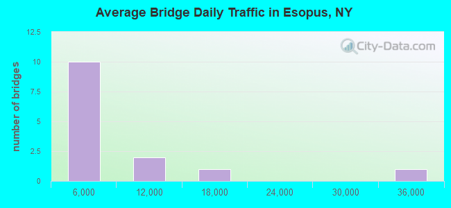
- 77,612Total average daily traffic
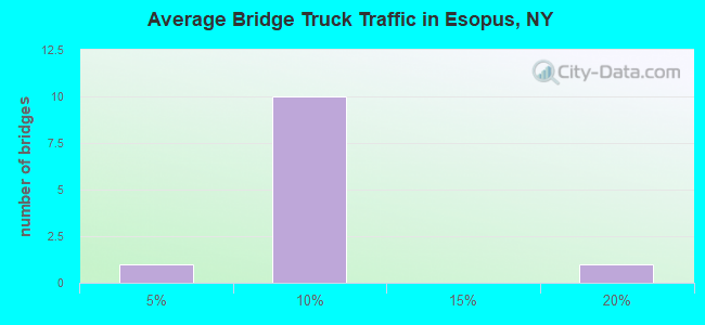
- 8,110Total average daily truck traffic
- National Bridge Inventory (NBI) Registered Bridges for Esopus
- No street view available for this location
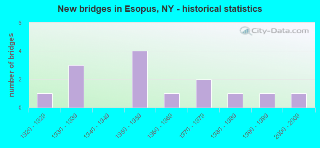
- New bridges - historical statistics
- 11920-1929
- 31930-1939
- 41950-1959
- 11960-1969
- 21970-1979
- 11980-1989
- 11990-1999
- 12000-2009
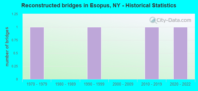
- Reconstructed bridges - Historical Statistics
- 11970-1979
- 01980-1989
- 11990-1999
- 02000-2009
- 12010-2019
- 12020-2022
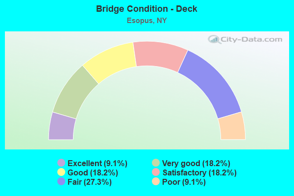
- Bridge Condition - Deck
- 9.1%Excellent
- 18.2%Very good
- 18.2%Good
- 18.2%Satisfactory
- 27.3%Fair
- 9.1%Poor
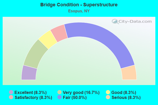
- Bridge Condition - Superstructure
- 8.3%Excellent
- 16.7%Very good
- 8.3%Good
- 8.3%Satisfactory
- 50.0%Fair
- 8.3%Serious
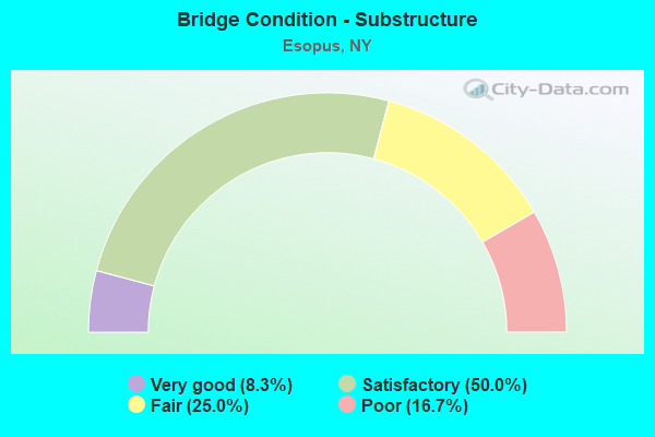
- Bridge Condition - Substructure
- 8.3%Very good
- 50.0%Satisfactory
- 25.0%Fair
- 16.7%Poor
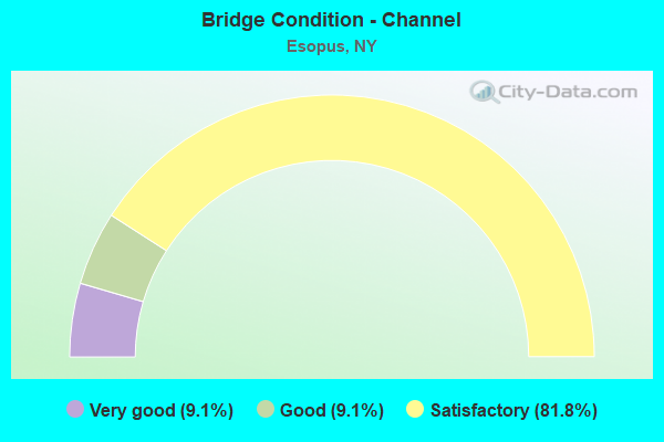
- Bridge Condition - Channel
- 9.1%Very good
- 9.1%Good
- 81.8%Satisfactory
Find on map >> Show street view
Structure Number: 100733, Location: IN WEST PARK (Lat: 41.792497, Lng: -73.960228), Route carried "on" structure: US 9W, Year Built: 1937, Year Reconstructed: 1981, Status: Open, Structure Length: 6.77m (22.21ft), Average Daily Traffic: 9,736 (year 2018), Truck Traffic: 5%, Average Future Daily Traffic: 9,828 (year 2040), Design Load: H 20, Features Intersected: CSXT RIVER LINE
Minimum Vertical Clearance: 30+ m (98+ ft), Kilometerpoint: 23.572, Lanes on structure: 2, Base Highway Network: Yes, Owner: State Highway Agency, Approaching Roadway Width: 9.1m (29.9ft), Material/Design: Steel, Design/Construction: Girder and Floorbeam System, Number Of Spans In Main Unit: 2, Length of Maximum Span: 32.6m (107.0ft), Curb-To-Curb Width: 13.3m (43.6ft), Out-to-Out Width: 14.6m (47.9ft)
Condition: Deck: Satisfactory, Superstructure: Fair, Substructure: Very good, Operating Rating: 64.4 metric tons, Method Used To Determine Operating Rating: Load Factor (LF), Inventory Rating: 38.1 metric tons, Method Used To Determine Inventory Rating: Load Factor (LF), Structural Evaluation: Somewhat better than minimum adequacy, Deck Geometry: Somewhat better than minimum adequacy, Underclear: Meets minimum limits, Approach Roadway Alignment: Equal to present desirable criteria, Length Of Structure Improvement: 6.76m (22.18ft), Designated Inspection Frequency: Every 24 months, Critical Feature Inspection Frequency: Every 24 months, Inspection Date: August 2021, Critical Feature Inspection Date: August 2021, Bridge Improvement Cost: $4,960,000, Roadway Improvement Cost: $2,904,000, Total Project Cost: $7,864,000 ( Estimate for 2021), Deck Structure Type: Concrete Cast-file-Place, Wearing Surface/Protective System: Wearing Surface: Integral Concrete, Deck Protection: Epoxy Coated Reinforcing
Find on map >> Show street view
Structure Number: 100734, Location: 5.4 MI N JCT RTS 9W+299 (Lat: 41.818372, Lng: -73.964239), Route carried "on" structure: US 9W, Year Built: 1930, Status: Open, Structure Length: 1.31m (4.30ft), Average Daily Traffic: 9,736 (year 2018), Truck Traffic: 5%, Average Future Daily Traffic: 9,828 (year 2040), Design Load: H 20, Features Intersected: BLACK CREEK
Minimum Vertical Clearance: 30+ m (98+ ft), Kilometerpoint: 26.597, Lanes on structure: 2, Base Highway Network: Yes, Owner: State Highway Agency, Approaching Roadway Width: 13.4m (44.0ft), Skew: 3 degrees, Material/Design: Concrete, Design/Construction: Tee Beam, Number Of Spans In Main Unit: 1, Length of Maximum Span: 10.9m (35.8ft), Curb-To-Curb Width: 13.4m (44.0ft), Out-to-Out Width: 14.6m (47.9ft)
Condition: Deck: Fair, Superstructure: Fair, Substructure: Satisfactory, Channel: Satisfactory, Operating Rating: 55.3 metric tons, Method Used To Determine Operating Rating: Load Factor (LF), Inventory Rating: 32.7 metric tons, Method Used To Determine Inventory Rating: Load Factor (LF), Structural Evaluation: Somewhat better than minimum adequacy, Deck Geometry: Equal to present minimum criteria, Waterway Adequacy: Somewhat better than minimum adequacy, Approach Roadway Alignment: Equal to present desirable criteria, Length Of Structure Improvement: 1.31m (4.30ft), Designated Inspection Frequency: Every 24 months, Underwater Inspection Frequency: Every 60 months, Inspection Date: August 2021, Underwater Inspection Date: March 2020, Bridge Improvement Cost: $746,000, Roadway Improvement Cost: $437,000, Total Project Cost: $1,183,000 ( Estimate for 2021), Deck Structure Type: Concrete Cast-file-Place, Wearing Surface/Protective System: Wearing Surface: Bituminous
Find on map >> Show street view
Structure Number: 104119, Location: 2.9 MI N JCT RTS 213+I87 (Lat: 41.850069, Lng: -74.035608), Route carried "on" structure: State highway 213, Year Built: 1931, Status: Open, Structure Length: 0.79m (2.59ft), Average Daily Traffic: 2,317 (year 2020), Truck Traffic: 5%, Average Future Daily Traffic: 2,866 (year 2040), Design Load: H 20, Features Intersected: SWARTE KILL
Minimum Vertical Clearance: 30+ m (98+ ft), Kilometerpoint: 32.920, Lanes on structure: 2, Base Highway Network: Yes, Owner: State Highway Agency, Approaching Roadway Width: 7.9m (25.9ft), Skew: 3 degrees, Material/Design: Concrete, Design/Construction: Slab, Number Of Spans In Main Unit: 1, Length of Maximum Span: 7.0m (23.0ft), Curb-To-Curb Width: 7.7m (25.3ft), Out-to-Out Width: 8.7m (28.5ft)
Condition: Deck: Satisfactory, Superstructure: Satisfactory, Substructure: Satisfactory, Channel: Satisfactory, Operating Rating: 66.2 metric tons, Method Used To Determine Operating Rating: Load Factor (LF), Inventory Rating: 39.0 metric tons, Method Used To Determine Inventory Rating: Load Factor (LF), Structural Evaluation: Equal to present minimum criteria, Deck Geometry: High priority of replacement, Waterway Adequacy: Equal to present minimum criteria, Approach Roadway Alignment: Meets minimum limits, Length Of Structure Improvement: 0.79m (2.59ft), Designated Inspection Frequency: Every 24 months, Inspection Date: September 2021, Bridge Improvement Cost: $388,000, Roadway Improvement Cost: $227,000, Total Project Cost: $615,000 ( Estimate for 2021), Wearing Surface/Protective System: Wearing Surface: Bituminous
Find on map >> Show street view
Structure Number: 10412, Location: JCT RTE 213+RONDOUT CR (Lat: 41.895122, Lng: -74.019133), Route carried "on" structure: State highway 213, Year Built: 1957, Year Reconstructed: 2017, Status: Posted for load-capacity, Structure Length: 10.85m (35.60ft), Average Daily Traffic: 2,317 (year 2020), Truck Traffic: 5%, Average Future Daily Traffic: 2,814 (year 2040), Design Load: HS 20, Features Intersected: RONDOUT CREEK
Minimum Vertical Clearance: 4.62m (15.16ft), Kilometerpoint: 38.246, Lanes on structure: 2, Base Highway Network: Yes, Owner: State Highway Agency, Approaching Roadway Width: 9.1m (29.9ft), Navigation Control: Yes ( Vertical Clearance: 999.9m (3,280.5ft), Horizontal Clearance: 4.6m (15.1ft)), Material/Design: Steel, Design/Construction: Arch - Thru, Number Of Spans In Main Unit: 1, Length of Maximum Span: 103.6m (339.9ft), Curb or Sidewalk Widths: Left: 1.6m (5.2ft), Right: 1.6m (5.2ft), Curb-To-Curb Width: 9.2m (30.2ft), Out-to-Out Width: 9.6m (31.5ft)
Condition: Deck: Excellent, Superstructure: Very good, Substructure: Satisfactory, Channel: Good, Operating Rating: 47.2 metric tons, Method Used To Determine Operating Rating: Load Factor (LF), Inventory Rating: 28.1 metric tons, Method Used To Determine Inventory Rating: Load Factor (LF), Structural Evaluation: Equal to present minimum criteria, Deck Geometry: Meets minimum limits, Waterway Adequacy: Equal to present minimum criteria, Approach Roadway Alignment: Meets minimum limits, Length Of Structure Improvement: 10.85m (35.60ft), Designated Inspection Frequency: Every 24 months, Inspection Date: September 2021, Bridge Improvement Cost: $9,111,000, Roadway Improvement Cost: $5,335,000, Total Project Cost: $14,446,000 ( Estimate for 2021), Deck Structure Type: Concrete Cast-file-Place, Wearing Surface/Protective System: Wearing Surface: Bituminous
Find on map >> Show street view
Structure Number: 1069749, Location: RT 9W AT KINGSTON S LINE (Lat: 41.918031, Lng: -73.981922), Route carried "on" structure: US 9W, Year Built: 1977, Status: Open, Structure Length: 29.47m (96.69ft), Average Daily Traffic: 16,168 (year 2020), Truck Traffic: 6%, Average Future Daily Traffic: 16,243 (year 2040), Design Load: HS 20, Features Intersected: East Strand Street, ROND
Minimum Vertical Clearance: 30+ m (98+ ft), Kilometerpoint: 37.892, Lanes on structure: 4, Lanes under structure: 2, Base Highway Network: Yes, Owner: State Highway Agency, Approaching Roadway Width: 21.9m (71.9ft), Skew: 30 degrees, Material/Design: Steel continuous, Design/Construction: Stringer/Multi-beam, Number Of Spans In Main Unit: 4, Length of Maximum Span: 108.2m (355.0ft), Curb-To-Curb Width: 21.8m (71.5ft), Out-to-Out Width: 25.0m (82.0ft)
Condition: Deck: Good, Superstructure: Fair, Substructure: Fair, Channel: Very good, Operating Rating: 38.6 metric tons, Method Used To Determine Operating Rating: Load and Resistance Factor Rating (LRFR) rating reported by rating factor(RF) method using HL-93 loadings, Inventory Rating: 29.8 metric tons, Method Used To Determine Inventory Rating: Load and Resistance Factor Rating (LRFR) rating reported by rating factor(RF) method using HL-93 loadings, Structural Evaluation: Somewhat better than minimum adequacy, Deck Geometry: Superior to present desirable criteria, Underclear: Better than present minimum criteria, Waterway Adequacy: Superior to present desirable criteria, Approach Roadway Alignment: Equal to present desirable criteria, Length Of Structure Improvement: 29.47m (96.69ft), Designated Inspection Frequency: Every 24 months, Underwater Inspection Frequency: Every 60 months, Inspection Date: September 2021, Underwater Inspection Date: May 2020, Bridge Improvement Cost: $27,345,000, Roadway Improvement Cost: $16,013,000, Total Project Cost: $43,358,000 ( Estimate for 2021), Deck Structure Type: Concrete Cast-file-Place, Wearing Surface/Protective System: Wearing Surface: Integral Concrete
Find on map >> Show street view
Structure Number: 22641, Location: 0.7 S OF ESOPUS (Lat: 41.817278, Lng: -73.964958), Route carried "on" structure: Other road , Year Built: 1925, Status: Open, Structure Length: 1.13m (3.71ft), Average Daily Traffic: 137 (year 2018), Truck Traffic: 8%, Average Future Daily Traffic: 192 (year 2038), Features Intersected: BLACK CREEK, Facility Carried by Structure: BLACK CREEK ROAD
Minimum Vertical Clearance: 30+ m (98+ ft), Kilometerpoint: 0.080, Lanes on structure: 2, Owner: Town or Township Highway Agency, Approaching Roadway Width: 7.3m (24.0ft), Material/Design: Concrete, Design/Construction: Arch - Deck, Number Of Spans In Main Unit: 1, Length of Maximum Span: 9.4m (30.8ft), Curb-To-Curb Width: 7.6m (24.9ft), Out-to-Out Width: 9.4m (30.8ft)
Condition: Superstructure: Fair, Substructure: Fair, Channel: Satisfactory, Operating Rating: 44.5 metric tons, Method Used To Determine Operating Rating: Field evaluation and documented engineering judgment, Inventory Rating: 12.6 metric tons, Method Used To Determine Inventory Rating: Field evaluation and documented engineering judgment, Structural Evaluation: Meets minimum limits, Deck Geometry: Somewhat better than minimum adequacy, Waterway Adequacy: Superior to present desirable criteria, Approach Roadway Alignment: Equal to present desirable criteria, Length Of Structure Improvement: 1.12m (3.67ft), Designated Inspection Frequency: Every 24 months, Inspection Date: August 2020, Bridge Improvement Cost: $363,000, Roadway Improvement Cost: $213,000, Total Project Cost: $576,000 ( Estimate for 2021), Wearing Surface/Protective System: Wearing Surface: Bituminous
Find on map >> Show street view
Structure Number: 226411, Location: 0.5MI S OF KINGSTON (Lat: 41.907742, Lng: -73.987669), Route carried "on" structure: Other road , Year Built: 1983, Status: Open, Structure Length: 0.82m (2.69ft), Average Daily Traffic: 1,258 (year 2017), Truck Traffic: 2%, Average Future Daily Traffic: 1,761 (year 2037), Features Intersected: PLANTASIA CREEK, Facility Carried by Structure: CONNELLY ROAD
Minimum Vertical Clearance: 30+ m (98+ ft), Kilometerpoint: 0.933, Lanes on structure: 2, Owner: County Highway Agency, Approaching Roadway Width: 7.6m (24.9ft), Material/Design: Concrete, Design/Construction: Slab, Number Of Spans In Main Unit: 1, Length of Maximum Span: 7.0m (23.0ft), Curb-To-Curb Width: 7.2m (23.6ft), Out-to-Out Width: 7.6m (24.9ft)
Condition: Deck: Fair, Superstructure: Fair, Substructure: Satisfactory, Channel: Satisfactory, Inventory Rating: 71.7 metric tons, Method Used To Determine Inventory Rating: Load Factor (LF), Structural Evaluation: Somewhat better than minimum adequacy, Deck Geometry: High priority of corrective action, Waterway Adequacy: Superior to present desirable criteria, Approach Roadway Alignment: High priority of corrective action, Length Of Structure Improvement: 0.82m (2.69ft), Designated Inspection Frequency: Every 24 months, Inspection Date: October 2020, Bridge Improvement Cost: $215,000, Roadway Improvement Cost: $126,000, Total Project Cost: $341,000 ( Estimate for 2021), Wearing Surface/Protective System: Wearing Surface: Bituminous
Find on map >> Show street view
Structure Number: 226426, Location: 0.5 MI SE OF RIFTON (Lat: 41.832394, Lng: -74.031792), Route carried "on" structure: Other road , Year Built: 1999, Status: Open, Structure Length: 0.79m (2.59ft), Average Daily Traffic: 303 (year 2017), Truck Traffic: 8%, Average Future Daily Traffic: 424 (year 2037), Features Intersected: SWARTE KILL, Facility Carried by Structure: HARDENBURG ROAD
Minimum Vertical Clearance: 30+ m (98+ ft), Kilometerpoint: 4.039, Lanes on structure: 2, Owner: Town or Township Highway Agency, Approaching Roadway Width: 7.9m (25.9ft), Material/Design: Concrete, Design/Construction: Frame, Number Of Spans In Main Unit: 1, Length of Maximum Span: 7.6m (24.9ft), Curb-To-Curb Width: 7.9m (25.9ft), Out-to-Out Width: 8.6m (28.2ft)
Condition: Deck: Good, Superstructure: Good, Substructure: Satisfactory, Channel: Satisfactory, Operating Rating: 60.8 metric tons, Method Used To Determine Operating Rating: Load Factor (LF), Inventory Rating: 36.3 metric tons, Method Used To Determine Inventory Rating: Load Factor (LF), Structural Evaluation: Equal to present minimum criteria, Deck Geometry: Somewhat better than minimum adequacy, Waterway Adequacy: Superior to present desirable criteria, Approach Roadway Alignment: High priority of corrective action, Length Of Structure Improvement: 0.79m (2.59ft), Designated Inspection Frequency: Every 24 months, Inspection Date: October 2021, Bridge Improvement Cost: $459,000, Roadway Improvement Cost: $269,000, Total Project Cost: $728,000 ( Estimate for 2021), Wearing Surface/Protective System: Wearing Surface: Bituminous, Membrane: Other
Find on map >> Show street view
Structure Number: 226443, Location: 1.1 MI NW OF WEST PARK (Lat: 41.801294, Lng: -73.977972), Route carried "on" structure: Other road , Year Built: 1954, Status: Posted for load, Structure Length: 0.91m (2.99ft), Average Daily Traffic: 27 (year 2017), Truck Traffic: 8%, Average Future Daily Traffic: 38 (year 2037), Features Intersected: BLACK CREEK, Facility Carried by Structure: VALLI ROAD
Minimum Vertical Clearance: 30+ m (98+ ft), Kilometerpoint: 0.772, Lanes on structure: 1, Owner: Town or Township Highway Agency, Approaching Roadway Width: 4.9m (16.1ft), Skew: 1 degrees, Material/Design: Steel, Design/Construction: Stringer/Multi-beam, Number Of Spans In Main Unit: 1, Length of Maximum Span: 7.6m (24.9ft), Curb-To-Curb Width: 4.7m (15.4ft), Out-to-Out Width: 4.9m (16.1ft)
Condition: Deck: Fair, Superstructure: Serious, Substructure: Poor, Channel: Satisfactory, Operating Rating: 9.1 metric tons, Method Used To Determine Operating Rating: Load Factor (LF), Inventory Rating: 5.4 metric tons, Method Used To Determine Inventory Rating: Load Factor (LF), Structural Evaluation: High priority of corrective action, Deck Geometry: Better than present minimum criteria, Waterway Adequacy: Meets minimum limits, Approach Roadway Alignment: Somewhat better than minimum adequacy, Bridge Posting: Required (Relationship of Operating Rating to Maximum Legal Load: > 39.9% below), Length Of Structure Improvement: 0.91m (2.99ft), Designated Inspection Frequency: Every 12 months, Inspection Date: June 2021, Bridge Improvement Cost: $281,000, Roadway Improvement Cost: $165,000, Total Project Cost: $446,000 ( Estimate for 2021), Deck Structure Type: Corrugated Steel, Wearing Surface/Protective System: Wearing Surface: Bituminous
Find on map >> Show street view
Structure Number: 334784, Location: 1.2 MI NW OF WEST PARK (Lat: 41.806703, Lng: -73.972928), Route carried "on" structure: Other road , Year Built: 1967, Year Reconstructed: 2020, Status: Open, Structure Length: 1.25m (4.10ft), Average Daily Traffic: 330 (year 2018), Truck Traffic: 6%, Average Future Daily Traffic: 462 (year 2038), Design Load: HL 93, Features Intersected: BLACK CREEK, Facility Carried by Structure: FLOYD ACKERT ROAD
Minimum Vertical Clearance: 30+ m (98+ ft), Kilometerpoint: 2.220, Lanes on structure: 2, Owner: County Highway Agency, Approaching Roadway Width: 7.6m (24.9ft), Material/Design: Steel, Design/Construction: Stringer/Multi-beam, Number Of Spans In Main Unit: 1, Length of Maximum Span: 11.9m (39.0ft), Curb-To-Curb Width: 7.6m (24.9ft), Out-to-Out Width: 7.9m (25.9ft)
Condition: Deck: Very good, Superstructure: Excellent, Substructure: Satisfactory, Channel: Satisfactory, Inventory Rating: 62.6 metric tons, Method Used To Determine Inventory Rating: Load Factor (LF), Structural Evaluation: Equal to present minimum criteria, Deck Geometry: Somewhat better than minimum adequacy, Waterway Adequacy: Somewhat better than minimum adequacy, Approach Roadway Alignment: Equal to present minimum criteria, Length Of Structure Improvement: 1.24m (4.07ft), Designated Inspection Frequency: Every 24 months, Inspection Date: December 2020, Bridge Improvement Cost: $404,000, Roadway Improvement Cost: $236,000, Total Project Cost: $640,000 ( Estimate for 2021), Deck Structure Type: Concrete Precast Panels, Wearing Surface/Protective System: Wearing Surface: Bituminous, Membrane: Other
Find on map >> Show street view
Structure Number: 337138, Location: 0.12 Mi W Jct 9W CR82 (Lat: 41.826503, Lng: -73.968914), Route carried "on" structure: ServiceCounty highway , Year Built: 2009, Status: Open, Structure Length: 0.98m (3.22ft), Average Daily Traffic: 443 (year 2020), Truck Traffic: 8%, Average Future Daily Traffic: 620 (year 2040), Design Load: HS 25 or greater, Features Intersected: Trib. Black Creek, Facility Carried by Structure: County Road 82
Minimum Vertical Clearance: 32.69m (107.25ft), Kilometerpoint: 10.169, Lanes on structure: 2, Owner: County Highway Agency, Approaching Roadway Width: 6.1m (20.0ft), Material/Design: Steel, Design/Construction: Stringer/Multi-beam, Number Of Spans In Main Unit: 1, Length of Maximum Span: 8.8m (28.9ft), Curb-To-Curb Width: 6.4m (21.0ft), Out-to-Out Width: 6.7m (22.0ft)
Condition: Deck: Very good, Superstructure: Very good, Substructure: Poor, Channel: Satisfactory, Operating Rating: 66.4 metric tons, Method Used To Determine Operating Rating: Load and Resistance Factor Rating (LRFR) rating reported by rating factor(RF) method using HL-93 loadings, Inventory Rating: 51.2 metric tons, Method Used To Determine Inventory Rating: Load and Resistance Factor Rating (LRFR) rating reported by rating factor(RF) method using HL-93 loadings, Structural Evaluation: Meets minimum limits, Deck Geometry: High priority of corrective action, Waterway Adequacy: Superior to present desirable criteria, Approach Roadway Alignment: Better than present minimum criteria, Length Of Structure Improvement: 0.97m (3.18ft), Designated Inspection Frequency: Every 24 months, Inspection Date: June 2021, Bridge Improvement Cost: $224,000, Roadway Improvement Cost: $131,000, Total Project Cost: $356,000 ( Estimate for 2021), Deck Structure Type: Concrete Precast Panels, Wearing Surface/Protective System: Wearing Surface: Bituminous
Find on map >> Show street view
Structure Number: 5041189, Location: 1.2 MI S OF TILLSON (Lat: 41.817028, Lng: -74.055983), Route carried "on" structure: Interstate 87, Year Built: 1955, Year Reconstructed: 1998, Status: Open, Structure Length: 11.00m (36.09ft), Average Daily Traffic: 32,350 (year 2018), Truck Traffic: 18%, Average Future Daily Traffic: 54,781 (year 2040), Design Load: HS 20+Mod, Features Intersected: RTE 213, WALLKILL RIVER
Minimum Vertical Clearance: 30+ m (98+ ft), Kilometerpoint: 24.569, Lanes on structure: 4, Lanes under structure: 2, Base Highway Network: Yes, Toll: On Interstate toll segment, Owner: State Toll Authority, Approaching Roadway Width: 33.5m (109.9ft), Skew: 32 degrees, Material/Design: Steel continuous, Design/Construction: Stringer/Multi-beam, Number Of Spans In Main Unit: 3, Length of Maximum Span: 24.1m (79.1ft), Curb-To-Curb Width: 33.5m (109.9ft), Out-to-Out Width: 34.4m (112.9ft)
Condition: Deck: Poor, Superstructure: Fair, Substructure: Fair, Channel: Satisfactory, Operating Rating: 89.8 metric tons, Method Used To Determine Operating Rating: Load Factor (LF), Inventory Rating: 54.4 metric tons, Method Used To Determine Inventory Rating: Load Factor (LF), Structural Evaluation: Somewhat better than minimum adequacy, Deck Geometry: Superior to present desirable criteria, Underclear: Somewhat better than minimum adequacy, Waterway Adequacy: Meets minimum limits, Approach Roadway Alignment: Equal to present desirable criteria, Length Of Structure Improvement: 11.00m (36.09ft), Designated Inspection Frequency: Every 24 months, Inspection Date: May 2021, Bridge Improvement Cost: $15,334,000, Roadway Improvement Cost: $8,979,000, Total Project Cost: $24,313,000 ( Estimate for 2021), Deck Structure Type: Concrete Cast-file-Place, Wearing Surface/Protective System: Wearing Surface: Bituminous, Membrane: Other
Find on map >> Show street view
Structure Number: 1069749, Location: RT 9W AT KINGSTON S LINE (Lat: 41.918031, Lng: -73.981922), Route carried "under" structure: City street , Year Built: 1977, Structure Length: 0. m, Average Daily Traffic: 100 (year 2002), Features Intersected: East Strand Street, ROND, Facility Carried by Structure: RTE 9W
Minimum Vertical Clearance: 11.27m (36.98ft), Kilometerpoint: 0.000, Lanes on structure: 4, Lanes under structure: 2, Material/Design: Steel continuous, Design/Construction: Stringer/Multi-beam, Length of Maximum Span: 108.2m (355.0ft)
Find on map >> Show street view
Structure Number: 5041189, Location: 1.2 MI S OF TILLSON (Lat: 41.817028, Lng: -74.055983), Route carried "under" structure: State highway 213, Year Built: 1955, Structure Length: 0. m, Average Daily Traffic: 2,390 (year 2002), Features Intersected: RTE 213, WALLKILL RIVER, Facility Carried by Structure: RTE I87
Minimum Vertical Clearance: 5.03m (16.50ft), Kilometerpoint: 28.158, Lanes on structure: 4, Lanes under structure: 2, Material/Design: Steel continuous, Design/Construction: Stringer/Multi-beam, Length of Maximum Span: 24.1m (79.1ft)