Bridge Statistics for Ensley, Florida (FL)
Condition, Traffic, Stress, Structural Evaluation, Project Costs
- National Bridge Inventory (NBI) Statistics
- 13Number of bridges
- 85ft / 26.5mTotal length
- 225,851Total average daily traffic
- 18,439Total average daily truck traffic
- National Bridge Inventory (NBI) Registered Bridges for Ensley
- No street view available for this location
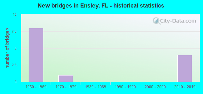
- New bridges - historical statistics
- 81960-1969
- 11970-1979
- 42010-2019


- Bridge Condition - Deck
- 33.3%Very good
- 33.3%Good
- 33.3%Satisfactory

- Bridge Condition - Superstructure
- 33.3%Very good
- 50.0%Good
- 16.7%Satisfactory

- Bridge Condition - Substructure
- 33.3%Excellent
- 50.0%Good
- 16.7%Fair

- Bridge Condition - Channel
- 33.3%Excellent
- 66.7%Good

- Bridge Condition - Culverts
- 33.3%Very good
- 33.3%Good
- 33.3%Satisfactory
Find on map >> Show street view
Structure Number: 480019, Location: 0.8mi South of I10 (Lat: 30.509175, Lng: -87.307947), Route carried "on" structure: State highway 297, Year Built: 1968, Status: Open, Structure Length: 0.95m (3.12ft), Average Daily Traffic: 32,500 (year 2020), Truck Traffic: 8%, Average Future Daily Traffic: 56,388 (year 2042), Design Load: HS 20, Features Intersected: Eight Mile Creek
Minimum Vertical Clearance: 30+ m (98+ ft), Kilometerpoint: 4.012, Lanes on structure: 4, Owner: State Highway Agency, Approaching Roadway Width: 18.3m (60.0ft), Skew: 10 degrees, Material/Design: Concrete, Design/Construction: Culvert, Number Of Spans In Main Unit: 3, Length of Maximum Span: 3.0m (9.8ft)
Condition: Channel: Good, Culverts: Satisfactory, Operating Rating: 53.6 metric tons, Method Used To Determine Operating Rating: Load Factor (LF), Inventory Rating: 32.1 metric tons, Method Used To Determine Inventory Rating: Load Factor (LF), Structural Evaluation: Equal to present minimum criteria, Waterway Adequacy: Equal to present desirable criteria, Approach Roadway Alignment: Equal to present desirable criteria, Designated Inspection Frequency: Every 24 months, Inspection Date: April 2020
Find on map >> Show street view
Structure Number: 480024, Location: 0.5 Miles West of I110 (Lat: 30.468994, Lng: -87.236539), Route carried "on" structure: State highway 296, Year Built: 1967, Status: Open, Structure Length: 8.85m (29.04ft), Average Daily Traffic: 29,500 (year 2020), Truck Traffic: 4%, Average Future Daily Traffic: 51,182 (year 2042), Design Load: HS 20, Features Intersected: CSX RR and City Streets
Minimum Vertical Clearance: 30+ m (98+ ft), Kilometerpoint: 6.312, Lanes on structure: 4, Lanes under structure: 4, Owner: State Highway Agency, Approaching Roadway Width: 14.6m (47.9ft), Skew: 10 degrees, Material/Design: Prestressed concrete, Design/Construction: Stringer/Multi-beam, Number Of Spans In Main Unit: 5, Length of Maximum Span: 19.4m (63.6ft), Curb or Sidewalk Widths: Left: 1.4m (4.6ft), Right: 1.4m (4.6ft), Curb-To-Curb Width: 18.0m (59.1ft), Out-to-Out Width: 22.6m (74.1ft)
Condition: Deck: Satisfactory, Superstructure: Good, Substructure: Good, Operating Rating: 81.6 metric tons, Method Used To Determine Operating Rating: Load Factor (LF), Inventory Rating: 50.8 metric tons, Method Used To Determine Inventory Rating: Load Factor (LF), Structural Evaluation: Better than present minimum criteria, Deck Geometry: Somewhat better than minimum adequacy, Underclear: Meets minimum limits, Approach Roadway Alignment: Equal to present desirable criteria, Designated Inspection Frequency: Every 24 months, Inspection Date: June 2020, Deck Structure Type: Concrete Cast-file-Place
Find on map >> Show street view
Structure Number: 480056, Location: 0.1MI East of US29 (Lat: 30.502767, Lng: -87.263569), Route carried "on" structure: Interstate 10, Year Built: 1961, Year Reconstructed: 2017, Status: Open, Structure Length: 3.54m (11.61ft), Average Daily Traffic: 42,750 (year 2020), Truck Traffic: 9%, Average Future Daily Traffic: 74,171 (year 2042), Design Load: HL 93, Features Intersected: I10 SR8 WB On Ramp
Minimum Vertical Clearance: 30+ m (98+ ft), Kilometerpoint: 16.740, Lanes on structure: 3, Lanes under structure: 1, Base Highway Network: Yes, Owner: State Highway Agency, Approaching Roadway Width: 17.1m (56.1ft), Material/Design: Prestressed concrete, Design/Construction: Stringer/Multi-beam, Number Of Spans In Main Unit: 3, Length of Maximum Span: 16.5m (54.1ft), Curb-To-Curb Width: 17.1m (56.1ft), Out-to-Out Width: 18.0m (59.1ft)
Condition: Deck: Good, Superstructure: Good, Substructure: Good, Operating Rating: 48.4 metric tons, Method Used To Determine Operating Rating: Load and Resistance Factor (LRFR), Inventory Rating: 38.8 metric tons, Method Used To Determine Inventory Rating: Load and Resistance Factor (LRFR), Structural Evaluation: Better than present minimum criteria, Deck Geometry: Equal to present minimum criteria, Underclear: Somewhat better than minimum adequacy, Approach Roadway Alignment: Equal to present desirable criteria, Designated Inspection Frequency: Every 24 months, Inspection Date: July 2021, Deck Structure Type: Concrete Cast-file-Place
Find on map >> Show street view
Structure Number: 480057, Location: 0.4MI East of US29 SR95 (Lat: 30.503969, Lng: -87.258575), Route carried "on" structure: County highway 95A, Year Built: 1961, Status: Open, Structure Length: 7.25m (23.79ft), Average Daily Traffic: 19,500 (year 2020), Truck Traffic: 9%, Average Future Daily Traffic: 33,832 (year 2042), Design Load: HS 20, Features Intersected: I10 SR8
Minimum Vertical Clearance: 30+ m (98+ ft), Kilometerpoint: 4.157, Lanes on structure: 2, Lanes under structure: 6, Owner: State Highway Agency, Approaching Roadway Width: 7.3m (24.0ft), Skew: 2 degrees, Material/Design: Prestressed concrete, Design/Construction: Stringer/Multi-beam, Number Of Spans In Main Unit: 4, Length of Maximum Span: 22.9m (75.1ft), Curb or Sidewalk Widths: Left: 0.6m (2.0ft), Right: 0.6m (2.0ft), Curb-To-Curb Width: 8.5m (27.9ft), Out-to-Out Width: 10.4m (34.1ft)
Condition: Deck: Satisfactory, Superstructure: Good, Substructure: Good, Operating Rating: 68.9 metric tons, Method Used To Determine Operating Rating: Load Factor (LF), Inventory Rating: 41.7 metric tons, Method Used To Determine Inventory Rating: Load Factor (LF), Structural Evaluation: Better than present minimum criteria, Deck Geometry: Meets minimum limits, Underclear: Equal to present minimum criteria, Approach Roadway Alignment: Equal to present desirable criteria, Designated Inspection Frequency: Every 24 months, Inspection Date: April 2020, Deck Structure Type: Concrete Cast-file-Place
Find on map >> Show street view
Structure Number: 484071, Location: 0.55Mi Eof Pine Forest Rd (Lat: 30.515069, Lng: -87.302567), Route carried "on" structure: County highway , Year Built: 1970, Year Reconstructed: 2019, Status: Posted for load, Structure Length: 1.89m (6.20ft), Average Daily Traffic: 1,600 (year 2020), Truck Traffic: 7%, Average Future Daily Traffic: 2,776 (year 2042), Features Intersected: 8 Mile Creek, Facility Carried by Structure: Interstate Circle
Minimum Vertical Clearance: 30+ m (98+ ft), Kilometerpoint: 1.904, Lanes on structure: 2, Owner: County Highway Agency, Approaching Roadway Width: 6.4m (21.0ft), Material/Design: Wood or Timber, Design/Construction: Stringer/Multi-beam, Number Of Spans In Main Unit: 4, Length of Maximum Span: 4.9m (16.1ft), Curb or Sidewalk Widths: Left: 0.2m (0.7ft), Right: 0.2m (0.7ft), Curb-To-Curb Width: 6.6m (21.7ft), Out-to-Out Width: 7.2m (23.6ft)
Condition: Deck: Good, Superstructure: Satisfactory, Substructure: Fair, Channel: Good, Operating Rating: 10.3 metric tons, Method Used To Determine Operating Rating: Load and Resistance Factor (LRFR), Inventory Rating: 7.9 metric tons, Method Used To Determine Inventory Rating: Load and Resistance Factor (LRFR), Structural Evaluation: High priority of corrective action, Deck Geometry: High priority of replacement, Waterway Adequacy: Better than present minimum criteria, Approach Roadway Alignment: Equal to present desirable criteria, Bridge Posting: Required (Relationship of Operating Rating to Maximum Legal Load: > 39.9% below), Designated Inspection Frequency: Every 24 months, Other Special Inspection Frequency: Every 12 months, Inspection Date: November 2020, Other Special Inspection Date: November 2021, Deck Structure Type: Concrete Cast-file-Place
Find on map >> Show street view
Structure Number: 484244, Location: 0.3 Mi S of US90 (Lat: 30.528350, Lng: -87.249869), Route carried "on" structure: County highway , Year Built: 2011, Status: Open, Structure Length: 0.79m (2.59ft), Average Daily Traffic: 500 (year 2020), Truck Traffic: 1%, Average Future Daily Traffic: 868 (year 2042), Design Load: HL 93, Features Intersected: Drainage Ditch, Facility Carried by Structure: Airway Drive
Minimum Vertical Clearance: 30+ m (98+ ft), Kilometerpoint: 0.000, Lanes on structure: 2, Owner: County Highway Agency, Approaching Roadway Width: 6.9m (22.6ft), Material/Design: Concrete, Design/Construction: Culvert, Number Of Spans In Main Unit: 2, Length of Maximum Span: 4.0m (13.1ft), Curb or Sidewalk Widths: Left: 2.7m (8.9ft), Right: 2.7m (8.9ft)
Condition: Channel: Good, Culverts: Good, Operating Rating: 50.8 metric tons, Method Used To Determine Operating Rating: Load and Resistance Factor (LRFR), Inventory Rating: 39.0 metric tons, Method Used To Determine Inventory Rating: Load and Resistance Factor (LRFR), Structural Evaluation: Better than present minimum criteria, Waterway Adequacy: Better than present minimum criteria, Approach Roadway Alignment: Equal to present desirable criteria, Designated Inspection Frequency: Every 24 months, Inspection Date: July 2020
Find on map >> Show street view
Structure Number: 484274, Location: 0.97Mi West of SR95 US29 (Lat: 30.519167, Lng: -87.289028), Route carried "on" structure: County highway , Year Built: 2018, Status: Open, Structure Length: 0.94m (3.08ft), Average Daily Traffic: 6,700 (year 2020), Truck Traffic: 5%, Average Future Daily Traffic: 11,625 (year 2042), Design Load: HL 93, Features Intersected: 8 Mile Creek, Facility Carried by Structure: Detroit Blvd
Minimum Vertical Clearance: 30.18m (99.02ft), Kilometerpoint: 2.573, Lanes on structure: 2, Owner: County Highway Agency, Approaching Roadway Width: 8.2m (26.9ft), Material/Design: Prestressed concrete, Design/Construction: Slab, Number Of Spans In Main Unit: 1, Length of Maximum Span: 9.4m (30.8ft), Curb or Sidewalk Widths: Left: 1.5m (4.9ft), Right: 0.0m, Curb-To-Curb Width: 10.1m (33.1ft), Out-to-Out Width: 12.6m (41.3ft)
Condition: Deck: Very good, Superstructure: Very good, Substructure: Excellent, Channel: Excellent, Operating Rating: 56.8 metric tons, Method Used To Determine Operating Rating: Load and Resistance Factor (LRFR), Inventory Rating: 43.7 metric tons, Method Used To Determine Inventory Rating: Load and Resistance Factor (LRFR), Structural Evaluation: Equal to present desirable criteria, Deck Geometry: Meets minimum limits, Waterway Adequacy: Equal to present desirable criteria, Approach Roadway Alignment: Equal to present desirable criteria, Designated Inspection Frequency: Every 24 months, Inspection Date: December 2020, Deck Structure Type: Concrete Precast Panels
Find on map >> Show street view
Structure Number: 484275, Location: 0.03Mi N of Detroit Blvd (Lat: 30.521331, Lng: -87.291647), Route carried "on" structure: County highway , Year Built: 2018, Status: Open, Structure Length: 0.94m (3.08ft), Average Daily Traffic: 500 (year 2020), Average Future Daily Traffic: 868 (year 2042), Design Load: HL 93, Features Intersected: 8 Mile Creek, Facility Carried by Structure: Cove Ave
Minimum Vertical Clearance: 30.18m (99.02ft), Kilometerpoint: 0.048, Lanes on structure: 2, Owner: County Highway Agency, Approaching Roadway Width: 7.3m (24.0ft), Material/Design: Prestressed concrete, Design/Construction: Slab, Number Of Spans In Main Unit: 1, Length of Maximum Span: 9.4m (30.8ft), Curb-To-Curb Width: 9.8m (32.2ft), Out-to-Out Width: 10.6m (34.8ft)
Condition: Deck: Very good, Superstructure: Very good, Substructure: Excellent, Channel: Excellent, Operating Rating: 49.6 metric tons, Method Used To Determine Operating Rating: Load and Resistance Factor (LRFR), Inventory Rating: 38.6 metric tons, Method Used To Determine Inventory Rating: Load and Resistance Factor (LRFR), Structural Evaluation: Equal to present desirable criteria, Deck Geometry: Equal to present minimum criteria, Waterway Adequacy: Equal to present desirable criteria, Approach Roadway Alignment: Equal to present desirable criteria, Designated Inspection Frequency: Every 24 months, Inspection Date: December 2020, Deck Structure Type: Concrete Precast Panels
Find on map >> Show street view
Structure Number: 484276, Location: 0.02Mi S of W Detroit Blv (Lat: 30.518567, Lng: -87.296936), Route carried "on" structure: County highway , Year Built: 2016, Status: Open, Structure Length: 1.33m (4.36ft), Average Daily Traffic: 101 (year 2020), Truck Traffic: 10%, Average Future Daily Traffic: 130 (year 2042), Design Load: HL 93, Features Intersected: 8 Mile Creek, Facility Carried by Structure: Ashland Ave
Minimum Vertical Clearance: 30+ m (98+ ft), Kilometerpoint: 0.623, Lanes on structure: 2, Owner: County Highway Agency, Approaching Roadway Width: 8.2m (26.9ft), Material/Design: Concrete, Design/Construction: Culvert, Number Of Spans In Main Unit: 1, Length of Maximum Span: 13.3m (43.6ft), Curb or Sidewalk Widths: Left: 2.0m (6.6ft), Right: 2.0m (6.6ft), Curb-To-Curb Width: 8.2m (26.9ft), Out-to-Out Width: 12.8m (42.0ft)
Condition: Channel: Good, Culverts: Very good, Operating Rating: 47.3 metric tons, Method Used To Determine Operating Rating: Load and Resistance Factor (LRFR), Inventory Rating: 38.9 metric tons, Method Used To Determine Inventory Rating: Load and Resistance Factor (LRFR), Structural Evaluation: Equal to present desirable criteria, Deck Geometry: Somewhat better than minimum adequacy, Waterway Adequacy: Equal to present desirable criteria, Approach Roadway Alignment: Equal to present desirable criteria, Designated Inspection Frequency: Every 24 months, Underwater Inspection Frequency: Every 24 months, Inspection Date: May 2020, Underwater Inspection Date: May 2020
Find on map >> Show street view
Structure Number: 480024, Location: 0.5 Miles West of I110 (Lat: 30.468994, Lng: -87.236539), Route carried "under" structure: ServiceCity street , Year Built: 1967, Structure Length: 0. m, Average Daily Traffic: 2,000 (year 1999), Truck Traffic: 9%, Features Intersected: CSX RR and City Streets, Facility Carried by Structure: SR296 Brent Lane
Minimum Vertical Clearance: 7.19m (23.59ft), Kilometerpoint: 0.000, Lanes on structure: 4, Lanes under structure: 2, Material/Design: Prestressed concrete, Design/Construction: Stringer/Multi-beam, Length of Maximum Span: 19.4m (63.6ft)
Find on map >> Show street view
Structure Number: 480056, Location: 0.1MI East of US29 (Lat: 30.502767, Lng: -87.263569), Route carried "under" structure: Ramp Other road 10, Year Built: 1961, Structure Length: 0. m, Average Daily Traffic: 2,700 (year 1999), Truck Traffic: 20%, Features Intersected: I10 SR8 WB On Ramp
Minimum Vertical Clearance: 5.18m (16.99ft), Kilometerpoint: 16.744, Lanes on structure: 3, Lanes under structure: 1, Material/Design: Prestressed concrete, Design/Construction: Stringer/Multi-beam, Length of Maximum Span: 16.5m (54.1ft)
Find on map >> Show street view
Structure Number: 480057, Location: 0.4MI East of US29 SR95 (Lat: 30.503969, Lng: -87.258575), Route carried "under" structure: Interstate 10, Year Built: 1961, Structure Length: 0. m, Average Daily Traffic: 85,500 (year 2020), Truck Traffic: 9%, Features Intersected: I10 SR8, Facility Carried by Structure: CR95A Palafox
Minimum Vertical Clearance: 4.88m (16.01ft), Kilometerpoint: 17.257, Lanes on structure: 2, Lanes under structure: 6, Material/Design: Prestressed concrete, Design/Construction: Stringer/Multi-beam, Length of Maximum Span: 22.9m (75.1ft)