Bridge Statistics for Edgewood, Maryland (MD)
Condition, Traffic, Stress, Structural Evaluation, Project Costs
- National Bridge Inventory (NBI) Statistics
- 23Number of bridges
- 318ft / 97.4mTotal length
- $398,000Total costs
- 490,989Total average daily traffic
- 32,776Total average daily truck traffic
- National Bridge Inventory (NBI) Registered Bridges for Edgewood
- No street view available for this location
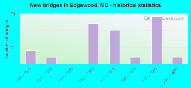
- New bridges - historical statistics
- 21930-1939
- 11940-1949
- 61960-1969
- 51970-1979
- 11980-1989
- 71990-1999
- 12000-2009

- Reconstructed bridges - Historical Statistics
- 21960-1969
- 01970-1979
- 31980-1989
- 31990-1999


- Bridge Condition - Deck
- 6.7%Very good
- 66.7%Good
- 20.0%Satisfactory
- 6.7%Serious

- Bridge Condition - Superstructure
- 6.7%Very good
- 46.7%Good
- 33.3%Satisfactory
- 6.7%Fair
- 6.7%Poor

- Bridge Condition - Substructure
- 6.7%Very good
- 46.7%Good
- 26.7%Satisfactory
- 20.0%Fair

- Bridge Condition - Channel
- 9.1%Very good
- 36.4%Good
- 45.5%Satisfactory
- 9.1%Fair

- Bridge Condition - Culverts
- 60.0%Good
- 20.0%Satisfactory
- 20.0%Fair
Find on map >> Show street view
Structure Number: 10000012001101, Location: 0.33 M S OF EDGEWOOD ROAD (Lat: 39.443183, Lng: -76.315353), Route carried "on" structure: State highway 7, Year Built: 1991, Status: Open, Structure Length: 4.18m (13.71ft), Average Daily Traffic: 7,300 (year 2009), Truck Traffic: 8%, Average Future Daily Traffic: 9,040 (year 2026), Design Load: HS 25 or greater, Features Intersected: WINTERS RUN
Minimum Vertical Clearance: 30+ m (98+ ft), Kilometerpoint: 5.953, Lanes on structure: 2, Owner: State Highway Agency, Approaching Roadway Width: 12.2m (40.0ft), Skew: 4 degrees, Material/Design: Steel continuous, Design/Construction: Stringer/Multi-beam, Number Of Spans In Main Unit: 2, Length of Maximum Span: 19.8m (65.0ft), Curb-To-Curb Width: 12.2m (40.0ft), Out-to-Out Width: 13.4m (44.0ft)
Condition: Deck: Good, Superstructure: Good, Substructure: Good, Channel: Good, Inventory Rating: 84.8 metric tons, Method Used To Determine Inventory Rating: Load Factor (LF), Structural Evaluation: Better than present minimum criteria, Deck Geometry: Somewhat better than minimum adequacy, Waterway Adequacy: Better than present minimum criteria, Approach Roadway Alignment: Equal to present desirable criteria, Length Of Structure Improvement: 4.18m (13.71ft), Designated Inspection Frequency: Every 24 months, Inspection Date: October 2021, Bridge Improvement Cost: $362,000, Roadway Improvement Cost: $36,000, Total Project Cost: $398,000, Deck Structure Type: Concrete Cast-file-Place, Wearing Surface/Protective System: Wearing Surface: Bituminous
Find on map >> Show street view
Structure Number: 10000012002702, Location: 0.41 MILE EAST OF MD 24 (Lat: 39.439394, Lng: -76.296203), Route carried "on" structure: US 40, Year Built: 1994, Status: Open, Structure Length: 1.74m (5.71ft), Average Daily Traffic: 21,614 (year 2013), Truck Traffic: 8%, Average Future Daily Traffic: 31,640 (year 2029), Design Load: HS 25 or greater, Features Intersected: BR OF OTTER POINT CREEK
Minimum Vertical Clearance: 30+ m (98+ ft), Kilometerpoint: 7.128, Lanes on structure: 4, Base Highway Network: Yes, Owner: State Highway Agency, Approaching Roadway Width: 28.7m (94.2ft), Skew: 20 degrees, Material/Design: Concrete, Design/Construction: Culvert, Length of Maximum Span: 4.3m (14.1ft), Curb-To-Curb Width: 29.9m (98.1ft), Out-to-Out Width: 30.9m (101.4ft)
Condition: Channel: Satisfactory, Culverts: Good, Operating Rating: 45.4 metric tons, Method Used To Determine Operating Rating: Allowable Stress (AS), Inventory Rating: 29.0 metric tons, Method Used To Determine Inventory Rating: Allowable Stress (AS), Structural Evaluation: Better than present minimum criteria, Deck Geometry: Superior to present desirable criteria, Waterway Adequacy: Equal to present desirable criteria, Approach Roadway Alignment: Equal to present desirable criteria, Designated Inspection Frequency: Every 24 months, Inspection Date: June 2021, Deck Structure Type: Concrete Cast-file-Place, Wearing Surface/Protective System: Wearing Surface: Bituminous
Find on map >> Show street view
Structure Number: 10000012002801, Location: 0.10 MILE EAST OF MD 24 (Lat: 39.437383, Lng: -76.301319), Route carried "on" structure: US 40, Year Built: 1935, Year Reconstructed: 1985, Status: Open, Structure Length: 4.02m (13.19ft), Average Daily Traffic: 21,093 (year 2009), Truck Traffic: 8%, Average Future Daily Traffic: 31,640 (year 2029), Design Load: HS 20, Features Intersected: OTTER POINT CREEK
Minimum Vertical Clearance: 30+ m (98+ ft), Kilometerpoint: 6.629, Lanes on structure: 4, Base Highway Network: Yes, Owner: State Highway Agency, Approaching Roadway Width: 28.7m (94.2ft), Material/Design: Steel, Design/Construction: Stringer/Multi-beam, Number Of Spans In Main Unit: 2, Length of Maximum Span: 19.5m (64.0ft), Curb-To-Curb Width: 26.8m (87.9ft), Out-to-Out Width: 27.8m (91.2ft)
Condition: Deck: Good, Superstructure: Satisfactory, Substructure: Satisfactory, Channel: Satisfactory, Operating Rating: 68.0 metric tons, Method Used To Determine Operating Rating: Load Factor (LF), Inventory Rating: 40.8 metric tons, Method Used To Determine Inventory Rating: Load Factor (LF), Structural Evaluation: Equal to present minimum criteria, Deck Geometry: Superior to present desirable criteria, Waterway Adequacy: Equal to present minimum criteria, Approach Roadway Alignment: Equal to present desirable criteria, Designated Inspection Frequency: Every 24 months, Inspection Date: August 2020, Deck Structure Type: Concrete Cast-file-Place, Wearing Surface/Protective System: Wearing Surface: Monolithic Concrete, Deck Protection: Epoxy Coated Reinforcing
Find on map >> Show street view
Structure Number: 10000012003601, Location: 0.25 MILE NORTH OF US 40 (Lat: 39.434369, Lng: -76.339981), Route carried "on" structure: State highway 152, Year Built: 1971, Year Reconstructed: 1996, Status: Open, Structure Length: 6.10m (20.01ft), Average Daily Traffic: 24,672 (year 2009), Truck Traffic: 8%, Average Future Daily Traffic: 31,593 (year 2026), Design Load: HS 20, Features Intersected: CSX TRANSPORTATION
Minimum Vertical Clearance: 30+ m (98+ ft), Kilometerpoint: 4.232, Lanes on structure: 4, Base Highway Network: Yes, Owner: State Highway Agency, Approaching Roadway Width: 20.7m (67.9ft), Skew: 22 degrees, Material/Design: Steel continuous, Design/Construction: Stringer/Multi-beam, Number Of Spans In Main Unit: 3, Length of Maximum Span: 22.9m (75.1ft), Curb-To-Curb Width: 20.9m (68.6ft), Out-to-Out Width: 26.7m (87.6ft)
Condition: Deck: Good, Superstructure: Good, Substructure: Good, Operating Rating: 63.5 metric tons, Method Used To Determine Operating Rating: Load Factor (LF), Inventory Rating: 38.1 metric tons, Method Used To Determine Inventory Rating: Load Factor (LF), Structural Evaluation: Better than present minimum criteria, Deck Geometry: Superior to present desirable criteria, Underclear: Superior to present desirable criteria, Approach Roadway Alignment: Equal to present desirable criteria, Designated Inspection Frequency: Every 24 months, Inspection Date: September 2021, Deck Structure Type: Concrete Cast-file-Place, Wearing Surface/Protective System: Wearing Surface: Latex Concrete
Find on map >> Show street view
Structure Number: 10000012003701, Location: 2.20 MILES SOUTH OF US 40 (Lat: 39.404317, Lng: -76.319800), Route carried "on" structure: State highway 152, Year Built: 1994, Status: Open, Structure Length: 3.96m (12.99ft), Average Daily Traffic: 102 (year 2018), Truck Traffic: 5%, Average Future Daily Traffic: 155 (year 2038), Design Load: HS 20, Features Intersected: AMTRAK
Minimum Vertical Clearance: 30+ m (98+ ft), Kilometerpoint: 0.290, Lanes on structure: 2, Owner: State Highway Agency, Approaching Roadway Width: 12.2m (40.0ft), Skew: 1 degrees, Material/Design: Steel, Design/Construction: Stringer/Multi-beam, Number Of Spans In Main Unit: 1, Number Of Approach Spans: 4, Length of Maximum Span: 38.1m (125.0ft), Curb or Sidewalk Widths: Left: 0.6m (2.0ft), Right: 0.6m (2.0ft), Curb-To-Curb Width: 9.8m (32.2ft), Out-to-Out Width: 11.0m (36.1ft)
Condition: Deck: Good, Superstructure: Good, Substructure: Good, Operating Rating: 67.6 metric tons, Method Used To Determine Operating Rating: Load Factor (LF), Inventory Rating: 40.4 metric tons, Method Used To Determine Inventory Rating: Load Factor (LF), Structural Evaluation: Better than present minimum criteria, Deck Geometry: Better than present minimum criteria, Underclear: High priority of corrective action, Approach Roadway Alignment: Equal to present desirable criteria, Length Of Structure Improvement: 3.81m (12.50ft), Designated Inspection Frequency: Every 24 months, Inspection Date: October 2020, Deck Structure Type: Concrete Cast-file-Place, Wearing Surface/Protective System: Wearing Surface: Monolithic Concrete
Find on map >> Show street view
Structure Number: 100000120042011, Location: 0.1 MILE NORTH OF US 40 (Lat: 39.438206, Lng: -76.301836), Route carried "on" structure: State highway 24, Year Built: 1996, Status: Open, Structure Length: 6.98m (22.90ft), Average Daily Traffic: 20,242 (year 2009), Truck Traffic: 8%, Average Future Daily Traffic: 12,701 (year 2026), Design Load: HS 25 or greater, Features Intersected: OTTERS POINT CREEK
Minimum Vertical Clearance: 30+ m (98+ ft), Kilometerpoint: 3.426, Lanes on structure: 2, Base Highway Network: Yes, Owner: State Highway Agency, Approaching Roadway Width: 11.6m (38.1ft), Skew: 2 degrees, Material/Design: Steel, Design/Construction: Stringer/Multi-beam, Number Of Spans In Main Unit: 3, Length of Maximum Span: 27.1m (88.9ft), Curb-To-Curb Width: 11.6m (38.1ft), Out-to-Out Width: 12.5m (41.0ft)
Condition: Deck: Good, Superstructure: Good, Substructure: Good, Channel: Good, Operating Rating: 73.0 metric tons, Method Used To Determine Operating Rating: Load Factor (LF), Inventory Rating: 43.5 metric tons, Method Used To Determine Inventory Rating: Load Factor (LF), Structural Evaluation: Better than present minimum criteria, Deck Geometry: Equal to present minimum criteria, Waterway Adequacy: Superior to present desirable criteria, Approach Roadway Alignment: Equal to present desirable criteria, Designated Inspection Frequency: Every 24 months, Inspection Date: September 2020, Deck Structure Type: Concrete Cast-file-Place, Wearing Surface/Protective System: Wearing Surface: Monolithic Concrete, Deck Protection: Epoxy Coated Reinforcing
Find on map >> Show street view
Structure Number: 100000120042012, Location: 0.1 MILE NORTH OF US 40 (Lat: 39.438886, Lng: -76.301672), Route carried "on" structure: State highway 24, Year Built: 1967, Status: Open, Structure Length: 6.04m (19.82ft), Average Daily Traffic: 20,242 (year 2009), Truck Traffic: 8%, Average Future Daily Traffic: 12,701 (year 2026), Design Load: HS 20, Features Intersected: OTTERS POINT CREEK
Minimum Vertical Clearance: 30+ m (98+ ft), Kilometerpoint: 3.426, Lanes on structure: 2, Base Highway Network: Yes, Owner: State Highway Agency, Approaching Roadway Width: 13.4m (44.0ft), Skew: 2 degrees, Material/Design: Steel, Design/Construction: Stringer/Multi-beam, Number Of Spans In Main Unit: 3, Length of Maximum Span: 19.8m (65.0ft), Curb or Sidewalk Widths: Left: 0.2m (0.7ft), Right: 0.2m (0.7ft), Curb-To-Curb Width: 13.0m (42.7ft), Out-to-Out Width: 14.0m (45.9ft)
Condition: Deck: Satisfactory, Superstructure: Satisfactory, Substructure: Fair, Channel: Good, Operating Rating: 83.9 metric tons, Method Used To Determine Operating Rating: Load Factor (LF), Inventory Rating: 50.3 metric tons, Method Used To Determine Inventory Rating: Load Factor (LF), Structural Evaluation: Somewhat better than minimum adequacy, Deck Geometry: Superior to present desirable criteria, Waterway Adequacy: Superior to present desirable criteria, Approach Roadway Alignment: Equal to present desirable criteria, Designated Inspection Frequency: Every 24 months, Inspection Date: September 2020, Deck Structure Type: Concrete Cast-file-Place, Wearing Surface/Protective System: Wearing Surface: Monolithic Concrete
Find on map >> Show street view
Structure Number: 100000120062011, Location: 0.35 MILE NORTH OF MD 755 (Lat: 0.000108, Lng: -0.000211), Route carried "on" structure: State highway 24, Year Built: 1995, Status: Open, Structure Length: 7.53m (24.70ft), Average Daily Traffic: 20,242 (year 2009), Truck Traffic: 4%, Average Future Daily Traffic: 12,701 (year 2026), Design Load: HS 25 or greater, Features Intersected: US 40
Minimum Vertical Clearance: 30+ m (98+ ft), Kilometerpoint: 3.261, Lanes on structure: 2, Lanes under structure: 4, Base Highway Network: Yes, Owner: State Highway Agency, Approaching Roadway Width: 11.6m (38.1ft), Skew: 4 degrees, Material/Design: Steel continuous, Design/Construction: Stringer/Multi-beam, Number Of Spans In Main Unit: 4, Length of Maximum Span: 23.5m (77.1ft), Curb-To-Curb Width: 11.6m (38.1ft), Out-to-Out Width: 12.6m (41.3ft)
Condition: Deck: Very good, Superstructure: Very good, Substructure: Very good, Operating Rating: 59.9 metric tons, Method Used To Determine Operating Rating: Load Factor (LF), Inventory Rating: 35.8 metric tons, Method Used To Determine Inventory Rating: Load Factor (LF), Structural Evaluation: Equal to present desirable criteria, Deck Geometry: Equal to present minimum criteria, Underclear: Somewhat better than minimum adequacy, Approach Roadway Alignment: Equal to present desirable criteria, Designated Inspection Frequency: Every 24 months, Inspection Date: October 2021, Deck Structure Type: Concrete Cast-file-Place, Wearing Surface/Protective System: Wearing Surface: Integral Concrete, Deck Protection: Epoxy Coated Reinforcing
Find on map >> Show street view
Structure Number: 100000120070011, Location: 0.3 MILE SOUTH OF MD 7 (Lat: 39.443814, Lng: -76.299178), Route carried "on" structure: State highway 24, Year Built: 1995, Status: Open, Structure Length: 4.24m (13.91ft), Average Daily Traffic: 20,242 (year 2009), Truck Traffic: 4%, Average Future Daily Traffic: 12,701 (year 2026), Design Load: HS 25 or greater, Features Intersected: CSX RAILROAD
Minimum Vertical Clearance: 30+ m (98+ ft), Kilometerpoint: 4.093, Lanes on structure: 2, Base Highway Network: Yes, Owner: State Highway Agency, Approaching Roadway Width: 11.6m (38.1ft), Material/Design: Steel continuous, Design/Construction: Stringer/Multi-beam, Number Of Spans In Main Unit: 3, Length of Maximum Span: 16.5m (54.1ft), Curb-To-Curb Width: 11.9m (39.0ft), Out-to-Out Width: 12.9m (42.3ft)
Condition: Deck: Good, Superstructure: Good, Substructure: Good, Operating Rating: 74.8 metric tons, Method Used To Determine Operating Rating: Load Factor (LF), Inventory Rating: 44.9 metric tons, Method Used To Determine Inventory Rating: Load Factor (LF), Structural Evaluation: Better than present minimum criteria, Deck Geometry: Equal to present minimum criteria, Underclear: Better than present minimum criteria, Approach Roadway Alignment: Equal to present desirable criteria, Designated Inspection Frequency: Every 24 months, Inspection Date: June 2021, Deck Structure Type: Concrete Cast-file-Place, Wearing Surface/Protective System: Wearing Surface: Integral Concrete, Deck Protection: Epoxy Coated Reinforcing
Find on map >> Show street view
Structure Number: 100000120070012, Location: 0.3 MILE SOUTH OF MD 7 (Lat: 39.444175, Lng: -76.299431), Route carried "on" structure: State highway 24, Year Built: 1970, Status: Open, Structure Length: 4.21m (13.81ft), Average Daily Traffic: 20,242 (year 2009), Truck Traffic: 8%, Average Future Daily Traffic: 12,701 (year 2026), Design Load: HS 20, Features Intersected: CSX TRANS.
Minimum Vertical Clearance: 30+ m (98+ ft), Kilometerpoint: 4.093, Lanes on structure: 2, Base Highway Network: Yes, Owner: State Highway Agency, Approaching Roadway Width: 13.4m (44.0ft), Material/Design: Steel, Design/Construction: Stringer/Multi-beam, Number Of Spans In Main Unit: 3, Length of Maximum Span: 16.5m (54.1ft), Curb-To-Curb Width: 13.0m (42.7ft), Out-to-Out Width: 14.0m (45.9ft)
Condition: Deck: Good, Superstructure: Satisfactory, Substructure: Fair, Operating Rating: 68.0 metric tons, Method Used To Determine Operating Rating: Load Factor (LF), Inventory Rating: 40.8 metric tons, Method Used To Determine Inventory Rating: Load Factor (LF), Structural Evaluation: Somewhat better than minimum adequacy, Deck Geometry: Superior to present desirable criteria, Underclear: Better than present minimum criteria, Approach Roadway Alignment: Equal to present desirable criteria, Designated Inspection Frequency: Every 24 months, Inspection Date: June 2021, Deck Structure Type: Concrete Cast-file-Place, Wearing Surface/Protective System: Wearing Surface: Monolithic Concrete
Find on map >> Show street view
Structure Number: 10000012007101, Location: 1.66 MILES S OF MD 755 (Lat: 39.411269, Lng: -76.302106), Route carried "on" structure: State highway 24, Year Built: 1974, Status: Open, Structure Length: 10.27m (33.69ft), Average Daily Traffic: 16,092 (year 2018), Truck Traffic: 8%, Average Future Daily Traffic: 23,915 (year 2038), Design Load: HS 20, Features Intersected: AMTRAK, SIBERT RD
Minimum Vertical Clearance: 30+ m (98+ ft), Kilometerpoint: 0.064, Lanes on structure: 2, Lanes under structure: 2, Base Highway Network: Yes, Owner: State Highway Agency, Approaching Roadway Width: 13.4m (44.0ft), Material/Design: Steel continuous, Design/Construction: Stringer/Multi-beam, Number Of Spans In Main Unit: 2, Number Of Approach Spans: 2, Length of Maximum Span: 36.6m (120.1ft), Curb or Sidewalk Widths: Left: 0.0m, Right: 1.5m (4.9ft), Curb-To-Curb Width: 13.4m (44.0ft), Out-to-Out Width: 15.7m (51.5ft)
Condition: Deck: Satisfactory, Superstructure: Satisfactory, Substructure: Satisfactory, Operating Rating: 77.5 metric tons, Method Used To Determine Operating Rating: Load Factor (LF), Inventory Rating: 46.7 metric tons, Method Used To Determine Inventory Rating: Load Factor (LF), Structural Evaluation: Equal to present minimum criteria, Deck Geometry: Equal to present minimum criteria, Underclear: Equal to present minimum criteria, Approach Roadway Alignment: Equal to present desirable criteria, Length Of Structure Improvement: 10.27m (33.69ft), Designated Inspection Frequency: Every 24 months, Inspection Date: January 2020, Deck Structure Type: Concrete Cast-file-Place, Wearing Surface/Protective System: Wearing Surface: Latex Concrete
Find on map >> Show street view
Structure Number: 10000012008103, Location: 0.74 MILE NORTH OF MD 24 (Lat: 39.451983, Lng: -76.288661), Route carried "on" structure: State highway 7, Year Built: 1976, Status: Open, Structure Length: 0.88m (2.89ft), Average Daily Traffic: 13,781 (year 2013), Truck Traffic: 8%, Average Future Daily Traffic: 17,053 (year 2026), Features Intersected: HAHA BRANCH
Minimum Vertical Clearance: 30+ m (98+ ft), Kilometerpoint: 8.463, Lanes on structure: 2, Owner: State Highway Agency, Approaching Roadway Width: 8.5m (27.9ft), Material/Design: Steel, Design/Construction: Culvert, Length of Maximum Span: 1.5m (4.9ft)
Condition: Channel: Satisfactory, Culverts: Good, Operating Rating: 32.7 metric tons, Method Used To Determine Operating Rating: Field evaluation and documented engineering judgment, Inventory Rating: 32.7 metric tons, Method Used To Determine Inventory Rating: Field evaluation and documented engineering judgment, Structural Evaluation: Better than present minimum criteria, Waterway Adequacy: Better than present minimum criteria, Approach Roadway Alignment: Equal to present desirable criteria, Designated Inspection Frequency: Every 24 months, Inspection Date: July 2020
Find on map >> Show street view
Structure Number: 10000012008902, Location: 0.13 MILE NORTH OF MD 755 (Lat: 39.434406, Lng: -76.304503), Route carried "on" structure: State highway 24, Year Built: 1969, Year Reconstructed: 1995, Status: Open, Structure Length: 0.84m (2.76ft), Average Daily Traffic: 24,240 (year 2013), Truck Traffic: 8%, Average Future Daily Traffic: 29,643 (year 2032), Design Load: HS 25 or greater, Features Intersected: TRIB. TO OTTER POINT CRE
Minimum Vertical Clearance: 30+ m (98+ ft), Kilometerpoint: 2.920, Lanes on structure: 4, Base Highway Network: Yes, Owner: State Highway Agency, Approaching Roadway Width: 31.1m (102.0ft), Skew: 22 degrees, Material/Design: Concrete, Design/Construction: Culvert, Length of Maximum Span: 3.7m (12.1ft)
Condition: Channel: Good, Culverts: Fair, Operating Rating: 40.8 metric tons, Method Used To Determine Operating Rating: Field evaluation and documented engineering judgment, Inventory Rating: 40.8 metric tons, Method Used To Determine Inventory Rating: Field evaluation and documented engineering judgment, Structural Evaluation: Somewhat better than minimum adequacy, Waterway Adequacy: Better than present minimum criteria, Approach Roadway Alignment: Equal to present desirable criteria, Designated Inspection Frequency: Every 24 months, Inspection Date: March 2020
Find on map >> Show street view
Structure Number: 200000H-016901, Location: 0.1 MILES N OF US 40 (Lat: 39.457058, Lng: -76.268575), Route carried "on" structure: County highway 1044, Year Built: 1940, Year Reconstructed: 1960, Status: Posted for load, Structure Length: 6.07m (19.91ft), Average Daily Traffic: 9,272 (year 2020), Truck Traffic: 5%, Average Future Daily Traffic: 10,303 (year 2040), Features Intersected: CSX RAILROAD, Facility Carried by Structure: ABINGDON ROAD
Minimum Vertical Clearance: 30+ m (98+ ft), Kilometerpoint: 4.763, Lanes on structure: 2, Owner: County Highway Agency, Approaching Roadway Width: 9.1m (29.9ft), Skew: 1 degrees, Material/Design: Steel, Design/Construction: Girder and Floorbeam System, Number Of Spans In Main Unit: 1, Number Of Approach Spans: 4, Length of Maximum Span: 22.6m (74.1ft), Curb or Sidewalk Widths: Left: 0.5m (1.6ft), Right: 0.5m (1.6ft), Curb-To-Curb Width: 9.1m (29.9ft), Out-to-Out Width: 10.1m (33.1ft)
Condition: Deck: Serious, Superstructure: Poor, Substructure: Fair, Operating Rating: 27.2 metric tons, Method Used To Determine Operating Rating: Load Factor (LF), Inventory Rating: 16.3 metric tons, Method Used To Determine Inventory Rating: Load Factor (LF), Structural Evaluation: Meets minimum limits, Deck Geometry: Meets minimum limits, Underclear: Superior to present desirable criteria, Approach Roadway Alignment: Meets minimum limits, Bridge Posting: Required (Relationship of Operating Rating to Maximum Legal Load: 20.0 - 29.9% below), Designated Inspection Frequency: Every 24 months, Critical Feature Inspection Frequency: Every 24 months, Other Special Inspection Frequency: Every 6 months, Inspection Date: October 2021, Critical Feature Inspection Date: October 2021, Other Special Inspection Date: October 2021, Deck Structure Type: Concrete Cast-file-Place, Wearing Surface/Protective System: Wearing Surface: Bituminous
Find on map >> Show street view
Structure Number: 200000H-018303, Location: 0.03 MILES W OF MD 7 (Lat: 39.453289, Lng: -76.288250), Route carried "on" structure: County highway , Year Built: 2005, Status: Open, Structure Length: 1.49m (4.89ft), Average Daily Traffic: 572 (year 2019), Truck Traffic: 1%, Average Future Daily Traffic: 698 (year 2039), Features Intersected: TRIBUTARY TO HA HA BRANC, Facility Carried by Structure: FOUR SEASONS DRIVE
Minimum Vertical Clearance: 30+ m (98+ ft), Kilometerpoint: 0.000, Lanes on structure: 2, Owner: County Highway Agency, Approaching Roadway Width: 8.5m (27.9ft), Skew: 4 degrees, Material/Design: Steel, Design/Construction: Culvert, Length of Maximum Span: 5.2m (17.1ft), Curb or Sidewalk Widths: Left: 0.5m (1.6ft), Right: 0.5m (1.6ft)
Condition: Channel: Satisfactory, Culverts: Good, Operating Rating: 72.1 metric tons, Method Used To Determine Operating Rating: Load Factor (LF), Inventory Rating: 43.1 metric tons, Method Used To Determine Inventory Rating: Load Factor (LF), Structural Evaluation: Better than present minimum criteria, Waterway Adequacy: Equal to present minimum criteria, Approach Roadway Alignment: Equal to present desirable criteria, Designated Inspection Frequency: Every 24 months, Inspection Date: July 2021
Find on map >> Show street view
Structure Number: 200000H-020201, Location: 0.3 MILES S OF MD 7 (Lat: 39.439392, Lng: -76.306317), Route carried "on" structure: County highway 1361, Year Built: 1933, Year Reconstructed: 1987, Status: Open, Structure Length: 3.43m (11.25ft), Average Daily Traffic: 9,500 (year 2019), Truck Traffic: 8%, Average Future Daily Traffic: 11,370 (year 2039), Design Load: HS 20, Features Intersected: OTTER POINT CREEK (N), Facility Carried by Structure: EDGEWOOD ROAD
Minimum Vertical Clearance: 30+ m (98+ ft), Kilometerpoint: 3.443, Lanes on structure: 2, Owner: County Highway Agency, Approaching Roadway Width: 9.1m (29.9ft), Skew: 2 degrees, Material/Design: Steel, Design/Construction: Stringer/Multi-beam, Number Of Spans In Main Unit: 2, Length of Maximum Span: 16.5m (54.1ft), Curb-To-Curb Width: 9.1m (29.9ft), Out-to-Out Width: 10.1m (33.1ft)
Condition: Deck: Good, Superstructure: Fair, Substructure: Good, Channel: Very good, Operating Rating: 69.8 metric tons, Method Used To Determine Operating Rating: Load Factor (LF), Inventory Rating: 41.7 metric tons, Method Used To Determine Inventory Rating: Load Factor (LF), Structural Evaluation: Somewhat better than minimum adequacy, Deck Geometry: High priority of corrective action, Waterway Adequacy: Better than present minimum criteria, Approach Roadway Alignment: Better than present minimum criteria, Designated Inspection Frequency: Every 24 months, Inspection Date: July 2021, Deck Structure Type: Concrete Cast-file-Place, Wearing Surface/Protective System: Wearing Surface: Monolithic Concrete, Deck Protection: Epoxy Coated Reinforcing
Find on map >> Show street view
Structure Number: 200000H-020302, Location: 0.4 MILES S OF MD 7 (Lat: 39.439564, Lng: -76.306394), Route carried "on" structure: County highway 1361, Year Built: 1987, Status: Open, Structure Length: 1.98m (6.50ft), Average Daily Traffic: 9,181 (year 2019), Truck Traffic: 8%, Average Future Daily Traffic: 10,711 (year 2039), Design Load: HS 20, Features Intersected: OTTER POINT CREEK (S), Facility Carried by Structure: EDGEWOOD ROAD
Minimum Vertical Clearance: 30+ m (98+ ft), Kilometerpoint: 3.250, Lanes on structure: 2, Owner: County Highway Agency, Approaching Roadway Width: 9.1m (29.9ft), Skew: 2 degrees, Material/Design: Concrete, Design/Construction: Culvert, Length of Maximum Span: 4.6m (15.1ft), Curb-To-Curb Width: 9.1m (29.9ft), Out-to-Out Width: 10.2m (33.5ft)
Condition: Channel: Fair, Culverts: Satisfactory, Operating Rating: 71.7 metric tons, Method Used To Determine Operating Rating: Load Factor (LF), Inventory Rating: 43.1 metric tons, Method Used To Determine Inventory Rating: Load Factor (LF), Structural Evaluation: Equal to present minimum criteria, Deck Geometry: High priority of corrective action, Waterway Adequacy: Superior to present desirable criteria, Approach Roadway Alignment: Equal to present minimum criteria, Designated Inspection Frequency: Every 24 months, Inspection Date: July 2021, Deck Structure Type: Concrete Cast-file-Place, Wearing Surface/Protective System: Wearing Surface: Monolithic Concrete, Deck Protection: Epoxy Coated Reinforcing
Find on map >> Show street view
Structure Number: 300000H-X74301, Location: Milepost M74.3 (Lat: 39.442275, Lng: -76.348917), Route carried "on" structure: State highway 152, Year Built: 1962, Year Reconstructed: 1992, Status: Open, Structure Length: 7.50m (24.61ft), Average Daily Traffic: 27,371 (year 2019), Truck Traffic: 4%, Average Future Daily Traffic: 33,335 (year 2041), Design Load: HS 20, Features Intersected: I-95
Minimum Vertical Clearance: 30+ m (98+ ft), Kilometerpoint: 119.549, Lanes on structure: 4, Lanes under structure: 8, Base Highway Network: Yes, Owner: State Toll Authority, Approaching Roadway Width: 34.1m (111.9ft), Skew: 23 degrees, Material/Design: Steel, Design/Construction: Stringer/Multi-beam, Number Of Spans In Main Unit: 2, Length of Maximum Span: 36.6m (120.1ft), Curb-To-Curb Width: 34.8m (114.2ft), Out-to-Out Width: 36.0m (118.1ft)
Condition: Deck: Good, Superstructure: Good, Substructure: Satisfactory, Inventory Rating: 68.9 metric tons, Method Used To Determine Inventory Rating: Load Factor (LF), Structural Evaluation: Equal to present minimum criteria, Deck Geometry: Superior to present desirable criteria, Underclear: Equal to present minimum criteria, Approach Roadway Alignment: Better than present minimum criteria, Designated Inspection Frequency: Every 24 months, Inspection Date: October 2021, Deck Structure Type: Concrete Cast-file-Place, Wearing Surface/Protective System: Wearing Surface: Monolithic Concrete
Find on map >> Show street view
Structure Number: 300000H-X75101, Location: Milepost M75.1 (Lat: 39.445353, Lng: -76.335069), Route carried "on" structure: County highway 283, Year Built: 1963, Year Reconstructed: 1990, Status: Closed, Structure Length: 6.89m (22.60ft), Average Daily Traffic: 1,212 (year 2019), Truck Traffic: 1%, Average Future Daily Traffic: 1,476 (year 2041), Design Load: H 20, Features Intersected: I-95, Facility Carried by Structure: CLAYTON ROAD
Minimum Vertical Clearance: 30+ m (98+ ft), Kilometerpoint: 120.836, Lanes on structure: 2, Lanes under structure: 8, Owner: State Toll Authority, Approaching Roadway Width: 7.9m (25.9ft), Material/Design: Steel, Design/Construction: Stringer/Multi-beam, Number Of Spans In Main Unit: 2, Length of Maximum Span: 32.0m (105.0ft), Curb-To-Curb Width: 8.6m (28.2ft), Out-to-Out Width: 9.8m (32.2ft)
Condition: Deck: Good, Superstructure: Good, Substructure: Good, Inventory Rating: 56.7 metric tons, Method Used To Determine Inventory Rating: Load Factor (LF), Structural Evaluation: Better than present minimum criteria, Deck Geometry: Somewhat better than minimum adequacy, Underclear: Somewhat better than minimum adequacy, Approach Roadway Alignment: Equal to present desirable criteria, Designated Inspection Frequency: Every 24 months, Inspection Date: November 2019, Deck Structure Type: Concrete Cast-file-Place, Wearing Surface/Protective System: Wearing Surface: Monolithic Concrete
Find on map >> Show street view
Structure Number: 300000H-X75801, Location: 3.2 MI N BALT-HAR CO LINE (Lat: 39.451425, Lng: -76.320942), Route carried "on" structure: Interstate 95, Year Built: 1963, Year Reconstructed: 1971, Status: Open, Structure Length: 9.08m (29.79ft), Average Daily Traffic: 161,591 (year 2019), Truck Traffic: 8%, Average Future Daily Traffic: 226,661 (year 2041), Design Load: HS 20, Features Intersected: WINTERS RUN RD,WINTERS R
Minimum Vertical Clearance: 30+ m (98+ ft), Kilometerpoint: 121.962, Lanes on structure: 8, Lanes under structure: 2, Base Highway Network: Yes, Owner: State Toll Authority, Approaching Roadway Width: 45.1m (148.0ft), Skew: 39 degrees, Material/Design: Steel, Design/Construction: Stringer/Multi-beam, Number Of Spans In Main Unit: 5, Length of Maximum Span: 21.9m (71.9ft), Curb-To-Curb Width: 45.1m (148.0ft), Out-to-Out Width: 46.2m (151.6ft)
Condition: Deck: Satisfactory, Superstructure: Satisfactory, Substructure: Satisfactory, Channel: Satisfactory, Operating Rating: 69.4 metric tons, Method Used To Determine Operating Rating: Load Factor (LF), Inventory Rating: 41.3 metric tons, Method Used To Determine Inventory Rating: Load Factor (LF), Structural Evaluation: Equal to present minimum criteria, Deck Geometry: Superior to present desirable criteria, Underclear: High priority of corrective action, Waterway Adequacy: Equal to present desirable criteria, Approach Roadway Alignment: Equal to present desirable criteria, Designated Inspection Frequency: Every 24 months, Inspection Date: December 2021, Deck Structure Type: Concrete Cast-file-Place, Wearing Surface/Protective System: Wearing Surface: Latex Concrete
Find on map >> Show street view
Structure Number: 100000120062011, Location: 1.9 MILES EAST OF MD 152 (Lat: 39.436878, Lng: -76.302722), Route carried "under" structure: US 40, Year Built: 1995, Structure Length: 0. m, Average Daily Traffic: 21,093 (year 2009), Features Intersected: US 40, Facility Carried by Structure: MD 24 NBR
Minimum Vertical Clearance: 4.88m (16.01ft), Kilometerpoint: 6.468, Lanes on structure: 2, Lanes under structure: 4, Material/Design: Steel continuous, Design/Construction: Stringer/Multi-beam, Length of Maximum Span: 23.5m (77.1ft)
Find on map >> Show street view
Structure Number: 100000120062012, Location: 0.30 MI N OF MD 755 (Lat: 39.437392, Lng: -76.302667), Route carried "under" structure: US 40, Year Built: 1967, Structure Length: 0. m, Average Daily Traffic: 21,093 (year 2009), Features Intersected: US 40, Facility Carried by Structure: MD 24 SBR
Minimum Vertical Clearance: 4.57m (14.99ft), Kilometerpoint: 6.468, Lanes on structure: 2, Lanes under structure: 4, Material/Design: Steel, Design/Construction: Stringer/Multi-beam, Length of Maximum Span: 23.5m (77.1ft)
Find on map >> Show street view
Structure Number: 10000012007101, Location: 1.72 MILES S OF MD 755 (Lat: 39.411231, Lng: -76.302128), Route carried "under" structure: ServiceFederal lands road , Year Built: 1974, Structure Length: 0. m, Features Intersected: AMTRAK, SIBERT RD, Facility Carried by Structure: MD 24 SBR
Minimum Vertical Clearance: 4.88m (16.01ft), Kilometerpoint: 0.708, Lanes on structure: 2, Lanes under structure: 2, Material/Design: Steel continuous, Design/Construction: Stringer/Multi-beam, Length of Maximum Span: 36.6m (120.1ft)