Bridge Statistics for Easthampton, Massachusetts (MA)
Condition, Traffic, Stress, Structural Evaluation, Project Costs
- National Bridge Inventory (NBI) Statistics
- 19Number of bridges
- 243ft / 74.4mTotal length
- $42,714,000Total costs
- 283,351Total average daily traffic
- 16,171Total average daily truck traffic
- 536,188Total future (year 2031) average daily traffic
- National Bridge Inventory (NBI) Registered Bridges for Easthampton
- No street view available for this location
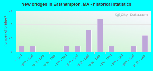
- New bridges - historical statistics
- 1Before 1900
- 11900-1909
- 11930-1939
- 11940-1949
- 41950-1959
- 61960-1969
- 11970-1979
- 11990-1999
- 32000-2009

- Reconstructed bridges - Historical Statistics
- 11950-1959
- 01960-1969
- 11970-1979
- 01980-1989
- 01990-1999
- 22000-2009


- Bridge Condition - Deck
- 5.3%Very good
- 31.6%Good
- 21.1%Satisfactory
- 36.8%Fair
- 5.3%Poor

- Bridge Condition - Superstructure
- 21.1%Very good
- 15.8%Good
- 31.6%Satisfactory
- 15.8%Fair
- 15.8%Poor

- Bridge Condition - Substructure
- 15.8%Very good
- 10.5%Good
- 36.8%Satisfactory
- 36.8%Fair

- Bridge Condition - Channel
- 7.1%Very good
- 50.0%Good
- 35.7%Satisfactory
- 7.1%Fair
Find on map >> Show street view
Structure Number: E050010LBMUNNBI, Location: .8 MI S OF RTE 10 (Lat: 42.279881, Lng: -72.654258), Route carried "on" structure: City street , Year Built: 1971, Status: Open, Structure Length: 4.33m (14.21ft), Average Daily Traffic: 9,310 (year 2019), Truck Traffic: 8%, Average Future Daily Traffic: 8,577 (year 2032), Design Load: H 20, Features Intersected: WATER MANHAN RIVER, Facility Carried by Structure: HWY LOVEFIELD ST
Minimum Vertical Clearance: 30+ m (98+ ft), Kilometerpoint: 0.048, Lanes on structure: 2, Owner: Town or Township Highway Agency, Approaching Roadway Width: 12.2m (40.0ft), Material/Design: Concrete continuous, Design/Construction: Slab, Number Of Spans In Main Unit: 7, Length of Maximum Span: 6.1m (20.0ft), Curb or Sidewalk Widths: Left: 0.5m (1.6ft), Right: 1.5m (4.9ft), Curb-To-Curb Width: 12.2m (40.0ft), Out-to-Out Width: 15.0m (49.2ft)
Condition: Deck: Good, Superstructure: Good, Substructure: Fair, Channel: Satisfactory, Operating Rating: 48.6 metric tons, Method Used To Determine Operating Rating: Allowable Stress (AS), Inventory Rating: 29.4 metric tons, Method Used To Determine Inventory Rating: Allowable Stress (AS), Structural Evaluation: Somewhat better than minimum adequacy, Deck Geometry: Somewhat better than minimum adequacy, Waterway Adequacy: Better than present minimum criteria, Approach Roadway Alignment: Better than present minimum criteria, Length Of Structure Improvement: 4.40m (14.44ft), Designated Inspection Frequency: Every 24 months, Underwater Inspection Frequency: Every 36 months, Inspection Date: January 2021, Underwater Inspection Date: December 2020, Bridge Improvement Cost: $2,593,000, Roadway Improvement Cost: $260,000, Total Project Cost: $3,890,000 ( Estimate for 2022), Deck Structure Type: Concrete Cast-file-Place, Wearing Surface/Protective System: Wearing Surface: Bituminous, Membrane: Built-up
Find on map >> Show street view
Structure Number: E050020LCMUNNBI, Location: 450' W OF ADAMS ST (Lat: 42.267878, Lng: -72.666781), Route carried "on" structure: City street , Year Built: 1956, Status: Open, Structure Length: 1.26m (4.13ft), Average Daily Traffic: 1,650 (year 2019), Truck Traffic: 4%, Average Future Daily Traffic: 3,677 (year 2032), Design Load: H 20, Features Intersected: WATER LOWER MILL POND, Facility Carried by Structure: HWY LIBERTY ST
Minimum Vertical Clearance: 30+ m (98+ ft), Kilometerpoint: 0.161, Lanes on structure: 2, Owner: Town or Township Highway Agency, Approaching Roadway Width: 7.9m (25.9ft), Material/Design: Prestressed concrete, Design/Construction: Slab, Number Of Spans In Main Unit: 1, Length of Maximum Span: 12.2m (40.0ft), Curb or Sidewalk Widths: Left: 0.3m (1.0ft), Right: 1.5m (4.9ft), Curb-To-Curb Width: 7.9m (25.9ft), Out-to-Out Width: 9.7m (31.8ft)
Condition: Deck: Poor, Superstructure: Poor, Substructure: Satisfactory, Channel: Good, Operating Rating: 56.9 metric tons, Method Used To Determine Operating Rating: Allowable Stress (AS), Inventory Rating: 42.9 metric tons, Method Used To Determine Inventory Rating: Allowable Stress (AS), Structural Evaluation: Meets minimum limits, Deck Geometry: Meets minimum limits, Waterway Adequacy: Better than present minimum criteria, Approach Roadway Alignment: Equal to present minimum criteria, Length Of Structure Improvement: 1.30m (4.27ft), Designated Inspection Frequency: Every 12 months, Underwater Inspection Frequency: Every 33 months, Other Special Inspection Frequency: Every 12 months, Inspection Date: January 2021, Underwater Inspection Date: June 2020, Other Special Inspection Date: January 2022, Bridge Improvement Cost: $498,000, Roadway Improvement Cost: $50,000, Total Project Cost: $748,000 ( Estimate for 2022), Deck Structure Type: Concrete Precast Panels, Wearing Surface/Protective System: Wearing Surface: Bituminous, Membrane: Built-up
Find on map >> Show street view
Structure Number: E050030L9MUNNBI, Location: 500 FT W OF ADAMS ST (Lat: 42.265239, Lng: -72.668286), Route carried "on" structure: State highway 141, Year Built: 1957, Status: Open, Structure Length: 1.26m (4.13ft), Average Daily Traffic: 21,466 (year 2016), Truck Traffic: 3%, Average Future Daily Traffic: 20,057 (year 2032), Design Load: H 20, Features Intersected: WATER NASHAWANNUCK POND
Minimum Vertical Clearance: 30+ m (98+ ft), Kilometerpoint: 0.386, Lanes on structure: 2, Base Highway Network: Yes, Owner: Town or Township Highway Agency, Approaching Roadway Width: 12.5m (41.0ft), Material/Design: Prestressed concrete, Design/Construction: Slab, Number Of Spans In Main Unit: 1, Length of Maximum Span: 12.2m (40.0ft), Curb or Sidewalk Widths: Left: 1.5m (4.9ft), Right: 2.7m (8.9ft), Curb-To-Curb Width: 12.8m (42.0ft), Out-to-Out Width: 17.1m (56.1ft)
Condition: Deck: Satisfactory, Superstructure: Satisfactory, Substructure: Satisfactory, Channel: Good, Operating Rating: 40.1 metric tons, Method Used To Determine Operating Rating: Allowable Stress (AS), Inventory Rating: 36.8 metric tons, Method Used To Determine Inventory Rating: Allowable Stress (AS), Structural Evaluation: Equal to present minimum criteria, Deck Geometry: Somewhat better than minimum adequacy, Waterway Adequacy: Better than present minimum criteria, Approach Roadway Alignment: Better than present minimum criteria, Length Of Structure Improvement: 1.30m (4.27ft), Designated Inspection Frequency: Every 24 months, Inspection Date: March 2021, Bridge Improvement Cost: $74,000, Roadway Improvement Cost: $8,000, Total Project Cost: $112,000 ( Estimate for 2022), Deck Structure Type: Concrete Precast Panels, Wearing Surface/Protective System: Wearing Surface: Bituminous, Membrane: Built-up
Find on map >> Show street view
Structure Number: E05004AKFDOTNBI, Location: .1 M N JCT EAST ST. (Lat: 42.288789, Lng: -72.617708), Route carried "on" structure: US 5, Year Built: 2004, Status: Open, Structure Length: 7.39m (24.25ft), Average Daily Traffic: 18,362 (year 2016), Truck Traffic: 10%, Average Future Daily Traffic: 13,266 (year 2031), Design Load: HS 25 or greater, Features Intersected: WATER MANHAN RIV OXBOW
Minimum Vertical Clearance: 30+ m (98+ ft), Kilometerpoint: 33.377, Lanes on structure: 2, Owner: State Highway Agency, Approaching Roadway Width: 12.5m (41.0ft), Material/Design: Steel continuous, Design/Construction: Stringer/Multi-beam, Number Of Spans In Main Unit: 3, Length of Maximum Span: 35.8m (117.5ft), Curb or Sidewalk Widths: Left: 1.8m (5.9ft), Right: 0.0m, Curb-To-Curb Width: 12.5m (41.0ft), Out-to-Out Width: 15.2m (49.9ft)
Condition: Deck: Good, Superstructure: Very good, Substructure: Very good, Channel: Very good, Operating Rating: 87.5 metric tons, Method Used To Determine Operating Rating: Load Factor (LF), Inventory Rating: 52.2 metric tons, Method Used To Determine Inventory Rating: Load Factor (LF), Structural Evaluation: Equal to present desirable criteria, Deck Geometry: Somewhat better than minimum adequacy, Waterway Adequacy: Meets minimum limits, Approach Roadway Alignment: Equal to present desirable criteria, Length Of Structure Improvement: 7.40m (24.28ft), Designated Inspection Frequency: Every 24 months, Underwater Inspection Frequency: Every 48 months, Inspection Date: October 2020, Underwater Inspection Date: January 2019, Bridge Improvement Cost: $628,000, Roadway Improvement Cost: $63,000, Total Project Cost: $943,000 ( Estimate for 2022), Deck Structure Type: Concrete Cast-file-Place, Wearing Surface/Protective System: Wearing Surface: Bituminous, Membrane: Preformed Fabric, Deck Protection: Epoxy Coated Reinforcing
Find on map >> Show street view
Structure Number: E050050LAMUNNBI, Location: .7 MI N OF RTE 10 (Lat: 42.266714, Lng: -72.691281), Route carried "on" structure: City street , Year Built: 1938, Status: Posted for load, Structure Length: 3.35m (10.99ft), Average Daily Traffic: 6,850 (year 2016), Truck Traffic: 6%, Average Future Daily Traffic: 9,476 (year 2032), Design Load: H 15, Features Intersected: WATER MANHAN RIVER, Facility Carried by Structure: HWY GLENDALE ST
Minimum Vertical Clearance: 30+ m (98+ ft), Kilometerpoint: 0.322, Lanes on structure: 2, Owner: Town or Township Highway Agency, Approaching Roadway Width: 6.7m (22.0ft), Skew: 1 degrees, Material/Design: Steel continuous, Design/Construction: Stringer/Multi-beam, Number Of Spans In Main Unit: 3, Length of Maximum Span: 18.9m (62.0ft), Curb or Sidewalk Widths: Left: 0.2m (0.7ft), Right: 0.2m (0.7ft), Curb-To-Curb Width: 7.3m (24.0ft), Out-to-Out Width: 8.4m (27.6ft)
Condition: Deck: Fair, Superstructure: Poor, Substructure: Fair, Channel: Good, Operating Rating: 75.1 metric tons, Method Used To Determine Operating Rating: Load Factor (LF), Inventory Rating: 45.0 metric tons, Method Used To Determine Inventory Rating: Load Factor (LF), Structural Evaluation: Meets minimum limits, Deck Geometry: High priority of replacement, Waterway Adequacy: Better than present minimum criteria, Approach Roadway Alignment: Meets minimum limits, Length Of Structure Improvement: 3.40m (11.15ft), Designated Inspection Frequency: Every 12 months, Other Special Inspection Frequency: Every 12 months, Inspection Date: September 2021, Other Special Inspection Date: September 2021, Bridge Improvement Cost: $1,122,000, Roadway Improvement Cost: $113,000, Total Project Cost: $1,684,000 ( Estimate for 2022), Deck Structure Type: Concrete Cast-file-Place, Wearing Surface/Protective System: Wearing Surface: Bituminous, Membrane: Other
Find on map >> Show street view
Structure Number: E050060V0DOTNBI, Location: 1.3 M S EASTHAMPTON T.L. (Lat: 42.273961, Lng: -72.673011), Route carried "on" structure: State highway 10, Year Built: 1951, Year Reconstructed: 2013, Status: Open, Structure Length: 2.98m (9.78ft), Average Daily Traffic: 31,100 (year 2019), Truck Traffic: 3%, Average Future Daily Traffic: 35,439 (year 2031), Design Load: HL 93, Features Intersected: WATER MANHAN RIVER
Minimum Vertical Clearance: 30+ m (98+ ft), Kilometerpoint: 36.853, Lanes on structure: 2, Base Highway Network: Yes, Owner: State Highway Agency, Approaching Roadway Width: 9.1m (29.9ft), Material/Design: Prestressed concrete, Design/Construction: Stringer/Multi-beam, Number Of Spans In Main Unit: 1, Length of Maximum Span: 28.3m (92.8ft), Curb or Sidewalk Widths: Left: 1.7m (5.6ft), Right: 1.7m (5.6ft), Curb-To-Curb Width: 9.1m (29.9ft), Out-to-Out Width: 13.3m (43.6ft)
Condition: Deck: Good, Superstructure: Good, Substructure: Good, Channel: Good, Operating Rating: 45.4 metric tons, Method Used To Determine Operating Rating: Load and Resistance Factor Rating (LRFR) rating reported by rating factor(RF) method using HL-93 loadings, Inventory Rating: 35.6 metric tons, Method Used To Determine Inventory Rating: Load and Resistance Factor Rating (LRFR) rating reported by rating factor(RF) method using HL-93 loadings, Structural Evaluation: Better than present minimum criteria, Deck Geometry: High priority of corrective action, Waterway Adequacy: Equal to present desirable criteria, Approach Roadway Alignment: Equal to present desirable criteria, Length Of Structure Improvement: 3.00m (9.84ft), Designated Inspection Frequency: Every 24 months, Inspection Date: October 2021, Bridge Improvement Cost: $1,217,000, Roadway Improvement Cost: $122,000, Total Project Cost: $1,826,000 ( Estimate for 2022), Deck Structure Type: Concrete Precast Panels, Wearing Surface/Protective System: Wearing Surface: Bituminous, Membrane: Preformed Fabric, Deck Protection: Epoxy Coated Reinforcing
Find on map >> Show street view
Structure Number: E050070LFMUNNBI, Location: JCT MINERAL STREET (Lat: 42.283514, Lng: -72.735803), Route carried "on" structure: City street , Year Built: 1992, Status: Open, Structure Length: 1.59m (5.22ft), Average Daily Traffic: 1,034 (year 2016), Truck Traffic: 6%, Average Future Daily Traffic: 407 (year 2033), Design Load: HS 20, Features Intersected: WATER N BR MANHAN RIVER, Facility Carried by Structure: HWY LOUDVILLE RD
Minimum Vertical Clearance: 30+ m (98+ ft), Kilometerpoint: 4.377, Lanes on structure: 2, Owner: Town or Township Highway Agency, Approaching Roadway Width: 9.8m (32.2ft), Skew: 4 degrees, Material/Design: Prestressed concrete, Design/Construction: Stringer/Multi-beam, Number Of Spans In Main Unit: 1, Length of Maximum Span: 15.2m (49.9ft), Curb or Sidewalk Widths: Left: 1.5m (4.9ft), Right: 0.2m (0.7ft), Curb-To-Curb Width: 9.8m (32.2ft), Out-to-Out Width: 12.3m (40.4ft)
Condition: Deck: Good, Superstructure: Good, Substructure: Satisfactory, Channel: Good, Operating Rating: 59.9 metric tons, Method Used To Determine Operating Rating: Allowable Stress (AS), Inventory Rating: 35.7 metric tons, Method Used To Determine Inventory Rating: Allowable Stress (AS), Structural Evaluation: Equal to present minimum criteria, Deck Geometry: Somewhat better than minimum adequacy, Waterway Adequacy: Equal to present desirable criteria, Approach Roadway Alignment: Equal to present desirable criteria, Length Of Structure Improvement: 1.60m (5.25ft), Designated Inspection Frequency: Every 24 months, Inspection Date: Febuary 2022, Bridge Improvement Cost: $544,000, Roadway Improvement Cost: $55,000, Total Project Cost: $817,000 ( Estimate for 2022), Deck Structure Type: Concrete Cast-file-Place, Wearing Surface/Protective System: Wearing Surface: Bituminous, Membrane: Preformed Fabric, Deck Protection: Epoxy Coated Reinforcing
Find on map >> Show street view
Structure Number: E05008140DOT634, Location: .5 M S JCT ST 10 (Lat: 42.262103, Lng: -72.677250), Route carried "on" structure: City street , Year Built: 1900, Year Reconstructed: 1955, Status: Posted for load, Structure Length: 1.23m (4.04ft), Average Daily Traffic: 13,488 (year 2015), Truck Traffic: 6%, Average Future Daily Traffic: 9,394 (year 2032), Features Intersected: OTHER MANHAN RAIL TRAIL, Facility Carried by Structure: HWY PARK ST
Minimum Vertical Clearance: 30+ m (98+ ft), Kilometerpoint: 0.000, Lanes on structure: 2, Owner: State Highway Agency, Approaching Roadway Width: 7.5m (24.6ft), Skew: 5 degrees, Material/Design: Steel, Design/Construction: Stringer/Multi-beam, Number Of Spans In Main Unit: 1, Length of Maximum Span: 8.5m (27.9ft), Curb or Sidewalk Widths: Left: 0.2m (0.7ft), Right: 1.5m (4.9ft), Curb-To-Curb Width: 7.3m (24.0ft), Out-to-Out Width: 9.6m (31.5ft)
Condition: Deck: Fair, Superstructure: Fair, Substructure: Fair, Operating Rating: 24.2 metric tons, Method Used To Determine Operating Rating: Load Factor (LF), Inventory Rating: 14.5 metric tons, Method Used To Determine Inventory Rating: Load Factor (LF), Structural Evaluation: High priority of corrective action, Deck Geometry: High priority of replacement, Approach Roadway Alignment: Meets minimum limits, Bridge Posting: Required (Relationship of Operating Rating to Maximum Legal Load: 20.0 - 29.9% below), Length Of Structure Improvement: 1.30m (4.27ft), Designated Inspection Frequency: Every 24 months, Inspection Date: August 2021, Bridge Improvement Cost: $491,000, Roadway Improvement Cost: $50,000, Total Project Cost: $737,000 ( Estimate for 2022), Deck Structure Type: Concrete Cast-file-Place, Wearing Surface/Protective System: Wearing Surface: Bituminous
Find on map >> Show street view
Structure Number: E050100L8MUNNBI, Location: AT SOUTHAMPTON LINE (Lat: 42.276475, Lng: -72.716436), Route carried "on" structure: City street , Year Built: 1940, Status: Posted for load, Structure Length: 2.78m (9.12ft), Average Daily Traffic: 2,200 (year 2019), Truck Traffic: 6%, Average Future Daily Traffic: 11,134 (year 2032), Features Intersected: WATER N BR MANHAN RIVER, Facility Carried by Structure: HWY TORREY ST
Minimum Vertical Clearance: 30+ m (98+ ft), Kilometerpoint: 0.016, Lanes on structure: 2, Owner: Town or Township Highway Agency, Approaching Roadway Width: 5.2m (17.1ft), Material/Design: Concrete continuous, Design/Construction: Slab, Number Of Spans In Main Unit: 3, Length of Maximum Span: 10.7m (35.1ft), Curb or Sidewalk Widths: Left: 0.2m (0.7ft), Right: 0.2m (0.7ft), Curb-To-Curb Width: 6.0m (19.7ft), Out-to-Out Width: 6.8m (22.3ft)
Condition: Deck: Satisfactory, Superstructure: Satisfactory, Substructure: Satisfactory, Channel: Satisfactory, Operating Rating: 39.1 metric tons, Method Used To Determine Operating Rating: Load Factor (LF), Inventory Rating: 23.4 metric tons, Method Used To Determine Inventory Rating: Load Factor (LF), Structural Evaluation: Equal to present minimum criteria, Deck Geometry: High priority of replacement, Waterway Adequacy: Better than present minimum criteria, Approach Roadway Alignment: High priority of corrective action, Length Of Structure Improvement: 2.80m (9.19ft), Designated Inspection Frequency: Every 24 months, Inspection Date: October 2021, Bridge Improvement Cost: $748,000, Roadway Improvement Cost: $75,000, Total Project Cost: $1,123,000 ( Estimate for 2022), Deck Structure Type: Concrete Cast-file-Place, Wearing Surface/Protective System: Wearing Surface: Bituminous
Find on map >> Show street view
Structure Number: E050110PRMUNNBI, Location: 1MI NW OF RT10 @SHMTN LIN (Lat: 42.266722, Lng: -72.697000), Route carried "on" structure: City street , Year Built: 1964, Status: Posted for load, Structure Length: 2.35m (7.71ft), Average Daily Traffic: 3,362 (year 2018), Truck Traffic: 6%, Average Future Daily Traffic: 3,880 (year 2031), Design Load: H 20, Features Intersected: WATER N BR MANHAN RIVER, Facility Carried by Structure: HWY PMROY MEADOW
Minimum Vertical Clearance: 30+ m (98+ ft), Kilometerpoint: 0.016, Lanes on structure: 2, Owner: Town or Township Highway Agency, Approaching Roadway Width: 9.1m (29.9ft), Material/Design: Concrete continuous, Design/Construction: Slab, Number Of Spans In Main Unit: 4, Length of Maximum Span: 5.7m (18.7ft), Curb or Sidewalk Widths: Left: 0.3m (1.0ft), Right: 0.3m (1.0ft), Curb-To-Curb Width: 9.1m (29.9ft), Out-to-Out Width: 10.5m (34.4ft)
Condition: Deck: Satisfactory, Superstructure: Satisfactory, Substructure: Fair, Channel: Fair, Operating Rating: 35.5 metric tons, Method Used To Determine Operating Rating: Allowable Stress (AS), Inventory Rating: 14.1 metric tons, Method Used To Determine Inventory Rating: Allowable Stress (AS), Structural Evaluation: Meets minimum limits, Deck Geometry: Meets minimum limits, Waterway Adequacy: Better than present minimum criteria, Approach Roadway Alignment: Better than present minimum criteria, Length Of Structure Improvement: 2.40m (7.87ft), Designated Inspection Frequency: Every 24 months, Inspection Date: December 2020, Bridge Improvement Cost: $990,000, Roadway Improvement Cost: $100,000, Total Project Cost: $1,486,000 ( Estimate for 2022), Deck Structure Type: Concrete Cast-file-Place, Wearing Surface/Protective System: Wearing Surface: Bituminous, Membrane: Built-up
Find on map >> Show street view
Structure Number: E050140LEMUNNBI, Location: .1 MI E OF PLEASANT ST (Lat: 42.275808, Lng: -72.654794), Route carried "on" structure: City street , Year Built: 1880, Year Reconstructed: 1984, Status: Open, Structure Length: 0.96m (3.15ft), Average Daily Traffic: 6,611 (year 2017), Truck Traffic: 4%, Average Future Daily Traffic: 8,986 (year 2032), Design Load: HS 20, Features Intersected: WATER LOWER MILL POND, Facility Carried by Structure: HWY FERRY ST
Minimum Vertical Clearance: 30+ m (98+ ft), Kilometerpoint: 0.225, Lanes on structure: 2, Owner: Town or Township Highway Agency, Approaching Roadway Width: 8.5m (27.9ft), Material/Design: Prestressed concrete, Design/Construction: Slab, Number Of Spans In Main Unit: 1, Length of Maximum Span: 9.1m (29.9ft), Curb or Sidewalk Widths: Left: 1.4m (4.6ft), Right: 0.1m (0.3ft), Curb-To-Curb Width: 8.5m (27.9ft), Out-to-Out Width: 11.0m (36.1ft)
Condition: Deck: Fair, Superstructure: Fair, Substructure: Satisfactory, Channel: Satisfactory, Operating Rating: 70.9 metric tons, Method Used To Determine Operating Rating: Load Factor (LF), Inventory Rating: 42.4 metric tons, Method Used To Determine Inventory Rating: Load Factor (LF), Structural Evaluation: Somewhat better than minimum adequacy, Deck Geometry: High priority of replacement, Waterway Adequacy: Better than present minimum criteria, Approach Roadway Alignment: Equal to present minimum criteria, Length Of Structure Improvement: 1.00m (3.28ft), Designated Inspection Frequency: Every 24 months, Inspection Date: Febuary 2021, Bridge Improvement Cost: $433,000, Roadway Improvement Cost: $44,000, Total Project Cost: $650,000 ( Estimate for 2022), Deck Structure Type: Concrete Precast Panels, Wearing Surface/Protective System: Wearing Surface: Bituminous, Membrane: Built-up
Find on map >> Show street view
Structure Number: E050150PQMUNNBI, Location: 0.4 MI N OF EAST STREET (Lat: 42.283511, Lng: -72.640503), Route carried "on" structure: City street , Year Built: 1964, Status: Open, Structure Length: 3.11m (10.20ft), Average Daily Traffic: 905 (year 2018), Truck Traffic: 6%, Average Future Daily Traffic: 816 (year 2031), Design Load: H 20, Features Intersected: WATER MANHAN RIVER, Facility Carried by Structure: HWY FORT HILL RD
Minimum Vertical Clearance: 30+ m (98+ ft), Kilometerpoint: 0.612, Lanes on structure: 2, Owner: Town or Township Highway Agency, Approaching Roadway Width: 9.9m (32.5ft), Skew: 1 degrees, Material/Design: Concrete continuous, Design/Construction: Slab, Number Of Spans In Main Unit: 5, Length of Maximum Span: 6.1m (20.0ft), Curb or Sidewalk Widths: Left: 0.3m (1.0ft), Right: 0.3m (1.0ft), Curb-To-Curb Width: 8.5m (27.9ft), Out-to-Out Width: 10.0m (32.8ft)
Condition: Deck: Satisfactory, Superstructure: Satisfactory, Substructure: Satisfactory, Channel: Satisfactory, Operating Rating: 43.1 metric tons, Method Used To Determine Operating Rating: Allowable Stress (AS), Inventory Rating: 24.8 metric tons, Method Used To Determine Inventory Rating: Allowable Stress (AS), Structural Evaluation: Equal to present minimum criteria, Deck Geometry: Somewhat better than minimum adequacy, Waterway Adequacy: Better than present minimum criteria, Approach Roadway Alignment: Better than present minimum criteria, Length Of Structure Improvement: 3.20m (10.50ft), Designated Inspection Frequency: Every 24 months, Underwater Inspection Frequency: Every 36 months, Inspection Date: December 2020, Underwater Inspection Date: January 2022, Bridge Improvement Cost: $1,257,000, Roadway Improvement Cost: $126,000, Total Project Cost: $1,886,000 ( Estimate for 2022), Deck Structure Type: Concrete Cast-file-Place, Wearing Surface/Protective System: Wearing Surface: Bituminous
Find on map >> Show street view
Structure Number: E050190LDMUNNBI, Location: .4 M SW OF RTE 141 (Lat: 42.243861, Lng: -72.657944), Route carried "on" structure: City street , Year Built: 1956, Year Reconstructed: 2011, Status: Open, Structure Length: 1.26m (4.13ft), Average Daily Traffic: 1,293 (year 2001), Truck Traffic: 6%, Average Future Daily Traffic: 2,042 (year 2032), Design Load: HS 25 or greater, Features Intersected: WATER BROAD BROOK, Facility Carried by Structure: HWY HENDRICK ST
Minimum Vertical Clearance: 30+ m (98+ ft), Kilometerpoint: 2.237, Lanes on structure: 2, Owner: Town or Township Highway Agency, Approaching Roadway Width: 7.9m (25.9ft), Material/Design: Prestressed concrete, Design/Construction: Slab, Number Of Spans In Main Unit: 1, Length of Maximum Span: 12.2m (40.0ft), Curb or Sidewalk Widths: Left: 1.5m (4.9ft), Right: 0.5m (1.6ft), Curb-To-Curb Width: 7.9m (25.9ft), Out-to-Out Width: 10.4m (34.1ft)
Condition: Deck: Very good, Superstructure: Very good, Substructure: Good, Channel: Satisfactory, Inventory Rating: 70.7 metric tons, Method Used To Determine Inventory Rating: Load Factor (LF), Structural Evaluation: Better than present minimum criteria, Deck Geometry: Meets minimum limits, Waterway Adequacy: Better than present minimum criteria, Approach Roadway Alignment: Equal to present minimum criteria, Length Of Structure Improvement: 1.30m (4.27ft), Designated Inspection Frequency: Every 24 months, Inspection Date: July 2021, Bridge Improvement Cost: $675,000, Roadway Improvement Cost: $68,000, Total Project Cost: $1,013,000 ( Estimate for 2022), Deck Structure Type: Concrete Cast-file-Place, Wearing Surface/Protective System: Wearing Surface: Bituminous, Membrane: Preformed Fabric, Deck Protection: Epoxy Coated Reinforcing
Find on map >> Show street view
Structure Number: E05024B2ADOTNBI, Location: MM 21.0 ON I-91 SB (Lat: 42.286194, Lng: -72.620106), Route carried "on" structure: Interstate 91, Year Built: 2009, Status: Open, Structure Length: 8.58m (28.15ft), Average Daily Traffic: 27,526 (year 2017), Truck Traffic: 6%, Average Future Daily Traffic: 102,654 (year 2031), Design Load: HS 25 or greater, Features Intersected: HWY EAST ST
Minimum Vertical Clearance: 30+ m (98+ ft), Kilometerpoint: 33.956, Lanes on structure: 2, Lanes under structure: 2, Base Highway Network: Yes, Owner: State Highway Agency, Approaching Roadway Width: 11.6m (38.1ft), Skew: 5 degrees, Material/Design: Steel continuous, Design/Construction: Stringer/Multi-beam, Number Of Spans In Main Unit: 3, Length of Maximum Span: 31.3m (102.7ft), Curb-To-Curb Width: 11.6m (38.1ft), Out-to-Out Width: 12.7m (41.7ft)
Condition: Deck: Good, Superstructure: Very good, Substructure: Very good, Operating Rating: 91.7 metric tons, Method Used To Determine Operating Rating: Load Factor (LF), Inventory Rating: 54.8 metric tons, Method Used To Determine Inventory Rating: Load Factor (LF), Structural Evaluation: Equal to present desirable criteria, Deck Geometry: Equal to present minimum criteria, Underclear: Meets minimum limits, Approach Roadway Alignment: Equal to present desirable criteria, Length Of Structure Improvement: 8.60m (28.22ft), Designated Inspection Frequency: Every 24 months, Inspection Date: August 2020, Bridge Improvement Cost: $974,000, Roadway Improvement Cost: $98,000, Total Project Cost: $1,462,000 ( Estimate for 2022), Deck Structure Type: Concrete Cast-file-Place, Wearing Surface/Protective System: Wearing Surface: Bituminous, Membrane: Preformed Fabric, Deck Protection: Epoxy Coated Reinforcing
Find on map >> Show street view
Structure Number: E05024B2BDOTNBI, Location: MM 21.0 ON I-91 SB (Lat: 42.286186, Lng: -72.619317), Route carried "on" structure: Interstate 91, Year Built: 2009, Status: Open, Structure Length: 7.61m (24.97ft), Average Daily Traffic: 27,714 (year 2017), Truck Traffic: 6%, Average Future Daily Traffic: 102,654 (year 2031), Design Load: HS 25 or greater, Features Intersected: HWY EAST ST
Minimum Vertical Clearance: 30+ m (98+ ft), Kilometerpoint: 33.956, Lanes on structure: 2, Lanes under structure: 2, Base Highway Network: Yes, Owner: State Highway Agency, Approaching Roadway Width: 11.6m (38.1ft), Skew: 5 degrees, Material/Design: Steel continuous, Design/Construction: Stringer/Multi-beam, Number Of Spans In Main Unit: 3, Length of Maximum Span: 31.3m (102.7ft), Curb-To-Curb Width: 11.6m (38.1ft), Out-to-Out Width: 12.7m (41.7ft)
Condition: Deck: Good, Superstructure: Very good, Substructure: Very good, Operating Rating: 91.7 metric tons, Method Used To Determine Operating Rating: Load Factor (LF), Inventory Rating: 54.8 metric tons, Method Used To Determine Inventory Rating: Load Factor (LF), Structural Evaluation: Equal to present desirable criteria, Deck Geometry: Equal to present minimum criteria, Underclear: Meets minimum limits, Approach Roadway Alignment: Equal to present desirable criteria, Length Of Structure Improvement: 7.70m (25.26ft), Designated Inspection Frequency: Every 24 months, Inspection Date: August 2020, Bridge Improvement Cost: $872,000, Roadway Improvement Cost: $88,000, Total Project Cost: $1,309,000 ( Estimate for 2022), Deck Structure Type: Concrete Cast-file-Place, Wearing Surface/Protective System: Wearing Surface: Bituminous, Membrane: Preformed Fabric, Deck Protection: Epoxy Coated Reinforcing
Find on map >> Show street view
Structure Number: E050250X9DOTNBI, Location: MM 21.2 ON I-91 SB (Lat: 42.287092, Lng: -72.621997), Route carried "on" structure: Interstate 91, Year Built: 1963, Status: Temporarily open, Structure Length: 5.54m (18.18ft), Average Daily Traffic: 27,526 (year 2017), Truck Traffic: 6%, Average Future Daily Traffic: 81,334 (year 2033), Design Load: HS 20+Mod, Features Intersected: OTHER MANHAN RAIL TRAIL
Minimum Vertical Clearance: 30+ m (98+ ft), Kilometerpoint: 34.117, Lanes on structure: 2, Base Highway Network: Yes, Owner: State Highway Agency, Approaching Roadway Width: 11.6m (38.1ft), Skew: 5 degrees, Material/Design: Steel, Design/Construction: Stringer/Multi-beam, Number Of Spans In Main Unit: 3, Length of Maximum Span: 17.9m (58.7ft), Curb or Sidewalk Widths: Left: 0.5m (1.6ft), Right: 0.5m (1.6ft), Curb-To-Curb Width: 11.6m (38.1ft), Out-to-Out Width: 13.5m (44.3ft)
Condition: Deck: Fair, Superstructure: Fair, Substructure: Satisfactory, Operating Rating: 56.0 metric tons, Method Used To Determine Operating Rating: Load Factor (LF), Inventory Rating: 33.5 metric tons, Method Used To Determine Inventory Rating: Load Factor (LF), Structural Evaluation: Somewhat better than minimum adequacy, Deck Geometry: Equal to present minimum criteria, Approach Roadway Alignment: Equal to present desirable criteria, Length Of Structure Improvement: 5.60m (18.37ft), Designated Inspection Frequency: Every 24 months, Inspection Date: March 2020, Bridge Improvement Cost: $2,970,000, Roadway Improvement Cost: $298,000, Total Project Cost: $4,456,000 ( Estimate for 2022), Deck Structure Type: Concrete Cast-file-Place, Wearing Surface/Protective System: Wearing Surface: Bituminous, Membrane: Built-up
Find on map >> Show street view
Structure Number: E050250XADOTNBI, Location: MM 21.2 ON I-91 NB (Lat: 42.287089, Lng: -72.621250), Route carried "on" structure: Interstate 91, Year Built: 1963, Status: Open, Structure Length: 6.28m (20.60ft), Average Daily Traffic: 27,714 (year 2017), Truck Traffic: 6%, Average Future Daily Traffic: 39,956 (year 2033), Design Load: HS 20+Mod, Features Intersected: OTHER MANHAN RAIL TRAIL
Minimum Vertical Clearance: 30+ m (98+ ft), Kilometerpoint: 34.117, Lanes on structure: 2, Base Highway Network: Yes, Owner: State Highway Agency, Approaching Roadway Width: 11.6m (38.1ft), Skew: 5 degrees, Material/Design: Steel, Design/Construction: Stringer/Multi-beam, Number Of Spans In Main Unit: 3, Length of Maximum Span: 20.3m (66.6ft), Curb or Sidewalk Widths: Left: 0.5m (1.6ft), Right: 0.5m (1.6ft), Curb-To-Curb Width: 11.6m (38.1ft), Out-to-Out Width: 13.5m (44.3ft)
Condition: Deck: Fair, Superstructure: Poor, Substructure: Fair, Operating Rating: 39.9 metric tons, Method Used To Determine Operating Rating: Load Factor (LF), Inventory Rating: 20.7 metric tons, Method Used To Determine Inventory Rating: Load Factor (LF), Structural Evaluation: Meets minimum limits, Deck Geometry: Equal to present minimum criteria, Approach Roadway Alignment: Equal to present desirable criteria, Length Of Structure Improvement: 7.40m (24.28ft), Designated Inspection Frequency: Every 12 months, Other Special Inspection Frequency: Every 12 months, Inspection Date: March 2020, Other Special Inspection Date: March 2021, Bridge Improvement Cost: $5,698,000, Roadway Improvement Cost: $570,000, Total Project Cost: $8,548,000 ( Estimate for 2022), Deck Structure Type: Concrete Cast-file-Place, Wearing Surface/Protective System: Wearing Surface: Bituminous, Membrane: Built-up
Find on map >> Show street view
Structure Number: E050260XBDOTNBI, Location: MM 21.1 ON I-91 SB (Lat: 42.287878, Lng: -72.623378), Route carried "on" structure: Interstate 91, Year Built: 1963, Status: Open, Structure Length: 6.27m (20.57ft), Average Daily Traffic: 27,526 (year 2017), Truck Traffic: 6%, Average Future Daily Traffic: 39,956 (year 2032), Design Load: HS 20+Mod, Features Intersected: WATER MANHAN RIV OXBOW
Minimum Vertical Clearance: 30+ m (98+ ft), Kilometerpoint: 34.206, Lanes on structure: 2, Base Highway Network: Yes, Owner: State Highway Agency, Approaching Roadway Width: 11.6m (38.1ft), Skew: 2 degrees, Material/Design: Steel, Design/Construction: Stringer/Multi-beam, Number Of Spans In Main Unit: 3, Length of Maximum Span: 42.3m (138.8ft), Curb or Sidewalk Widths: Left: 0.5m (1.6ft), Right: 0.5m (1.6ft), Curb-To-Curb Width: 11.6m (38.1ft), Out-to-Out Width: 13.5m (44.3ft)
Condition: Deck: Fair, Superstructure: Satisfactory, Substructure: Fair, Channel: Good, Operating Rating: 54.4 metric tons, Method Used To Determine Operating Rating: Allowable Stress (AS), Inventory Rating: 27.6 metric tons, Method Used To Determine Inventory Rating: Allowable Stress (AS), Structural Evaluation: Somewhat better than minimum adequacy, Deck Geometry: Equal to present minimum criteria, Waterway Adequacy: Equal to present desirable criteria, Approach Roadway Alignment: Equal to present desirable criteria, Length Of Structure Improvement: 6.30m (20.67ft), Designated Inspection Frequency: Every 24 months, Inspection Date: July 2020, Bridge Improvement Cost: $3,341,000, Roadway Improvement Cost: $335,000, Total Project Cost: $5,012,000 ( Estimate for 2022), Deck Structure Type: Concrete Cast-file-Place, Wearing Surface/Protective System: Wearing Surface: Bituminous, Membrane: Built-up
Find on map >> Show street view
Structure Number: E050260XCDOTNBI, Location: MM 21.1 ON I-91 NB (Lat: 42.288033, Lng: -72.622992), Route carried "on" structure: Interstate 91, Year Built: 1963, Status: Open, Structure Length: 6.24m (20.47ft), Average Daily Traffic: 27,714 (year 2017), Truck Traffic: 6%, Average Future Daily Traffic: 42,483 (year 2031), Design Load: HS 20+Mod, Features Intersected: WATER MANHAN RIV OXBOW
Minimum Vertical Clearance: 30+ m (98+ ft), Kilometerpoint: 34.206, Lanes on structure: 2, Base Highway Network: Yes, Owner: State Highway Agency, Approaching Roadway Width: 11.6m (38.1ft), Skew: 2 degrees, Material/Design: Steel, Design/Construction: Stringer/Multi-beam, Number Of Spans In Main Unit: 3, Length of Maximum Span: 42.7m (140.1ft), Curb-To-Curb Width: 11.6m (38.1ft), Out-to-Out Width: 13.5m (44.3ft)
Condition: Deck: Fair, Superstructure: Satisfactory, Substructure: Fair, Channel: Good, Operating Rating: 54.4 metric tons, Method Used To Determine Operating Rating: Allowable Stress (AS), Inventory Rating: 27.6 metric tons, Method Used To Determine Inventory Rating: Allowable Stress (AS), Structural Evaluation: Somewhat better than minimum adequacy, Deck Geometry: Equal to present minimum criteria, Waterway Adequacy: Equal to present desirable criteria, Approach Roadway Alignment: Equal to present desirable criteria, Length Of Structure Improvement: 6.30m (20.67ft), Designated Inspection Frequency: Every 24 months, Inspection Date: July 2020, Bridge Improvement Cost: $3,341,000, Roadway Improvement Cost: $335,000, Total Project Cost: $5,012,000 ( Estimate for 2022), Deck Structure Type: Concrete Cast-file-Place, Wearing Surface/Protective System: Wearing Surface: Bituminous, Membrane: Built-up