Bridge Statistics for East Lansing, Michigan (MI)
Condition, Traffic, Stress, Structural Evaluation, Project Costs
- National Bridge Inventory (NBI) Statistics
- 50Number of bridges
- 489ft / 149mTotal length
- 956,323Total average daily traffic
- 66,630Total average daily truck traffic
- National Bridge Inventory (NBI) Registered Bridges for East Lansing
- No street view available for this location
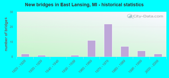
- New bridges - historical statistics
- 21920-1929
- 11930-1939
- 11950-1959
- 111960-1969
- 221970-1979
- 71980-1989
- 41990-1999
- 22000-2009

- Reconstructed bridges - Historical Statistics
- 11980-1989
- 31990-1999
- 12000-2009


- Bridge Condition - Deck
- 13.6%Good
- 36.4%Satisfactory
- 36.4%Fair
- 9.1%Poor
- 4.5%Serious

- Bridge Condition - Superstructure
- 13.6%Good
- 27.3%Satisfactory
- 36.4%Fair
- 9.1%Poor
- 13.6%Serious

- Bridge Condition - Substructure
- 31.8%Good
- 27.3%Satisfactory
- 36.4%Fair
- 4.5%Poor

- Bridge Condition - Channel
- 81.8%Satisfactory
- 18.2%Fair
Find on map >> Show street view
Structure Number: 376, Location: 2.0 MI W OF STANDISH (Lat: 43.983064, Lng: -83.997789), Route carried "on" structure: State highway 61, Year Built: 1952, Status: Open, Structure Length: 0.73m (2.40ft), Average Daily Traffic: 4,242 (year 2007), Truck Traffic: 7%, Average Future Daily Traffic: 4,845 (year 2018), Design Load: HS 20, Features Intersected: M BR PINE RIVER
Minimum Vertical Clearance: 30.48m (100.00ft), Kilometerpoint: 3.819, Lanes on structure: 2, Base Highway Network: Yes (Inventory Route: 106, Subroute: 1), Owner: State Highway Agency, Approaching Roadway Width: 12.8m (42.0ft), Material/Design: Concrete, Design/Construction: Slab, Number Of Spans In Main Unit: 1, Length of Maximum Span: 7.3m (24.0ft), Curb or Sidewalk Widths: Left: 0.4m (1.3ft), Right: 0.4m (1.3ft), Curb-To-Curb Width: 11.5m (37.7ft), Out-to-Out Width: 13.2m (43.3ft)
Condition: Deck: Fair, Superstructure: Fair, Substructure: Good, Channel: Satisfactory, Operating Rating: 63.7 metric tons, Method Used To Determine Operating Rating: Load Factor (LF), Inventory Rating: 38.1 metric tons, Method Used To Determine Inventory Rating: Load Factor (LF), Structural Evaluation: Somewhat better than minimum adequacy, Deck Geometry: Somewhat better than minimum adequacy, Waterway Adequacy: Equal to present minimum criteria, Approach Roadway Alignment: Equal to present desirable criteria, Designated Inspection Frequency: Every 24 months, Inspection Date: May 2020, Deck Structure Type: Concrete Cast-file-Place, Wearing Surface/Protective System: Wearing Surface: Bituminous
Find on map >> Show street view
Structure Number: 1819, Location: 0.4 MI N OF I-69 (Lat: 42.813064, Lng: -84.511014), Route carried "on" structure: County highway , Year Built: 1994, Status: Open, Structure Length: 14.69m (48.20ft), Average Daily Traffic: 7,500 (year 1994), Truck Traffic: 5%, Average Future Daily Traffic: 7,500 (year 2014), Design Load: HS 25 or greater, Features Intersected: US-127 & I-69 C-D/RAMPS, Facility Carried by Structure: CLARK ROAD
Minimum Vertical Clearance: 30.48m (100.00ft), Kilometerpoint: 22.673, Lanes on structure: 2, Lanes under structure: 8, Owner: State Highway Agency, Approaching Roadway Width: 14.5m (47.6ft), Material/Design: Prestressed concrete, Design/Construction: Stringer/Multi-beam, Number Of Spans In Main Unit: 6, Length of Maximum Span: 32.0m (105.0ft), Curb-To-Curb Width: 14.6m (47.9ft), Out-to-Out Width: 15.6m (51.2ft)
Condition: Deck: Good, Superstructure: Satisfactory, Substructure: Good, Operating Rating: 66.4 metric tons, Method Used To Determine Operating Rating: Load Factor (LF) rating reported by rating factor (RF) method using MS18 loading, Inventory Rating: 40.8 metric tons, Method Used To Determine Inventory Rating: Load Factor (LF) rating reported by rating factor (RF) method using MS18 loading, Structural Evaluation: Equal to present minimum criteria, Deck Geometry: Superior to present desirable criteria, Underclear: Superior to present desirable criteria, Approach Roadway Alignment: Equal to present desirable criteria, Designated Inspection Frequency: Every 24 months, Inspection Date: May 2020, Deck Structure Type: Concrete Cast-file-Place, Wearing Surface/Protective System: Wearing Surface: Epoxy Overlay, Deck Protection: Epoxy Coated Reinforcing
Find on map >> Show street view
Structure Number: 1849, Location: 2.6 MI N OF EAST LANSING (Lat: 42.807117, Lng: -84.511106), Route carried "on" structure: Ramp Interstate 69, Year Built: 1985, Status: Open, Structure Length: 17.22m (56.50ft), Average Daily Traffic: 8,647 (year 2010), Truck Traffic: 11%, Average Future Daily Traffic: 9,522 (year 2020), Design Load: HS 25 or greater, Features Intersected: US-127, SB&NB US-127 C-D
Minimum Vertical Clearance: 30.48m (100.00ft), Kilometerpoint: 1.115, Lanes on structure: 2, Lanes under structure: 8, Owner: State Highway Agency, Approaching Roadway Width: 12.2m (40.0ft), Skew: 3 degrees, Material/Design: Steel continuous, Design/Construction: Stringer/Multi-beam, Number Of Spans In Main Unit: 4, Length of Maximum Span: 45.7m (149.9ft), Curb-To-Curb Width: 12.2m (40.0ft), Out-to-Out Width: 13.2m (43.3ft)
Condition: Deck: Satisfactory, Superstructure: Satisfactory, Substructure: Good, Operating Rating: 81.3 metric tons, Method Used To Determine Operating Rating: Load Factor (LF) rating reported by rating factor (RF) method using MS18 loading, Inventory Rating: 48.6 metric tons, Method Used To Determine Inventory Rating: Load Factor (LF) rating reported by rating factor (RF) method using MS18 loading, Structural Evaluation: Equal to present minimum criteria, Deck Geometry: Superior to present desirable criteria, Underclear: High priority of corrective action, Approach Roadway Alignment: Equal to present desirable criteria, Designated Inspection Frequency: Every 24 months, Inspection Date: May 2020, Deck Structure Type: Concrete Cast-file-Place, Wearing Surface/Protective System: Wearing Surface: Latex Concrete, Deck Protection: Epoxy Coated Reinforcing
Find on map >> Show street view
Structure Number: 1858, Location: 0.2 MILES NORTH OF CLARK (Lat: 42.815375, Lng: -84.519914), Route carried "on" structure: Interstate 69, Year Built: 1973, Status: Open, Structure Length: 0.73m (2.40ft), Average Daily Traffic: 37,978 (year 2007), Truck Traffic: 16%, Average Future Daily Traffic: 49,205 (year 2018), Design Load: HS 20+Mod, Features Intersected: CHANDLER DRAIN
Minimum Vertical Clearance: 30.48m (100.00ft), Kilometerpoint: 14.217, Lanes on structure: 8, Base Highway Network: Yes (Inventory Route: 36, Subroute: 5), Owner: State Highway Agency, Approaching Roadway Width: 38.1m (125.0ft), Material/Design: Steel, Design/Construction: Culvert, Number Of Spans In Main Unit: 2, Length of Maximum Span: 3.6m (11.8ft)
Condition: Channel: Fair, Culverts: Satisfactory, Operating Rating: 97.2 metric tons, Method Used To Determine Operating Rating: Load Factor (LF) rating reported by rating factor (RF) method using MS18 loading, Inventory Rating: 97.2 metric tons, Method Used To Determine Inventory Rating: Load Factor (LF) rating reported by rating factor (RF) method using MS18 loading, Structural Evaluation: Equal to present minimum criteria, Waterway Adequacy: Equal to present minimum criteria, Approach Roadway Alignment: Equal to present desirable criteria, Designated Inspection Frequency: Every 24 months, Inspection Date: April 2020
Find on map >> Show street view
Structure Number: 1893, Location: 0.2 MI N OF INGHAM COL (Lat: 42.772186, Lng: -84.513314), Route carried "on" structure: US 127, Year Built: 1971, Status: Open, Structure Length: 4.63m (15.19ft), Average Daily Traffic: 41,300 (year 2012), Truck Traffic: 5%, Average Future Daily Traffic: 43,325 (year 2032), Design Load: HS 20, Features Intersected: COLEMAN RD
Minimum Vertical Clearance: 30.48m (100.00ft), Kilometerpoint: 0.285, Lanes on structure: 2, Lanes under structure: 2, Base Highway Network: Yes (Inventory Route: 36, Subroute: 10), Owner: State Highway Agency, Approaching Roadway Width: 13.7m (44.9ft), Skew: 2 degrees, Material/Design: Steel, Design/Construction: Stringer/Multi-beam, Number Of Spans In Main Unit: 3, Length of Maximum Span: 16.7m (54.8ft), Curb-To-Curb Width: 12.3m (40.4ft), Out-to-Out Width: 13.4m (44.0ft)
Condition: Deck: Satisfactory, Superstructure: Satisfactory, Substructure: Good, Operating Rating: 64.8 metric tons, Method Used To Determine Operating Rating: Load Factor (LF) rating reported by rating factor (RF) method using MS18 loading, Inventory Rating: 38.6 metric tons, Method Used To Determine Inventory Rating: Load Factor (LF) rating reported by rating factor (RF) method using MS18 loading, Structural Evaluation: Equal to present minimum criteria, Deck Geometry: Better than present minimum criteria, Underclear: Meets minimum limits, Approach Roadway Alignment: Equal to present desirable criteria, Designated Inspection Frequency: Every 24 months, Inspection Date: September 2020, Deck Structure Type: Concrete Cast-file-Place, Wearing Surface/Protective System: Wearing Surface: Epoxy Overlay
Find on map >> Show street view
Structure Number: 1894, Location: 1 MI N OF INGHAM CO LINE (Lat: 42.784108, Lng: -84.513592), Route carried "on" structure: County highway , Year Built: 1971, Status: Open, Structure Length: 8.23m (27.00ft), Average Daily Traffic: 3,300 (year 0000), Truck Traffic: 3%, Average Future Daily Traffic: 3,300 (year 2015), Design Load: H 20, Features Intersected: US-127, Facility Carried by Structure: STATE RD
Minimum Vertical Clearance: 30.48m (100.00ft), Kilometerpoint: 4.563, Lanes on structure: 2, Lanes under structure: 4, Owner: State Highway Agency, Approaching Roadway Width: 10.9m (35.8ft), Material/Design: Steel, Design/Construction: Stringer/Multi-beam, Number Of Spans In Main Unit: 2, Length of Maximum Span: 42.6m (139.8ft), Curb-To-Curb Width: 10.5m (34.4ft), Out-to-Out Width: 11.7m (38.4ft)
Condition: Deck: Satisfactory, Superstructure: Satisfactory, Substructure: Satisfactory, Operating Rating: 70.0 metric tons, Method Used To Determine Operating Rating: Load Factor (LF) rating reported by rating factor (RF) method using MS18 loading, Inventory Rating: 41.8 metric tons, Method Used To Determine Inventory Rating: Load Factor (LF) rating reported by rating factor (RF) method using MS18 loading, Structural Evaluation: Equal to present minimum criteria, Deck Geometry: Somewhat better than minimum adequacy, Underclear: Equal to present minimum criteria, Approach Roadway Alignment: Equal to present desirable criteria, Designated Inspection Frequency: Every 24 months, Inspection Date: September 2020, Deck Structure Type: Concrete Cast-file-Place, Wearing Surface/Protective System: Wearing Surface: Epoxy Overlay
Find on map >> Show street view
Structure Number: 1896, Location: 0.75 MI W OF CHANDLER RD (Lat: 42.813042, Lng: -84.500392), Route carried "on" structure: County highway 1912, Year Built: 1963, Status: Open, Structure Length: 1.55m (5.09ft), Average Daily Traffic: 4,198 (year 2011), Truck Traffic: 2%, Average Future Daily Traffic: 7,582 (year 2031), Design Load: HS 20, Features Intersected: BR OF LOOKING GLASS RIVR, Facility Carried by Structure: CLARK RD
Minimum Vertical Clearance: 30.48m (100.00ft), Kilometerpoint: 23.568, Lanes on structure: 2, Owner: County Highway Agency, Approaching Roadway Width: 10.4m (34.1ft), Material/Design: Prestressed concrete, Design/Construction: Box Beam or Girders - Multiple, Number Of Spans In Main Unit: 1, Length of Maximum Span: 15.2m (49.9ft), Curb-To-Curb Width: 8.8m (28.9ft), Out-to-Out Width: 10.3m (33.8ft)
Condition: Deck: Serious, Superstructure: Serious, Substructure: Good, Channel: Satisfactory, Operating Rating: 45.1 metric tons, Method Used To Determine Operating Rating: Load Factor (LF), Inventory Rating: 27.1 metric tons, Method Used To Determine Inventory Rating: Load Factor (LF), Structural Evaluation: High priority of corrective action, Deck Geometry: Meets minimum limits, Waterway Adequacy: Better than present minimum criteria, Approach Roadway Alignment: Equal to present desirable criteria, Designated Inspection Frequency: Every 12 months, Inspection Date: October 2021, Deck Structure Type: Other, Wearing Surface/Protective System: Wearing Surface: Bituminous
Find on map >> Show street view
Structure Number: 3752, Location: W LTS OF E LANSING (Lat: 42.724022, Lng: -84.512708), Route carried "on" structure: Interstate 496, Year Built: 1970, Status: Open, Structure Length: 13.59m (44.59ft), Average Daily Traffic: 34,831 (year 2015), Truck Traffic: 7%, Average Future Daily Traffic: 34,732 (year 2018), Design Load: HS 20+Mod, Features Intersected: RED CEDAR RIVER & RAMP V
Minimum Vertical Clearance: 30.48m (100.00ft), Kilometerpoint: 7.448, Lanes on structure: 3, Lanes under structure: 1, Base Highway Network: Yes (Inventory Route: 35, Subroute: 10), Owner: State Highway Agency, Approaching Roadway Width: 16.1m (52.8ft), Skew: 4 degrees, Material/Design: Steel, Design/Construction: Stringer/Multi-beam, Number Of Spans In Main Unit: 5, Length of Maximum Span: 42.6m (139.8ft), Curb or Sidewalk Widths: Left: 0.2m (0.7ft), Right: 0.2m (0.7ft), Curb-To-Curb Width: 14.6m (47.9ft), Out-to-Out Width: 15.3m (50.2ft)
Condition: Deck: Poor, Superstructure: Satisfactory, Substructure: Satisfactory, Channel: Satisfactory, Operating Rating: 59.0 metric tons, Method Used To Determine Operating Rating: Load Factor (LF) rating reported by rating factor (RF) method using MS18 loading, Inventory Rating: 35.3 metric tons, Method Used To Determine Inventory Rating: Load Factor (LF) rating reported by rating factor (RF) method using MS18 loading, Structural Evaluation: Equal to present minimum criteria, Deck Geometry: Meets minimum limits, Underclear: Meets minimum limits, Waterway Adequacy: Equal to present desirable criteria, Approach Roadway Alignment: Equal to present desirable criteria, Designated Inspection Frequency: Every 24 months, Other Special Inspection Frequency: Every 24 months, Inspection Date: October 2021, Other Special Inspection Date: October 2020, Bridge Improvement Cost: $2,867,000, Deck Structure Type: Concrete Cast-file-Place, Wearing Surface/Protective System: Wearing Surface: Latex Concrete
Find on map >> Show street view
Structure Number: 3753, Location: W LTS OF E LANSING (Lat: 42.724292, Lng: -84.512342), Route carried "on" structure: Interstate 496, Year Built: 1970, Year Reconstructed: 1994, Status: Open, Structure Length: 12.61m (41.37ft), Average Daily Traffic: 34,831 (year 2015), Truck Traffic: 7%, Average Future Daily Traffic: 34,732 (year 2018), Design Load: HS 25 or greater, Features Intersected: RED CEDAR RIVER & RAMP V
Minimum Vertical Clearance: 30.48m (100.00ft), Kilometerpoint: 7.487, Lanes on structure: 2, Lanes under structure: 1, Base Highway Network: Yes (Inventory Route: 35, Subroute: 1), Owner: State Highway Agency, Approaching Roadway Width: 16.7m (54.8ft), Skew: 4 degrees, Material/Design: Steel, Design/Construction: Stringer/Multi-beam, Number Of Spans In Main Unit: 4, Length of Maximum Span: 42.7m (140.1ft), Curb-To-Curb Width: 17.7m (58.1ft), Out-to-Out Width: 18.7m (61.4ft)
Condition: Deck: Satisfactory, Superstructure: Poor, Substructure: Fair, Channel: Satisfactory, Operating Rating: 73.9 metric tons, Method Used To Determine Operating Rating: Load Factor (LF) rating reported by rating factor (RF) method using MS18 loading, Inventory Rating: 44.1 metric tons, Method Used To Determine Inventory Rating: Load Factor (LF) rating reported by rating factor (RF) method using MS18 loading, Structural Evaluation: Meets minimum limits, Deck Geometry: Superior to present desirable criteria, Underclear: Meets minimum limits, Waterway Adequacy: Better than present minimum criteria, Approach Roadway Alignment: Equal to present desirable criteria, Designated Inspection Frequency: Every 12 months, Inspection Date: October 2021, Bridge Improvement Cost: $1,885,000, Deck Structure Type: Concrete Cast-file-Place, Wearing Surface/Protective System: Wearing Surface: Monolithic Concrete, Deck Protection: Epoxy Coated Reinforcing
Find on map >> Show street view
Structure Number: 3757, Location: IN EAST LANSING (Lat: 42.720203, Lng: -84.504767), Route carried "on" structure: Interstate 496, Year Built: 1963, Status: Open, Structure Length: 9.30m (30.51ft), Average Daily Traffic: 34,668 (year 2015), Truck Traffic: 7%, Average Future Daily Traffic: 34,953 (year 2018), Design Load: HS 20+Mod, Features Intersected: CSX RR & TROWBRIDGE RMP
Minimum Vertical Clearance: 30.48m (100.00ft), Kilometerpoint: 8.348, Lanes on structure: 3, Lanes under structure: 3, Base Highway Network: Yes (Inventory Route: 35, Subroute: 10), Owner: State Highway Agency, Approaching Roadway Width: 15.2m (49.9ft), Skew: 2 degrees, Material/Design: Steel, Design/Construction: Stringer/Multi-beam, Number Of Spans In Main Unit: 3, Length of Maximum Span: 35.7m (117.1ft), Curb or Sidewalk Widths: Left: 0.2m (0.7ft), Right: 0.2m (0.7ft), Curb-To-Curb Width: 14.0m (45.9ft), Out-to-Out Width: 14.7m (48.2ft)
Condition: Deck: Fair, Superstructure: Poor, Substructure: Fair, Operating Rating: 60.6 metric tons, Method Used To Determine Operating Rating: Load Factor (LF) rating reported by rating factor (RF) method using MS18 loading, Inventory Rating: 36.3 metric tons, Method Used To Determine Inventory Rating: Load Factor (LF) rating reported by rating factor (RF) method using MS18 loading, Structural Evaluation: Meets minimum limits, Deck Geometry: Meets minimum limits, Underclear: Meets minimum limits, Approach Roadway Alignment: Equal to present desirable criteria, Designated Inspection Frequency: Every 24 months, Other Special Inspection Frequency: Every 12 months, Inspection Date: January 2022, Other Special Inspection Date: March 2021, Deck Structure Type: Concrete Cast-file-Place, Wearing Surface/Protective System: Wearing Surface: Latex Concrete
Find on map >> Show street view
Structure Number: 3758, Location: IN EAST LANSING (Lat: 42.720408, Lng: -84.504122), Route carried "on" structure: Interstate 496, Year Built: 1963, Status: Open, Structure Length: 9.71m (31.86ft), Average Daily Traffic: 34,668 (year 2015), Truck Traffic: 7%, Average Future Daily Traffic: 34,953 (year 2018), Design Load: HS 20+Mod, Features Intersected: CSX RR & TROWBRIDGE RMP
Minimum Vertical Clearance: 30.48m (100.00ft), Kilometerpoint: 8.482, Lanes on structure: 2, Lanes under structure: 4, Base Highway Network: Yes (Inventory Route: 35, Subroute: 1), Owner: State Highway Agency, Approaching Roadway Width: 11.8m (38.7ft), Material/Design: Steel, Design/Construction: Stringer/Multi-beam, Number Of Spans In Main Unit: 3, Length of Maximum Span: 32.6m (107.0ft), Curb or Sidewalk Widths: Left: 0.2m (0.7ft), Right: 0.0m, Curb-To-Curb Width: 9.6m (31.5ft), Out-to-Out Width: 11.1m (36.4ft)
Condition: Deck: Satisfactory, Superstructure: Fair, Substructure: Fair, Operating Rating: 89.7 metric tons, Method Used To Determine Operating Rating: Load Factor (LF) rating reported by rating factor (RF) method using MS18 loading, Inventory Rating: 53.8 metric tons, Method Used To Determine Inventory Rating: Load Factor (LF) rating reported by rating factor (RF) method using MS18 loading, Structural Evaluation: Somewhat better than minimum adequacy, Deck Geometry: Meets minimum limits, Underclear: Meets minimum limits, Approach Roadway Alignment: Equal to present desirable criteria, Designated Inspection Frequency: Every 24 months, Other Special Inspection Frequency: Every 12 months, Inspection Date: January 2022, Other Special Inspection Date: March 2021, Deck Structure Type: Concrete Cast-file-Place, Wearing Surface/Protective System: Wearing Surface: Epoxy Overlay
Find on map >> Show street view
Structure Number: 376, Location: IN EAST LANSING (Lat: 42.719264, Lng: -84.504692), Route carried "on" structure: Interstate 496, Year Built: 1963, Status: Open, Structure Length: 5.82m (19.09ft), Average Daily Traffic: 29,013 (year 2007), Truck Traffic: 7%, Average Future Daily Traffic: 34,953 (year 2018), Design Load: HS 20+Mod, Features Intersected: GTW RR
Minimum Vertical Clearance: 30.48m (100.00ft), Kilometerpoint: 8.622, Lanes on structure: 3, Base Highway Network: Yes (Inventory Route: 35, Subroute: 1), Owner: State Highway Agency, Approaching Roadway Width: 15.2m (49.9ft), Material/Design: Steel, Design/Construction: Stringer/Multi-beam, Number Of Spans In Main Unit: 3, Length of Maximum Span: 25.6m (84.0ft), Curb or Sidewalk Widths: Left: 0.2m (0.7ft), Right: 0.2m (0.7ft), Curb-To-Curb Width: 13.4m (44.0ft), Out-to-Out Width: 14.1m (46.3ft)
Condition: Deck: Satisfactory, Superstructure: Fair, Substructure: Fair, Operating Rating: 67.7 metric tons, Method Used To Determine Operating Rating: Load Factor (LF) rating reported by rating factor (RF) method using MS18 loading, Inventory Rating: 40.5 metric tons, Method Used To Determine Inventory Rating: Load Factor (LF) rating reported by rating factor (RF) method using MS18 loading, Structural Evaluation: Somewhat better than minimum adequacy, Deck Geometry: High priority of replacement, Approach Roadway Alignment: Equal to present desirable criteria, Designated Inspection Frequency: Every 24 months, Inspection Date: October 2021, Bridge Improvement Cost: $1,215,000, Deck Structure Type: Concrete Cast-file-Place, Wearing Surface/Protective System: Wearing Surface: Epoxy Overlay
Find on map >> Show street view
Structure Number: 3761, Location: IN EAST LANSING (Lat: 42.719967, Lng: -84.503839), Route carried "on" structure: Ramp Interstate 496, Year Built: 1963, Status: Temporarily open, Structure Length: 7.98m (26.18ft), Average Daily Traffic: 2,802 (year 2010), Truck Traffic: 7%, Average Future Daily Traffic: 2,020, Design Load: HS 20+Mod, Features Intersected: CSX RR
Minimum Vertical Clearance: 30.48m (100.00ft), Kilometerpoint: 0.076, Lanes on structure: 1, Owner: State Highway Agency, Approaching Roadway Width: 6.7m (22.0ft), Skew: 9 degrees, Material/Design: Steel, Design/Construction: Stringer/Multi-beam, Number Of Spans In Main Unit: 5, Length of Maximum Span: 21.3m (69.9ft), Curb or Sidewalk Widths: Left: 0.2m (0.7ft), Right: 0.2m (0.7ft), Curb-To-Curb Width: 6.7m (22.0ft), Out-to-Out Width: 7.4m (24.3ft)
Condition: Deck: Fair, Superstructure: Serious, Substructure: Fair, Structural Evaluation: High priority of corrective action, Deck Geometry: Equal to present minimum criteria, Underclear: Better than present minimum criteria, Approach Roadway Alignment: Meets minimum limits, Designated Inspection Frequency: Every 12 months, Other Special Inspection Frequency: Every 12 months, Inspection Date: January 2022, Other Special Inspection Date: January 2022, Bridge Improvement Cost: $90,000, Deck Structure Type: Concrete Cast-file-Place, Wearing Surface/Protective System: Wearing Surface: Monolithic Concrete
Find on map >> Show street view
Structure Number: 3776, Location: IN E LANSING (Lat: 42.723858, Lng: -84.509242), Route carried "on" structure: Interstate 496, Year Built: 1970, Status: Open, Structure Length: 3.93m (12.89ft), Average Daily Traffic: 33,453 (year 2007), Truck Traffic: 7%, Average Future Daily Traffic: 34,732 (year 2018), Design Load: HS 20, Features Intersected: US-127 RAMP SB
Minimum Vertical Clearance: 30.48m (100.00ft), Kilometerpoint: 7.817, Lanes on structure: 2, Lanes under structure: 1, Base Highway Network: Yes (Inventory Route: 35, Subroute: 10), Owner: State Highway Agency, Approaching Roadway Width: 14.0m (45.9ft), Skew: 2 degrees, Material/Design: Steel, Design/Construction: Stringer/Multi-beam, Number Of Spans In Main Unit: 3, Length of Maximum Span: 15.5m (50.9ft), Curb or Sidewalk Widths: Left: 0.2m (0.7ft), Right: 0.2m (0.7ft), Curb-To-Curb Width: 12.4m (40.7ft), Out-to-Out Width: 13.1m (43.0ft)
Condition: Deck: Fair, Superstructure: Fair, Substructure: Satisfactory, Operating Rating: 53.8 metric tons, Method Used To Determine Operating Rating: Load Factor (LF) rating reported by rating factor (RF) method using MS18 loading, Inventory Rating: 32.1 metric tons, Method Used To Determine Inventory Rating: Load Factor (LF) rating reported by rating factor (RF) method using MS18 loading, Structural Evaluation: Somewhat better than minimum adequacy, Deck Geometry: Better than present minimum criteria, Underclear: Somewhat better than minimum adequacy, Approach Roadway Alignment: Equal to present desirable criteria, Designated Inspection Frequency: Every 24 months, Inspection Date: October 2021, Bridge Improvement Cost: $447,000, Deck Structure Type: Concrete Cast-file-Place, Wearing Surface/Protective System: Wearing Surface: Latex Concrete
Find on map >> Show street view
Structure Number: 3777, Location: IN E LANSING (Lat: 42.724258, Lng: -84.508486), Route carried "on" structure: Interstate 496, Year Built: 1970, Status: Open, Structure Length: 6.31m (20.70ft), Average Daily Traffic: 34,668 (year 2015), Truck Traffic: 7%, Average Future Daily Traffic: 34,953 (year 2018), Design Load: HS 20, Features Intersected: US-127 SB
Minimum Vertical Clearance: 30.48m (100.00ft), Kilometerpoint: 7.876, Lanes on structure: 3, Lanes under structure: 2, Base Highway Network: Yes (Inventory Route: 35, Subroute: 1), Owner: State Highway Agency, Approaching Roadway Width: 17.0m (55.8ft), Skew: 9 degrees, Material/Design: Steel, Design/Construction: Stringer/Multi-beam, Number Of Spans In Main Unit: 3, Length of Maximum Span: 32.9m (107.9ft), Curb or Sidewalk Widths: Left: 0.1m (0.3ft), Right: 0.1m (0.3ft), Curb-To-Curb Width: 15.4m (50.5ft), Out-to-Out Width: 16.1m (52.8ft)
Condition: Deck: Poor, Superstructure: Fair, Substructure: Fair, Operating Rating: 62.5 metric tons, Method Used To Determine Operating Rating: Load Factor (LF) rating reported by rating factor (RF) method using MS18 loading, Inventory Rating: 37.6 metric tons, Method Used To Determine Inventory Rating: Load Factor (LF) rating reported by rating factor (RF) method using MS18 loading, Structural Evaluation: Somewhat better than minimum adequacy, Deck Geometry: Somewhat better than minimum adequacy, Underclear: High priority of corrective action, Approach Roadway Alignment: Equal to present desirable criteria, Designated Inspection Frequency: Every 24 months, Other Special Inspection Frequency: Every 24 months, Inspection Date: October 2021, Other Special Inspection Date: October 2020, Bridge Improvement Cost: $194,000, Deck Structure Type: Concrete Cast-file-Place, Wearing Surface/Protective System: Wearing Surface: Latex Concrete
Find on map >> Show street view
Structure Number: 3786, Location: IN E LANSING (US127 OFF R (Lat: 42.724269, Lng: -84.509328), Route carried "on" structure: Interstate 496, Year Built: 1970, Status: Temporarily open, Structure Length: 3.65m (11.98ft), Average Daily Traffic: 33,453 (year 2007), Truck Traffic: 7%, Average Future Daily Traffic: 34,732 (year 2018), Design Load: HS 20, Features Intersected: US-127 SB RAMP
Minimum Vertical Clearance: 30.48m (100.00ft), Kilometerpoint: 7.807, Lanes on structure: 3, Lanes under structure: 1, Base Highway Network: Yes (Inventory Route: 35, Subroute: 1), Owner: State Highway Agency, Approaching Roadway Width: 14.9m (48.9ft), Material/Design: Steel, Design/Construction: Stringer/Multi-beam, Number Of Spans In Main Unit: 3, Length of Maximum Span: 14.3m (46.9ft), Curb or Sidewalk Widths: Left: 0.2m (0.7ft), Right: 0.2m (0.7ft), Curb-To-Curb Width: 15.4m (50.5ft), Out-to-Out Width: 16.1m (52.8ft)
Condition: Deck: Fair, Superstructure: Fair, Substructure: Satisfactory, Operating Rating: 66.7 metric tons, Method Used To Determine Operating Rating: Load Factor (LF) rating reported by rating factor (RF) method using MS18 loading, Inventory Rating: 39.9 metric tons, Method Used To Determine Inventory Rating: Load Factor (LF) rating reported by rating factor (RF) method using MS18 loading, Structural Evaluation: Somewhat better than minimum adequacy, Deck Geometry: Somewhat better than minimum adequacy, Underclear: Equal to present desirable criteria, Approach Roadway Alignment: Equal to present desirable criteria, Designated Inspection Frequency: Every 24 months, Inspection Date: October 2021, Bridge Improvement Cost: $161,000, Deck Structure Type: Concrete Cast-file-Place, Wearing Surface/Protective System: Wearing Surface: Latex Concrete
Find on map >> Show street view
Structure Number: 3856, Location: 0.2 MI N OF LANSING (Lat: 42.760742, Lng: -84.509164), Route carried "on" structure: County highway 2003, Year Built: 1972, Year Reconstructed: 2013, Status: Open, Structure Length: 7.22m (23.69ft), Average Daily Traffic: 31,175 (year 2011), Truck Traffic: 1%, Average Future Daily Traffic: 34,800 (year 2033), Design Load: H 20, Features Intersected: US-127, Facility Carried by Structure: LAKE LANSING ROAD
Minimum Vertical Clearance: 30.48m (100.00ft), Kilometerpoint: 3.095, Lanes on structure: 6, Lanes under structure: 6, Owner: State Highway Agency, Approaching Roadway Width: 24.4m (80.1ft), Skew: 21 degrees, Material/Design: Steel, Design/Construction: Stringer/Multi-beam, Number Of Spans In Main Unit: 2, Length of Maximum Span: 35.7m (117.1ft), Curb or Sidewalk Widths: Left: 1.7m (5.6ft), Right: 1.7m (5.6ft), Curb-To-Curb Width: 24.4m (80.1ft), Out-to-Out Width: 31.2m (102.4ft)
Condition: Deck: Satisfactory, Superstructure: Fair, Substructure: Satisfactory, Operating Rating: 65.8 metric tons, Method Used To Determine Operating Rating: Load Factor (LF) rating reported by rating factor (RF) method using MS18 loading, Inventory Rating: 39.2 metric tons, Method Used To Determine Inventory Rating: Load Factor (LF) rating reported by rating factor (RF) method using MS18 loading, Structural Evaluation: Somewhat better than minimum adequacy, Deck Geometry: Somewhat better than minimum adequacy, Underclear: High priority of corrective action, Approach Roadway Alignment: Equal to present desirable criteria, Designated Inspection Frequency: Every 24 months, Other Special Inspection Frequency: Every 24 months, Inspection Date: September 2020, Other Special Inspection Date: September 2021, Bridge Improvement Cost: $405,000, Deck Structure Type: Concrete Cast-file-Place, Wearing Surface/Protective System: Wearing Surface: Latex Concrete
Find on map >> Show street view
Structure Number: 3877, Location: AT E LIMITS OF E LANSING (Lat: 42.728300, Lng: -84.462106), Route carried "on" structure: County highway 2003, Year Built: 2007, Status: Open, Structure Length: 3.55m (11.65ft), Average Daily Traffic: 18,950 (year 2019), Truck Traffic: 2%, Average Future Daily Traffic: 23,130 (year 2039), Design Load: HS 20, Features Intersected: RED CEDAR RIVER, Facility Carried by Structure: HAGADORN ROAD
Minimum Vertical Clearance: 30.48m (100.00ft), Kilometerpoint: 33.793, Lanes on structure: 6, Owner: County Highway Agency, Approaching Roadway Width: 21.0m (68.9ft), Skew: 2 degrees, Material/Design: Prestressed concrete, Design/Construction: Box Beam or Girders - Multiple, Number Of Spans In Main Unit: 1, Length of Maximum Span: 35.1m (115.2ft), Curb or Sidewalk Widths: Left: 0.0m, Right: 2.4m (7.9ft), Curb-To-Curb Width: 21.0m (68.9ft), Out-to-Out Width: 24.2m (79.4ft)
Condition: Deck: Satisfactory, Superstructure: Good, Substructure: Good, Channel: Satisfactory, Inventory Rating: 56.2 metric tons, Method Used To Determine Inventory Rating: Load Factor (LF), Structural Evaluation: Better than present minimum criteria, Deck Geometry: High priority of replacement, Waterway Adequacy: Equal to present desirable criteria, Approach Roadway Alignment: Equal to present desirable criteria, Designated Inspection Frequency: Every 24 months, Inspection Date: July 2021, Deck Structure Type: Concrete Cast-file-Place, Wearing Surface/Protective System: Wearing Surface: Epoxy Overlay, Deck Protection: Epoxy Coated Reinforcing
Find on map >> Show street view
Structure Number: 3886, Location: 0.25 MILES E OF LANSING (Lat: 42.729425, Lng: -84.505911), Route carried "on" structure: City street 2003, Year Built: 1999, Status: Open, Structure Length: 2.81m (9.22ft), Average Daily Traffic: 6,002 (year 2007), Truck Traffic: 3%, Average Future Daily Traffic: 7,803 (year 2027), Design Load: HS 20, Features Intersected: RED CEDAR RIVER, Facility Carried by Structure: KALAMAZOO STREET
Minimum Vertical Clearance: 30.48m (100.00ft), Kilometerpoint: 6.127, Lanes on structure: 2, Owner: City or Municipal Highway Agency, Approaching Roadway Width: 12.5m (41.0ft), Skew: 2 degrees, Material/Design: Prestressed concrete, Design/Construction: Box Beam or Girders - Multiple, Number Of Spans In Main Unit: 2, Length of Maximum Span: 23.4m (76.8ft), Curb-To-Curb Width: 12.8m (42.0ft), Out-to-Out Width: 13.4m (44.0ft)
Condition: Deck: Good, Superstructure: Good, Substructure: Good, Channel: Satisfactory, Operating Rating: 68.4 metric tons, Method Used To Determine Operating Rating: Load Factor (LF) rating reported by rating factor (RF) method using MS18 loading, Inventory Rating: 40.8 metric tons, Method Used To Determine Inventory Rating: Load Factor (LF) rating reported by rating factor (RF) method using MS18 loading, Structural Evaluation: Better than present minimum criteria, Deck Geometry: Somewhat better than minimum adequacy, Waterway Adequacy: Equal to present desirable criteria, Approach Roadway Alignment: Equal to present desirable criteria, Designated Inspection Frequency: Every 24 months, Inspection Date: May 2020, Deck Structure Type: Concrete Cast-file-Place, Wearing Surface/Protective System: Wearing Surface: Monolithic Concrete, Deck Protection: Epoxy Coated Reinforcing
Find on map >> Show street view
Structure Number: 3925, Location: IN THE CITY OF E LANSING (Lat: 42.729656, Lng: -84.493919), Route carried "on" structure: City street 2003, Year Built: 1937, Year Reconstructed: 1990, Status: Open, Structure Length: 3.04m (9.97ft), Average Daily Traffic: 18,646 (year 2015), Truck Traffic: 5%, Average Future Daily Traffic: 29,834 (year 2035), Design Load: HS 20, Features Intersected: RED CEDAR RIVER, Facility Carried by Structure: HARRISON ROAD
Minimum Vertical Clearance: 30+ m (98+ ft), Kilometerpoint: 2.818, Lanes on structure: 4, Owner: City or Municipal Highway Agency, Approaching Roadway Width: 17.4m (57.1ft), Skew: 1 degrees, Material/Design: Steel, Design/Construction: Stringer/Multi-beam, Number Of Spans In Main Unit: 2, Length of Maximum Span: 15.2m (49.9ft), Curb or Sidewalk Widths: Left: 3.6m (11.8ft), Right: 3.0m (9.8ft), Curb-To-Curb Width: 17.7m (58.1ft), Out-to-Out Width: 25.2m (82.7ft)
Condition: Deck: Fair, Superstructure: Fair, Substructure: Fair, Channel: Fair, Operating Rating: 66.8 metric tons, Method Used To Determine Operating Rating: Load Factor (LF), Inventory Rating: 40.1 metric tons, Method Used To Determine Inventory Rating: Load Factor (LF), Structural Evaluation: Somewhat better than minimum adequacy, Deck Geometry: Somewhat better than minimum adequacy, Waterway Adequacy: Equal to present desirable criteria, Approach Roadway Alignment: Equal to present desirable criteria, Designated Inspection Frequency: Every 12 months, Inspection Date: May 2021, Deck Structure Type: Concrete Cast-file-Place, Wearing Surface/Protective System: Wearing Surface: Monolithic Concrete, Deck Protection: Epoxy Coated Reinforcing
Find on map >> Show street view
Structure Number: 3926, Location: 0.5 MI N OF SHAW LANE MSU (Lat: 42.728033, Lng: -84.471969), Route carried "on" structure: ServiceCity street , Year Built: 1963, Status: Open, Structure Length: 5.36m (17.59ft), Average Daily Traffic: 5,102 (year 2015), Truck Traffic: 5%, Average Future Daily Traffic: 9,630 (year 2023), Design Load: H 20, Features Intersected: RED CEDAR RIVER, Facility Carried by Structure: BOGUE STREET
Minimum Vertical Clearance: 30.48m (100.00ft), Kilometerpoint: 0.272, Lanes on structure: 4, Owner: City or Municipal Highway Agency, Approaching Roadway Width: 16.5m (54.1ft), Skew: 31 degrees, Material/Design: Prestressed concrete, Design/Construction: Stringer/Multi-beam, Number Of Spans In Main Unit: 3, Length of Maximum Span: 17.9m (58.7ft), Curb or Sidewalk Widths: Left: 2.4m (7.9ft), Right: 2.4m (7.9ft), Curb-To-Curb Width: 16.5m (54.1ft), Out-to-Out Width: 21.8m (71.5ft)
Condition: Deck: Fair, Superstructure: Satisfactory, Substructure: Fair, Channel: Satisfactory, Operating Rating: 48.0 metric tons, Method Used To Determine Operating Rating: Load Factor (LF), Inventory Rating: 34.9 metric tons, Method Used To Determine Inventory Rating: Load Factor (LF), Structural Evaluation: Somewhat better than minimum adequacy, Deck Geometry: Meets minimum limits, Waterway Adequacy: Equal to present desirable criteria, Approach Roadway Alignment: Equal to present desirable criteria, Designated Inspection Frequency: Every 24 months, Inspection Date: May 2020, Deck Structure Type: Concrete Cast-file-Place, Wearing Surface/Protective System: Wearing Surface: Monolithic Concrete
Find on map >> Show street view
Structure Number: 3964, Location: MICHIGAN STATE UNIVERSITY (Lat: 42.731717, Lng: -84.486933), Route carried "on" structure: State lands road , Year Built: 1926, Year Reconstructed: 1995, Status: Open, Structure Length: 2.71m (8.89ft), Average Daily Traffic: 16,395 (year 1997), Average Future Daily Traffic: 29,609 (year 2017), Features Intersected: RED CEDAR RIVER, Facility Carried by Structure: KALAMAZOO @ CIR DR
Minimum Vertical Clearance: 30+ m (98+ ft), Kilometerpoint: 7.855, Lanes on structure: 3, Owner: State Agenciy, Approaching Roadway Width: 9.1m (29.9ft), Material/Design: Concrete, Design/Construction: Box Beam or Girders - Multiple, Number Of Spans In Main Unit: 2, Length of Maximum Span: 13.4m (44.0ft), Curb or Sidewalk Widths: Left: 3.6m (11.8ft), Right: 3.6m (11.8ft), Curb-To-Curb Width: 10.1m (33.1ft), Out-to-Out Width: 18.2m (59.7ft)
Condition: Deck: Good, Superstructure: Good, Substructure: Satisfactory, Channel: Satisfactory, Operating Rating: 71.3 metric tons, Method Used To Determine Operating Rating: Load Factor (LF) rating reported by rating factor (RF) method using MS18 loading, Inventory Rating: 42.1 metric tons, Method Used To Determine Inventory Rating: Load Factor (LF) rating reported by rating factor (RF) method using MS18 loading, Structural Evaluation: Equal to present minimum criteria, Deck Geometry: High priority of replacement, Waterway Adequacy: Better than present minimum criteria, Approach Roadway Alignment: Better than present minimum criteria, Designated Inspection Frequency: Every 24 months, Inspection Date: November 2020, Deck Structure Type: Concrete Cast-file-Place, Wearing Surface/Protective System: Wearing Surface: Monolithic Concrete, Deck Protection: Epoxy Coated Reinforcing
Find on map >> Show street view
Structure Number: 3965, Location: MICHIGAN STATE UNIVERSITY (Lat: 42.727694, Lng: -84.477842), Route carried "on" structure: State lands road , Year Built: 1926, Year Reconstructed: 1999, Status: Posted for load, Structure Length: 3.65m (11.98ft), Average Daily Traffic: 11,510 (year 1995), Truck Traffic: 3%, Average Future Daily Traffic: 20,788 (year 2015), Features Intersected: RED CEDAR RIVER, Facility Carried by Structure: FARM LANE
Minimum Vertical Clearance: 30+ m (98+ ft), Kilometerpoint: 2.575, Lanes on structure: 3, Owner: State Agenciy, Approaching Roadway Width: 13.4m (44.0ft), Material/Design: Concrete continuous, Design/Construction: Tee Beam, Number Of Spans In Main Unit: 2, Number Of Approach Spans: 1, Length of Maximum Span: 15.2m (49.9ft), Curb or Sidewalk Widths: Left: 4.2m (13.8ft), Right: 4.2m (13.8ft), Curb-To-Curb Width: 12.2m (40.0ft), Out-to-Out Width: 22.3m (73.2ft)
Condition: Deck: Fair, Superstructure: Serious, Substructure: Poor, Channel: Satisfactory, Operating Rating: 30.1 metric tons, Method Used To Determine Operating Rating: Load Factor (LF) rating reported by rating factor (RF) method using MS18 loading, Inventory Rating: 18.1 metric tons, Method Used To Determine Inventory Rating: Load Factor (LF) rating reported by rating factor (RF) method using MS18 loading, Structural Evaluation: High priority of corrective action, Deck Geometry: Meets minimum limits, Waterway Adequacy: Equal to present minimum criteria, Approach Roadway Alignment: Equal to present minimum criteria, Bridge Posting: Required (Relationship of Operating Rating to Maximum Legal Load: 30.0 - 39.9% below), Designated Inspection Frequency: Every 6 months, Inspection Date: October 2021, Deck Structure Type: Concrete Cast-file-Place, Wearing Surface/Protective System: Wearing Surface: Latex Concrete
Find on map >> Show street view
Structure Number: 1819, Location: 0.4 MI N OF I-69 (Lat: 42.813064, Lng: -84.511014), Route carried "under" structure: US 127, Year Built: 1994, Structure Length: 0. m, Average Daily Traffic: 28,718 (year 2007), Truck Traffic: 8%, Features Intersected: US-127 & I-69 C-D/RAMPS, Facility Carried by Structure: CLARK ROAD
Minimum Vertical Clearance: 5.36m (17.59ft), Kilometerpoint: 4.843, Lanes on structure: 2, Lanes under structure: 8, Material/Design: Prestressed concrete, Design/Construction: Stringer/Multi-beam, Length of Maximum Span: 32.0m (105.0ft)
Find on map >> Show street view
Structure Number: 1845, Location: 2.6 MI N OF EAST LANSING (Lat: 42.806375, Lng: -84.511114), Route carried "under" structure: US 127, Year Built: 1985, Structure Length: 0. m, Average Daily Traffic: 20,953 (year 2007), Truck Traffic: 8%, Features Intersected: US-127, SB&NB US-127 C-D, Facility Carried by Structure: I-69 EB
Minimum Vertical Clearance: 6.10m (20.01ft), Kilometerpoint: 4.118, Lanes on structure: 2, Lanes under structure: 8, Material/Design: Steel continuous, Design/Construction: Stringer/Multi-beam, Length of Maximum Span: 45.7m (149.9ft)
Find on map >> Show street view
Structure Number: 1846, Location: 2.6 MI N OF EAST LANSING (Lat: 42.806792, Lng: -84.511122), Route carried "under" structure: US 127, Year Built: 1985, Structure Length: 0. m, Average Daily Traffic: 14,359 (year 2007), Truck Traffic: 8%, Features Intersected: US-127, SB&NB US-127 C-D, Facility Carried by Structure: I-69 WB
Minimum Vertical Clearance: 5.74m (18.83ft), Kilometerpoint: 4.167, Lanes on structure: 2, Lanes under structure: 8, Material/Design: Steel continuous, Design/Construction: Stringer/Multi-beam, Length of Maximum Span: 45.1m (148.0ft)
Find on map >> Show street view
Structure Number: 1847, Location: 2.5 MI N OF EAST LANSING (Lat: 42.806072, Lng: -84.511122), Route carried "under" structure: US 127, Year Built: 1994, Structure Length: 0. m, Average Daily Traffic: 41,906 (year 2007), Truck Traffic: 7%, Features Intersected: US-127, SB&NB US-127 C-D, Facility Carried by Structure: I-69 EB C-D
Minimum Vertical Clearance: 6.10m (20.01ft), Kilometerpoint: 4.085, Lanes on structure: 2, Lanes under structure: 8, Material/Design: Steel continuous, Design/Construction: Stringer/Multi-beam, Length of Maximum Span: 47.5m (155.8ft)
Find on map >> Show street view
Structure Number: 1848, Location: 2.3 MI N OF EAST LANSING (Lat: 42.802808, Lng: -84.483717), Route carried "under" structure: Interstate 69, Year Built: 1985, Structure Length: 0. m, Average Daily Traffic: 35,042 (year 2007), Truck Traffic: 20%, Features Intersected: I-69, Facility Carried by Structure: CHANDLER ROAD
Minimum Vertical Clearance: 5.00m (16.40ft), Kilometerpoint: 17.842, Lanes on structure: 2, Lanes under structure: 4, Material/Design: Steel continuous, Design/Construction: Stringer/Multi-beam, Length of Maximum Span: 40.8m (133.9ft)
Find on map >> Show street view
Structure Number: 1849, Location: 2.6 MI N OF EAST LANSING (Lat: 42.807117, Lng: -84.511106), Route carried "under" structure: Ramp US 127, Year Built: 1985, Structure Length: 0. m, Average Daily Traffic: 14,045 (year 2015), Truck Traffic: 8%, Features Intersected: US-127, SB&NB US-127 C-D, Facility Carried by Structure: WB I-69 C-D
Minimum Vertical Clearance: 5.92m (19.42ft), Kilometerpoint: 1.205, Lanes on structure: 2, Lanes under structure: 2, Material/Design: Steel continuous, Design/Construction: Stringer/Multi-beam, Length of Maximum Span: 45.7m (149.9ft)
Find on map >> Show street view
Structure Number: 1849, Location: 2.6 MI N OF EAST LANSING (Lat: 42.807117, Lng: -84.511106), Route carried "under" structure: US 127, Year Built: 1985, Structure Length: 0. m, Average Daily Traffic: 14,045 (year 2015), Truck Traffic: 8%, Features Intersected: US-127, SB&NB US-127 C-D, Facility Carried by Structure: WB I-69 C-D
Minimum Vertical Clearance: 5.87m (19.26ft), Kilometerpoint: 4.202, Lanes on structure: 2, Lanes under structure: 4, Material/Design: Steel continuous, Design/Construction: Stringer/Multi-beam, Length of Maximum Span: 45.7m (149.9ft)
Find on map >> Show street view
Structure Number: 1849, Location: 2.6 MI N OF EAST LANSING (Lat: 42.807117, Lng: -84.511106), Route carried "under" structure: Ramp US 127, Year Built: 1985, Structure Length: 0. m, Average Daily Traffic: 14,045 (year 2015), Truck Traffic: 8%, Features Intersected: US-127, SB&NB US-127 C-D, Facility Carried by Structure: WB I-69 C-D
Minimum Vertical Clearance: 5.18m (16.99ft), Kilometerpoint: 0.621, Lanes on structure: 2, Lanes under structure: 2, Material/Design: Steel continuous, Design/Construction: Stringer/Multi-beam, Length of Maximum Span: 45.7m (149.9ft)
Find on map >> Show street view
Structure Number: 1864, Location: 3 MI N OF INGHAM CO LINE (Lat: 42.813058, Lng: -84.517414), Route carried "under" structure: Interstate 69, Year Built: 1971, Structure Length: 0. m, Average Daily Traffic: 33,902 (year 2007), Truck Traffic: 18%, Features Intersected: I-69 & US-127, Facility Carried by Structure: CLARK RD
Minimum Vertical Clearance: 5.39m (17.68ft), Kilometerpoint: 9.125, Lanes on structure: 2, Lanes under structure: 8, Material/Design: Steel, Design/Construction: Stringer/Multi-beam, Length of Maximum Span: 42.9m (140.7ft)
Find on map >> Show street view
Structure Number: 1865, Location: 1 MI E OF US-27 (Lat: 42.816539, Lng: -84.523136), Route carried "under" structure: County highway 1969, Year Built: 1971, Structure Length: 0. m, Average Daily Traffic: 5,215 (year 1984), Truck Traffic: 3%, Features Intersected: WOOD RD, Facility Carried by Structure: I-69 EB
Minimum Vertical Clearance: 4.39m (14.40ft), Kilometerpoint: 6.212, Lanes on structure: 3, Lanes under structure: 2, Material/Design: Steel, Design/Construction: Stringer/Multi-beam, Length of Maximum Span: 30.7m (100.7ft)
Find on map >> Show street view
Structure Number: 1866, Location: 1 MI E OF US-27 (Lat: 42.816981, Lng: -84.523136), Route carried "under" structure: County highway 1969, Year Built: 1971, Structure Length: 0. m, Average Daily Traffic: 5,215 (year 1984), Truck Traffic: 6%, Features Intersected: WOOD RD, Facility Carried by Structure: I-69 WB
Minimum Vertical Clearance: 5.69m (18.67ft), Kilometerpoint: 6.261, Lanes on structure: 3, Lanes under structure: 2, Material/Design: Steel, Design/Construction: Stringer/Multi-beam, Length of Maximum Span: 30.4m (99.7ft)
Find on map >> Show street view
Structure Number: 1892, Location: 0.2 MI N OF INGHAM COL (Lat: 42.772022, Lng: -84.513714), Route carried "under" structure: County highway , Year Built: 1971, Structure Length: 0. m, Average Daily Traffic: 300 (year 2007), Truck Traffic: 1%, Features Intersected: COLEMAN RD, Facility Carried by Structure: US-127 SB
Minimum Vertical Clearance: 30+ m (98+ ft), Kilometerpoint: 0.000, Lanes on structure: 2, Lanes under structure: 2, Material/Design: Steel, Design/Construction: Stringer/Multi-beam, Length of Maximum Span: 16.7m (54.8ft)
Find on map >> Show street view
Structure Number: 1893, Location: 0.2 MI N OF INGHAM COL (Lat: 42.772186, Lng: -84.513314), Route carried "under" structure: County highway , Year Built: 1971, Structure Length: 0. m, Average Daily Traffic: 300 (year 2007), Truck Traffic: 1%, Features Intersected: COLEMAN RD, Facility Carried by Structure: US-127 NB
Minimum Vertical Clearance: 7.01m (23.00ft), Kilometerpoint: 0.000, Lanes on structure: 2, Lanes under structure: 2, Material/Design: Steel, Design/Construction: Stringer/Multi-beam, Length of Maximum Span: 16.7m (54.8ft)
Find on map >> Show street view
Structure Number: 1894, Location: 1 MI N OF INGHAM CO LINE (Lat: 42.784108, Lng: -84.513592), Route carried "under" structure: US 127, Year Built: 1971, Structure Length: 0. m, Average Daily Traffic: 41,300 (year 2012), Truck Traffic: 5%, Features Intersected: US-127, Facility Carried by Structure: STATE RD
Minimum Vertical Clearance: 5.44m (17.85ft), Kilometerpoint: 1.609, Lanes on structure: 2, Lanes under structure: 4, Material/Design: Steel, Design/Construction: Stringer/Multi-beam, Length of Maximum Span: 42.6m (139.8ft)
Find on map >> Show street view
Structure Number: 3734, Location: IN EAST LANSING (Lat: 42.746883, Lng: -84.473411), Route carried "under" structure: Business Interstate 69, Year Built: 1964, Structure Length: 0. m, Average Daily Traffic: 27,836 (year 2007), Truck Traffic: 2%, Features Intersected: I-69 BR, Facility Carried by Structure: PED @HITCH POST RD
Minimum Vertical Clearance: 4.93m (16.17ft), Kilometerpoint: 10.772, Lanes under structure: 5, Material/Design: Steel, Design/Construction: Stringer/Multi-beam, Length of Maximum Span: 23.7m (77.8ft)
Find on map >> Show street view
Structure Number: 3735, Location: IN EAST LANSING (Lat: 42.744564, Lng: -84.493947), Route carried "under" structure: Business Interstate 69, Year Built: 1970, Structure Length: 0. m, Average Daily Traffic: 29,825 (year 2007), Truck Traffic: 3%, Features Intersected: I-69 BR, Facility Carried by Structure: HARRISON ST PED
Minimum Vertical Clearance: 5.31m (17.42ft), Kilometerpoint: 9.032, Lanes under structure: 5, Material/Design: Steel, Design/Construction: Truss - Thru, Length of Maximum Span: 22.2m (72.8ft)
Find on map >> Show street view
Structure Number: 3752, Location: W LTS OF E LANSING (Lat: 42.724022, Lng: -84.512708), Route carried "under" structure: Ramp Interstate 496, Year Built: 1970, Structure Length: 0. m, Average Daily Traffic: 5,000 (year 1974), Features Intersected: RED CEDAR RIVER & RAMP V
Minimum Vertical Clearance: 4.60m (15.09ft), Kilometerpoint: 0.365, Lanes on structure: 3, Lanes under structure: 1, Material/Design: Steel, Design/Construction: Stringer/Multi-beam, Length of Maximum Span: 42.6m (139.8ft)
Find on map >> Show street view
Structure Number: 3753, Location: W LTS OF E LANSING (Lat: 42.724292, Lng: -84.512342), Route carried "under" structure: Ramp Interstate 496, Year Built: 1970, Structure Length: 0. m, Average Daily Traffic: 5,000 (year 1974), Features Intersected: RED CEDAR RIVER & RAMP V
Minimum Vertical Clearance: 4.75m (15.58ft), Kilometerpoint: 0.417, Lanes on structure: 2, Lanes under structure: 1, Material/Design: Steel, Design/Construction: Stringer/Multi-beam, Length of Maximum Span: 42.7m (140.1ft)
Find on map >> Show street view
Structure Number: 3757, Location: IN EAST LANSING (Lat: 42.720203, Lng: -84.504767), Route carried "under" structure: Ramp Interstate 496, Year Built: 1963, Structure Length: 0. m, Average Daily Traffic: 8,900 (year 1988), Features Intersected: CSX RR & TROWBRIDGE RMP
Minimum Vertical Clearance: 5.05m (16.57ft), Kilometerpoint: 0.327, Lanes on structure: 3, Lanes under structure: 3, Material/Design: Steel, Design/Construction: Stringer/Multi-beam, Length of Maximum Span: 35.7m (117.1ft)
Find on map >> Show street view
Structure Number: 3758, Location: IN EAST LANSING (Lat: 42.720408, Lng: -84.504122), Route carried "under" structure: Ramp Interstate 496, Year Built: 1963, Structure Length: 0. m, Average Daily Traffic: 8,900 (year 1988), Features Intersected: CSX RR & TROWBRIDGE RMP
Minimum Vertical Clearance: 5.38m (17.65ft), Kilometerpoint: 0.389, Lanes on structure: 2, Lanes under structure: 4, Material/Design: Steel, Design/Construction: Stringer/Multi-beam, Length of Maximum Span: 32.6m (107.0ft)
Find on map >> Show street view
Structure Number: 3776, Location: IN E LANSING (Lat: 42.723858, Lng: -84.509242), Route carried "under" structure: Ramp US 127, Year Built: 1970, Structure Length: 0. m, Average Daily Traffic: 11,500 (year 1974), Features Intersected: US-127 RAMP SB, Facility Carried by Structure: I-496 EB
Minimum Vertical Clearance: 30+ m (98+ ft), Kilometerpoint: 0.182, Lanes on structure: 2, Lanes under structure: 1, Material/Design: Steel, Design/Construction: Stringer/Multi-beam, Length of Maximum Span: 15.5m (50.9ft)
Find on map >> Show street view
Structure Number: 3777, Location: IN E LANSING (Lat: 42.724258, Lng: -84.508486), Route carried "under" structure: US 127, Year Built: 1970, Structure Length: 0. m, Average Daily Traffic: 23,815 (year 2007), Truck Traffic: 7%, Features Intersected: US-127 SB, Facility Carried by Structure: I-496 WB
Minimum Vertical Clearance: 4.47m (14.67ft), Kilometerpoint: 0.229, Lanes on structure: 3, Lanes under structure: 2, Material/Design: Steel, Design/Construction: Stringer/Multi-beam, Length of Maximum Span: 32.9m (107.9ft)
Find on map >> Show street view
Structure Number: 3786, Location: IN E LANSING (US127 OFF R (Lat: 42.724269, Lng: -84.509328), Route carried "under" structure: Ramp US 127, Year Built: 1970, Structure Length: 0. m, Average Daily Traffic: 28,000 (year 1995), Truck Traffic: 7%, Features Intersected: US-127 SB RAMP, Facility Carried by Structure: I-496 WB
Minimum Vertical Clearance: 6.10m (20.01ft), Kilometerpoint: 0.135, Lanes on structure: 3, Lanes under structure: 1, Material/Design: Steel, Design/Construction: Stringer/Multi-beam, Length of Maximum Span: 14.3m (46.9ft)
Find on map >> Show street view
Structure Number: 3842, Location: IN EAST LANSING (Lat: 42.726300, Lng: -84.509658), Route carried "under" structure: Ramp Interstate 496, Year Built: 1964, Structure Length: 0. m, Average Daily Traffic: 200 (year 0000), Features Intersected: RED CEDAR RIV & RAMP V, Facility Carried by Structure: US-127 NB
Minimum Vertical Clearance: 4.85m (15.91ft), Kilometerpoint: 0.792, Lanes on structure: 3, Lanes under structure: 2, Material/Design: Steel, Design/Construction: Stringer/Multi-beam, Length of Maximum Span: 25.9m (85.0ft)
Find on map >> Show street view
Structure Number: 3843, Location: IN EAST LANSING (Lat: 42.726033, Lng: -84.510056), Route carried "under" structure: Ramp Interstate 496, Year Built: 1964, Structure Length: 0. m, Average Daily Traffic: 200 (year 0000), Features Intersected: RED CEDAR RIV & RAMP V, Facility Carried by Structure: US-127 SB
Minimum Vertical Clearance: 4.85m (15.91ft), Kilometerpoint: 0.748, Lanes on structure: 3, Lanes under structure: 2, Material/Design: Steel, Design/Construction: Stringer/Multi-beam, Length of Maximum Span: 26.8m (87.9ft)
Find on map >> Show street view
Structure Number: 3856, Location: 0.2 MI N OF LANSING (Lat: 42.760742, Lng: -84.509164), Route carried "under" structure: US 127, Year Built: 1972, Structure Length: 0. m, Average Daily Traffic: 38,960 (year 2011), Truck Traffic: 7%, Features Intersected: US-127, Facility Carried by Structure: LAKE LANSING ROAD
Minimum Vertical Clearance: 4.52m (14.83ft), Kilometerpoint: 4.403, Lanes on structure: 6, Lanes under structure: 6, Material/Design: Steel, Design/Construction: Stringer/Multi-beam, Length of Maximum Span: 35.7m (117.1ft)
Find on map >> Show street view
Structure Number: 13426, Location: MICHIGAN STATE UNIVERSITY (Lat: 42.714222, Lng: -84.478194), Route carried "under" structure: City street , Year Built: 2008, Structure Length: 0. m, Average Daily Traffic: 11,510 (year 2005), Truck Traffic: 3%, Features Intersected: FARM LANE, Facility Carried by Structure: CSX RR
Minimum Vertical Clearance: 4.57m (14.99ft), Kilometerpoint: 1.073, Lanes under structure: 4, Material/Design: Steel, Design/Construction: Girder and Floorbeam System, Length of Maximum Span: 34.6m (113.5ft)