Bridge Statistics for East Lake-Orient Park, Florida (FL)
Condition, Traffic, Stress, Structural Evaluation, Project Costs
- National Bridge Inventory (NBI) Statistics
- 42Number of bridges
- 837ft / 255mTotal length
- $11,000Total costs
- 1,918,961Total average daily traffic
- 209,814Total average daily truck traffic
- National Bridge Inventory (NBI) Registered Bridges for East Lake-Orient Park
- No street view available for this location
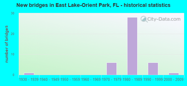
- New bridges - historical statistics
- 11930-1939
- 61970-1979
- 281980-1989
- 61990-1999
- 12000-2009

- Reconstructed bridges - Historical Statistics
- 31990-1999
- 02000-2009
- 12010-2019


- Bridge Condition - Superstructure
- 30.0%Very good
- 65.0%Good
- 5.0%Satisfactory

- Bridge Condition - Substructure
- 30.0%Very good
- 65.0%Good
- 5.0%Satisfactory

- Bridge Condition - Channel
- 7.7%Excellent
- 15.4%Very good
- 69.2%Good
- 7.7%Satisfactory

- Bridge Condition - Culverts
- 33.3%Good
- 66.7%Satisfactory
Find on map >> Show street view
Structure Number: 100293, Location: 0.5 MI EAST OF US-301 (Lat: 27.995564, Lng: -82.350775), Route carried "on" structure: Interstate 4, Year Built: 1977, Year Reconstructed: 2001, Status: Open, Structure Length: 16.01m (52.53ft), Average Daily Traffic: 77,500 (year 2021), Truck Traffic: 8%, Average Future Daily Traffic: 134,462 (year 2041), Design Load: HS 20, Features Intersected: TAMPA BYPASS CANAL
Minimum Vertical Clearance: 30+ m (98+ ft), Kilometerpoint: 23.081, Lanes on structure: 3, Base Highway Network: Yes, Owner: State Highway Agency, Approaching Roadway Width: 18.5m (60.7ft), Skew: 1 degrees, Material/Design: Prestressed concrete, Design/Construction: Stringer/Multi-beam, Number Of Spans In Main Unit: 12, Length of Maximum Span: 13.6m (44.6ft), Curb-To-Curb Width: 18.5m (60.7ft), Out-to-Out Width: 19.4m (63.6ft)
Condition: Deck: Good, Superstructure: Good, Substructure: Good, Channel: Good, Operating Rating: 57.2 metric tons, Method Used To Determine Operating Rating: Load Factor (LF), Inventory Rating: 33.6 metric tons, Method Used To Determine Inventory Rating: Load Factor (LF), Structural Evaluation: Better than present minimum criteria, Deck Geometry: Superior to present desirable criteria, Waterway Adequacy: Equal to present desirable criteria, Approach Roadway Alignment: Equal to present desirable criteria, Designated Inspection Frequency: Every 24 months, Underwater Inspection Frequency: Every 24 months, Inspection Date: March 2021, Underwater Inspection Date: Febuary 2021, Deck Structure Type: Concrete Cast-file-Place
Find on map >> Show street view
Structure Number: 100336, Location: 0.6MI NORTH OF SLIGH AVE (Lat: 28.017967, Lng: -82.373978), Route carried "on" structure: County highway , Year Built: 1977, Status: Open, Structure Length: 6.10m (20.01ft), Average Daily Traffic: 9,600 (year 2022), Truck Traffic: 5%, Average Future Daily Traffic: 12,000 (year 2042), Design Load: HS 20, Features Intersected: HARNEY CANAL C-136, Facility Carried by Structure: HARNEY RD
Minimum Vertical Clearance: 30+ m (98+ ft), Kilometerpoint: 3.935, Lanes on structure: 2, Owner: County Highway Agency, Approaching Roadway Width: 7.2m (23.6ft), Material/Design: Prestressed concrete, Design/Construction: Slab, Number Of Spans In Main Unit: 7, Length of Maximum Span: 9.2m (30.2ft), Curb-To-Curb Width: 13.3m (43.6ft), Out-to-Out Width: 14.3m (46.9ft)
Condition: Deck: Good, Superstructure: Good, Substructure: Satisfactory, Channel: Good, Operating Rating: 47.7 metric tons, Method Used To Determine Operating Rating: Allowable Stress (AS), Inventory Rating: 40.6 metric tons, Method Used To Determine Inventory Rating: Allowable Stress (AS), Structural Evaluation: Equal to present minimum criteria, Deck Geometry: Somewhat better than minimum adequacy, Waterway Adequacy: Better than present minimum criteria, Approach Roadway Alignment: Better than present minimum criteria, Designated Inspection Frequency: Every 24 months, Underwater Inspection Frequency: Every 24 months, Inspection Date: January 2022, Underwater Inspection Date: December 2021, Deck Structure Type: Concrete Precast Panels, Wearing Surface/Protective System: Wearing Surface: Integral Concrete
Find on map >> Show street view
Structure Number: 100369, Location: 0.08MI East of Maple Lane (Lat: 27.997158, Lng: -82.350681), Route carried "on" structure: County highway , Year Built: 1976, Status: Open, Structure Length: 15.61m (51.21ft), Average Daily Traffic: 500 (year 2021), Truck Traffic: 5%, Average Future Daily Traffic: 625 (year 2041), Design Load: HS 20+Mod, Features Intersected: TAMPA BYPASS CANAL, Facility Carried by Structure: EUREKA SPRINGS RD.
Minimum Vertical Clearance: 30+ m (98+ ft), Kilometerpoint: 0.491, Lanes on structure: 2, Owner: County Highway Agency, Approaching Roadway Width: 9.7m (31.8ft), Skew: 9 degrees, Material/Design: Prestressed concrete, Design/Construction: Stringer/Multi-beam, Number Of Spans In Main Unit: 12, Length of Maximum Span: 13.1m (43.0ft), Curb-To-Curb Width: 9.7m (31.8ft), Out-to-Out Width: 10.5m (34.4ft)
Condition: Deck: Good, Superstructure: Very good, Substructure: Good, Channel: Good, Operating Rating: 73.5 metric tons, Method Used To Determine Operating Rating: Allowable Stress (AS), Inventory Rating: 61.7 metric tons, Method Used To Determine Inventory Rating: Allowable Stress (AS), Structural Evaluation: Better than present minimum criteria, Deck Geometry: Equal to present minimum criteria, Waterway Adequacy: Equal to present desirable criteria, Approach Roadway Alignment: Equal to present desirable criteria, Designated Inspection Frequency: Every 24 months, Underwater Inspection Frequency: Every 24 months, Inspection Date: December 2021, Underwater Inspection Date: November 2021, Deck Structure Type: Concrete Cast-file-Place
Find on map >> Show street view
Structure Number: 100371, Location: 1.2Mi N OF DR MLK JR BLVD (Lat: 27.995000, Lng: -82.350736), Route carried "on" structure: County highway , Year Built: 1977, Status: Open, Structure Length: 15.62m (51.25ft), Average Daily Traffic: 2,000 (year 2021), Truck Traffic: 1%, Average Future Daily Traffic: 2,500 (year 2041), Design Load: HS 20, Features Intersected: TAMPA BYPASS CANAL, Facility Carried by Structure: GARDEN LANE
Minimum Vertical Clearance: 30+ m (98+ ft), Kilometerpoint: 0.000, Lanes on structure: 2, Owner: County Highway Agency, Approaching Roadway Width: 6.2m (20.3ft), Material/Design: Prestressed concrete, Design/Construction: Stringer/Multi-beam, Number Of Spans In Main Unit: 12, Length of Maximum Span: 13.1m (43.0ft), Curb-To-Curb Width: 10.9m (35.8ft), Out-to-Out Width: 11.8m (38.7ft)
Condition: Deck: Good, Superstructure: Good, Substructure: Good, Channel: Satisfactory, Operating Rating: 42.1 metric tons, Method Used To Determine Operating Rating: Allowable Stress (AS), Inventory Rating: 36.8 metric tons, Method Used To Determine Inventory Rating: Allowable Stress (AS), Structural Evaluation: Better than present minimum criteria, Deck Geometry: Equal to present minimum criteria, Waterway Adequacy: Better than present minimum criteria, Approach Roadway Alignment: Equal to present minimum criteria, Designated Inspection Frequency: Every 24 months, Underwater Inspection Frequency: Every 24 months, Inspection Date: December 2021, Underwater Inspection Date: November 2021, Deck Structure Type: Concrete Cast-file-Place
Find on map >> Show street view
Structure Number: 100393, Location: I-75 & I-4 INTERCHANGE (Lat: 28.002067, Lng: -82.327308), Route carried "on" structure: Interstate 75, Year Built: 1984, Status: Open, Structure Length: 15.30m (50.20ft), Average Daily Traffic: 128,500 (year 2021), Truck Traffic: 12%, Average Future Daily Traffic: 160,625 (year 2041), Design Load: HS 20+Mod, Features Intersected: I-4 AND RAMP C-1
Minimum Vertical Clearance: 30+ m (98+ ft), Kilometerpoint: 43.512, Lanes on structure: 3, Lanes under structure: 7, Base Highway Network: Yes, Owner: State Highway Agency, Approaching Roadway Width: 16.6m (54.5ft), Skew: 9 degrees, Material/Design: Prestressed concrete, Design/Construction: Stringer/Multi-beam, Number Of Spans In Main Unit: 7, Length of Maximum Span: 30.7m (100.7ft), Curb-To-Curb Width: 17.2m (56.4ft), Out-to-Out Width: 18.3m (60.0ft)
Condition: Deck: Good, Superstructure: Satisfactory, Substructure: Good, Operating Rating: 51.7 metric tons, Method Used To Determine Operating Rating: Allowable Stress (AS), Inventory Rating: 45.4 metric tons, Method Used To Determine Inventory Rating: Allowable Stress (AS), Structural Evaluation: Equal to present minimum criteria, Deck Geometry: Better than present minimum criteria, Underclear: Meets minimum limits, Approach Roadway Alignment: Equal to present desirable criteria, Length Of Structure Improvement: 1.53m (5.02ft), Designated Inspection Frequency: Every 24 months, Inspection Date: December 2021, Bridge Improvement Cost: $10,000, Roadway Improvement Cost: $1,000, Total Project Cost: $11,000, Deck Structure Type: Concrete Cast-file-Place
Find on map >> Show street view
Structure Number: 100395, Location: 0.1MI NORTH OF I-4 (Lat: 28.004244, Lng: -82.327536), Route carried "on" structure: Interstate 75, Year Built: 1983, Status: Open, Structure Length: 5.03m (16.50ft), Average Daily Traffic: 64,250 (year 2021), Truck Traffic: 9%, Average Future Daily Traffic: 111,474 (year 2041), Design Load: HS 20+Mod, Features Intersected: I-75 NB TO I-4 WB
Minimum Vertical Clearance: 30+ m (98+ ft), Kilometerpoint: 43.839, Lanes on structure: 3, Lanes under structure: 1, Base Highway Network: Yes, Owner: State Highway Agency, Approaching Roadway Width: 17.0m (55.8ft), Material/Design: Prestressed concrete, Design/Construction: Stringer/Multi-beam, Number Of Spans In Main Unit: 3, Length of Maximum Span: 24.4m (80.1ft), Curb-To-Curb Width: 17.0m (55.8ft), Out-to-Out Width: 18.3m (60.0ft)
Condition: Deck: Good, Superstructure: Very good, Substructure: Very good, Operating Rating: 48.1 metric tons, Method Used To Determine Operating Rating: Allowable Stress (AS), Inventory Rating: 42.6 metric tons, Method Used To Determine Inventory Rating: Allowable Stress (AS), Structural Evaluation: Equal to present desirable criteria, Deck Geometry: Equal to present minimum criteria, Underclear: Superior to present desirable criteria, Approach Roadway Alignment: Equal to present desirable criteria, Designated Inspection Frequency: Every 24 months, Inspection Date: December 2021, Deck Structure Type: Concrete Cast-file-Place
Find on map >> Show street view
Structure Number: 100396, Location: 0.1 MI NORTH OF I-4 (Lat: 28.004269, Lng: -82.327156), Route carried "on" structure: Interstate 75, Year Built: 1983, Status: Open, Structure Length: 5.03m (16.50ft), Average Daily Traffic: 128,500 (year 2021), Truck Traffic: 9%, Average Future Daily Traffic: 160,625 (year 2041), Design Load: HS 20+Mod, Features Intersected: I-75 NB TO I-4 WB
Minimum Vertical Clearance: 30+ m (98+ ft), Kilometerpoint: 43.839, Lanes on structure: 3, Lanes under structure: 1, Base Highway Network: Yes, Owner: State Highway Agency, Approaching Roadway Width: 17.0m (55.8ft), Material/Design: Prestressed concrete, Design/Construction: Stringer/Multi-beam, Number Of Spans In Main Unit: 3, Length of Maximum Span: 24.4m (80.1ft), Curb-To-Curb Width: 17.0m (55.8ft), Out-to-Out Width: 18.3m (60.0ft)
Condition: Deck: Good, Superstructure: Very good, Substructure: Very good, Operating Rating: 47.2 metric tons, Method Used To Determine Operating Rating: Allowable Stress (AS), Inventory Rating: 42.6 metric tons, Method Used To Determine Inventory Rating: Allowable Stress (AS), Structural Evaluation: Equal to present desirable criteria, Deck Geometry: Equal to present minimum criteria, Underclear: Superior to present desirable criteria, Approach Roadway Alignment: Equal to present desirable criteria, Designated Inspection Frequency: Every 24 months, Inspection Date: December 2021, Deck Structure Type: Concrete Cast-file-Place
Find on map >> Show street view
Structure Number: 100397, Location: 0.2MI NORTH OF I-4 (Lat: 28.005842, Lng: -82.327706), Route carried "on" structure: Interstate 75, Year Built: 1984, Year Reconstructed: 2004, Status: Open, Structure Length: 9.90m (32.48ft), Average Daily Traffic: 64,250 (year 2021), Truck Traffic: 9%, Average Future Daily Traffic: 111,474 (year 2041), Design Load: HS 20+Mod, Features Intersected: SLIGH AVE & RAMP D-1
Minimum Vertical Clearance: 30+ m (98+ ft), Kilometerpoint: 43.991, Lanes on structure: 3, Lanes under structure: 3, Base Highway Network: Yes, Owner: State Highway Agency, Approaching Roadway Width: 16.5m (54.1ft), Skew: 9 degrees, Material/Design: Prestressed concrete, Design/Construction: Stringer/Multi-beam, Number Of Spans In Main Unit: 4, Length of Maximum Span: 32.7m (107.3ft), Curb-To-Curb Width: 17.3m (56.8ft), Out-to-Out Width: 18.4m (60.4ft)
Condition: Deck: Good, Superstructure: Very good, Substructure: Very good, Operating Rating: 78.4 metric tons, Method Used To Determine Operating Rating: Load Factor (LF), Inventory Rating: 47.0 metric tons, Method Used To Determine Inventory Rating: Load Factor (LF), Structural Evaluation: Equal to present desirable criteria, Deck Geometry: Better than present minimum criteria, Underclear: Equal to present minimum criteria, Approach Roadway Alignment: Equal to present desirable criteria, Designated Inspection Frequency: Every 24 months, Inspection Date: December 2021, Deck Structure Type: Concrete Cast-file-Place
Find on map >> Show street view
Structure Number: 100416, Location: I-4 & I-75 INTERCHANGE (Lat: 27.999692, Lng: -82.327075), Route carried "on" structure: Interstate 75, Year Built: 1983, Year Reconstructed: 2004, Status: Open, Structure Length: 4.54m (14.90ft), Average Daily Traffic: 128,500 (year 2021), Truck Traffic: 12%, Average Future Daily Traffic: 160,625 (year 2041), Design Load: HS 20+Mod, Features Intersected: I-4 EB TO I-75 NB
Minimum Vertical Clearance: 30+ m (98+ ft), Kilometerpoint: 43.340, Lanes on structure: 4, Lanes under structure: 1, Base Highway Network: Yes, Owner: State Highway Agency, Approaching Roadway Width: 21.9m (71.9ft), Skew: 1 degrees, Material/Design: Prestressed concrete, Design/Construction: Stringer/Multi-beam, Number Of Spans In Main Unit: 3, Length of Maximum Span: 25.9m (85.0ft), Curb-To-Curb Width: 21.9m (71.9ft), Out-to-Out Width: 26.5m (86.9ft)
Condition: Deck: Good, Superstructure: Good, Substructure: Good, Operating Rating: 57.2 metric tons, Method Used To Determine Operating Rating: Allowable Stress (AS), Inventory Rating: 49.0 metric tons, Method Used To Determine Inventory Rating: Allowable Stress (AS), Structural Evaluation: Better than present minimum criteria, Deck Geometry: Better than present minimum criteria, Underclear: Somewhat better than minimum adequacy, Approach Roadway Alignment: Equal to present desirable criteria, Designated Inspection Frequency: Every 24 months, Inspection Date: December 2021, Deck Structure Type: Concrete Cast-file-Place
Find on map >> Show street view
Structure Number: 100418, Location: 0.2MI NORTH OF I-4 (Lat: 28.008625, Lng: -82.327819), Route carried "on" structure: Interstate 75, Year Built: 1985, Status: Open, Structure Length: 1.52m (4.99ft), Average Daily Traffic: 128,500 (year 2021), Truck Traffic: 9%, Average Future Daily Traffic: 222,948 (year 2041), Design Load: HL 93, Features Intersected: HARNEY FLATS CANAL
Minimum Vertical Clearance: 30+ m (98+ ft), Kilometerpoint: 44.354, Lanes on structure: 10, Base Highway Network: Yes, Owner: State Highway Agency, Approaching Roadway Width: 62.8m (206.0ft), Skew: 21 degrees, Material/Design: Concrete, Design/Construction: Culvert, Number Of Spans In Main Unit: 4, Length of Maximum Span: 3.8m (12.5ft)
Condition: Channel: Good, Culverts: Good, Operating Rating: 51.0 metric tons, Method Used To Determine Operating Rating: Load and Resistance Factor (LRFR), Inventory Rating: 39.2 metric tons, Method Used To Determine Inventory Rating: Load and Resistance Factor (LRFR), Structural Evaluation: Better than present minimum criteria, Waterway Adequacy: Equal to present desirable criteria, Approach Roadway Alignment: Equal to present desirable criteria, Designated Inspection Frequency: Every 24 months, Underwater Inspection Frequency: Every 24 months, Inspection Date: October 2021, Underwater Inspection Date: September 2021
Find on map >> Show street view
Structure Number: 100424, Location: 0.4MI S OF I-4 (SR-400) (Lat: 27.997061, Lng: -82.327047), Route carried "on" structure: Ramp Interstate 75, Year Built: 1983, Status: Open, Structure Length: 5.77m (18.93ft), Average Daily Traffic: 16,000 (year 2021), Truck Traffic: 9%, Average Future Daily Traffic: 27,760 (year 2041), Design Load: HS 20+Mod, Features Intersected: US-92 (SR-600)
Minimum Vertical Clearance: 30+ m (98+ ft), Kilometerpoint: 0.880, Lanes on structure: 1, Lanes under structure: 2, Owner: State Highway Agency, Approaching Roadway Width: 7.7m (25.3ft), Material/Design: Prestressed concrete, Design/Construction: Stringer/Multi-beam, Number Of Spans In Main Unit: 3, Length of Maximum Span: 32.5m (106.6ft), Curb-To-Curb Width: 8.5m (27.9ft), Out-to-Out Width: 9.4m (30.8ft)
Condition: Deck: Good, Superstructure: Good, Substructure: Very good, Operating Rating: 67.1 metric tons, Method Used To Determine Operating Rating: Allowable Stress (AS), Inventory Rating: 56.2 metric tons, Method Used To Determine Inventory Rating: Allowable Stress (AS), Structural Evaluation: Better than present minimum criteria, Deck Geometry: Superior to present desirable criteria, Underclear: Equal to present minimum criteria, Approach Roadway Alignment: Equal to present desirable criteria, Designated Inspection Frequency: Every 24 months, Inspection Date: December 2021, Deck Structure Type: Concrete Precast Panels
Find on map >> Show street view
Structure Number: 100426, Location: I-4 & I-75 INTERCHANGE (Lat: 28.001528, Lng: -82.330333), Route carried "on" structure: Ramp Interstate 75, Year Built: 1985, Status: Open, Structure Length: 11.86m (38.91ft), Average Daily Traffic: 13,500 (year 2021), Truck Traffic: 9%, Average Future Daily Traffic: 23,422 (year 2041), Design Load: HS 20+Mod, Features Intersected: I-4 & RAMP A-1
Minimum Vertical Clearance: 30+ m (98+ ft), Kilometerpoint: 0.195, Lanes on structure: 1, Lanes under structure: 7, Owner: State Highway Agency, Approaching Roadway Width: 8.2m (26.9ft), Skew: 2 degrees, Material/Design: Prestressed concrete, Design/Construction: Stringer/Multi-beam, Number Of Spans In Main Unit: 5, Length of Maximum Span: 32.9m (107.9ft), Curb-To-Curb Width: 8.2m (26.9ft), Out-to-Out Width: 9.1m (29.9ft)
Condition: Deck: Good, Superstructure: Good, Substructure: Good, Operating Rating: 67.1 metric tons, Method Used To Determine Operating Rating: Allowable Stress (AS), Inventory Rating: 46.3 metric tons, Method Used To Determine Inventory Rating: Allowable Stress (AS), Structural Evaluation: Better than present minimum criteria, Deck Geometry: Superior to present desirable criteria, Underclear: Meets minimum limits, Approach Roadway Alignment: Better than present minimum criteria, Designated Inspection Frequency: Every 24 months, Inspection Date: December 2021, Deck Structure Type: Concrete Cast-file-Place
Find on map >> Show street view
Structure Number: 10043, Location: I-4 & I-75 INTERCHANGE (Lat: 28.005389, Lng: -82.329361), Route carried "on" structure: Ramp Interstate 75, Year Built: 1985, Year Reconstructed: 2019, Status: Open, Structure Length: 7.10m (23.29ft), Average Daily Traffic: 13,000 (year 2021), Truck Traffic: 9%, Average Future Daily Traffic: 22,555 (year 2041), Design Load: HS 20, Features Intersected: SLIGH AVENUE
Minimum Vertical Clearance: 30+ m (98+ ft), Kilometerpoint: 0.343, Lanes on structure: 1, Lanes under structure: 2, Owner: State Highway Agency, Approaching Roadway Width: 13.4m (44.0ft), Skew: 5 degrees, Material/Design: Prestressed concrete, Design/Construction: Stringer/Multi-beam, Number Of Spans In Main Unit: 3, Length of Maximum Span: 35.7m (117.1ft), Curb-To-Curb Width: 13.4m (44.0ft), Out-to-Out Width: 14.3m (46.9ft)
Condition: Deck: Good, Superstructure: Good, Substructure: Very good, Operating Rating: 43.5 metric tons, Method Used To Determine Operating Rating: Load and Resistance Factor (LRFR), Inventory Rating: 33.7 metric tons, Method Used To Determine Inventory Rating: Load and Resistance Factor (LRFR), Structural Evaluation: Better than present minimum criteria, Deck Geometry: Superior to present desirable criteria, Underclear: Equal to present minimum criteria, Approach Roadway Alignment: Equal to present desirable criteria, Designated Inspection Frequency: Every 24 months, Inspection Date: December 2021, Deck Structure Type: Concrete Cast-file-Place
Find on map >> Show street view
Structure Number: 100432, Location: I-4 & I-75 INTERCHANGE (Lat: 28.001900, Lng: -82.328758), Route carried "on" structure: Ramp Interstate 75, Year Built: 1984, Status: Open, Structure Length: 31.17m (102.26ft), Average Daily Traffic: 17,000 (year 2021), Truck Traffic: 7%, Average Future Daily Traffic: 29,495 (year 2041), Design Load: HS 20+Mod, Features Intersected: I-4 & RAMPS A-1 & C-1
Minimum Vertical Clearance: 30+ m (98+ ft), Kilometerpoint: 0.674, Lanes on structure: 1, Lanes under structure: 8, Owner: State Highway Agency, Approaching Roadway Width: 8.5m (27.9ft), Skew: 9 degrees, Material/Design: Prestressed concrete, Design/Construction: Stringer/Multi-beam, Number Of Spans In Main Unit: 12, Length of Maximum Span: 34.5m (113.2ft), Curb-To-Curb Width: 8.5m (27.9ft), Out-to-Out Width: 9.6m (31.5ft)
Condition: Deck: Good, Superstructure: Good, Substructure: Very good, Operating Rating: 67.1 metric tons, Method Used To Determine Operating Rating: Allowable Stress (AS), Inventory Rating: 52.6 metric tons, Method Used To Determine Inventory Rating: Allowable Stress (AS), Structural Evaluation: Better than present minimum criteria, Deck Geometry: Superior to present desirable criteria, Underclear: Meets minimum limits, Approach Roadway Alignment: Better than present minimum criteria, Designated Inspection Frequency: Every 24 months, Inspection Date: December 2021, Deck Structure Type: Concrete Cast-file-Place
Find on map >> Show street view
Structure Number: 100473, Location: 1.9MI NORTH OF I-4 (Lat: 28.028886, Lng: -82.342000), Route carried "on" structure: Interstate 75, Year Built: 1984, Status: Open, Structure Length: 25.30m (83.01ft), Average Daily Traffic: 64,250 (year 2021), Truck Traffic: 9%, Average Future Daily Traffic: 111,474 (year 2041), Design Load: HS 20+Mod, Features Intersected: TAMPA BYPASS CANAL
Minimum Vertical Clearance: 30+ m (98+ ft), Kilometerpoint: 46.962, Lanes on structure: 3, Base Highway Network: Yes, Owner: State Highway Agency, Approaching Roadway Width: 17.1m (56.1ft), Skew: 4 degrees, Material/Design: Prestressed concrete, Design/Construction: Stringer/Multi-beam, Number Of Spans In Main Unit: 12, Length of Maximum Span: 21.3m (69.9ft), Curb-To-Curb Width: 17.1m (56.1ft), Out-to-Out Width: 18.0m (59.1ft)
Condition: Deck: Good, Superstructure: Very good, Substructure: Good, Channel: Good, Operating Rating: 81.2 metric tons, Method Used To Determine Operating Rating: Load Factor (LF), Inventory Rating: 48.7 metric tons, Method Used To Determine Inventory Rating: Load Factor (LF), Structural Evaluation: Better than present minimum criteria, Deck Geometry: Equal to present minimum criteria, Waterway Adequacy: Equal to present desirable criteria, Approach Roadway Alignment: Equal to present desirable criteria, Designated Inspection Frequency: Every 24 months, Underwater Inspection Frequency: Every 24 months, Inspection Date: October 2021, Underwater Inspection Date: September 2021, Deck Structure Type: Concrete Cast-file-Place
Find on map >> Show street view
Structure Number: 100474, Location: 1.9MI NORTH OF I-4 (Lat: 28.029322, Lng: -82.341892), Route carried "on" structure: Interstate 75, Year Built: 1985, Status: Open, Structure Length: 25.30m (83.01ft), Average Daily Traffic: 64,250 (year 2021), Truck Traffic: 9%, Average Future Daily Traffic: 111,474 (year 2041), Design Load: HS 20+Mod, Features Intersected: TAMPA BYPASS CANAL
Minimum Vertical Clearance: 30+ m (98+ ft), Kilometerpoint: 47.001, Lanes on structure: 3, Base Highway Network: Yes, Owner: State Highway Agency, Approaching Roadway Width: 17.1m (56.1ft), Skew: 4 degrees, Material/Design: Prestressed concrete, Design/Construction: Stringer/Multi-beam, Number Of Spans In Main Unit: 12, Length of Maximum Span: 21.5m (70.5ft), Curb-To-Curb Width: 17.1m (56.1ft), Out-to-Out Width: 18.0m (59.1ft)
Condition: Deck: Good, Superstructure: Good, Substructure: Good, Channel: Good, Operating Rating: 81.2 metric tons, Method Used To Determine Operating Rating: Load Factor (LF), Inventory Rating: 48.7 metric tons, Method Used To Determine Inventory Rating: Load Factor (LF), Structural Evaluation: Better than present minimum criteria, Deck Geometry: Equal to present minimum criteria, Waterway Adequacy: Equal to present desirable criteria, Approach Roadway Alignment: Equal to present desirable criteria, Designated Inspection Frequency: Every 24 months, Underwater Inspection Frequency: Every 24 months, Inspection Date: October 2021, Underwater Inspection Date: September 2021, Deck Structure Type: Concrete Cast-file-Place
Find on map >> Show street view
Structure Number: 100592, Location: 0.9MI N OF SR-574 (Lat: 27.995833, Lng: -82.357681), Route carried "on" structure: State highway 301, Year Built: 1999, Status: Open, Structure Length: 11.56m (37.93ft), Average Daily Traffic: 32,500 (year 2020), Truck Traffic: 11%, Average Future Daily Traffic: 56,388 (year 2042), Design Load: HL 93, Features Intersected: I-4 (SR-400)
Minimum Vertical Clearance: 30+ m (98+ ft), Kilometerpoint: 41.481, Lanes on structure: 6, Lanes under structure: 13, Base Highway Network: Yes, Owner: State Highway Agency, Approaching Roadway Width: 30.5m (100.1ft), Skew: 30 degrees, Material/Design: Prestressed concrete, Design/Construction: Stringer/Multi-beam, Number Of Spans In Main Unit: 4, Length of Maximum Span: 33.1m (108.6ft), Curb or Sidewalk Widths: Left: 1.7m (5.6ft), Right: 1.7m (5.6ft), Curb-To-Curb Width: 29.9m (98.1ft), Out-to-Out Width: 35.7m (117.1ft)
Condition: Deck: Good, Superstructure: Very good, Substructure: Good, Operating Rating: 49.6 metric tons, Method Used To Determine Operating Rating: Load and Resistance Factor (LRFR), Inventory Rating: 44.7 metric tons, Method Used To Determine Inventory Rating: Load and Resistance Factor (LRFR), Structural Evaluation: Better than present minimum criteria, Deck Geometry: Superior to present desirable criteria, Underclear: Equal to present minimum criteria, Approach Roadway Alignment: Equal to present desirable criteria, Designated Inspection Frequency: Every 24 months, Inspection Date: March 2021, Deck Structure Type: Concrete Cast-file-Place
Find on map >> Show street view
Structure Number: 100596, Location: 0.5 MI EAST OF US-301 (Lat: 27.995886, Lng: -82.350722), Route carried "on" structure: Interstate 4, Year Built: 1999, Status: Open, Structure Length: 16.48m (54.07ft), Average Daily Traffic: 77,500 (year 2021), Truck Traffic: 8%, Average Future Daily Traffic: 134,462 (year 2041), Design Load: HS 20+Mod, Features Intersected: TAMPA BYPASS CANAL
Minimum Vertical Clearance: 30+ m (98+ ft), Kilometerpoint: 23.089, Lanes on structure: 3, Base Highway Network: Yes, Owner: State Highway Agency, Approaching Roadway Width: 21.7m (71.2ft), Material/Design: Prestressed concrete, Design/Construction: Stringer/Multi-beam, Number Of Spans In Main Unit: 12, Length of Maximum Span: 15.6m (51.2ft), Curb-To-Curb Width: 20.7m (67.9ft), Out-to-Out Width: 21.7m (71.2ft)
Condition: Deck: Good, Superstructure: Good, Substructure: Good, Channel: Very good, Operating Rating: 66.0 metric tons, Method Used To Determine Operating Rating: Load Factor (LF), Inventory Rating: 39.6 metric tons, Method Used To Determine Inventory Rating: Load Factor (LF), Structural Evaluation: Better than present minimum criteria, Deck Geometry: Superior to present desirable criteria, Waterway Adequacy: Equal to present desirable criteria, Approach Roadway Alignment: Equal to present desirable criteria, Designated Inspection Frequency: Every 24 months, Underwater Inspection Frequency: Every 24 months, Inspection Date: March 2021, Underwater Inspection Date: Febuary 2021, Deck Structure Type: Concrete Cast-file-Place
Find on map >> Show street view
Structure Number: 100597, Location: 0.5MI EAST OF US-301 (Lat: 27.996097, Lng: -82.350717), Route carried "on" structure: Ramp Interstate 4, Year Built: 1999, Status: Open, Structure Length: 16.48m (54.07ft), Average Daily Traffic: 23,000 (year 2021), Truck Traffic: 9%, Average Future Daily Traffic: 39,905 (year 2041), Design Load: HS 20+Mod, Features Intersected: TAMPA BYPASS CANAL
Minimum Vertical Clearance: 30+ m (98+ ft), Kilometerpoint: 0.357, Lanes on structure: 2, Owner: State Highway Agency, Approaching Roadway Width: 12.1m (39.7ft), Skew: 1 degrees, Material/Design: Prestressed concrete, Design/Construction: Stringer/Multi-beam, Number Of Spans In Main Unit: 12, Length of Maximum Span: 15.7m (51.5ft), Curb-To-Curb Width: 12.1m (39.7ft), Out-to-Out Width: 13.2m (43.3ft)
Condition: Deck: Good, Superstructure: Good, Substructure: Good, Channel: Very good, Operating Rating: 74.8 metric tons, Method Used To Determine Operating Rating: Load Factor (LF), Inventory Rating: 44.9 metric tons, Method Used To Determine Inventory Rating: Load Factor (LF), Structural Evaluation: Better than present minimum criteria, Deck Geometry: Superior to present desirable criteria, Waterway Adequacy: Equal to present desirable criteria, Approach Roadway Alignment: Equal to present desirable criteria, Designated Inspection Frequency: Every 24 months, Underwater Inspection Frequency: Every 24 months, Inspection Date: March 2021, Underwater Inspection Date: Febuary 2021, Deck Structure Type: Concrete Cast-file-Place
Find on map >> Show street view
Structure Number: 100687, Location: 1.3MI NORTH OF I-4 (Lat: 28.013664, Lng: -82.354247), Route carried "on" structure: US 301, Year Built: 2007, Status: Open, Structure Length: 6.08m (19.95ft), Average Daily Traffic: 25,500 (year 2020), Truck Traffic: 11%, Average Future Daily Traffic: 44,242 (year 2042), Design Load: HL 93, Features Intersected: HARNEY CANAL
Minimum Vertical Clearance: 30.45m (99.90ft), Kilometerpoint: 2.017, Lanes on structure: 5, Base Highway Network: Yes, Owner: State Highway Agency, Approaching Roadway Width: 9.1m (29.9ft), Skew: 20 degrees, Material/Design: Concrete continuous, Design/Construction: Slab, Number Of Spans In Main Unit: 6, Length of Maximum Span: 10.1m (33.1ft), Curb or Sidewalk Widths: Left: 1.5m (4.9ft), Right: 3.0m (9.8ft), Curb-To-Curb Width: 29.9m (98.1ft), Out-to-Out Width: 37.0m (121.4ft)
Condition: Deck: Good, Superstructure: Good, Substructure: Good, Channel: Excellent, Operating Rating: 69.5 metric tons, Method Used To Determine Operating Rating: Load Factor (LF), Inventory Rating: 41.7 metric tons, Method Used To Determine Inventory Rating: Load Factor (LF), Structural Evaluation: Better than present minimum criteria, Deck Geometry: Superior to present desirable criteria, Waterway Adequacy: Equal to present desirable criteria, Approach Roadway Alignment: Equal to present desirable criteria, Designated Inspection Frequency: Every 24 months, Underwater Inspection Frequency: Every 24 months, Inspection Date: September 2021, Underwater Inspection Date: August 2021, Deck Structure Type: Concrete Cast-file-Place
Find on map >> Show street view
Structure Number: 104126, Location: 0.2MI S OF MLK JR BLVD (Lat: 27.977933, Lng: -82.346853), Route carried "on" structure: County highway , Year Built: 1978, Status: Open, Structure Length: 1.70m (5.58ft), Average Daily Traffic: 1,641 (year 2021), Truck Traffic: 2%, Average Future Daily Traffic: 2,051 (year 2041), Design Load: HS 20, Features Intersected: SIX MILE CREEK, Facility Carried by Structure: RIGA BLVD
Minimum Vertical Clearance: 30+ m (98+ ft), Kilometerpoint: 0.000, Lanes on structure: 2, Owner: County Highway Agency, Approaching Roadway Width: 9.1m (29.9ft), Material/Design: Prestressed concrete, Design/Construction: Slab, Number Of Spans In Main Unit: 2, Length of Maximum Span: 8.5m (27.9ft), Curb-To-Curb Width: 9.1m (29.9ft), Out-to-Out Width: 9.9m (32.5ft)
Condition: Deck: Good, Superstructure: Good, Substructure: Good, Channel: Good, Operating Rating: 46.2 metric tons, Method Used To Determine Operating Rating: Load Factor (LF), Inventory Rating: 38.6 metric tons, Method Used To Determine Inventory Rating: Load Factor (LF), Structural Evaluation: Better than present minimum criteria, Deck Geometry: Somewhat better than minimum adequacy, Waterway Adequacy: Equal to present desirable criteria, Approach Roadway Alignment: Equal to present desirable criteria, Designated Inspection Frequency: Every 24 months, Inspection Date: December 2021, Deck Structure Type: Concrete Precast Panels, Wearing Surface/Protective System: Wearing Surface: Bituminous
Find on map >> Show street view
Structure Number: 10413, Location: 0.2 MI S OF MLK JR BLVD. (Lat: 27.978881, Lng: -82.350117), Route carried "on" structure: County highway , Year Built: 1981, Status: Open, Structure Length: 0.91m (2.99ft), Average Daily Traffic: 1,920 (year 2020), Truck Traffic: 5%, Average Future Daily Traffic: 3,331 (year 2042), Features Intersected: SIX MILE CREEK, Facility Carried by Structure: COCONUT PALM DR.
Minimum Vertical Clearance: 30+ m (98+ ft), Kilometerpoint: 0.000, Lanes on structure: 2, Owner: County Highway Agency, Approaching Roadway Width: 9.3m (30.5ft), Skew: 4 degrees, Material/Design: Concrete, Design/Construction: Culvert, Number Of Spans In Main Unit: 2, Length of Maximum Span: 4.3m (14.1ft)
Condition: Channel: Good, Culverts: Satisfactory, Operating Rating: 61.6 metric tons, Method Used To Determine Operating Rating: Load Factor (LF), Inventory Rating: 37.0 metric tons, Method Used To Determine Inventory Rating: Load Factor (LF), Structural Evaluation: Equal to present minimum criteria, Waterway Adequacy: Better than present minimum criteria, Approach Roadway Alignment: Equal to present minimum criteria, Designated Inspection Frequency: Every 24 months, Underwater Inspection Frequency: Every 24 months, Inspection Date: November 2021, Underwater Inspection Date: October 2021, Wearing Surface/Protective System: Wearing Surface: Other
Find on map >> Show street view
Structure Number: 104156, Location: 0.2MI. SOUTH OF SR-574 (Lat: 27.978253, Lng: -82.335072), Route carried "on" structure: City street , Year Built: 1987, Status: Open, Structure Length: 0.78m (2.56ft), Average Daily Traffic: 20,000 (year 2021), Truck Traffic: 10%, Average Future Daily Traffic: 40,000 (year 2041), Design Load: HS 20, Features Intersected: SIX MILE CREEK, Facility Carried by Structure: FAULKENBURG ROAD
Minimum Vertical Clearance: 30+ m (98+ ft), Kilometerpoint: 0.000, Lanes on structure: 5, Owner: County Highway Agency, Approaching Roadway Width: 22.9m (75.1ft), Skew: 26 degrees, Material/Design: Concrete, Design/Construction: Culvert, Number Of Spans In Main Unit: 2, Length of Maximum Span: 3.9m (12.8ft), Curb or Sidewalk Widths: Left: 1.5m (4.9ft), Right: 1.5m (4.9ft)
Condition: Channel: Good, Culverts: Satisfactory, Operating Rating: 67.4 metric tons, Method Used To Determine Operating Rating: Load Factor (LF), Inventory Rating: 40.5 metric tons, Method Used To Determine Inventory Rating: Load Factor (LF), Structural Evaluation: Equal to present minimum criteria, Waterway Adequacy: Better than present minimum criteria, Approach Roadway Alignment: Equal to present desirable criteria, Designated Inspection Frequency: Every 24 months, Inspection Date: December 2021
Find on map >> Show street view
Structure Number: 100011, Location: 1.3MI NORTH OF SR-60 (Lat: 27.967528, Lng: -82.360500), Route carried "under" structure: County highway 574, Year Built: 1931, Structure Length: 0. m, Average Daily Traffic: 10,000 (year 2020), Truck Traffic: 9%, Features Intersected: CR-574 & CSX R/R, Facility Carried by Structure: US-301 SB (SR-43)
Minimum Vertical Clearance: 6.22m (20.41ft), Kilometerpoint: 0.489, Lanes on structure: 2, Lanes under structure: 2, Material/Design: Concrete, Design/Construction: Tee Beam, Length of Maximum Span: 11.7m (38.4ft)
Find on map >> Show street view
Structure Number: 100102, Location: 1.3 MILES NORTH OF SR-60 (Lat: 27.967558, Lng: -82.360269), Route carried "under" structure: County highway 574, Year Built: 1970, Structure Length: 0. m, Average Daily Traffic: 10,000 (year 2020), Truck Traffic: 9%, Features Intersected: CR-574, Facility Carried by Structure: US-301 (SR-43 NB)
Minimum Vertical Clearance: 6.43m (21.10ft), Kilometerpoint: 0.510, Lanes on structure: 2, Lanes under structure: 2, Material/Design: Prestressed concrete, Design/Construction: Stringer/Multi-beam, Length of Maximum Span: 13.6m (44.6ft)
Find on map >> Show street view
Structure Number: 100393, Location: I-75 & I-4 INTERCHANGE (Lat: 28.002067, Lng: -82.327308), Route carried "under" structure: Ramp Interstate 4, Year Built: 1984, Structure Length: 0. m, Average Daily Traffic: 13,500 (year 2021), Truck Traffic: 9%, Features Intersected: I-4 AND RAMP C-1, Facility Carried by Structure: I-75 SB
Minimum Vertical Clearance: 6.89m (22.60ft), Kilometerpoint: 0.000, Lanes on structure: 3, Lanes under structure: 1, Material/Design: Prestressed concrete, Design/Construction: Stringer/Multi-beam, Length of Maximum Span: 30.7m (100.7ft)
Find on map >> Show street view
Structure Number: 100393, Location: I-75 & I-4 INTERCHANGE (Lat: 28.002067, Lng: -82.327308), Route carried "under" structure: Interstate 4, Year Built: 1984, Structure Length: 0. m, Average Daily Traffic: 130,000 (year 2021), Truck Traffic: 16%, Features Intersected: I-4 AND RAMP C-1, Facility Carried by Structure: I-75 SB
Minimum Vertical Clearance: 7.25m (23.79ft), Kilometerpoint: 25.547, Lanes on structure: 3, Lanes under structure: 6, Material/Design: Prestressed concrete, Design/Construction: Stringer/Multi-beam, Length of Maximum Span: 30.7m (100.7ft)
Find on map >> Show street view
Structure Number: 100395, Location: 0.1MI NORTH OF I-4 (Lat: 28.004244, Lng: -82.327536), Route carried "under" structure: Ramp Interstate 75, Year Built: 1983, Structure Length: 0. m, Average Daily Traffic: 128,500 (year 2021), Truck Traffic: 9%, Features Intersected: I-75 NB TO I-4 WB
Minimum Vertical Clearance: 7.04m (23.10ft), Kilometerpoint: 0.713, Lanes on structure: 3, Lanes under structure: 1, Material/Design: Prestressed concrete, Design/Construction: Stringer/Multi-beam, Length of Maximum Span: 24.4m (80.1ft)
Find on map >> Show street view
Structure Number: 100396, Location: 0.1 MI NORTH OF I-4 (Lat: 28.004269, Lng: -82.327156), Route carried "under" structure: Ramp Interstate 75, Year Built: 1983, Structure Length: 0. m, Average Daily Traffic: 17,500 (year 2021), Truck Traffic: 9%, Features Intersected: I-75 NB TO I-4 WB
Minimum Vertical Clearance: 6.74m (22.11ft), Kilometerpoint: 0.674, Lanes on structure: 3, Lanes under structure: 1, Material/Design: Prestressed concrete, Design/Construction: Stringer/Multi-beam, Length of Maximum Span: 24.4m (80.1ft)
Find on map >> Show street view
Structure Number: 100397, Location: 0.2MI NORTH OF I-4 (Lat: 28.005842, Lng: -82.327706), Route carried "under" structure: City street , Year Built: 1984, Structure Length: 0. m, Average Daily Traffic: 7,000 (year 2021), Truck Traffic: 30%, Features Intersected: SLIGH AVE & RAMP D-1, Facility Carried by Structure: I-75 SB
Minimum Vertical Clearance: 6.37m (20.90ft), Kilometerpoint: 0.000, Lanes on structure: 3, Lanes under structure: 2, Material/Design: Prestressed concrete, Design/Construction: Stringer/Multi-beam, Length of Maximum Span: 32.7m (107.3ft)
Find on map >> Show street view
Structure Number: 100397, Location: 0.2MI NORTH OF I-4 (Lat: 28.005842, Lng: -82.327706), Route carried "under" structure: Ramp Interstate , Year Built: 1984, Structure Length: 0. m, Average Daily Traffic: 19,000 (year 2021), Truck Traffic: 9%, Features Intersected: SLIGH AVE & RAMP D-1, Facility Carried by Structure: I-75 SB
Minimum Vertical Clearance: 5.09m (16.70ft), Kilometerpoint: 0.000, Lanes on structure: 3, Lanes under structure: 1, Material/Design: Prestressed concrete, Design/Construction: Stringer/Multi-beam, Length of Maximum Span: 32.7m (107.3ft)
Find on map >> Show street view
Structure Number: 100416, Location: I-4 & I-75 INTERCHANGE (Lat: 27.999692, Lng: -82.327075), Route carried "under" structure: Ramp Interstate 4, Year Built: 1983, Structure Length: 0. m, Average Daily Traffic: 11,500 (year 2021), Truck Traffic: 9%, Features Intersected: I-4 EB TO I-75 NB, Facility Carried by Structure: I-75 SB (SR-93A)
Minimum Vertical Clearance: 4.85m (15.91ft), Kilometerpoint: 0.232, Lanes on structure: 4, Lanes under structure: 1, Material/Design: Prestressed concrete, Design/Construction: Stringer/Multi-beam, Length of Maximum Span: 25.9m (85.0ft)
Find on map >> Show street view
Structure Number: 100424, Location: 0.4MI S OF I-4 (SR-400) (Lat: 27.997061, Lng: -82.327047), Route carried "under" structure: US 92, Year Built: 1983, Structure Length: 0. m, Average Daily Traffic: 12,400 (year 2021), Truck Traffic: 13%, Features Intersected: US-92 (SR-600), Facility Carried by Structure: I-4 EB TO I-75 SB
Minimum Vertical Clearance: 4.94m (16.21ft), Kilometerpoint: 12.233, Lanes on structure: 1, Lanes under structure: 2, Material/Design: Prestressed concrete, Design/Construction: Stringer/Multi-beam, Length of Maximum Span: 32.5m (106.6ft)
Find on map >> Show street view
Structure Number: 100426, Location: I-4 & I-75 INTERCHANGE (Lat: 28.001528, Lng: -82.330333), Route carried "under" structure: Interstate 4, Year Built: 1985, Structure Length: 0. m, Average Daily Traffic: 132,000 (year 2021), Truck Traffic: 13%, Features Intersected: I-4 & RAMP A-1
Minimum Vertical Clearance: 5.33m (17.49ft), Kilometerpoint: 25.257, Lanes on structure: 1, Lanes under structure: 6, Material/Design: Prestressed concrete, Design/Construction: Stringer/Multi-beam, Length of Maximum Span: 32.9m (107.9ft)
Find on map >> Show street view
Structure Number: 100426, Location: I-4 & I-75 INTERCHANGE (Lat: 28.001528, Lng: -82.330333), Route carried "under" structure: Ramp Interstate 4, Year Built: 1985, Structure Length: 0. m, Average Daily Traffic: 5,000 (year 2021), Truck Traffic: 30%, Features Intersected: I-4 & RAMP A-1
Minimum Vertical Clearance: 5.36m (17.59ft), Kilometerpoint: 0.000, Lanes on structure: 1, Lanes under structure: 1, Material/Design: Prestressed concrete, Design/Construction: Stringer/Multi-beam, Length of Maximum Span: 32.9m (107.9ft)
Find on map >> Show street view
Structure Number: 10043, Location: I-4 & I-75 INTERCHANGE (Lat: 28.005389, Lng: -82.329361), Route carried "under" structure: County highway , Year Built: 1985, Structure Length: 0. m, Average Daily Traffic: 8,000 (year 2021), Truck Traffic: 30%, Features Intersected: SLIGH AVENUE, Facility Carried by Structure: I-75 SB TO I-4
Minimum Vertical Clearance: 4.91m (16.11ft), Kilometerpoint: 0.000, Lanes on structure: 1, Lanes under structure: 2, Material/Design: Prestressed concrete, Design/Construction: Stringer/Multi-beam, Length of Maximum Span: 35.7m (117.1ft)
Find on map >> Show street view
Structure Number: 100432, Location: I-4 & I-75 INTERCHANGE (Lat: 28.001900, Lng: -82.328758), Route carried "under" structure: Ramp Interstate 75, Year Built: 1984, Structure Length: 0. m, Average Daily Traffic: 13,500 (year 2021), Truck Traffic: 9%, Features Intersected: I-4 & RAMPS A-1 & C-1
Minimum Vertical Clearance: 4.60m (15.09ft), Kilometerpoint: 0.000, Lanes on structure: 1, Lanes under structure: 1, Material/Design: Prestressed concrete, Design/Construction: Stringer/Multi-beam, Length of Maximum Span: 34.5m (113.2ft)
Find on map >> Show street view
Structure Number: 100432, Location: I-4 & I-75 INTERCHANGE (Lat: 28.001900, Lng: -82.328758), Route carried "under" structure: Interstate 4, Year Built: 1984, Structure Length: 0. m, Average Daily Traffic: 132,000 (year 2021), Truck Traffic: 13%, Features Intersected: I-4 & RAMPS A-1 & C-1
Minimum Vertical Clearance: 6.34m (20.80ft), Kilometerpoint: 25.428, Lanes on structure: 1, Lanes under structure: 6, Material/Design: Prestressed concrete, Design/Construction: Stringer/Multi-beam, Length of Maximum Span: 34.5m (113.2ft)
Find on map >> Show street view
Structure Number: 100432, Location: I-4 & I-75 INTERCHANGE (Lat: 28.001900, Lng: -82.328758), Route carried "under" structure: Ramp Interstate 4, Year Built: 1984, Structure Length: 0. m, Average Daily Traffic: 5,000 (year 2021), Truck Traffic: 30%, Features Intersected: I-4 & RAMPS A-1 & C-1
Minimum Vertical Clearance: 4.94m (16.21ft), Kilometerpoint: 0.000, Lanes on structure: 1, Lanes under structure: 1, Material/Design: Prestressed concrete, Design/Construction: Stringer/Multi-beam, Length of Maximum Span: 34.5m (113.2ft)
Find on map >> Show street view
Structure Number: 100592, Location: 0.9MI N OF SR-574 (Lat: 27.995833, Lng: -82.357681), Route carried "under" structure: Ramp Interstate 4, Year Built: 1999, Structure Length: 0. m, Average Daily Traffic: 6,900 (year 2020), Truck Traffic: 9%, Features Intersected: I-4 (SR-400), Facility Carried by Structure: US-301
Minimum Vertical Clearance: 6.04m (19.82ft), Kilometerpoint: 1.263, Lanes on structure: 6, Lanes under structure: 3, Material/Design: Prestressed concrete, Design/Construction: Stringer/Multi-beam, Length of Maximum Span: 33.1m (108.6ft)
Find on map >> Show street view
Structure Number: 100592, Location: 0.9MI N OF SR-574 (Lat: 27.995833, Lng: -82.357681), Route carried "under" structure: Ramp Interstate 4, Year Built: 1999, Structure Length: 0. m, Average Daily Traffic: 23,000 (year 2020), Truck Traffic: 9%, Features Intersected: I-4 (SR-400), Facility Carried by Structure: US-301
Minimum Vertical Clearance: 5.79m (19.00ft), Kilometerpoint: 1.540, Lanes on structure: 6, Lanes under structure: 3, Material/Design: Prestressed concrete, Design/Construction: Stringer/Multi-beam, Length of Maximum Span: 33.1m (108.6ft)
Find on map >> Show street view
Structure Number: 100592, Location: 0.9MI N OF SR-574 (Lat: 27.995833, Lng: -82.357681), Route carried "under" structure: Interstate 4, Year Built: 1999, Structure Length: 0. m, Average Daily Traffic: 132,000 (year 2020), Truck Traffic: 13%, Features Intersected: I-4 (SR-400), Facility Carried by Structure: US-301
Minimum Vertical Clearance: 5.62m (18.44ft), Kilometerpoint: 22.454, Lanes on structure: 6, Lanes under structure: 6, Material/Design: Prestressed concrete, Design/Construction: Stringer/Multi-beam, Length of Maximum Span: 33.1m (108.6ft)