Bridge Statistics for Dix Hills, New York (NY)
Condition, Traffic, Stress, Structural Evaluation, Project Costs
- National Bridge Inventory (NBI) Statistics
- 18Number of bridges
- 118ft / 35.5mTotal length
- $43,728,000Total costs
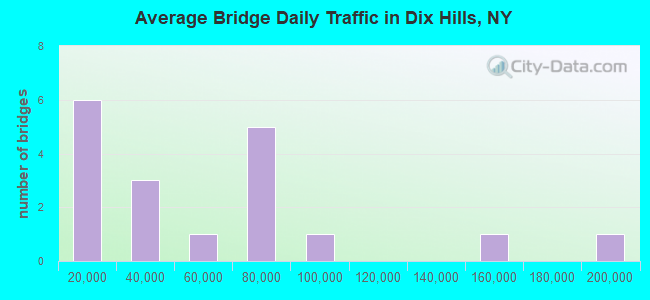
- 951,975Total average daily traffic
- 19,745Total average daily truck traffic
- National Bridge Inventory (NBI) Registered Bridges for Dix Hills
- No street view available for this location
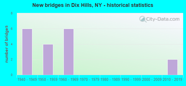
- New bridges - historical statistics
- 61940-1949
- 41950-1959
- 61960-1969
- 22010-2019
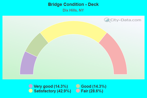
- Bridge Condition - Deck
- 14.3%Very good
- 14.3%Good
- 42.9%Satisfactory
- 28.6%Fair
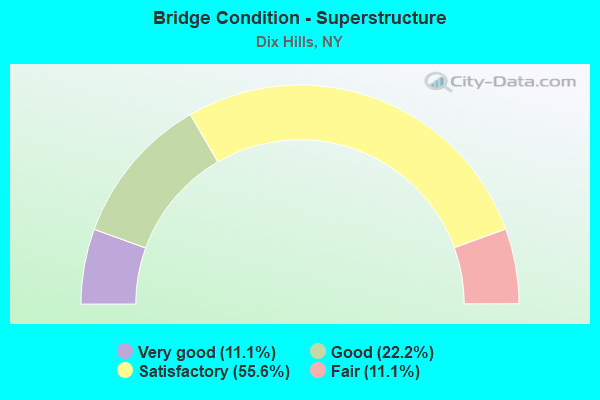
- Bridge Condition - Superstructure
- 11.1%Very good
- 22.2%Good
- 55.6%Satisfactory
- 11.1%Fair
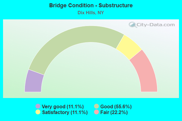
- Bridge Condition - Substructure
- 11.1%Very good
- 55.6%Good
- 11.1%Satisfactory
- 22.2%Fair
Find on map >> Show street view
Structure Number: 104933, Location: .6 MI W JCT RTS 231+495 (Lat: 40.793647, Lng: -73.352831), Route carried "on" structure: Other road , Year Built: 1963, Status: Open, Structure Length: 8.08m (26.51ft), Average Daily Traffic: 4,914 (year 2018), Truck Traffic: 3%, Average Future Daily Traffic: 6,080 (year 2040), Design Load: H 20, Features Intersected: 495I495I07031050 W/B, RT, Facility Carried by Structure: HALF HOLLOW RD
Minimum Vertical Clearance: 30+ m (98+ ft), Kilometerpoint: 5.326, Lanes on structure: 2, Lanes under structure: 8, Owner: State Highway Agency, Approaching Roadway Width: 8.5m (27.9ft), Skew: 2 degrees, Material/Design: Steel, Design/Construction: Stringer/Multi-beam, Number Of Spans In Main Unit: 4, Length of Maximum Span: 25.6m (84.0ft), Curb or Sidewalk Widths: Left: 1.5m (4.9ft), Right: 1.5m (4.9ft), Curb-To-Curb Width: 8.5m (27.9ft), Out-to-Out Width: 12.2m (40.0ft)
Condition: Deck: Good, Superstructure: Satisfactory, Substructure: Good, Operating Rating: 57.2 metric tons, Method Used To Determine Operating Rating: Load Factor (LF), Inventory Rating: 34.5 metric tons, Method Used To Determine Inventory Rating: Load Factor (LF), Structural Evaluation: Equal to present minimum criteria, Deck Geometry: Meets minimum limits, Underclear: High priority of corrective action, Approach Roadway Alignment: Better than present minimum criteria, Length Of Structure Improvement: 8.07m (26.48ft), Designated Inspection Frequency: Every 24 months, Inspection Date: Febuary 2020, Bridge Improvement Cost: $3,760,000, Roadway Improvement Cost: $2,202,000, Total Project Cost: $5,962,000 ( Estimate for 2021), Deck Structure Type: Concrete Cast-file-Place, Wearing Surface/Protective System: Wearing Surface: Bituminous
Find on map >> Show street view
Structure Number: 1049341, Location: JCT I495 & SH 231 (Lat: 40.797606, Lng: -73.342181), Route carried "on" structure: Interstate 495, Year Built: 1963, Status: Open, Structure Length: 6.25m (20.51ft), Average Daily Traffic: 80,648 (year 2002), Truck Traffic: 13%, Design Load: HS 20+Mod, Features Intersected: 231 231 07011072 NB, RTE
Minimum Vertical Clearance: 30+ m (98+ ft), Kilometerpoint: 8.994, Lanes on structure: 4, Lanes under structure: 7, Base Highway Network: Yes, Owner: State Highway Agency, Approaching Roadway Width: 21.0m (68.9ft), Skew: 2 degrees, Material/Design: Steel, Design/Construction: Stringer/Multi-beam, Number Of Spans In Main Unit: 4, Length of Maximum Span: 21.3m (69.9ft), Curb-To-Curb Width: 21.0m (68.9ft), Out-to-Out Width: 21.9m (71.9ft)
Condition: Deck: Fair, Superstructure: Satisfactory, Substructure: Fair, Operating Rating: 69.9 metric tons, Method Used To Determine Operating Rating: Load Factor (LF), Inventory Rating: 33.6 metric tons, Method Used To Determine Inventory Rating: Load Factor (LF), Structural Evaluation: Somewhat better than minimum adequacy, Deck Geometry: Better than present minimum criteria, Underclear: Meets minimum limits, Approach Roadway Alignment: Equal to present desirable criteria, Length Of Structure Improvement: 6.24m (20.47ft), Designated Inspection Frequency: Every 24 months, Inspection Date: August 2020, Bridge Improvement Cost: $5,248,000, Roadway Improvement Cost: $3,073,000, Total Project Cost: $8,322,000 ( Estimate for 2021), Deck Structure Type: Concrete Cast-file-Place, Wearing Surface/Protective System: Wearing Surface: Integral Concrete
Find on map >> Show street view
Structure Number: 1049342, Location: JCT I495 & SH 231 (Lat: 40.797317, Lng: -73.342136), Route carried "on" structure: Interstate 495, Year Built: 1963, Status: Open, Structure Length: 6.25m (20.51ft), Average Daily Traffic: 73,249 (year 2018), Truck Traffic: 10%, Average Future Daily Traffic: 76,911 (year 2040), Design Load: HS 20+Mod, Features Intersected: 231 231 07011072, RTE 23
Minimum Vertical Clearance: 30+ m (98+ ft), Kilometerpoint: 9.010, Lanes on structure: 4, Lanes under structure: 7, Base Highway Network: Yes, Owner: State Highway Agency, Approaching Roadway Width: 20.7m (67.9ft), Skew: 2 degrees, Material/Design: Steel, Design/Construction: Stringer/Multi-beam, Number Of Spans In Main Unit: 4, Length of Maximum Span: 21.3m (69.9ft), Curb-To-Curb Width: 20.9m (68.6ft), Out-to-Out Width: 21.9m (71.9ft)
Condition: Deck: Fair, Superstructure: Fair, Substructure: Fair, Operating Rating: 69.9 metric tons, Method Used To Determine Operating Rating: Load Factor (LF), Inventory Rating: 33.6 metric tons, Method Used To Determine Inventory Rating: Load Factor (LF), Structural Evaluation: Somewhat better than minimum adequacy, Deck Geometry: Better than present minimum criteria, Underclear: Meets minimum limits, Approach Roadway Alignment: Equal to present desirable criteria, Length Of Structure Improvement: 6.24m (20.47ft), Designated Inspection Frequency: Every 24 months, Inspection Date: July 2020, Bridge Improvement Cost: $5,248,000, Roadway Improvement Cost: $3,073,000, Total Project Cost: $8,322,000 ( Estimate for 2021), Deck Structure Type: Concrete Cast-file-Place, Wearing Surface/Protective System: Wearing Surface: Integral Concrete
Find on map >> Show street view
Structure Number: 104935, Location: 1.2 MI E JCT RTS 231+495 (Lat: 40.803314, Lng: -73.320186), Route carried "on" structure: Other road , Year Built: 2015, Status: Open, Structure Length: 5.39m (17.68ft), Average Daily Traffic: 3,851 (year 2020), Truck Traffic: 6%, Average Future Daily Traffic: 4,678 (year 2040), Design Load: HL 93, Features Intersected: 495I495I07031069, WB, RT, Facility Carried by Structure: CARLLS STRGT PATH
Minimum Vertical Clearance: 30+ m (98+ ft), Kilometerpoint: 2.671, Lanes on structure: 3, Lanes under structure: 9, Owner: State Highway Agency, Approaching Roadway Width: 13.1m (43.0ft), Material/Design: Prestressed concrete, Design/Construction: Box Beam or Girders - Multiple, Number Of Spans In Main Unit: 2, Length of Maximum Span: 26.5m (86.9ft), Curb or Sidewalk Widths: Left: 0.0m, Right: 1.7m (5.6ft), Curb-To-Curb Width: 13.1m (43.0ft), Out-to-Out Width: 15.7m (51.5ft)
Condition: Deck: Very good, Superstructure: Very good, Substructure: Very good, Operating Rating: 46.3 metric tons, Method Used To Determine Operating Rating: Load and Resistance Factor Rating (LRFR) rating reported by rating factor(RF) method using HL-93 loadings, Inventory Rating: 35.6 metric tons, Method Used To Determine Inventory Rating: Load and Resistance Factor Rating (LRFR) rating reported by rating factor(RF) method using HL-93 loadings, Structural Evaluation: Equal to present desirable criteria, Deck Geometry: Meets minimum limits, Underclear: High priority of corrective action, Approach Roadway Alignment: Equal to present desirable criteria, Length Of Structure Improvement: 5.39m (17.68ft), Designated Inspection Frequency: Every 24 months, Inspection Date: November 2021, Bridge Improvement Cost: $3,093,000, Roadway Improvement Cost: $1,811,000, Total Project Cost: $4,904,000 ( Estimate for 2021), Deck Structure Type: Concrete Cast-file-Place, Wearing Surface/Protective System: Wearing Surface: Integral Concrete, Deck Protection: Epoxy Coated Reinforcing
Find on map >> Show street view
Structure Number: 105737, Location: 1.1 MI W JCT SH 231 & NSP (Lat: 40.825328, Lng: -73.364508), Route carried "on" structure: Other road , Year Built: 1949, Status: Open, Structure Length: 1.49m (4.89ft), Average Daily Traffic: 2,564 (year 2019), Truck Traffic: 2%, Average Future Daily Traffic: 3,590 (year 2039), Design Load: H 20, Features Intersected: RTE 908G, Facility Carried by Structure: DIX HILLS ROAD
Minimum Vertical Clearance: 30+ m (98+ ft), Kilometerpoint: 0.740, Lanes on structure: 2, Lanes under structure: 2, Owner: State Highway Agency, Approaching Roadway Width: 7.3m (24.0ft), Skew: 1 degrees, Material/Design: Concrete, Design/Construction: Arch - Deck, Number Of Spans In Main Unit: 1, Length of Maximum Span: 13.4m (44.0ft), Curb or Sidewalk Widths: Left: 2.4m (7.9ft), Right: 2.4m (7.9ft), Curb-To-Curb Width: 7.3m (24.0ft), Out-to-Out Width: 13.1m (43.0ft)
Condition: Superstructure: Good, Substructure: Good, Operating Rating: 58.3 metric tons, Method Used To Determine Operating Rating: Field evaluation and documented engineering judgment, Inventory Rating: 24.1 metric tons, Method Used To Determine Inventory Rating: Field evaluation and documented engineering judgment, Structural Evaluation: Equal to present minimum criteria, Deck Geometry: High priority of replacement, Underclear: High priority of corrective action, Approach Roadway Alignment: Better than present minimum criteria, Length Of Structure Improvement: 1.49m (4.89ft), Designated Inspection Frequency: Every 24 months, Inspection Date: January 2020, Bridge Improvement Cost: $600,000, Roadway Improvement Cost: $351,000, Total Project Cost: $951,000 ( Estimate for 2021)
Find on map >> Show street view
Structure Number: 105837, Location: 1.1 MI W JCT RTS 231+NSP (Lat: 40.825161, Lng: -73.364381), Route carried "on" structure: Other road , Year Built: 1949, Status: Open, Structure Length: 1.49m (4.89ft), Average Daily Traffic: 2,564 (year 2019), Truck Traffic: 2%, Average Future Daily Traffic: 3,172 (year 2040), Design Load: H 20, Features Intersected: RTE 908G, Facility Carried by Structure: DIX HILLS ROAD
Minimum Vertical Clearance: 30+ m (98+ ft), Kilometerpoint: 0.708, Lanes on structure: 2, Lanes under structure: 2, Owner: State Highway Agency, Approaching Roadway Width: 7.3m (24.0ft), Skew: 1 degrees, Material/Design: Concrete, Design/Construction: Arch - Deck, Number Of Spans In Main Unit: 1, Length of Maximum Span: 13.4m (44.0ft), Curb or Sidewalk Widths: Left: 2.4m (7.9ft), Right: 2.4m (7.9ft), Curb-To-Curb Width: 7.3m (24.0ft), Out-to-Out Width: 13.1m (43.0ft)
Condition: Superstructure: Good, Substructure: Good, Operating Rating: 58.3 metric tons, Method Used To Determine Operating Rating: Field evaluation and documented engineering judgment, Inventory Rating: 24.1 metric tons, Method Used To Determine Inventory Rating: Field evaluation and documented engineering judgment, Structural Evaluation: Equal to present minimum criteria, Deck Geometry: High priority of replacement, Underclear: High priority of corrective action, Approach Roadway Alignment: Better than present minimum criteria, Length Of Structure Improvement: 1.49m (4.89ft), Designated Inspection Frequency: Every 24 months, Inspection Date: January 2020, Bridge Improvement Cost: $600,000, Roadway Improvement Cost: $351,000, Total Project Cost: $951,000 ( Estimate for 2021)
Find on map >> Show street view
Structure Number: 1058399, Location: JCT NSP + RTE 231 (Lat: 40.823489, Lng: -73.343403), Route carried "on" structure: State highway 908G, Year Built: 1950, Status: Open, Structure Length: 2.26m (7.41ft), Average Daily Traffic: 70,309 (year 2020), Truck Traffic: 1%, Average Future Daily Traffic: 83,632 (year 2040), Design Load: H 20, Features Intersected: RTE 231
Minimum Vertical Clearance: 30+ m (98+ ft), Kilometerpoint: 10.796, Lanes on structure: 5, Lanes under structure: 4, Base Highway Network: Yes, Owner: State Highway Agency, Approaching Roadway Width: 21.9m (71.9ft), Skew: 22 degrees, Material/Design: Concrete, Design/Construction: Frame, Number Of Spans In Main Unit: 1, Length of Maximum Span: 19.5m (64.0ft), Curb-To-Curb Width: 21.8m (71.5ft), Out-to-Out Width: 24.1m (79.1ft)
Condition: Deck: Satisfactory, Superstructure: Satisfactory, Substructure: Good, Operating Rating: 58.0 metric tons, Method Used To Determine Operating Rating: Field evaluation and documented engineering judgment, Inventory Rating: 22.9 metric tons, Method Used To Determine Inventory Rating: Field evaluation and documented engineering judgment, Structural Evaluation: Somewhat better than minimum adequacy, Deck Geometry: Meets minimum limits, Underclear: Meets minimum limits, Approach Roadway Alignment: Equal to present desirable criteria, Length Of Structure Improvement: 2.25m (7.38ft), Designated Inspection Frequency: Every 24 months, Inspection Date: January 2020, Bridge Improvement Cost: $3,365,000, Roadway Improvement Cost: $1,971,000, Total Project Cost: $5,336,000 ( Estimate for 2021), Wearing Surface/Protective System: Wearing Surface: Monolithic Concrete
Find on map >> Show street view
Structure Number: 1058409, Location: 2.6 MI E JCT RTS 231+NSP (Lat: 40.818558, Lng: -73.293583), Route carried "on" structure: State highway 908G, Year Built: 1951, Status: Open, Structure Length: 2.16m (7.09ft), Average Daily Traffic: 70,309 (year 2019), Truck Traffic: 1%, Average Future Daily Traffic: 83,632 (year 2040), Design Load: H 20, Features Intersected: COMMACK ROAD
Minimum Vertical Clearance: 30+ m (98+ ft), Kilometerpoint: 15.398, Lanes on structure: 6, Lanes under structure: 4, Base Highway Network: Yes, Owner: State Highway Agency, Approaching Roadway Width: 25.9m (85.0ft), Skew: 20 degrees, Material/Design: Concrete, Design/Construction: Frame, Number Of Spans In Main Unit: 1, Length of Maximum Span: 18.8m (61.7ft), Curb-To-Curb Width: 25.8m (84.6ft), Out-to-Out Width: 28.0m (91.9ft)
Condition: Deck: Satisfactory, Superstructure: Satisfactory, Substructure: Satisfactory, Operating Rating: 57.3 metric tons, Method Used To Determine Operating Rating: Field evaluation and documented engineering judgment, Inventory Rating: 22.7 metric tons, Method Used To Determine Inventory Rating: Field evaluation and documented engineering judgment, Structural Evaluation: Somewhat better than minimum adequacy, Deck Geometry: Meets minimum limits, Underclear: Meets minimum limits, Approach Roadway Alignment: Equal to present desirable criteria, Length Of Structure Improvement: 2.16m (7.09ft), Designated Inspection Frequency: Every 24 months, Inspection Date: Febuary 2020, Bridge Improvement Cost: $3,785,000, Roadway Improvement Cost: $2,217,000, Total Project Cost: $6,002,000 ( Estimate for 2021), Wearing Surface/Protective System: Wearing Surface: Monolithic Concrete
Find on map >> Show street view
Structure Number: 205838, Location: 2.2 MI NE JCT SH 231 + I4 (Lat: 40.825542, Lng: -73.364686), Route carried "on" structure: Other road , Year Built: 1949, Status: Open, Structure Length: 2.16m (7.09ft), Average Daily Traffic: 2,564 (year 2019), Truck Traffic: 2%, Average Future Daily Traffic: 3,590 (year 2039), Design Load: H 20, Features Intersected: OLD COUNTRY RD, Facility Carried by Structure: DIX HILLS ROAD
Minimum Vertical Clearance: 30+ m (98+ ft), Kilometerpoint: 0.772, Lanes on structure: 2, Lanes under structure: 2, Owner: State Highway Agency, Maintenance Responsibility: Town or Township Highway Agency, Approaching Roadway Width: 7.3m (24.0ft), Skew: 1 degrees, Material/Design: Concrete, Design/Construction: Frame, Number Of Spans In Main Unit: 1, Length of Maximum Span: 19.2m (63.0ft), Curb or Sidewalk Widths: Left: 2.2m (7.2ft), Right: 2.1m (6.9ft), Curb-To-Curb Width: 7.3m (24.0ft), Out-to-Out Width: 13.1m (43.0ft)
Condition: Deck: Satisfactory, Superstructure: Satisfactory, Substructure: Good, Operating Rating: 57.6 metric tons, Method Used To Determine Operating Rating: Field evaluation and documented engineering judgment, Inventory Rating: 22.8 metric tons, Method Used To Determine Inventory Rating: Field evaluation and documented engineering judgment, Structural Evaluation: Equal to present minimum criteria, Deck Geometry: High priority of replacement, Underclear: High priority of corrective action, Approach Roadway Alignment: Equal to present desirable criteria, Length Of Structure Improvement: 2.16m (7.09ft), Designated Inspection Frequency: Every 24 months, Inspection Date: April 2020, Bridge Improvement Cost: $1,878,000, Roadway Improvement Cost: $1,100,000, Total Project Cost: $2,978,000 ( Estimate for 2021), Deck Structure Type: Concrete Cast-file-Place, Wearing Surface/Protective System: Wearing Surface: Bituminous
Find on map >> Show street view
Structure Number: 104933, Location: .6 MI W JCT RTS 231+495 (Lat: 40.793647, Lng: -73.352831), Route carried "under" structure: Interstate 495, Year Built: 1963, Structure Length: 0. m, Average Daily Traffic: 197,421 (year 2002), Features Intersected: 495I495I07031050 W/B, RT, Facility Carried by Structure: HALF HOLLOW RD
Minimum Vertical Clearance: 4.88m (16.01ft), Kilometerpoint: 8.045, Lanes on structure: 2, Lanes under structure: 4, Material/Design: Steel, Design/Construction: Stringer/Multi-beam, Length of Maximum Span: 25.6m (84.0ft)
Find on map >> Show street view
Structure Number: 1049341, Location: JCT I495 & SH 231 (Lat: 40.797606, Lng: -73.342181), Route carried "under" structure: State highway 231, Year Built: 1963, Structure Length: 0. m, Average Daily Traffic: 31,376 (year 2002), Features Intersected: 231 231 07011072 NB, RTE, Facility Carried by Structure: RTE I495
Minimum Vertical Clearance: 4.52m (14.83ft), Kilometerpoint: 11.778, Lanes on structure: 4, Lanes under structure: 3, Material/Design: Steel, Design/Construction: Stringer/Multi-beam, Length of Maximum Span: 21.3m (69.9ft)
Find on map >> Show street view
Structure Number: 1049342, Location: JCT I495 & SH 231 (Lat: 40.797317, Lng: -73.342136), Route carried "under" structure: State highway 231, Year Built: 1963, Structure Length: 0. m, Average Daily Traffic: 31,376 (year 2002), Features Intersected: 231 231 07011072, RTE 23, Facility Carried by Structure: RTE I495
Minimum Vertical Clearance: 4.50m (14.76ft), Kilometerpoint: 11.778, Lanes on structure: 4, Lanes under structure: 3, Material/Design: Steel, Design/Construction: Stringer/Multi-beam, Length of Maximum Span: 21.3m (69.9ft)
Find on map >> Show street view
Structure Number: 104935, Location: 1.2 MI E JCT RTS 231+495 (Lat: 40.803314, Lng: -73.320186), Route carried "under" structure: Interstate 495, Year Built: 2015, Structure Length: 0. m, Average Daily Traffic: 155,816 (year 2002), Features Intersected: 495I495I07031069, WB, RT, Facility Carried by Structure: CARLLS STRGT PATH
Minimum Vertical Clearance: 4.72m (15.49ft), Kilometerpoint: 11.038, Lanes on structure: 3, Lanes under structure: 5, Material/Design: Prestressed concrete, Design/Construction: Box Beam or Girders - Multiple, Length of Maximum Span: 26.5m (86.9ft)
Find on map >> Show street view
Structure Number: 105737, Location: 1.1 MI W JCT SH 231 & NSP (Lat: 40.825328, Lng: -73.364508), Route carried "under" structure: State highway 908G, Year Built: 1949, Structure Length: 0. m, Average Daily Traffic: 71,543 (year 2002), Features Intersected: RTE 908G, Facility Carried by Structure: DIX HILLS ROAD
Minimum Vertical Clearance: 3.78m (12.40ft), Kilometerpoint: 7.273, Lanes on structure: 2, Lanes under structure: 2, Material/Design: Concrete, Design/Construction: Arch - Deck, Length of Maximum Span: 13.4m (44.0ft)
Find on map >> Show street view
Structure Number: 105837, Location: 1.1 MI W JCT RTS 231+NSP (Lat: 40.825161, Lng: -73.364381), Route carried "under" structure: State highway 908G, Year Built: 1949, Structure Length: 0. m, Average Daily Traffic: 71,543 (year 2002), Features Intersected: RTE 908G, Facility Carried by Structure: DIX HILLS ROAD
Minimum Vertical Clearance: 3.78m (12.40ft), Kilometerpoint: 7.273, Lanes on structure: 2, Lanes under structure: 2, Material/Design: Concrete, Design/Construction: Arch - Deck, Length of Maximum Span: 13.4m (44.0ft)
Find on map >> Show street view
Structure Number: 1058399, Location: JCT NSP + RTE 231 (Lat: 40.823489, Lng: -73.343403), Route carried "under" structure: State highway 231, Year Built: 1950, Structure Length: 0. m, Average Daily Traffic: 31,376 (year 2002), Features Intersected: RTE 231, Facility Carried by Structure: RTE 908G
Minimum Vertical Clearance: 4.67m (15.32ft), Kilometerpoint: 14.481, Lanes on structure: 5, Lanes under structure: 4, Material/Design: Concrete, Design/Construction: Frame, Length of Maximum Span: 19.5m (64.0ft)
Find on map >> Show street view
Structure Number: 1058409, Location: 2.6 MI E JCT RTS 231+NSP (Lat: 40.818558, Lng: -73.293583), Route carried "under" structure: County highway , Year Built: 1951, Structure Length: 0. m, Average Daily Traffic: 43,052 (year 2005), Features Intersected: COMMACK ROAD, Facility Carried by Structure: RTE 908G
Minimum Vertical Clearance: 4.67m (15.32ft), Kilometerpoint: 0.000, Lanes on structure: 6, Lanes under structure: 4, Material/Design: Concrete, Design/Construction: Frame, Length of Maximum Span: 18.8m (61.7ft)
Find on map >> Show street view
Structure Number: 205838, Location: 2.2 MI NE JCT SH 231 + I4 (Lat: 40.825542, Lng: -73.364686), Route carried "under" structure: Other road , Year Built: 1949, Structure Length: 0. m, Average Daily Traffic: 7,500 (year 2021), Features Intersected: OLD COUNTRY RD, Facility Carried by Structure: DIX HILLS ROAD
Minimum Vertical Clearance: 4.27m (14.01ft), Kilometerpoint: 0.000, Lanes on structure: 2, Lanes under structure: 2, Material/Design: Concrete, Design/Construction: Frame, Length of Maximum Span: 19.2m (63.0ft)