Bridge Statistics for Deltona, Florida (FL)
Condition, Traffic, Stress, Structural Evaluation, Project Costs
- National Bridge Inventory (NBI) Statistics
- 16Number of bridges
- 184ft / 56.1mTotal length
- $168,000Total costs
- 480,943Total average daily traffic
- 50,580Total average daily truck traffic
- National Bridge Inventory (NBI) Registered Bridges for Deltona
- No street view available for this location
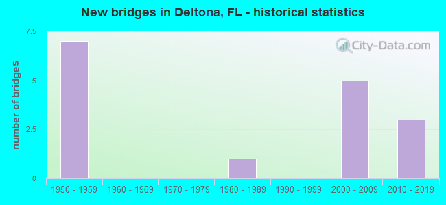
- New bridges - historical statistics
- 71950-1959
- 11980-1989
- 52000-2009
- 32010-2019

- Reconstructed bridges - Historical Statistics
- 21990-1999
- 22000-2009


- Bridge Condition - Deck
- 11.1%Very good
- 44.4%Good
- 44.4%Satisfactory

- Bridge Condition - Superstructure
- 11.1%Very good
- 55.6%Good
- 33.3%Satisfactory

- Bridge Condition - Substructure
- 11.1%Very good
- 77.8%Good
- 11.1%Satisfactory

- Bridge Condition - Channel
- 50.0%Very good
- 25.0%Good
- 25.0%Satisfactory
Find on map >> Show street view
Structure Number: 790033, Location: SR-415 - Deep Creek (Lat: 28.899928, Lng: -81.134083), Route carried "on" structure: State highway 415, Year Built: 1957, Year Reconstructed: 2000, Status: Open, Structure Length: 3.72m (12.20ft), Average Daily Traffic: 10,200 (year 2020), Truck Traffic: 10%, Average Future Daily Traffic: 17,697 (year 2042), Design Load: H 20, Features Intersected: Deep Creek
Minimum Vertical Clearance: 30+ m (98+ ft), Kilometerpoint: 14.204, Lanes on structure: 2, Owner: State Highway Agency, Approaching Roadway Width: 9.7m (31.8ft), Material/Design: Concrete, Design/Construction: Slab, Number Of Spans In Main Unit: 6, Length of Maximum Span: 6.1m (20.0ft), Curb-To-Curb Width: 13.2m (43.3ft), Out-to-Out Width: 14.1m (46.3ft)
Condition: Deck: Satisfactory, Superstructure: Satisfactory, Substructure: Good, Channel: Satisfactory, Operating Rating: 45.5 metric tons, Method Used To Determine Operating Rating: Load Factor (LF), Inventory Rating: 27.3 metric tons, Method Used To Determine Inventory Rating: Load Factor (LF), Structural Evaluation: Equal to present minimum criteria, Deck Geometry: Somewhat better than minimum adequacy, Waterway Adequacy: Equal to present desirable criteria, Approach Roadway Alignment: Equal to present desirable criteria, Length Of Structure Improvement: 3.66m (12.01ft), Designated Inspection Frequency: Every 24 months, Underwater Inspection Frequency: Every 24 months, Inspection Date: March 2020, Underwater Inspection Date: March 2020, Bridge Improvement Cost: $132,000, Total Project Cost: $168,000, Deck Structure Type: Concrete Cast-file-Place, Wearing Surface/Protective System: Wearing Surface: Monolithic Concrete
Find on map >> Show street view
Structure Number: 790042, Location: I-4 WB - Dirksen Drive (Lat: 28.871614, Lng: -81.284528), Route carried "on" structure: Interstate 4, Year Built: 1959, Year Reconstructed: 2004, Status: Open, Structure Length: 10.07m (33.04ft), Average Daily Traffic: 52,000 (year 2020), Truck Traffic: 10%, Average Future Daily Traffic: 90,220 (year 2042), Design Load: HS 20, Features Intersected: Dirksen Drive
Minimum Vertical Clearance: 30+ m (98+ ft), Kilometerpoint: 5.626, Lanes on structure: 4, Lanes under structure: 4, Base Highway Network: Yes, Owner: State Highway Agency, Approaching Roadway Width: 18.9m (62.0ft), Skew: 3 degrees, Material/Design: Prestressed concrete, Design/Construction: Stringer/Multi-beam, Number Of Spans In Main Unit: 5, Length of Maximum Span: 22.5m (73.8ft), Curb-To-Curb Width: 19.5m (64.0ft), Out-to-Out Width: 20.4m (66.9ft)
Condition: Deck: Satisfactory, Superstructure: Good, Substructure: Good, Operating Rating: 54.2 metric tons, Method Used To Determine Operating Rating: Load Factor (LF), Inventory Rating: 32.7 metric tons, Method Used To Determine Inventory Rating: Load Factor (LF), Structural Evaluation: Better than present minimum criteria, Deck Geometry: Better than present minimum criteria, Underclear: Meets minimum limits, Approach Roadway Alignment: Equal to present desirable criteria, Designated Inspection Frequency: Every 24 months, Inspection Date: November 2020, Deck Structure Type: Concrete Cast-file-Place, Wearing Surface/Protective System: Wearing Surface: Monolithic Concrete
Find on map >> Show street view
Structure Number: 790053, Location: SR-472 EB over I-4 (Lat: 28.955133, Lng: -81.257722), Route carried "on" structure: State highway 472, Year Built: 1959, Status: Open, Structure Length: 6.70m (21.98ft), Average Daily Traffic: 14,250 (year 2020), Truck Traffic: 6%, Average Future Daily Traffic: 24,724 (year 2042), Design Load: HS 20+Mod, Features Intersected: I-4
Minimum Vertical Clearance: 30+ m (98+ ft), Kilometerpoint: 5.258, Lanes on structure: 2, Lanes under structure: 6, Owner: State Highway Agency, Approaching Roadway Width: 12.1m (39.7ft), Skew: 2 degrees, Material/Design: Prestressed concrete, Design/Construction: Stringer/Multi-beam, Number Of Spans In Main Unit: 4, Length of Maximum Span: 21.9m (71.9ft), Curb-To-Curb Width: 12.1m (39.7ft), Out-to-Out Width: 13.8m (45.3ft)
Condition: Deck: Satisfactory, Superstructure: Good, Substructure: Satisfactory, Operating Rating: 56.0 metric tons, Method Used To Determine Operating Rating: Load Factor (LF), Inventory Rating: 48.7 metric tons, Method Used To Determine Inventory Rating: Load Factor (LF), Structural Evaluation: Equal to present minimum criteria, Deck Geometry: Better than present minimum criteria, Underclear: High priority of corrective action, Approach Roadway Alignment: Equal to present desirable criteria, Designated Inspection Frequency: Every 24 months, Inspection Date: November 2020, Deck Structure Type: Concrete Cast-file-Place, Wearing Surface/Protective System: Wearing Surface: Monolithic Concrete
Find on map >> Show street view
Structure Number: 7901, Location: I-4 EB - Dirksen Dr (Lat: 28.871669, Lng: -81.284233), Route carried "on" structure: Interstate 4, Year Built: 1959, Year Reconstructed: 2004, Status: Open, Structure Length: 10.06m (33.01ft), Average Daily Traffic: 52,000 (year 2020), Truck Traffic: 10%, Average Future Daily Traffic: 90,220 (year 2042), Design Load: HS 20, Features Intersected: Dirksen Dr
Minimum Vertical Clearance: 30+ m (98+ ft), Kilometerpoint: 5.634, Lanes on structure: 3, Lanes under structure: 4, Base Highway Network: Yes, Owner: State Highway Agency, Approaching Roadway Width: 18.0m (59.1ft), Skew: 3 degrees, Material/Design: Prestressed concrete, Design/Construction: Stringer/Multi-beam, Number Of Spans In Main Unit: 5, Length of Maximum Span: 22.5m (73.8ft), Curb-To-Curb Width: 17.1m (56.1ft), Out-to-Out Width: 18.0m (59.1ft)
Condition: Deck: Satisfactory, Superstructure: Satisfactory, Substructure: Good, Operating Rating: 54.2 metric tons, Method Used To Determine Operating Rating: Load Factor (LF), Inventory Rating: 32.7 metric tons, Method Used To Determine Inventory Rating: Load Factor (LF), Structural Evaluation: Equal to present minimum criteria, Deck Geometry: Superior to present desirable criteria, Underclear: Meets minimum limits, Approach Roadway Alignment: Equal to present desirable criteria, Designated Inspection Frequency: Every 24 months, Inspection Date: November 2020, Deck Structure Type: Concrete Cast-file-Place, Wearing Surface/Protective System: Wearing Surface: Monolithic Concrete
Find on map >> Show street view
Structure Number: 79019, Location: SR-472 WB over I-4 (Lat: 28.955358, Lng: -81.257686), Route carried "on" structure: State highway 472, Year Built: 2000, Status: Open, Structure Length: 6.60m (21.65ft), Average Daily Traffic: 14,250 (year 2020), Truck Traffic: 6%, Average Future Daily Traffic: 24,724 (year 2042), Design Load: HS 20+Mod, Features Intersected: I-4
Minimum Vertical Clearance: 30+ m (98+ ft), Kilometerpoint: 5.250, Lanes on structure: 3, Lanes under structure: 6, Owner: State Highway Agency, Approaching Roadway Width: 14.6m (47.9ft), Skew: 1 degrees, Material/Design: Prestressed concrete, Design/Construction: Stringer/Multi-beam, Number Of Spans In Main Unit: 4, Length of Maximum Span: 21.6m (70.9ft), Curb or Sidewalk Widths: Left: 1.5m (4.9ft), Right: 0.0m, Curb-To-Curb Width: 14.6m (47.9ft), Out-to-Out Width: 17.3m (56.8ft)
Condition: Deck: Good, Superstructure: Good, Substructure: Good, Operating Rating: 62.1 metric tons, Method Used To Determine Operating Rating: Load Factor (LF), Inventory Rating: 38.6 metric tons, Method Used To Determine Inventory Rating: Load Factor (LF), Structural Evaluation: Better than present minimum criteria, Deck Geometry: Somewhat better than minimum adequacy, Underclear: Meets minimum limits, Approach Roadway Alignment: Equal to present desirable criteria, Designated Inspection Frequency: Every 24 months, Inspection Date: November 2020, Deck Structure Type: Concrete Cast-file-Place, Wearing Surface/Protective System: Wearing Surface: Monolithic Concrete
Find on map >> Show street view
Structure Number: 790191, Location: Enterprise Rd. Over I-4 (Lat: 28.887019, Lng: -81.279375), Route carried "on" structure: County highway , Year Built: 2003, Year Reconstructed: 2005, Status: Open, Structure Length: 9.19m (30.15ft), Average Daily Traffic: 6,480 (year 2007), Truck Traffic: 1%, Average Future Daily Traffic: 11,243 (year 2033), Design Load: HL 93, Features Intersected: I-4, Facility Carried by Structure: Enterprise Rd.
Minimum Vertical Clearance: 30+ m (98+ ft), Kilometerpoint: 4.619, Lanes on structure: 4, Lanes under structure: 6, Owner: State Highway Agency, Approaching Roadway Width: 18.0m (59.1ft), Skew: 25 degrees, Material/Design: Prestressed concrete, Design/Construction: Stringer/Multi-beam, Number Of Spans In Main Unit: 2, Length of Maximum Span: 45.7m (149.9ft), Curb or Sidewalk Widths: Left: 1.5m (4.9ft), Right: 0.0m, Curb-To-Curb Width: 18.0m (59.1ft), Out-to-Out Width: 23.4m (76.8ft)
Condition: Deck: Good, Superstructure: Satisfactory, Substructure: Good, Inventory Rating: 54.1 metric tons, Method Used To Determine Inventory Rating: Load Factor (LF), Structural Evaluation: Equal to present minimum criteria, Deck Geometry: Somewhat better than minimum adequacy, Underclear: Equal to present minimum criteria, Approach Roadway Alignment: Equal to present desirable criteria, Designated Inspection Frequency: Every 24 months, Inspection Date: November 2020, Deck Structure Type: Concrete Cast-file-Place, Wearing Surface/Protective System: Wearing Surface: Monolithic Concrete
Find on map >> Show street view
Structure Number: 790198, Location: SR-415 - St Johns Relief (Lat: 28.815553, Lng: -81.190525), Route carried "on" structure: State highway 415, Year Built: 2003, Status: Open, Structure Length: 3.75m (12.30ft), Average Daily Traffic: 11,500 (year 2020), Truck Traffic: 10%, Average Future Daily Traffic: 19,952 (year 2042), Features Intersected: St Johns River Relief
Minimum Vertical Clearance: 30+ m (98+ ft), Kilometerpoint: 2.826, Lanes on structure: 2, Owner: State Highway Agency, Approaching Roadway Width: 10.5m (34.4ft), Material/Design: Concrete continuous, Design/Construction: Slab, Number Of Spans In Main Unit: 4, Length of Maximum Span: 9.3m (30.5ft), Curb-To-Curb Width: 13.4m (44.0ft), Out-to-Out Width: 14.4m (47.2ft)
Condition: Deck: Good, Superstructure: Good, Substructure: Good, Channel: Very good, Operating Rating: 69.2 metric tons, Method Used To Determine Operating Rating: Load Factor (LF), Inventory Rating: 41.5 metric tons, Method Used To Determine Inventory Rating: Load Factor (LF), Structural Evaluation: Better than present minimum criteria, Deck Geometry: Superior to present desirable criteria, Waterway Adequacy: Equal to present desirable criteria, Approach Roadway Alignment: Equal to present desirable criteria, Designated Inspection Frequency: Every 24 months, Underwater Inspection Frequency: Every 24 months, Inspection Date: June 2021, Underwater Inspection Date: June 2021, Deck Structure Type: Concrete Cast-file-Place, Wearing Surface/Protective System: Wearing Surface: Monolithic Concrete
Find on map >> Show street view
Structure Number: 79022, Location: SR-415 -St. Johns Relief (Lat: 28.815631, Lng: -81.190639), Route carried "on" structure: State highway 415, Year Built: 2014, Status: Open, Structure Length: 3.69m (12.11ft), Average Daily Traffic: 11,500 (year 2020), Truck Traffic: 10%, Average Future Daily Traffic: 19,952 (year 2042), Design Load: HL 93, Features Intersected: St. Johns River Relief
Minimum Vertical Clearance: 30+ m (98+ ft), Kilometerpoint: 2.826, Lanes on structure: 2, Owner: State Highway Agency, Approaching Roadway Width: 9.3m (30.5ft), Material/Design: Concrete continuous, Design/Construction: Slab, Number Of Spans In Main Unit: 4, Length of Maximum Span: 9.3m (30.5ft), Curb-To-Curb Width: 12.2m (40.0ft), Out-to-Out Width: 13.1m (43.0ft)
Condition: Deck: Very good, Superstructure: Very good, Substructure: Very good, Channel: Very good, Operating Rating: 47.4 metric tons, Method Used To Determine Operating Rating: Load and Resistance Factor (LRFR), Inventory Rating: 36.6 metric tons, Method Used To Determine Inventory Rating: Load and Resistance Factor (LRFR), Structural Evaluation: Equal to present desirable criteria, Deck Geometry: Better than present minimum criteria, Waterway Adequacy: Equal to present desirable criteria, Approach Roadway Alignment: Equal to present desirable criteria, Designated Inspection Frequency: Every 24 months, Underwater Inspection Frequency: Every 24 months, Inspection Date: June 2021, Underwater Inspection Date: June 2021, Deck Structure Type: Concrete Cast-file-Place, Wearing Surface/Protective System: Wearing Surface: Monolithic Concrete
Find on map >> Show street view
Structure Number: 794139, Location: 3.8 Mi. East of SR-415 (Lat: 28.846075, Lng: -81.101772), Route carried "on" structure: County highway , Year Built: 1985, Status: Open, Structure Length: 2.29m (7.51ft), Average Daily Traffic: 463 (year 2020), Truck Traffic: 5%, Average Future Daily Traffic: 560 (year 2042), Design Load: HS 20, Features Intersected: Deep Ck. Diversion Cnl, Facility Carried by Structure: Maytown Road
Minimum Vertical Clearance: 30+ m (98+ ft), Kilometerpoint: 6.114, Lanes on structure: 2, Owner: County Highway Agency, Approaching Roadway Width: 10.4m (34.1ft), Material/Design: Concrete continuous, Design/Construction: Slab, Number Of Spans In Main Unit: 3, Length of Maximum Span: 7.6m (24.9ft), Curb-To-Curb Width: 10.4m (34.1ft), Out-to-Out Width: 11.2m (36.7ft)
Condition: Deck: Good, Superstructure: Good, Substructure: Good, Channel: Good, Operating Rating: 58.8 metric tons, Method Used To Determine Operating Rating: Load Factor (LF), Inventory Rating: 35.3 metric tons, Method Used To Determine Inventory Rating: Load Factor (LF), Structural Evaluation: Better than present minimum criteria, Deck Geometry: Equal to present minimum criteria, Waterway Adequacy: Equal to present desirable criteria, Approach Roadway Alignment: Equal to present desirable criteria, Designated Inspection Frequency: Every 24 months, Inspection Date: May 2020, Deck Structure Type: Concrete Cast-file-Place
Find on map >> Show street view
Structure Number: 790042, Location: I-4 WB - Dirksen Drive (Lat: 28.871614, Lng: -81.284528), Route carried "under" structure: County highway , Year Built: 1959, Structure Length: 0. m, Average Daily Traffic: 8,000 (year 2005), Truck Traffic: 8%, Features Intersected: Dirksen Drive, Facility Carried by Structure: I-4 WB
Minimum Vertical Clearance: 7.13m (23.39ft), Kilometerpoint: 5.657, Lanes on structure: 4, Lanes under structure: 4, Material/Design: Prestressed concrete, Design/Construction: Stringer/Multi-beam, Length of Maximum Span: 22.5m (73.8ft)
Find on map >> Show street view
Structure Number: 790053, Location: SR-472 EB over I-4 (Lat: 28.955133, Lng: -81.257722), Route carried "under" structure: Interstate 4, Year Built: 1959, Structure Length: 0. m, Average Daily Traffic: 77,000 (year 2020), Truck Traffic: 14%, Features Intersected: I-4
Minimum Vertical Clearance: 4.82m (15.81ft), Kilometerpoint: 15.295, Lanes on structure: 2, Lanes under structure: 6, Material/Design: Prestressed concrete, Design/Construction: Stringer/Multi-beam, Length of Maximum Span: 21.9m (71.9ft)
Find on map >> Show street view
Structure Number: 7901, Location: I-4 EB - Dirksen Dr (Lat: 28.871669, Lng: -81.284233), Route carried "under" structure: County highway , Year Built: 1959, Structure Length: 0. m, Average Daily Traffic: 8,700 (year 2020), Truck Traffic: 9%, Features Intersected: Dirksen Dr, Facility Carried by Structure: I-4 EB
Minimum Vertical Clearance: 7.07m (23.20ft), Kilometerpoint: 3.695, Lanes on structure: 3, Lanes under structure: 4, Material/Design: Prestressed concrete, Design/Construction: Stringer/Multi-beam, Length of Maximum Span: 22.5m (73.8ft)
Find on map >> Show street view
Structure Number: 79019, Location: SR-472 WB over I-4 (Lat: 28.955358, Lng: -81.257686), Route carried "under" structure: Interstate 400, Year Built: 2000, Structure Length: 0. m, Average Daily Traffic: 77,000 (year 2020), Truck Traffic: 14%, Features Intersected: I-4, Facility Carried by Structure: SR-472 WB
Minimum Vertical Clearance: 5.12m (16.80ft), Kilometerpoint: 15.318, Lanes on structure: 3, Lanes under structure: 6, Material/Design: Prestressed concrete, Design/Construction: Stringer/Multi-beam, Length of Maximum Span: 21.6m (70.9ft)
Find on map >> Show street view
Structure Number: 790191, Location: Enterprise Rd. Over I-4 (Lat: 28.887019, Lng: -81.279375), Route carried "under" structure: Interstate 400, Year Built: 2003, Structure Length: 0. m, Average Daily Traffic: 104,000 (year 2020), Truck Traffic: 10%, Features Intersected: I-4, Facility Carried by Structure: Enterprise Rd.
Minimum Vertical Clearance: 5.12m (16.80ft), Kilometerpoint: 7.427, Lanes on structure: 4, Lanes under structure: 6, Material/Design: Prestressed concrete, Design/Construction: Stringer/Multi-beam, Length of Maximum Span: 45.7m (149.9ft)
Find on map >> Show street view
Structure Number: 794196, Location: ECFFRT over SR-415 (Lat: 28.846281, Lng: -81.162875), Route carried "under" structure: State highway 415, Year Built: 2015, Structure Length: 0. m, Average Daily Traffic: 16,800 (year 2021), Truck Traffic: 5%, Features Intersected: SR-415, Facility Carried by Structure: ECFRRT
Minimum Vertical Clearance: 5.94m (19.49ft), Kilometerpoint: 7.170, Lanes under structure: 4, Material/Design: Prestressed concrete, Design/Construction: Stringer/Multi-beam, Length of Maximum Span: 48.8m (160.1ft)
Find on map >> Show street view
Structure Number: 794196, Location: ECFFRT over SR-415 (Lat: 28.846281, Lng: -81.162875), Route carried "under" structure: City street , Year Built: 2015, Structure Length: 0. m, Average Daily Traffic: 16,800 (year 2021), Truck Traffic: 5%, Features Intersected: SR-415, Facility Carried by Structure: ECFRRT
Minimum Vertical Clearance: 4.30m (14.11ft), Kilometerpoint: 0.000, Lanes under structure: 1, Material/Design: Prestressed concrete, Design/Construction: Stringer/Multi-beam, Length of Maximum Span: 48.8m (160.1ft)