Bridge Statistics for De Land, Florida (FL)
Condition, Traffic, Stress, Structural Evaluation, Project Costs
- National Bridge Inventory (NBI) Statistics
- 22Number of bridges
- 233ft / 70.7mTotal length
- 416,945Total average daily traffic
- 44,959Total average daily truck traffic
- National Bridge Inventory (NBI) Registered Bridges for De Land
- No street view available for this location
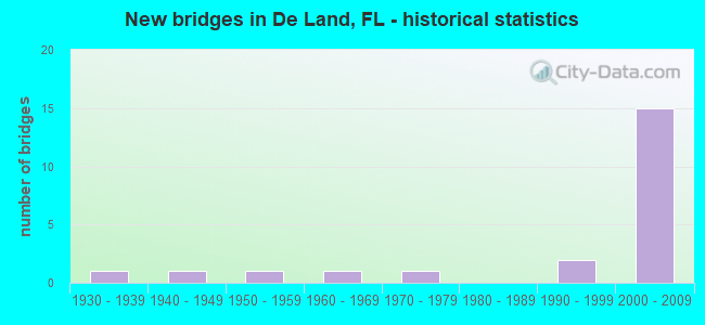
- New bridges - historical statistics
- 11930-1939
- 11940-1949
- 11950-1959
- 11960-1969
- 11970-1979
- 21990-1999
- 152000-2009


- Bridge Condition - Superstructure
- 9.1%Very good
- 81.8%Good
- 9.1%Satisfactory

- Bridge Condition - Substructure
- 20.0%Very good
- 60.0%Good
- 10.0%Satisfactory
- 10.0%Poor

- Bridge Condition - Channel
- 75.0%Good
- 12.5%Satisfactory
- 12.5%Fair

- Bridge Condition - Culverts
- 50.0%Good
- 50.0%Fair
Find on map >> Show street view
Structure Number: 790093, Location: 2.3 MI E of US-17 (Lat: 29.060703, Lng: -81.268472), Route carried "on" structure: US 92, Year Built: 1944, Year Reconstructed: 2010, Status: Open, Structure Length: 0.94m (3.08ft), Average Daily Traffic: 24,000 (year 2020), Truck Traffic: 3%, Average Future Daily Traffic: 41,640 (year 2042), Design Load: HL 93, Features Intersected: Little Haw Creek
Minimum Vertical Clearance: 30+ m (98+ ft), Kilometerpoint: 3.623, Lanes on structure: 4, Base Highway Network: Yes, Owner: State Highway Agency, Approaching Roadway Width: 17.2m (56.4ft), Skew: 10 degrees, Material/Design: Concrete, Design/Construction: Culvert, Number Of Spans In Main Unit: 3, Length of Maximum Span: 3.0m (9.8ft)
Condition: Channel: Fair, Culverts: Fair, Operating Rating: 42.5 metric tons, Method Used To Determine Operating Rating: Load and Resistance Factor (LRFR), Inventory Rating: 32.7 metric tons, Method Used To Determine Inventory Rating: Load and Resistance Factor (LRFR), Structural Evaluation: Somewhat better than minimum adequacy, Waterway Adequacy: Equal to present desirable criteria, Approach Roadway Alignment: Equal to present desirable criteria, Designated Inspection Frequency: Every 24 months, Inspection Date: April 2021
Find on map >> Show street view
Structure Number: 790094, Location: 7.3 Mi N of US-17 (Lat: 29.166775, Lng: -81.298972), Route carried "on" structure: State highway 11, Year Built: 1959, Status: Open, Structure Length: 0.64m (2.10ft), Average Daily Traffic: 3,900 (year 2020), Truck Traffic: 12%, Average Future Daily Traffic: 6,766 (year 2042), Design Load: H 15, Features Intersected: Lake Dias Creek
Minimum Vertical Clearance: 30+ m (98+ ft), Kilometerpoint: 11.637, Lanes on structure: 2, Owner: State Highway Agency, Approaching Roadway Width: 11.0m (36.1ft), Material/Design: Concrete, Design/Construction: Culvert, Number Of Spans In Main Unit: 2, Length of Maximum Span: 3.0m (9.8ft)
Condition: Channel: Good, Culverts: Good, Operating Rating: 54.4 metric tons, Method Used To Determine Operating Rating: Load Factor (LF), Inventory Rating: 32.7 metric tons, Method Used To Determine Inventory Rating: Load Factor (LF), Structural Evaluation: Better than present minimum criteria, Waterway Adequacy: Equal to present desirable criteria, Approach Roadway Alignment: Equal to present desirable criteria, Designated Inspection Frequency: Every 24 months, Underwater Inspection Frequency: Every 24 months, Inspection Date: March 2020, Underwater Inspection Date: March 2020
Find on map >> Show street view
Structure Number: 790176, Location: SR-44 over CSX-RR (Lat: 29.024306, Lng: -81.354914), Route carried "on" structure: State highway 44, Year Built: 2001, Status: Open, Structure Length: 2.31m (7.58ft), Average Daily Traffic: 11,900 (year 2020), Truck Traffic: 10%, Average Future Daily Traffic: 20,646 (year 2042), Design Load: HS 20, Features Intersected: CSX-RR
Minimum Vertical Clearance: 30+ m (98+ ft), Kilometerpoint: 1.217, Lanes on structure: 2, Owner: State Highway Agency, Approaching Roadway Width: 13.2m (43.3ft), Material/Design: Prestressed concrete, Design/Construction: Stringer/Multi-beam, Number Of Spans In Main Unit: 1, Length of Maximum Span: 22.5m (73.8ft), Curb-To-Curb Width: 13.2m (43.3ft), Out-to-Out Width: 14.1m (46.3ft)
Condition: Deck: Good, Superstructure: Very good, Substructure: Good, Operating Rating: 62.7 metric tons, Method Used To Determine Operating Rating: Load Factor (LF), Inventory Rating: 39.0 metric tons, Method Used To Determine Inventory Rating: Load Factor (LF), Structural Evaluation: Better than present minimum criteria, Deck Geometry: Somewhat better than minimum adequacy, Underclear: Superior to present desirable criteria, Approach Roadway Alignment: Equal to present desirable criteria, Designated Inspection Frequency: Every 24 months, Inspection Date: July 2021, Deck Structure Type: Concrete Cast-file-Place, Wearing Surface/Protective System: Wearing Surface: Monolithic Concrete
Find on map >> Show street view
Structure Number: 790189, Location: SR-44 EB - I-4 (Lat: 29.017419, Lng: -81.231947), Route carried "on" structure: State highway 44, Year Built: 2006, Status: Open, Structure Length: 11.16m (36.61ft), Average Daily Traffic: 9,550 (year 2020), Truck Traffic: 8%, Average Future Daily Traffic: 16,569 (year 2042), Design Load: HS 20, Features Intersected: I-4 EB
Minimum Vertical Clearance: 30+ m (98+ ft), Kilometerpoint: 0.383, Lanes on structure: 2, Lanes under structure: 8, Owner: State Highway Agency, Approaching Roadway Width: 12.2m (40.0ft), Material/Design: Prestressed concrete continuous, Design/Construction: Stringer/Multi-beam, Number Of Spans In Main Unit: 2, Length of Maximum Span: 55.0m (180.4ft), Curb or Sidewalk Widths: Left: 0.0m, Right: 1.5m (4.9ft), Curb-To-Curb Width: 15.5m (50.9ft), Out-to-Out Width: 18.3m (60.0ft)
Condition: Deck: Good, Superstructure: Good, Substructure: Good, Operating Rating: 73.1 metric tons, Method Used To Determine Operating Rating: Load Factor (LF), Inventory Rating: 47.8 metric tons, Method Used To Determine Inventory Rating: Load Factor (LF), Structural Evaluation: Better than present minimum criteria, Deck Geometry: Superior to present desirable criteria, Underclear: Better than present minimum criteria, Approach Roadway Alignment: Equal to present desirable criteria, Designated Inspection Frequency: Every 24 months, Inspection Date: April 2021, Deck Structure Type: Concrete Cast-file-Place, Wearing Surface/Protective System: Wearing Surface: Monolithic Concrete
Find on map >> Show street view
Structure Number: 7902, Location: SR-44 WB over I-4 (Lat: 29.017717, Lng: -81.231700), Route carried "on" structure: State highway 44, Year Built: 2008, Status: Open, Structure Length: 11.16m (36.61ft), Average Daily Traffic: 9,550 (year 2020), Truck Traffic: 8%, Average Future Daily Traffic: 16,569 (year 2042), Design Load: HS 20, Features Intersected: I-4
Minimum Vertical Clearance: 30.45m (99.90ft), Kilometerpoint: 0.385, Lanes on structure: 2, Lanes under structure: 8, Owner: State Highway Agency, Approaching Roadway Width: 12.2m (40.0ft), Skew: 3 degrees, Material/Design: Prestressed concrete continuous, Design/Construction: Stringer/Multi-beam, Number Of Spans In Main Unit: 2, Length of Maximum Span: 55.0m (180.4ft), Curb or Sidewalk Widths: Left: 1.5m (4.9ft), Right: 0.0m, Curb-To-Curb Width: 15.5m (50.9ft), Out-to-Out Width: 18.3m (60.0ft)
Condition: Deck: Good, Superstructure: Good, Substructure: Good, Operating Rating: 74.7 metric tons, Method Used To Determine Operating Rating: Load Factor (LF), Inventory Rating: 48.8 metric tons, Method Used To Determine Inventory Rating: Load Factor (LF), Structural Evaluation: Better than present minimum criteria, Deck Geometry: Superior to present desirable criteria, Underclear: Better than present minimum criteria, Approach Roadway Alignment: Equal to present desirable criteria, Designated Inspection Frequency: Every 24 months, Inspection Date: April 2021, Deck Structure Type: Concrete Cast-file-Place, Wearing Surface/Protective System: Wearing Surface: Monolithic Concrete
Find on map >> Show street view
Structure Number: 79021, Location: Cassadaga Road over I-4 (Lat: 28.966272, Lng: -81.254183), Route carried "on" structure: Alternate County highway , Year Built: 2007, Status: Open, Structure Length: 7.25m (23.79ft), Average Daily Traffic: 1,900 (year 2020), Truck Traffic: 3%, Average Future Daily Traffic: 3,296 (year 2042), Design Load: HS 20, Features Intersected: I-4, Facility Carried by Structure: Cassadaga Road
Minimum Vertical Clearance: 30+ m (98+ ft), Kilometerpoint: 6.244, Lanes on structure: 2, Lanes under structure: 6, Owner: State Highway Agency, Approaching Roadway Width: 13.4m (44.0ft), Skew: 1 degrees, Material/Design: Prestressed concrete, Design/Construction: Stringer/Multi-beam, Number Of Spans In Main Unit: 2, Length of Maximum Span: 36.0m (118.1ft), Curb-To-Curb Width: 13.4m (44.0ft), Out-to-Out Width: 14.4m (47.2ft)
Condition: Deck: Good, Superstructure: Good, Substructure: Very good, Inventory Rating: 54.2 metric tons, Method Used To Determine Inventory Rating: Load Factor (LF), Structural Evaluation: Better than present minimum criteria, Deck Geometry: Equal to present desirable criteria, Underclear: Superior to present desirable criteria, Approach Roadway Alignment: Equal to present desirable criteria, Designated Inspection Frequency: Every 24 months, Inspection Date: June 2021, Deck Structure Type: Concrete Cast-file-Place, Wearing Surface/Protective System: Wearing Surface: Monolithic Concrete
Find on map >> Show street view
Structure Number: 790212, Location: CR-4139 over I-4 (Lat: 29.004022, Lng: -81.242186), Route carried "on" structure: City street 4, Year Built: 2008, Status: Open, Structure Length: 12.19m (39.99ft), Average Daily Traffic: 1,900 (year 2020), Truck Traffic: 2%, Average Future Daily Traffic: 3,296 (year 2042), Design Load: HS 20, Features Intersected: I-4
Minimum Vertical Clearance: 30+ m (98+ ft), Kilometerpoint: 13.350, Lanes on structure: 2, Lanes under structure: 6, Owner: State Highway Agency, Approaching Roadway Width: 10.5m (34.4ft), Skew: 5 degrees, Material/Design: Steel continuous, Design/Construction: Stringer/Multi-beam, Number Of Spans In Main Unit: 2, Length of Maximum Span: 60.7m (199.1ft), Curb-To-Curb Width: 10.5m (34.4ft), Out-to-Out Width: 13.1m (43.0ft)
Condition: Deck: Good, Superstructure: Good, Substructure: Very good, Operating Rating: 58.3 metric tons, Method Used To Determine Operating Rating: Load Factor (LF), Inventory Rating: 35.0 metric tons, Method Used To Determine Inventory Rating: Load Factor (LF), Structural Evaluation: Better than present minimum criteria, Deck Geometry: Equal to present minimum criteria, Underclear: Superior to present desirable criteria, Approach Roadway Alignment: Equal to present desirable criteria, Designated Inspection Frequency: Every 24 months, Inspection Date: June 2020, Deck Structure Type: Concrete Cast-file-Place, Wearing Surface/Protective System: Wearing Surface: Monolithic Concrete
Find on map >> Show street view
Structure Number: 7908, Location: Lake George Conservation (Lat: 29.260928, Lng: -81.355314), Route carried "on" structure: ServiceOther road , Year Built: 1998, Status: Posted for load, Structure Length: 0.91m (2.99ft), Average Daily Traffic: 5 (year 2010), Truck Traffic: 1%, Average Future Daily Traffic: 10 (year 2033), Features Intersected: Little Haw Swamp, Facility Carried by Structure: Truck Trail #12
Minimum Vertical Clearance: 30+ m (98+ ft), Kilometerpoint: 0.000, Lanes on structure: 1, Owner: State Agenciy, Approaching Roadway Width: 3.3m (10.8ft), Material/Design: Prestressed concrete, Design/Construction: Stringer/Multi-beam, Number Of Spans In Main Unit: 1, Length of Maximum Span: 9.1m (29.9ft), Curb-To-Curb Width: 3.3m (10.8ft), Out-to-Out Width: 3.3m (10.8ft)
Condition: Deck: Good, Superstructure: Good, Channel: Good, Operating Rating: 3.5 metric tons, Method Used To Determine Operating Rating: Load Factor (LF), Inventory Rating: 2.6 metric tons, Method Used To Determine Inventory Rating: Load Factor (LF), Structural Evaluation: High priority of corrective action, Deck Geometry: High priority of replacement, Waterway Adequacy: Equal to present minimum criteria, Approach Roadway Alignment: Equal to present minimum criteria, Bridge Posting: Required (Relationship of Operating Rating to Maximum Legal Load: > 39.9% below), Designated Inspection Frequency: Every 24 months, Other Special Inspection Frequency: Every 24 months, Inspection Date: September 2020, Other Special Inspection Date: September 2021, Deck Structure Type: Wood or Timber, Wearing Surface/Protective System: Wearing Surface: Wood or Timber
Find on map >> Show street view
Structure Number: 794014, Location: 0.5 Mi. W. of Kepler Rd. (Lat: 29.035967, Lng: -81.267550), Route carried "on" structure: County highway , Year Built: 1962, Status: Open, Structure Length: 0.76m (2.49ft), Average Daily Traffic: 1,400 (year 2020), Truck Traffic: 5%, Average Future Daily Traffic: 2,429 (year 2042), Design Load: HS 20, Features Intersected: Blue Lake Equalizer, Facility Carried by Structure: E. Minnesota Ave.
Minimum Vertical Clearance: 30+ m (98+ ft), Kilometerpoint: 3.104, Lanes on structure: 2, Owner: County Highway Agency, Approaching Roadway Width: 6.4m (21.0ft), Skew: 1 degrees, Material/Design: Prestressed concrete, Design/Construction: Channel Beam, Number Of Spans In Main Unit: 1, Length of Maximum Span: 7.6m (24.9ft), Curb or Sidewalk Widths: Left: 0.4m (1.3ft), Right: 0.4m (1.3ft), Curb-To-Curb Width: 8.0m (26.2ft), Out-to-Out Width: 9.5m (31.2ft)
Condition: Deck: Good, Superstructure: Good, Substructure: Satisfactory, Channel: Good, Operating Rating: 42.1 metric tons, Method Used To Determine Operating Rating: Load Factor (LF), Inventory Rating: 25.1 metric tons, Method Used To Determine Inventory Rating: Load Factor (LF), Structural Evaluation: Equal to present minimum criteria, Deck Geometry: Meets minimum limits, Waterway Adequacy: Equal to present minimum criteria, Approach Roadway Alignment: Equal to present desirable criteria, Designated Inspection Frequency: Every 24 months, Inspection Date: April 2020, Deck Structure Type: Other, Wearing Surface/Protective System: Wearing Surface: Bituminous
Find on map >> Show street view
Structure Number: 794065, Location: 0.1 Mi. W. of Marsh Rd. (Lat: 29.065597, Lng: -81.272511), Route carried "on" structure: City street , Year Built: 1937, Status: Open, Structure Length: 0.99m (3.25ft), Average Daily Traffic: 40 (year 2021), Truck Traffic: 2%, Average Future Daily Traffic: 60 (year 2042), Design Load: HS 20, Features Intersected: Little Haw Creek, Facility Carried by Structure: Old Daytona Rd
Minimum Vertical Clearance: 30+ m (98+ ft), Kilometerpoint: 0.016, Lanes on structure: 2, Owner: City or Municipal Highway Agency, Approaching Roadway Width: 5.5m (18.0ft), Material/Design: Steel, Design/Construction: Stringer/Multi-beam, Number Of Spans In Main Unit: 1, Length of Maximum Span: 9.9m (32.5ft), Curb or Sidewalk Widths: Left: 0.2m (0.7ft), Right: 0.2m (0.7ft), Curb-To-Curb Width: 7.3m (24.0ft), Out-to-Out Width: 8.1m (26.6ft)
Condition: Deck: Good, Superstructure: Satisfactory, Substructure: Poor, Channel: Satisfactory, Operating Rating: 62.5 metric tons, Method Used To Determine Operating Rating: Load Factor (LF), Inventory Rating: 37.6 metric tons, Method Used To Determine Inventory Rating: Load Factor (LF), Structural Evaluation: Meets minimum limits, Deck Geometry: Equal to present minimum criteria, Waterway Adequacy: Better than present minimum criteria, Approach Roadway Alignment: Equal to present desirable criteria, Designated Inspection Frequency: Every 24 months, Other Special Inspection Frequency: Every 12 months, Inspection Date: April 2020, Other Special Inspection Date: April 2021, Deck Structure Type: Concrete Cast-file-Place, Wearing Surface/Protective System: Wearing Surface: Bituminous
Find on map >> Show street view
Structure Number: 794067, Location: 1.1 Mi. North of US-92 (Lat: 29.075642, Lng: -81.273264), Route carried "on" structure: County highway 4047, Year Built: 1975, Status: Open, Structure Length: 1.08m (3.54ft), Average Daily Traffic: 500 (year 2020), Truck Traffic: 5%, Average Future Daily Traffic: 868 (year 2042), Design Load: HS 20, Features Intersected: Little Haw Creek, Facility Carried by Structure: Marsh Road
Minimum Vertical Clearance: 30+ m (98+ ft), Kilometerpoint: 1.801, Lanes on structure: 2, Owner: County Highway Agency, Approaching Roadway Width: 6.1m (20.0ft), Material/Design: Prestressed concrete, Design/Construction: Slab, Number Of Spans In Main Unit: 1, Length of Maximum Span: 10.8m (35.4ft), Curb or Sidewalk Widths: Left: 0.3m (1.0ft), Right: 0.3m (1.0ft), Curb-To-Curb Width: 8.5m (27.9ft), Out-to-Out Width: 9.8m (32.2ft)
Condition: Deck: Good, Superstructure: Good, Substructure: Good, Channel: Good, Operating Rating: 69.4 metric tons, Method Used To Determine Operating Rating: Load Factor (LF), Inventory Rating: 41.6 metric tons, Method Used To Determine Inventory Rating: Load Factor (LF), Structural Evaluation: Better than present minimum criteria, Deck Geometry: Somewhat better than minimum adequacy, Waterway Adequacy: Equal to present desirable criteria, Approach Roadway Alignment: Equal to present desirable criteria, Designated Inspection Frequency: Every 24 months, Inspection Date: April 2020, Deck Structure Type: Concrete Precast Panels, Wearing Surface/Protective System: Wearing Surface: Bituminous
Find on map >> Show street view
Structure Number: 794121, Location: 0.4 Mi West of US 17-92 (Lat: 29.054728, Lng: -81.311314), Route carried "on" structure: County highway 92, Year Built: 1991, Status: Open, Structure Length: 10.67m (35.01ft), Average Daily Traffic: 14,500 (year 2021), Truck Traffic: 9%, Average Future Daily Traffic: 25,158 (year 2042), Design Load: HS 20, Features Intersected: Lake Gertie
Minimum Vertical Clearance: 30+ m (98+ ft), Kilometerpoint: 1.289, Lanes on structure: 2, Owner: County Highway Agency, Approaching Roadway Width: 8.9m (29.2ft), Material/Design: Prestressed concrete, Design/Construction: Stringer/Multi-beam, Number Of Spans In Main Unit: 5, Length of Maximum Span: 21.3m (69.9ft), Curb or Sidewalk Widths: Left: 2.0m (6.6ft), Right: 0.0m, Curb-To-Curb Width: 11.4m (37.4ft), Out-to-Out Width: 14.3m (46.9ft)
Condition: Deck: Good, Superstructure: Good, Substructure: Good, Channel: Good, Operating Rating: 46.7 metric tons, Method Used To Determine Operating Rating: Allowable Stress (AS), Inventory Rating: 40.8 metric tons, Method Used To Determine Inventory Rating: Allowable Stress (AS), Structural Evaluation: Better than present minimum criteria, Deck Geometry: Equal to present minimum criteria, Waterway Adequacy: Equal to present desirable criteria, Approach Roadway Alignment: Equal to present desirable criteria, Designated Inspection Frequency: Every 24 months, Inspection Date: August 2021, Deck Structure Type: Concrete Cast-file-Place
Find on map >> Show street view
Structure Number: 794186, Location: 0.4 Mile West of US 17-92 (Lat: 29.054539, Lng: -81.311325), Route carried "on" structure: County highway 92, Year Built: 2003, Status: Open, Structure Length: 10.67m (35.01ft), Average Daily Traffic: 14,500 (year 2021), Truck Traffic: 9%, Average Future Daily Traffic: 25,158 (year 2042), Design Load: HS 20+Mod, Features Intersected: Lake Gertie
Minimum Vertical Clearance: 30+ m (98+ ft), Kilometerpoint: 1.292, Lanes on structure: 2, Owner: County Highway Agency, Approaching Roadway Width: 10.1m (33.1ft), Material/Design: Prestressed concrete, Design/Construction: Stringer/Multi-beam, Number Of Spans In Main Unit: 5, Length of Maximum Span: 21.3m (69.9ft), Curb or Sidewalk Widths: Left: 0.0m, Right: 2.0m (6.6ft), Curb-To-Curb Width: 11.3m (37.1ft), Out-to-Out Width: 13.9m (45.6ft)
Condition: Deck: Good, Superstructure: Good, Substructure: Good, Channel: Good, Operating Rating: 74.1 metric tons, Method Used To Determine Operating Rating: Load Factor (LF), Inventory Rating: 44.5 metric tons, Method Used To Determine Inventory Rating: Load Factor (LF), Structural Evaluation: Better than present minimum criteria, Deck Geometry: Equal to present minimum criteria, Waterway Adequacy: Equal to present desirable criteria, Approach Roadway Alignment: Equal to present desirable criteria, Designated Inspection Frequency: Every 24 months, Inspection Date: August 2021, Deck Structure Type: Concrete Cast-file-Place
Find on map >> Show street view
Structure Number: 790189, Location: SR-44 EB - I-4 (Lat: 29.017419, Lng: -81.231947), Route carried "under" structure: Ramp Interstate 400, Year Built: 2006, Structure Length: 0. m, Average Daily Traffic: 1,100 (year 2020), Truck Traffic: 7%, Features Intersected: I-4 EB, Facility Carried by Structure: SR-44 EB
Minimum Vertical Clearance: 6.04m (19.82ft), Kilometerpoint: 0.483, Lanes on structure: 2, Lanes under structure: 1, Material/Design: Prestressed concrete continuous, Design/Construction: Stringer/Multi-beam, Length of Maximum Span: 55.0m (180.4ft)
Find on map >> Show street view
Structure Number: 790189, Location: SR-44 EB - I-4 (Lat: 29.017419, Lng: -81.231947), Route carried "under" structure: Interstate 400, Year Built: 2006, Structure Length: 0. m, Average Daily Traffic: 78,000 (year 2020), Truck Traffic: 10%, Features Intersected: I-4 EB, Facility Carried by Structure: SR-44 EB
Minimum Vertical Clearance: 5.94m (19.49ft), Kilometerpoint: 22.730, Lanes on structure: 2, Lanes under structure: 6, Material/Design: Prestressed concrete continuous, Design/Construction: Stringer/Multi-beam, Length of Maximum Span: 55.0m (180.4ft)
Find on map >> Show street view
Structure Number: 790189, Location: SR-44 EB - I-4 (Lat: 29.017419, Lng: -81.231947), Route carried "under" structure: Ramp Interstate 400, Year Built: 2006, Structure Length: 0. m, Average Daily Traffic: 3,500 (year 2020), Truck Traffic: 7%, Features Intersected: I-4 EB, Facility Carried by Structure: SR-44 EB
Minimum Vertical Clearance: 5.64m (18.50ft), Kilometerpoint: 0.489, Lanes on structure: 2, Lanes under structure: 1, Material/Design: Prestressed concrete continuous, Design/Construction: Stringer/Multi-beam, Length of Maximum Span: 55.0m (180.4ft)
Find on map >> Show street view
Structure Number: 7902, Location: SR-44 WB over I-4 (Lat: 29.017717, Lng: -81.231700), Route carried "under" structure: Ramp Other road , Year Built: 2008, Structure Length: 0. m, Average Daily Traffic: 1,100 (year 2020), Truck Traffic: 7%, Features Intersected: I-4, Facility Carried by Structure: SR-44 WB
Minimum Vertical Clearance: 6.16m (20.21ft), Kilometerpoint: 0.388, Lanes on structure: 2, Lanes under structure: 1, Material/Design: Prestressed concrete continuous, Design/Construction: Stringer/Multi-beam, Length of Maximum Span: 55.0m (180.4ft)
Find on map >> Show street view
Structure Number: 7902, Location: SR-44 WB over I-4 (Lat: 29.017717, Lng: -81.231700), Route carried "under" structure: Interstate 400, Year Built: 2008, Structure Length: 0. m, Average Daily Traffic: 65,500 (year 2017), Truck Traffic: 15%, Features Intersected: I-4, Facility Carried by Structure: SR-44 WB
Minimum Vertical Clearance: 6.28m (20.60ft), Kilometerpoint: 0.398, Lanes on structure: 2, Lanes under structure: 6, Material/Design: Prestressed concrete continuous, Design/Construction: Stringer/Multi-beam, Length of Maximum Span: 55.0m (180.4ft)
Find on map >> Show street view
Structure Number: 7902, Location: SR-44 WB over I-4 (Lat: 29.017717, Lng: -81.231700), Route carried "under" structure: Ramp Other road , Year Built: 2008, Structure Length: 0. m, Average Daily Traffic: 3,500 (year 2020), Truck Traffic: 7%, Features Intersected: I-4, Facility Carried by Structure: SR-44 WB
Minimum Vertical Clearance: 5.30m (17.39ft), Kilometerpoint: 0.463, Lanes on structure: 2, Lanes under structure: 1, Material/Design: Prestressed concrete continuous, Design/Construction: Stringer/Multi-beam, Length of Maximum Span: 55.0m (180.4ft)
Find on map >> Show street view
Structure Number: 79021, Location: Cassadaga Road over I-4 (Lat: 28.966272, Lng: -81.254183), Route carried "under" structure: Interstate 4, Year Built: 2007, Structure Length: 0. m, Average Daily Traffic: 77,000 (year 2020), Truck Traffic: 14%, Features Intersected: I-4, Facility Carried by Structure: Cassadaga Road
Minimum Vertical Clearance: 5.58m (18.31ft), Kilometerpoint: 16.581, Lanes on structure: 2, Lanes under structure: 6, Material/Design: Prestressed concrete, Design/Construction: Stringer/Multi-beam, Length of Maximum Span: 36.0m (118.1ft)
Find on map >> Show street view
Structure Number: 790212, Location: CR-4139 over I-4 (Lat: 29.004022, Lng: -81.242186), Route carried "under" structure: Interstate 400, Year Built: 2008, Structure Length: 0. m, Average Daily Traffic: 78,000 (year 2020), Truck Traffic: 10%, Features Intersected: I-4, Facility Carried by Structure: CR-4139
Minimum Vertical Clearance: 5.39m (17.68ft), Kilometerpoint: 20.912, Lanes on structure: 2, Lanes under structure: 6, Material/Design: Steel continuous, Design/Construction: Stringer/Multi-beam, Length of Maximum Span: 60.7m (199.1ft)
Find on map >> Show street view
Structure Number: 799002, Location: Kepler Road Complex (Lat: 29.057000, Lng: -81.262742), Route carried "under" structure: Alternate County highway 4104, Year Built: 2000, Structure Length: 0. m, Average Daily Traffic: 15,600 (year 2020), Truck Traffic: 9%, Features Intersected: Kepler Road, Facility Carried by Structure: Ped Overpass
Minimum Vertical Clearance: 5.24m (17.19ft), Kilometerpoint: 20.324, Lanes under structure: 3, Material/Design: Steel, Design/Construction: Truss - Thru, Length of Maximum Span: 30.2m (99.1ft)