Bridge Statistics for De Bary, Florida (FL)
Condition, Traffic, Stress, Structural Evaluation, Project Costs
- National Bridge Inventory (NBI) Statistics
- 16Number of bridges
- 991ft / 302mTotal length
- 313,688Total average daily traffic
- 25,760Total average daily truck traffic
- National Bridge Inventory (NBI) Registered Bridges for De Bary
- No street view available for this location
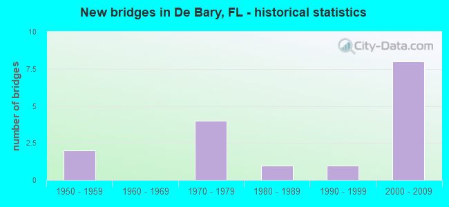
- New bridges - historical statistics
- 21950-1959
- 41970-1979
- 11980-1989
- 11990-1999
- 82000-2009


- Bridge Condition - Deck
- 71.4%Good
- 28.6%Satisfactory

- Bridge Condition - Superstructure
- 14.3%Very good
- 85.7%Good

- Bridge Condition - Substructure
- 14.3%Very good
- 85.7%Good

- Bridge Condition - Channel
- 20.0%Very good
- 70.0%Good
- 10.0%Fair

- Bridge Condition - Culverts
- 75.0%Good
- 25.0%Satisfactory
Find on map >> Show street view
Structure Number: 77007, Location: US-17-92 -St. Johns River (Lat: 28.837464, Lng: -81.324347), Route carried "on" structure: US 1792, Year Built: 1994, Status: Open, Structure Length: 50.20m (164.70ft), Average Daily Traffic: 32,000 (year 2020), Truck Traffic: 4%, Average Future Daily Traffic: 55,520 (year 2042), Design Load: HS 20, Features Intersected: St. Johns River, Facility Carried by Structure: US-17-92
Minimum Vertical Clearance: 30+ m (98+ ft), Kilometerpoint: 0.330, Lanes on structure: 4, Owner: State Highway Agency, Approaching Roadway Width: 20.4m (66.9ft), Skew: 30 degrees, Navigation Control: Yes ( Vertical Clearance: 13.1m (43.0ft), Horizontal Clearance: 33.5m (109.9ft)), Material/Design: Prestressed concrete continuous, Design/Construction: Stringer/Multi-beam, Number Of Spans In Main Unit: 13, Length of Maximum Span: 61.0m (200.1ft), Curb or Sidewalk Widths: Left: 0.0m, Right: 3.0m (9.8ft), Curb-To-Curb Width: 20.4m (66.9ft), Out-to-Out Width: 26.1m (85.6ft)
Condition: Deck: Good, Superstructure: Good, Substructure: Good, Channel: Good, Operating Rating: 48.0 metric tons, Method Used To Determine Operating Rating: Load and Resistance Factor (LRFR), Inventory Rating: 34.9 metric tons, Method Used To Determine Inventory Rating: Load and Resistance Factor (LRFR), Structural Evaluation: Better than present minimum criteria, Deck Geometry: Superior to present desirable criteria, Waterway Adequacy: Superior to present desirable criteria, Approach Roadway Alignment: Equal to present desirable criteria, Designated Inspection Frequency: Every 24 months, Underwater Inspection Frequency: Every 24 months, Inspection Date: July 2020, Underwater Inspection Date: August 2020, Deck Structure Type: Concrete Cast-file-Place, Wearing Surface/Protective System: Wearing Surface: Monolithic Concrete
Find on map >> Show street view
Structure Number: 770089, Location: I-4 EB Ramp to US-17-92 (Lat: 28.832497, Lng: -81.321389), Route carried "on" structure: Ramp Interstate 4, Year Built: 2007, Status: Open, Structure Length: 78.65m (258.04ft), Average Daily Traffic: 8,600 (year 2020), Truck Traffic: 8%, Average Future Daily Traffic: 14,921 (year 2042), Design Load: HS 20, Features Intersected: US-17-92 & Orange Blvd
Minimum Vertical Clearance: 30+ m (98+ ft), Kilometerpoint: 0.377, Lanes on structure: 2, Lanes under structure: 8, Owner: State Highway Agency, Approaching Roadway Width: 11.3m (37.1ft), Material/Design: Prestressed concrete, Design/Construction: Stringer/Multi-beam, Number Of Spans In Main Unit: 24, Length of Maximum Span: 42.7m (140.1ft), Curb-To-Curb Width: 12.2m (40.0ft), Out-to-Out Width: 12.2m (40.0ft)
Condition: Deck: Good, Superstructure: Very good, Substructure: Very good, Operating Rating: 68.9 metric tons, Method Used To Determine Operating Rating: Load Factor (LF), Inventory Rating: 41.4 metric tons, Method Used To Determine Inventory Rating: Load Factor (LF), Structural Evaluation: Equal to present desirable criteria, Deck Geometry: Superior to present desirable criteria, Underclear: Better than present minimum criteria, Approach Roadway Alignment: Equal to present desirable criteria, Designated Inspection Frequency: Every 24 months, Inspection Date: November 2021, Deck Structure Type: Concrete Cast-file-Place, Wearing Surface/Protective System: Wearing Surface: Monolithic Concrete
Find on map >> Show street view
Structure Number: 790099, Location: I-4 EB - Padgett Creek (Lat: 28.868778, Lng: -81.285950), Route carried "on" structure: Interstate 4, Year Built: 1959, Year Reconstructed: 2005, Status: Open, Structure Length: 4.69m (15.39ft), Average Daily Traffic: 52,000 (year 2020), Truck Traffic: 10%, Average Future Daily Traffic: 90,220 (year 2042), Design Load: HS 20+Mod, Features Intersected: Padgett Creek
Minimum Vertical Clearance: 30+ m (98+ ft), Kilometerpoint: 5.298, Lanes on structure: 3, Base Highway Network: Yes, Owner: State Highway Agency, Approaching Roadway Width: 18.3m (60.0ft), Material/Design: Prestressed concrete, Design/Construction: Stringer/Multi-beam, Number Of Spans In Main Unit: 3, Length of Maximum Span: 17.4m (57.1ft), Curb-To-Curb Width: 17.1m (56.1ft), Out-to-Out Width: 18.0m (59.1ft)
Condition: Deck: Satisfactory, Superstructure: Good, Substructure: Good, Channel: Very good, Operating Rating: 60.9 metric tons, Method Used To Determine Operating Rating: Load Factor (LF), Inventory Rating: 41.3 metric tons, Method Used To Determine Inventory Rating: Load Factor (LF), Structural Evaluation: Better than present minimum criteria, Deck Geometry: Equal to present minimum criteria, Waterway Adequacy: Equal to present desirable criteria, Approach Roadway Alignment: Equal to present desirable criteria, Designated Inspection Frequency: Every 24 months, Inspection Date: November 2020, Deck Structure Type: Concrete Cast-file-Place, Wearing Surface/Protective System: Wearing Surface: Monolithic Concrete
Find on map >> Show street view
Structure Number: 790196, Location: I-4WB-US-17-92 St Johns R (Lat: 28.835578, Lng: -81.319619), Route carried "on" structure: Interstate 4, Year Built: 2002, Status: Open, Structure Length: 78.27m (256.79ft), Average Daily Traffic: 52,000 (year 2020), Truck Traffic: 10%, Average Future Daily Traffic: 90,220 (year 2042), Design Load: HS 20, Features Intersected: US-17-92 -St Johns River
Minimum Vertical Clearance: 30+ m (98+ ft), Kilometerpoint: 0.000, Lanes on structure: 3, Lanes under structure: 4, Base Highway Network: Yes, Owner: State Highway Agency, Approaching Roadway Width: 17.7m (58.1ft), Navigation Control: Yes ( Vertical Clearance: 13.1m (43.0ft), Horizontal Clearance: 33.5m (109.9ft)), Material/Design: Prestressed concrete, Design/Construction: Stringer/Multi-beam, Number Of Spans In Main Unit: 20, Length of Maximum Span: 43.6m (143.0ft), Curb-To-Curb Width: 17.7m (58.1ft), Out-to-Out Width: 18.6m (61.0ft)
Condition: Deck: Good, Superstructure: Good, Substructure: Good, Channel: Good, Operating Rating: 50.6 metric tons, Method Used To Determine Operating Rating: Load Factor (LF), Inventory Rating: 30.3 metric tons, Method Used To Determine Inventory Rating: Load Factor (LF), Structural Evaluation: Better than present minimum criteria, Deck Geometry: Better than present minimum criteria, Underclear: Superior to present desirable criteria, Waterway Adequacy: Superior to present desirable criteria, Approach Roadway Alignment: Equal to present desirable criteria, Designated Inspection Frequency: Every 24 months, Underwater Inspection Frequency: Every 24 months, Inspection Date: July 2020, Underwater Inspection Date: July 2020, Deck Structure Type: Concrete Cast-file-Place, Wearing Surface/Protective System: Wearing Surface: Monolithic Concrete
Find on map >> Show street view
Structure Number: 790197, Location: I-4EB-US-17-92 St Johns R (Lat: 28.835211, Lng: -81.319106), Route carried "on" structure: Interstate 4, Year Built: 2003, Status: Open, Structure Length: 78.30m (256.89ft), Average Daily Traffic: 52,000 (year 2020), Truck Traffic: 10%, Average Future Daily Traffic: 90,220 (year 2042), Design Load: HS 20, Features Intersected: US-17-92-St Johns River
Minimum Vertical Clearance: 30+ m (98+ ft), Kilometerpoint: 0.000, Lanes on structure: 3, Lanes under structure: 4, Base Highway Network: Yes, Owner: State Highway Agency, Approaching Roadway Width: 17.7m (58.1ft), Navigation Control: Yes ( Vertical Clearance: 13.1m (43.0ft), Horizontal Clearance: 33.5m (109.9ft)), Material/Design: Prestressed concrete, Design/Construction: Stringer/Multi-beam, Number Of Spans In Main Unit: 20, Length of Maximum Span: 43.4m (142.4ft), Curb-To-Curb Width: 17.7m (58.1ft), Out-to-Out Width: 18.6m (61.0ft)
Condition: Deck: Good, Superstructure: Good, Substructure: Good, Channel: Good, Operating Rating: 50.6 metric tons, Method Used To Determine Operating Rating: Load Factor (LF), Inventory Rating: 30.3 metric tons, Method Used To Determine Inventory Rating: Load Factor (LF), Structural Evaluation: Better than present minimum criteria, Deck Geometry: Better than present minimum criteria, Underclear: Superior to present desirable criteria, Waterway Adequacy: Superior to present desirable criteria, Approach Roadway Alignment: Equal to present desirable criteria, Designated Inspection Frequency: Every 24 months, Underwater Inspection Frequency: Every 24 months, Inspection Date: July 2020, Underwater Inspection Date: July 2020, Deck Structure Type: Concrete Cast-file-Place, Wearing Surface/Protective System: Wearing Surface: Monolithic Concrete
Find on map >> Show street view
Structure Number: 790941, Location: I-4 WB - Padgett Creek (Lat: 28.868900, Lng: -81.286183), Route carried "on" structure: Interstate 4, Year Built: 1959, Year Reconstructed: 2005, Status: Open, Structure Length: 4.69m (15.39ft), Average Daily Traffic: 52,000 (year 2020), Truck Traffic: 10%, Average Future Daily Traffic: 90,220 (year 2042), Design Load: HS 20+Mod, Features Intersected: Padgett Creek
Minimum Vertical Clearance: 30+ m (98+ ft), Kilometerpoint: 5.298, Lanes on structure: 3, Base Highway Network: Yes, Owner: State Highway Agency, Approaching Roadway Width: 21.3m (69.9ft), Material/Design: Prestressed concrete, Design/Construction: Stringer/Multi-beam, Number Of Spans In Main Unit: 3, Length of Maximum Span: 17.4m (57.1ft), Curb-To-Curb Width: 19.7m (64.6ft), Out-to-Out Width: 20.4m (66.9ft)
Condition: Deck: Satisfactory, Superstructure: Good, Substructure: Good, Channel: Very good, Operating Rating: 60.9 metric tons, Method Used To Determine Operating Rating: Load Factor (LF), Inventory Rating: 41.3 metric tons, Method Used To Determine Inventory Rating: Load Factor (LF), Structural Evaluation: Better than present minimum criteria, Deck Geometry: Superior to present desirable criteria, Waterway Adequacy: Equal to present desirable criteria, Approach Roadway Alignment: Equal to present desirable criteria, Designated Inspection Frequency: Every 24 months, Inspection Date: November 2020, Deck Structure Type: Concrete Cast-file-Place, Wearing Surface/Protective System: Wearing Surface: Monolithic Concrete
Find on map >> Show street view
Structure Number: 794076, Location: 0.2 mile west of US-17 (Lat: 28.845317, Lng: -81.325806), Route carried "on" structure: County highway , Year Built: 1970, Status: Open, Structure Length: 1.58m (5.18ft), Average Daily Traffic: 769 (year 2020), Truck Traffic: 5%, Average Future Daily Traffic: 930 (year 2042), Design Load: HS 20, Features Intersected: FPL Cooling Disch. Canal, Facility Carried by Structure: Barwick Road
Minimum Vertical Clearance: 30+ m (98+ ft), Kilometerpoint: 0.016, Lanes on structure: 2, Owner: City or Municipal Highway Agency, Approaching Roadway Width: 6.2m (20.3ft), Skew: 2 degrees, Material/Design: Concrete, Design/Construction: Culvert, Number Of Spans In Main Unit: 4, Length of Maximum Span: 3.7m (12.1ft)
Condition: Channel: Good, Culverts: Good, Operating Rating: 57.0 metric tons, Method Used To Determine Operating Rating: Load Factor (LF), Inventory Rating: 34.2 metric tons, Method Used To Determine Inventory Rating: Load Factor (LF), Structural Evaluation: Better than present minimum criteria, Waterway Adequacy: Equal to present minimum criteria, Approach Roadway Alignment: Equal to present desirable criteria, Designated Inspection Frequency: Every 24 months, Underwater Inspection Frequency: Every 24 months, Inspection Date: April 2020, Underwater Inspection Date: April 2020
Find on map >> Show street view
Structure Number: 794077, Location: 0.2 mile west of US-17 (Lat: 28.845314, Lng: -81.325397), Route carried "on" structure: County highway , Year Built: 1970, Status: Open, Structure Length: 1.58m (5.18ft), Average Daily Traffic: 769 (year 2020), Truck Traffic: 5%, Average Future Daily Traffic: 931 (year 2042), Design Load: HS 20, Features Intersected: FPL Cooling Intake Canal, Facility Carried by Structure: Barwick Rd.
Minimum Vertical Clearance: 30+ m (98+ ft), Kilometerpoint: 0.016, Lanes on structure: 2, Owner: City or Municipal Highway Agency, Approaching Roadway Width: 6.2m (20.3ft), Skew: 2 degrees, Material/Design: Concrete, Design/Construction: Culvert, Number Of Spans In Main Unit: 4, Length of Maximum Span: 3.7m (12.1ft)
Condition: Channel: Good, Culverts: Satisfactory, Operating Rating: 57.0 metric tons, Method Used To Determine Operating Rating: Load Factor (LF), Inventory Rating: 34.2 metric tons, Method Used To Determine Inventory Rating: Load Factor (LF), Structural Evaluation: Equal to present minimum criteria, Waterway Adequacy: Equal to present minimum criteria, Approach Roadway Alignment: Equal to present desirable criteria, Designated Inspection Frequency: Every 24 months, Underwater Inspection Frequency: Every 24 months, Inspection Date: April 2020, Underwater Inspection Date: April 2020
Find on map >> Show street view
Structure Number: 794078, Location: 0.2 mile west of US-17 (Lat: 28.856278, Lng: -81.325433), Route carried "on" structure: County highway , Year Built: 1970, Status: Open, Structure Length: 1.43m (4.69ft), Average Daily Traffic: 1,150 (year 2020), Truck Traffic: 7%, Average Future Daily Traffic: 1,996 (year 2042), Design Load: HS 20, Features Intersected: FPL Cooling Disch. Canal, Facility Carried by Structure: Fort Florida Road
Minimum Vertical Clearance: 30+ m (98+ ft), Kilometerpoint: 0.346, Lanes on structure: 2, Owner: City or Municipal Highway Agency, Approaching Roadway Width: 6.4m (21.0ft), Material/Design: Concrete, Design/Construction: Culvert, Number Of Spans In Main Unit: 4, Length of Maximum Span: 3.4m (11.2ft)
Condition: Channel: Good, Culverts: Good, Inventory Rating: 71.0 metric tons, Method Used To Determine Inventory Rating: Allowable Stress (AS), Structural Evaluation: Better than present minimum criteria, Waterway Adequacy: Equal to present minimum criteria, Approach Roadway Alignment: Equal to present desirable criteria, Designated Inspection Frequency: Every 24 months, Underwater Inspection Frequency: Every 24 months, Inspection Date: April 2020, Underwater Inspection Date: April 2020
Find on map >> Show street view
Structure Number: 794079, Location: 0.2 mile west of US-17 (Lat: 28.856281, Lng: -81.325031), Route carried "on" structure: County highway , Year Built: 1970, Status: Open, Structure Length: 1.43m (4.69ft), Average Daily Traffic: 1,150 (year 2020), Truck Traffic: 5%, Average Future Daily Traffic: 1,996 (year 2042), Design Load: HS 20, Features Intersected: FPL Cooling Intake Canal, Facility Carried by Structure: Fort Florida Road
Minimum Vertical Clearance: 30+ m (98+ ft), Kilometerpoint: 0.307, Lanes on structure: 2, Owner: City or Municipal Highway Agency, Approaching Roadway Width: 6.4m (21.0ft), Material/Design: Concrete, Design/Construction: Culvert, Number Of Spans In Main Unit: 4, Length of Maximum Span: 3.4m (11.2ft)
Condition: Channel: Good, Culverts: Good, Inventory Rating: 71.0 metric tons, Method Used To Determine Inventory Rating: Allowable Stress (AS), Structural Evaluation: Better than present minimum criteria, Waterway Adequacy: Equal to present minimum criteria, Approach Roadway Alignment: Equal to present desirable criteria, Designated Inspection Frequency: Every 24 months, Underwater Inspection Frequency: Every 24 months, Inspection Date: April 2020, Underwater Inspection Date: April 2020
Find on map >> Show street view
Structure Number: 794162, Location: 2.2 Mi. West of US-17/92 (Lat: 28.865100, Lng: -81.348075), Route carried "on" structure: County highway , Year Built: 1987, Status: Open, Structure Length: 1.22m (4.00ft), Average Daily Traffic: 1,150 (year 2020), Truck Traffic: 6%, Average Future Daily Traffic: 1,955 (year 2042), Design Load: HS 20, Features Intersected: Konomac Canal, Facility Carried by Structure: Fort Florida Road
Minimum Vertical Clearance: 30+ m (98+ ft), Kilometerpoint: 3.542, Lanes on structure: 2, Owner: City or Municipal Highway Agency, Approaching Roadway Width: 8.5m (27.9ft), Material/Design: Prestressed concrete, Design/Construction: Slab, Number Of Spans In Main Unit: 1, Length of Maximum Span: 12.2m (40.0ft), Curb-To-Curb Width: 8.5m (27.9ft), Out-to-Out Width: 9.4m (30.8ft)
Condition: Deck: Good, Superstructure: Good, Substructure: Good, Channel: Fair, Operating Rating: 45.2 metric tons, Method Used To Determine Operating Rating: Load Factor (LF), Inventory Rating: 27.1 metric tons, Method Used To Determine Inventory Rating: Load Factor (LF), Structural Evaluation: Equal to present minimum criteria, Deck Geometry: Somewhat better than minimum adequacy, Waterway Adequacy: Superior to present desirable criteria, Approach Roadway Alignment: Equal to present desirable criteria, Designated Inspection Frequency: Every 24 months, Inspection Date: April 2020, Deck Structure Type: Concrete Precast Panels, Wearing Surface/Protective System: Wearing Surface: Bituminous
Find on map >> Show street view
Structure Number: 770089, Location: I-4 EB Ramp to US-17-92 (Lat: 28.832497, Lng: -81.321389), Route carried "under" structure: Ramp County highway , Year Built: 2007, Structure Length: 0. m, Average Daily Traffic: 3,100 (year 2007), Truck Traffic: 10%, Features Intersected: US-17-92 & Orange Blvd, Facility Carried by Structure: I-4 EB Ramp
Minimum Vertical Clearance: 5.46m (17.91ft), Kilometerpoint: 0.000, Lanes on structure: 2, Lanes under structure: 1, Material/Design: Prestressed concrete, Design/Construction: Stringer/Multi-beam, Length of Maximum Span: 42.7m (140.1ft)
Find on map >> Show street view
Structure Number: 770089, Location: I-4 EB Ramp to US-17-92 (Lat: 28.832497, Lng: -81.321389), Route carried "under" structure: County highway , Year Built: 2007, Structure Length: 0. m, Average Daily Traffic: 15,000 (year 2007), Truck Traffic: 2%, Features Intersected: US-17-92 & Orange Blvd, Facility Carried by Structure: I-4 EB Ramp
Minimum Vertical Clearance: 6.25m (20.51ft), Kilometerpoint: 0.000, Lanes on structure: 2, Lanes under structure: 2, Material/Design: Prestressed concrete, Design/Construction: Stringer/Multi-beam, Length of Maximum Span: 42.7m (140.1ft)
Find on map >> Show street view
Structure Number: 770089, Location: I-4 EB Ramp to US-17-92 (Lat: 28.832497, Lng: -81.321389), Route carried "under" structure: State highway 1792, Year Built: 2007, Structure Length: 0. m, Average Daily Traffic: 14,000 (year 2020), Truck Traffic: 5%, Features Intersected: US-17-92 & Orange Blvd, Facility Carried by Structure: I-4 EB Ramp
Minimum Vertical Clearance: 5.15m (16.90ft), Kilometerpoint: 27.161, Lanes on structure: 2, Lanes under structure: 4, Material/Design: Prestressed concrete, Design/Construction: Stringer/Multi-beam, Length of Maximum Span: 42.7m (140.1ft)
Find on map >> Show street view
Structure Number: 790196, Location: I-4WB-US-17-92 St Johns R (Lat: 28.835578, Lng: -81.319619), Route carried "under" structure: US 600, Year Built: 2002, Structure Length: 0. m, Average Daily Traffic: 14,000 (year 2020), Truck Traffic: 5%, Features Intersected: US-17-92 -St Johns River, Facility Carried by Structure: I-4 WB
Minimum Vertical Clearance: 6.49m (21.29ft), Kilometerpoint: 27.225, Lanes on structure: 3, Lanes under structure: 4, Material/Design: Prestressed concrete, Design/Construction: Stringer/Multi-beam, Length of Maximum Span: 43.6m (143.0ft)
Find on map >> Show street view
Structure Number: 790197, Location: I-4EB-US-17-92 St Johns R (Lat: 28.835211, Lng: -81.319106), Route carried "under" structure: State highway 600, Year Built: 2003, Structure Length: 0. m, Average Daily Traffic: 14,000 (year 2020), Truck Traffic: 5%, Features Intersected: US-17-92-St Johns River, Facility Carried by Structure: I-4 EB
Minimum Vertical Clearance: 7.22m (23.69ft), Kilometerpoint: 27.161, Lanes on structure: 3, Lanes under structure: 4, Material/Design: Prestressed concrete, Design/Construction: Stringer/Multi-beam, Length of Maximum Span: 43.4m (142.4ft)