Bridge Statistics for Concord, Massachusetts (MA)
Condition, Traffic, Stress, Structural Evaluation, Project Costs
- National Bridge Inventory (NBI) Statistics
- 20Number of bridges
- 161ft / 49.5mTotal length
- $36,247,000Total costs
- 452,611Total average daily traffic
- 31,751Total average daily truck traffic
- 826,312Total future (year 21) average daily traffic
- National Bridge Inventory (NBI) Registered Bridges for Concord
- No street view available for this location
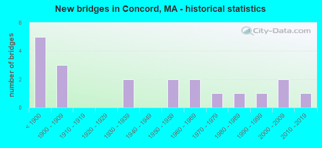
- New bridges - historical statistics
- 5Before 1900
- 31900-1909
- 21930-1939
- 21950-1959
- 21960-1969
- 11970-1979
- 11980-1989
- 11990-1999
- 22000-2009
- 12010-2019

- Reconstructed bridges - Historical Statistics
- 1Before 1900
- 01900-1909
- 01910-1919
- 21920-1929
- 01930-1939
- 01940-1949
- 01950-1959
- 01960-1969
- 11970-1979
- 01980-1989
- 01990-1999
- 32000-2009


- Bridge Condition - Deck
- 45.5%Good
- 36.4%Satisfactory
- 18.2%Fair

- Bridge Condition - Superstructure
- 5.0%Very good
- 10.0%Good
- 40.0%Satisfactory
- 35.0%Fair
- 10.0%Poor

- Bridge Condition - Substructure
- 25.0%Good
- 40.0%Satisfactory
- 35.0%Fair

- Bridge Condition - Channel
- 6.3%Very good
- 43.8%Good
- 43.8%Satisfactory
- 6.3%Fair
Find on map >> Show street view
Structure Number: C190012BEMUNNBI, Location: .2 MI NW OF RTE 62 (Lat: 42.458889, Lng: -71.397314), Route carried "on" structure: City street , Year Built: 1909, Status: Posted for load, Structure Length: 1.10m (3.61ft), Average Daily Traffic: 10,381 (year 2018), Truck Traffic: 7%, Average Future Daily Traffic: 16,109 (year 2032), Features Intersected: WATER FORT POND BROOK, Facility Carried by Structure: HWY COMMNWLTH AV
Minimum Vertical Clearance: 30+ m (98+ ft), Kilometerpoint: 0.515, Lanes on structure: 2, Owner: Town or Township Highway Agency, Approaching Roadway Width: 10.1m (33.1ft), Material/Design: Concrete, Design/Construction: Arch - Deck, Number Of Spans In Main Unit: 1, Length of Maximum Span: 11.0m (36.1ft), Curb or Sidewalk Widths: Left: 0.0m, Right: 1.6m (5.2ft), Curb-To-Curb Width: 9.2m (30.2ft), Out-to-Out Width: 12.6m (41.3ft)
Condition: Superstructure: Fair, Substructure: Fair, Channel: Fair, Operating Rating: 15.1 metric tons, Method Used To Determine Operating Rating: Load Factor (LF), Inventory Rating: 9.0 metric tons, Method Used To Determine Inventory Rating: Load Factor (LF), Structural Evaluation: High priority of corrective action, Deck Geometry: High priority of corrective action, Waterway Adequacy: Better than present minimum criteria, Approach Roadway Alignment: Somewhat better than minimum adequacy, Bridge Posting: Required (Relationship of Operating Rating to Maximum Legal Load: > 39.9% below), Length Of Structure Improvement: 1.20m (3.94ft), Designated Inspection Frequency: Every 24 months, Inspection Date: August 2021, Bridge Improvement Cost: $594,000, Roadway Improvement Cost: $60,000, Total Project Cost: $892,000 ( Estimate for 2022), Wearing Surface/Protective System: Wearing Surface: Bituminous
Find on map >> Show street view
Structure Number: C190022JWDOTNBI, Location: 1.2 KM NE RT 2 & RT 62 (Lat: 42.459536, Lng: -71.366353), Route carried "on" structure: State highway 2A, Year Built: 1874, Year Reconstructed: 1932, Status: Open, Structure Length: 2.56m (8.40ft), Average Daily Traffic: 13,100 (year 2018), Truck Traffic: 8%, Average Future Daily Traffic: 19,583 (year 2031), Features Intersected: WATER SUDBURY RIVER, Facility Carried by Structure: HWY ELM ST
Minimum Vertical Clearance: 30+ m (98+ ft), Kilometerpoint: 0.000, Lanes on structure: 2, Owner: State Highway Agency, Approaching Roadway Width: 8.5m (27.9ft), Material/Design: Masonry, Design/Construction: Arch - Deck, Number Of Spans In Main Unit: 3, Length of Maximum Span: 7.9m (25.9ft), Curb or Sidewalk Widths: Left: 1.3m (4.3ft), Right: 0.3m (1.0ft), Curb-To-Curb Width: 7.0m (23.0ft), Out-to-Out Width: 9.4m (30.8ft)
Condition: Superstructure: Poor, Substructure: Satisfactory, Channel: Good, Structural Evaluation: Meets minimum limits, Deck Geometry: High priority of replacement, Waterway Adequacy: Equal to present desirable criteria, Approach Roadway Alignment: Better than present minimum criteria, Length Of Structure Improvement: 2.60m (8.53ft), Designated Inspection Frequency: Every 12 months, Underwater Inspection Frequency: Every 24 months, Other Special Inspection Frequency: Every 12 months, Inspection Date: June 2020, Underwater Inspection Date: January 2021, Other Special Inspection Date: June 2021, Bridge Improvement Cost: $961,000, Roadway Improvement Cost: $97,000, Total Project Cost: $1,442,000 ( Estimate for 2022), Wearing Surface/Protective System: Wearing Surface: Bituminous
Find on map >> Show street view
Structure Number: C190032BFMUNNBI, Location: .8 KM SW OF RTE 2 (Lat: 42.441219, Lng: -71.368014), Route carried "on" structure: City street , Year Built: 1967, Year Reconstructed: 2008, Status: Open, Structure Length: 3.68m (12.07ft), Average Daily Traffic: 22,100 (year 2016), Truck Traffic: 2%, Average Future Daily Traffic: 57,960 (year 2031), Design Load: HS 25 or greater, Features Intersected: WATER SUDBURY RIVER, Facility Carried by Structure: HWY SUDBURY RD
Minimum Vertical Clearance: 30+ m (98+ ft), Kilometerpoint: 3.074, Lanes on structure: 2, Owner: Town or Township Highway Agency, Approaching Roadway Width: 9.2m (30.2ft), Material/Design: Steel, Design/Construction: Stringer/Multi-beam, Number Of Spans In Main Unit: 2, Length of Maximum Span: 17.5m (57.4ft), Curb or Sidewalk Widths: Left: 1.8m (5.9ft), Right: 1.8m (5.9ft), Curb-To-Curb Width: 9.2m (30.2ft), Out-to-Out Width: 13.7m (44.9ft)
Condition: Deck: Good, Superstructure: Satisfactory, Substructure: Good, Channel: Good, Operating Rating: 54.0 metric tons, Method Used To Determine Operating Rating: Load Factor (LF), Inventory Rating: 32.3 metric tons, Method Used To Determine Inventory Rating: Load Factor (LF), Structural Evaluation: Equal to present minimum criteria, Deck Geometry: High priority of corrective action, Waterway Adequacy: Superior to present desirable criteria, Approach Roadway Alignment: Equal to present desirable criteria, Length Of Structure Improvement: 3.70m (12.14ft), Designated Inspection Frequency: Every 24 months, Underwater Inspection Frequency: Every 36 months, Inspection Date: August 2020, Underwater Inspection Date: December 2018, Bridge Improvement Cost: $1,992,000, Roadway Improvement Cost: $200,000, Total Project Cost: $2,989,000 ( Estimate for 2022), Deck Structure Type: Concrete Cast-file-Place, Wearing Surface/Protective System: Wearing Surface: Bituminous, Membrane: Other, Deck Protection: Epoxy Coated Reinforcing
Find on map >> Show street view
Structure Number: C190042KJDOTNBI, Location: 1.0 KM NE RT 2 (Lat: 42.458033, Lng: -71.366178), Route carried "on" structure: State highway 62, Year Built: 1909, Status: Posted for load, Structure Length: 2.19m (7.19ft), Average Daily Traffic: 17,100 (year 2018), Truck Traffic: 5%, Average Future Daily Traffic: 27,977 (year 2031), Features Intersected: WATER SUDBURY RIVER
Minimum Vertical Clearance: 30+ m (98+ ft), Kilometerpoint: 76.323, Lanes on structure: 2, Base Highway Network: Yes, Owner: State Highway Agency, Approaching Roadway Width: 9.1m (29.9ft), Material/Design: Concrete, Design/Construction: Arch - Deck, Number Of Spans In Main Unit: 1, Length of Maximum Span: 21.9m (71.9ft), Curb or Sidewalk Widths: Left: 1.2m (3.9ft), Right: 0.0m, Curb-To-Curb Width: 8.2m (26.9ft), Out-to-Out Width: 9.9m (32.5ft)
Condition: Superstructure: Fair, Substructure: Fair, Channel: Satisfactory, Operating Rating: 66.1 metric tons, Method Used To Determine Operating Rating: Load Factor (LF), Inventory Rating: 41.7 metric tons, Method Used To Determine Inventory Rating: Load Factor (LF), Structural Evaluation: Somewhat better than minimum adequacy, Deck Geometry: High priority of replacement, Waterway Adequacy: Better than present minimum criteria, Approach Roadway Alignment: Meets minimum limits, Length Of Structure Improvement: 2.20m (7.22ft), Designated Inspection Frequency: Every 24 months, Underwater Inspection Frequency: Every 36 months, Inspection Date: November 2020, Underwater Inspection Date: Febuary 2022, Bridge Improvement Cost: $856,000, Roadway Improvement Cost: $86,000, Total Project Cost: $1,285,000 ( Estimate for 2022), Wearing Surface/Protective System: Wearing Surface: Bituminous
Find on map >> Show street view
Structure Number: C19005ALPDOTNBI, Location: 0.8 KM E OF SUDBURY RD (Lat: 42.420142, Lng: -71.364619), Route carried "on" structure: State highway 117, Year Built: 2009, Status: Open, Structure Length: 2.80m (9.19ft), Average Daily Traffic: 19,400 (year 2019), Truck Traffic: 12%, Average Future Daily Traffic: 19,583 (year 2032), Design Load: HS 20, Features Intersected: WATER SUDBURY RIVER
Minimum Vertical Clearance: 30+ m (98+ ft), Kilometerpoint: 38.325, Lanes on structure: 2, Owner: State Highway Agency, Approaching Roadway Width: 9.4m (30.8ft), Material/Design: Concrete, Design/Construction: Arch - Deck, Number Of Spans In Main Unit: 2, Length of Maximum Span: 18.9m (62.0ft), Curb or Sidewalk Widths: Left: 0.0m, Right: 1.5m (4.9ft), Curb-To-Curb Width: 8.0m (26.2ft), Out-to-Out Width: 10.8m (35.4ft)
Condition: Superstructure: Good, Substructure: Good, Channel: Good, Inventory Rating: 69.7 metric tons, Method Used To Determine Inventory Rating: Load Factor (LF), Structural Evaluation: Better than present minimum criteria, Deck Geometry: High priority of replacement, Waterway Adequacy: Equal to present desirable criteria, Approach Roadway Alignment: Equal to present minimum criteria, Length Of Structure Improvement: 2.90m (9.51ft), Designated Inspection Frequency: Every 24 months, Underwater Inspection Frequency: Every 36 months, Inspection Date: October 2021, Underwater Inspection Date: Febuary 2020, Bridge Improvement Cost: $1,477,000, Roadway Improvement Cost: $148,000, Total Project Cost: $2,216,000 ( Estimate for 2022), Wearing Surface/Protective System: Wearing Surface: Bituminous, Membrane: Other, Deck Protection: Epoxy Coated Reinforcing
Find on map >> Show street view
Structure Number: C190062CUMUNNBI, Location: .96 KM N OF RT 2 & 2A (Lat: 42.459847, Lng: -71.359292), Route carried "on" structure: City street , Year Built: 1883, Status: Open, Structure Length: 1.63m (5.35ft), Average Daily Traffic: 1,550 (year 2017), Average Future Daily Traffic: 6,317 (year 2032), Features Intersected: WATER SUDBURY RIVER, Facility Carried by Structure: HWY NASHAWTUC RD
Minimum Vertical Clearance: 30+ m (98+ ft), Kilometerpoint: 0.129, Lanes on structure: 2, Owner: Town or Township Highway Agency, Approaching Roadway Width: 7.6m (24.9ft), Material/Design: Masonry, Design/Construction: Arch - Deck, Number Of Spans In Main Unit: 1, Length of Maximum Span: 16.3m (53.5ft), Curb-To-Curb Width: 6.9m (22.6ft), Out-to-Out Width: 7.8m (25.6ft)
Condition: Superstructure: Satisfactory, Substructure: Satisfactory, Channel: Satisfactory, Operating Rating: 58.3 metric tons, Method Used To Determine Operating Rating: Load Factor (LF), Inventory Rating: 58.3 metric tons, Method Used To Determine Inventory Rating: Load Factor (LF), Structural Evaluation: Equal to present minimum criteria, Deck Geometry: High priority of corrective action, Waterway Adequacy: Better than present minimum criteria, Approach Roadway Alignment: Meets minimum limits, Length Of Structure Improvement: 1.70m (5.58ft), Designated Inspection Frequency: Every 24 months, Underwater Inspection Frequency: Every 36 months, Inspection Date: August 2021, Underwater Inspection Date: January 2022, Bridge Improvement Cost: $1,042,000, Roadway Improvement Cost: $105,000, Total Project Cost: $1,564,000 ( Estimate for 2022), Wearing Surface/Protective System: Wearing Surface: Bituminous
Find on map >> Show street view
Structure Number: C190072DVDOTNBI, Location: 0.64 KM E RT 2 ROTARY (Lat: 42.465731, Lng: -71.391239), Route carried "on" structure: State highway 2, Year Built: 1904, Year Reconstructed: 1934, Status: Open, Structure Length: 2.32m (7.61ft), Average Daily Traffic: 47,800 (year 2020), Truck Traffic: 10%, Average Future Daily Traffic: 120,027 (year 2031), Design Load: H 20, Features Intersected: WATER ASSABET RIVER
Minimum Vertical Clearance: 30+ m (98+ ft), Kilometerpoint: 194.635, Lanes on structure: 4, Base Highway Network: Yes, Owner: State Highway Agency, Approaching Roadway Width: 15.2m (49.9ft), Material/Design: Concrete, Design/Construction: Arch - Deck, Number Of Spans In Main Unit: 1, Length of Maximum Span: 23.2m (76.1ft), Curb or Sidewalk Widths: Left: 1.7m (5.6ft), Right: 1.8m (5.9ft), Curb-To-Curb Width: 15.2m (49.9ft), Out-to-Out Width: 19.8m (65.0ft)
Condition: Superstructure: Fair, Substructure: Satisfactory, Channel: Good, Operating Rating: 38.4 metric tons, Method Used To Determine Operating Rating: Load Factor (LF), Inventory Rating: 20.2 metric tons, Method Used To Determine Inventory Rating: Load Factor (LF), Structural Evaluation: Somewhat better than minimum adequacy, Deck Geometry: High priority of corrective action, Waterway Adequacy: Equal to present minimum criteria, Approach Roadway Alignment: Equal to present desirable criteria, Length Of Structure Improvement: 2.40m (7.87ft), Designated Inspection Frequency: Every 24 months, Underwater Inspection Frequency: Every 36 months, Inspection Date: June 2020, Underwater Inspection Date: Febuary 2019, Bridge Improvement Cost: $1,867,000, Roadway Improvement Cost: $187,000, Total Project Cost: $2,801,000 ( Estimate for 2022), Wearing Surface/Protective System: Wearing Surface: Bituminous
Find on map >> Show street view
Structure Number: C190082KNDOTNBI, Location: 4.8 KM SW RT 2 (Lat: 42.442064, Lng: -71.426364), Route carried "on" structure: State highway 62, Year Built: 1958, Status: Posted for load, Structure Length: 2.44m (8.01ft), Average Daily Traffic: 11,900 (year 2020), Truck Traffic: 9%, Average Future Daily Traffic: 33,797 (year 2031), Design Load: H 20, Features Intersected: WATER ASSABET RIVER
Minimum Vertical Clearance: 30+ m (98+ ft), Kilometerpoint: 71.131, Lanes on structure: 2, Base Highway Network: Yes, Owner: State Highway Agency, Approaching Roadway Width: 12.2m (40.0ft), Skew: 1 degrees, Material/Design: Steel, Design/Construction: Stringer/Multi-beam, Number Of Spans In Main Unit: 1, Length of Maximum Span: 23.1m (75.8ft), Curb or Sidewalk Widths: Left: 1.8m (5.9ft), Right: 0.5m (1.6ft), Curb-To-Curb Width: 12.2m (40.0ft), Out-to-Out Width: 15.0m (49.2ft)
Condition: Deck: Fair, Superstructure: Fair, Substructure: Satisfactory, Channel: Good, Operating Rating: 43.1 metric tons, Method Used To Determine Operating Rating: Load Factor (LF), Inventory Rating: 29.2 metric tons, Method Used To Determine Inventory Rating: Load Factor (LF), Structural Evaluation: Somewhat better than minimum adequacy, Deck Geometry: Somewhat better than minimum adequacy, Waterway Adequacy: Equal to present desirable criteria, Approach Roadway Alignment: Equal to present desirable criteria, Length Of Structure Improvement: 2.50m (8.20ft), Designated Inspection Frequency: Every 24 months, Inspection Date: June 2020, Bridge Improvement Cost: $1,474,000, Roadway Improvement Cost: $148,000, Total Project Cost: $2,212,000 ( Estimate for 2022), Deck Structure Type: Concrete Cast-file-Place, Wearing Surface/Protective System: Wearing Surface: Bituminous, Membrane: Built-up
Find on map >> Show street view
Structure Number: C190092KLDOTNBI, Location: 2.4 KM SW RT 2 (Lat: 42.452972, Lng: -71.408972), Route carried "on" structure: State highway 62, Year Built: 1885, Year Reconstructed: 1978, Status: Open, Structure Length: 0.70m (2.30ft), Average Daily Traffic: 14,400 (year 2019), Truck Traffic: 6%, Average Future Daily Traffic: 27,322 (year 2032), Design Load: HS 20, Features Intersected: WATER POWER CANAL
Minimum Vertical Clearance: 30+ m (98+ ft), Kilometerpoint: 72.562, Lanes on structure: 2, Base Highway Network: Yes, Owner: State Highway Agency, Approaching Roadway Width: 9.8m (32.2ft), Material/Design: Masonry, Design/Construction: Arch - Deck, Number Of Spans In Main Unit: 1, Length of Maximum Span: 6.4m (21.0ft), Curb or Sidewalk Widths: Left: 0.0m, Right: 1.5m (4.9ft), Curb-To-Curb Width: 9.8m (32.2ft), Out-to-Out Width: 18.8m (61.7ft)
Condition: Superstructure: Satisfactory, Substructure: Satisfactory, Channel: Satisfactory, Structural Evaluation: Equal to present minimum criteria, Deck Geometry: Meets minimum limits, Waterway Adequacy: Equal to present desirable criteria, Approach Roadway Alignment: Better than present minimum criteria, Length Of Structure Improvement: 0.80m (2.62ft), Designated Inspection Frequency: Every 24 months, Underwater Inspection Frequency: Every 36 months, Inspection Date: March 2021, Underwater Inspection Date: June 2020, Bridge Improvement Cost: $272,000, Roadway Improvement Cost: $28,000, Total Project Cost: $409,000 ( Estimate for 2022), Wearing Surface/Protective System: Wearing Surface: Bituminous
Find on map >> Show street view
Structure Number: C190092KMDOTNBI, Location: 2.4 KM SW RT 2 (Lat: 42.452828, Lng: -71.409281), Route carried "on" structure: State highway 62, Year Built: 1978, Status: Open, Structure Length: 2.65m (8.69ft), Average Daily Traffic: 17,300 (year 2018), Truck Traffic: 5%, Average Future Daily Traffic: 43,589 (year 2031), Design Load: HS 20, Features Intersected: WATER ASSABET RIVER
Minimum Vertical Clearance: 30+ m (98+ ft), Kilometerpoint: 72.562, Lanes on structure: 2, Base Highway Network: Yes, Owner: State Highway Agency, Approaching Roadway Width: 9.8m (32.2ft), Material/Design: Prestressed concrete, Design/Construction: Stringer/Multi-beam, Number Of Spans In Main Unit: 1, Length of Maximum Span: 25.6m (84.0ft), Curb or Sidewalk Widths: Left: 0.2m (0.7ft), Right: 1.5m (4.9ft), Curb-To-Curb Width: 9.8m (32.2ft), Out-to-Out Width: 12.3m (40.4ft)
Condition: Deck: Good, Superstructure: Satisfactory, Substructure: Fair, Channel: Good, Operating Rating: 67.5 metric tons, Method Used To Determine Operating Rating: Allowable Stress (AS), Inventory Rating: 48.5 metric tons, Method Used To Determine Inventory Rating: Allowable Stress (AS), Structural Evaluation: Somewhat better than minimum adequacy, Deck Geometry: Meets minimum limits, Waterway Adequacy: Equal to present desirable criteria, Approach Roadway Alignment: Better than present minimum criteria, Length Of Structure Improvement: 2.70m (8.86ft), Designated Inspection Frequency: Every 24 months, Inspection Date: November 2020, Bridge Improvement Cost: $1,305,000, Roadway Improvement Cost: $131,000, Total Project Cost: $1,958,000 ( Estimate for 2022), Deck Structure Type: Concrete Cast-file-Place, Wearing Surface/Protective System: Wearing Surface: Bituminous, Membrane: Built-up
Find on map >> Show street view
Structure Number: C190102KKDOTNBI, Location: 0.32 KM SW RT 2 (Lat: 42.456358, Lng: -71.389897), Route carried "on" structure: State highway 62, Year Built: 1886, Year Reconstructed: 1902, Status: Open, Structure Length: 1.74m (5.71ft), Average Daily Traffic: 14,400 (year 2018), Truck Traffic: 9%, Average Future Daily Traffic: 40,588 (year 2033), Design Load: H 20, Features Intersected: WATER ASSABET RIVER
Minimum Vertical Clearance: 30+ m (98+ ft), Kilometerpoint: 3.637, Lanes on structure: 2, Base Highway Network: Yes, Owner: State Highway Agency, Approaching Roadway Width: 7.3m (24.0ft), Skew: 1 degrees, Material/Design: Masonry, Design/Construction: Arch - Deck, Number Of Spans In Main Unit: 1, Length of Maximum Span: 17.1m (56.1ft), Curb or Sidewalk Widths: Left: 0.9m (3.0ft), Right: 1.2m (3.9ft), Curb-To-Curb Width: 7.7m (25.3ft), Out-to-Out Width: 10.9m (35.8ft)
Condition: Superstructure: Satisfactory, Substructure: Satisfactory, Channel: Satisfactory, Inventory Rating: 40.6 metric tons, Method Used To Determine Inventory Rating: Allowable Stress (AS), Structural Evaluation: Equal to present minimum criteria, Deck Geometry: High priority of replacement, Waterway Adequacy: Equal to present desirable criteria, Approach Roadway Alignment: Equal to present desirable criteria, Length Of Structure Improvement: 1.80m (5.91ft), Designated Inspection Frequency: Every 24 months, Underwater Inspection Frequency: Every 36 months, Inspection Date: January 2022, Underwater Inspection Date: December 2021, Bridge Improvement Cost: $968,000, Roadway Improvement Cost: $97,000, Total Project Cost: $1,453,000 ( Estimate for 2022), Wearing Surface/Protective System: Wearing Surface: Bituminous
Find on map >> Show street view
Structure Number: C190112KCDOTNBI, Location: 2.0 MI N RTE 2 (Lat: 42.466597, Lng: -71.355625), Route carried "on" structure: State highway 126, Year Built: 1964, Status: Open, Structure Length: 2.83m (9.28ft), Average Daily Traffic: 13,450 (year 2017), Truck Traffic: 7%, Average Future Daily Traffic: 19,741 (year 2032), Design Load: H 20, Features Intersected: WATER CONCORD RIVER, Facility Carried by Structure: HWY LOWELL RD
Minimum Vertical Clearance: 30+ m (98+ ft), Kilometerpoint: 3.219, Lanes on structure: 2, Owner: State Highway Agency, Approaching Roadway Width: 13.4m (44.0ft), Material/Design: Steel, Design/Construction: Stringer/Multi-beam, Number Of Spans In Main Unit: 1, Length of Maximum Span: 27.4m (89.9ft), Curb or Sidewalk Widths: Left: 1.5m (4.9ft), Right: 0.5m (1.6ft), Curb-To-Curb Width: 13.4m (44.0ft), Out-to-Out Width: 16.4m (53.8ft)
Condition: Deck: Satisfactory, Superstructure: Fair, Substructure: Fair, Channel: Satisfactory, Operating Rating: 51.8 metric tons, Method Used To Determine Operating Rating: Load Factor (LF), Inventory Rating: 31.1 metric tons, Method Used To Determine Inventory Rating: Load Factor (LF), Structural Evaluation: Somewhat better than minimum adequacy, Deck Geometry: Equal to present minimum criteria, Waterway Adequacy: Equal to present desirable criteria, Approach Roadway Alignment: Equal to present desirable criteria, Length Of Structure Improvement: 2.90m (9.51ft), Designated Inspection Frequency: Every 24 months, Underwater Inspection Frequency: Every 36 months, Inspection Date: Febuary 2021, Underwater Inspection Date: May 2019, Bridge Improvement Cost: $1,869,000, Roadway Improvement Cost: $187,000, Total Project Cost: $2,804,000 ( Estimate for 2022), Deck Structure Type: Concrete Cast-file-Place, Wearing Surface/Protective System: Wearing Surface: Bituminous
Find on map >> Show street view
Structure Number: C190132CWMUNNBI, Location: 2.9 KM N OF RT 2 (Lat: 42.471306, Lng: -71.349864), Route carried "on" structure: City street , Year Built: 1877, Year Reconstructed: 2009, Status: Open, Structure Length: 5.73m (18.80ft), Average Daily Traffic: 6,607 (year 2019), Truck Traffic: 3%, Average Future Daily Traffic: 14,687 (year 2032), Design Load: HS 25 or greater, Features Intersected: WATER CONCORD RIVER, Facility Carried by Structure: HWY MONUMENT ST
Minimum Vertical Clearance: 30+ m (98+ ft), Kilometerpoint: 1.207, Lanes on structure: 2, Owner: Town or Township Highway Agency, Approaching Roadway Width: 6.4m (21.0ft), Material/Design: Masonry, Design/Construction: Arch - Deck, Number Of Spans In Main Unit: 4, Length of Maximum Span: 8.8m (28.9ft), Curb-To-Curb Width: 6.4m (21.0ft), Out-to-Out Width: 7.3m (24.0ft)
Condition: Deck: Good, Superstructure: Fair, Substructure: Fair, Channel: Satisfactory, Structural Evaluation: Somewhat better than minimum adequacy, Deck Geometry: High priority of replacement, Waterway Adequacy: Equal to present desirable criteria, Approach Roadway Alignment: Equal to present minimum criteria, Length Of Structure Improvement: 5.80m (19.03ft), Designated Inspection Frequency: Every 24 months, Underwater Inspection Frequency: Every 36 months, Inspection Date: March 2021, Underwater Inspection Date: June 2020, Bridge Improvement Cost: $1,664,000, Roadway Improvement Cost: $167,000, Total Project Cost: $2,497,000 ( Estimate for 2022), Deck Structure Type: Concrete Cast-file-Place, Wearing Surface/Protective System: Wearing Surface: Bituminous, Membrane: Built-up, Deck Protection: Epoxy Coated Reinforcing
Find on map >> Show street view
Structure Number: C190142N0DOT634, Location: 0.25 N RTE 62 (Lat: 42.455236, Lng: -71.409303), Route carried "on" structure: State highway , Year Built: 1930, Year Reconstructed: 2014, Status: Open, Structure Length: 2.87m (9.42ft), Average Daily Traffic: 1,700 (year 2020), Average Future Daily Traffic: 948 (year 2031), Design Load: H 20, Features Intersected: RR MBTA/BMRR, Facility Carried by Structure: HWY OLD STOW RD
Minimum Vertical Clearance: 30+ m (98+ ft), Kilometerpoint: 0.354, Lanes on structure: 2, Owner: State Highway Agency, Approaching Roadway Width: 7.0m (23.0ft), Skew: 1 degrees, Material/Design: Concrete, Design/Construction: Tee Beam, Number Of Spans In Main Unit: 3, Length of Maximum Span: 9.4m (30.8ft), Curb-To-Curb Width: 6.9m (22.6ft), Out-to-Out Width: 7.7m (25.3ft)
Condition: Deck: Satisfactory, Superstructure: Satisfactory, Substructure: Good, Operating Rating: 59.1 metric tons, Method Used To Determine Operating Rating: Load Factor (LF), Inventory Rating: 35.7 metric tons, Method Used To Determine Inventory Rating: Load Factor (LF), Structural Evaluation: Equal to present minimum criteria, Deck Geometry: High priority of corrective action, Underclear: High priority of corrective action, Approach Roadway Alignment: High priority of corrective action, Designated Inspection Frequency: Every 24 months, Inspection Date: September 2020, Deck Structure Type: Concrete Cast-file-Place, Wearing Surface/Protective System: Wearing Surface: Bituminous
Find on map >> Show street view
Structure Number: C190182GRDOTNBI, Location: 0.8 KM NW RT 2 ROTARY (Lat: 42.469058, Lng: -71.406594), Route carried "on" structure: State highway 2, Year Built: 1951, Status: Open, Structure Length: 0.85m (2.79ft), Average Daily Traffic: 47,823 (year 2019), Truck Traffic: 3%, Average Future Daily Traffic: 94,126 (year 2031), Design Load: H 20, Features Intersected: WATER NASHOBA BROOK
Minimum Vertical Clearance: 30+ m (98+ ft), Kilometerpoint: 193.333, Lanes on structure: 4, Base Highway Network: Yes, Owner: State Highway Agency, Approaching Roadway Width: 29.0m (95.1ft), Skew: 11 degrees, Material/Design: Concrete, Design/Construction: Slab, Number Of Spans In Main Unit: 1, Length of Maximum Span: 7.6m (24.9ft), Curb or Sidewalk Widths: Left: 0.5m (1.6ft), Right: 0.5m (1.6ft), Curb-To-Curb Width: 27.9m (91.5ft), Out-to-Out Width: 30.5m (100.1ft)
Condition: Deck: Satisfactory, Superstructure: Satisfactory, Substructure: Satisfactory, Channel: Satisfactory, Operating Rating: 88.4 metric tons, Method Used To Determine Operating Rating: Load Factor (LF), Inventory Rating: 53.0 metric tons, Method Used To Determine Inventory Rating: Load Factor (LF), Structural Evaluation: Equal to present minimum criteria, Deck Geometry: Superior to present desirable criteria, Waterway Adequacy: Equal to present desirable criteria, Approach Roadway Alignment: Equal to present desirable criteria, Length Of Structure Improvement: 0.90m (2.95ft), Designated Inspection Frequency: Every 24 months, Underwater Inspection Frequency: Every 36 months, Inspection Date: August 2020, Underwater Inspection Date: May 2019, Bridge Improvement Cost: $216,000, Roadway Improvement Cost: $22,000, Total Project Cost: $325,000 ( Estimate for 2022), Deck Structure Type: Concrete Cast-file-Place, Wearing Surface/Protective System: Wearing Surface: Bituminous, Membrane: Built-up
Find on map >> Show street view
Structure Number: C19019B53MUNNBI, Location: 1.6 KM S OF RTE 2 AND 2A (Lat: 42.451581, Lng: -71.392894), Route carried "on" structure: City street , Year Built: 2009, Status: Open, Structure Length: 2.26m (7.41ft), Average Daily Traffic: 6,600 (year 2018), Truck Traffic: 6%, Average Future Daily Traffic: 6,317 (year 2033), Design Load: HS 20, Features Intersected: WATER ASSABET RIVER, Facility Carried by Structure: HWY PINE ST
Minimum Vertical Clearance: 99.00m (324.80ft), Kilometerpoint: 0.000, Lanes on structure: 2, Owner: Town or Township Highway Agency, Approaching Roadway Width: 7.3m (24.0ft), Material/Design: Prestressed concrete, Design/Construction: Box Beam or Girders - Single/Spread, Number Of Spans In Main Unit: 1, Length of Maximum Span: 22.6m (74.1ft), Curb or Sidewalk Widths: Left: 0.0m, Right: 1.5m (4.9ft), Curb-To-Curb Width: 7.3m (24.0ft), Out-to-Out Width: 9.8m (32.2ft)
Condition: Deck: Good, Superstructure: Good, Substructure: Good, Channel: Very good, Inventory Rating: 74.7 metric tons, Method Used To Determine Inventory Rating: Load Factor (LF), Structural Evaluation: Better than present minimum criteria, Deck Geometry: High priority of replacement, Waterway Adequacy: Equal to present desirable criteria, Approach Roadway Alignment: Equal to present desirable criteria, Length Of Structure Improvement: 2.30m (7.55ft), Designated Inspection Frequency: Every 24 months, Inspection Date: January 2022, Bridge Improvement Cost: $1,323,000, Roadway Improvement Cost: $133,000, Total Project Cost: $1,985,000 ( Estimate for 2022), Deck Structure Type: Concrete Cast-file-Place, Wearing Surface/Protective System: Wearing Surface: Bituminous, Deck Protection: Epoxy Coated Reinforcing
Find on map >> Show street view
Structure Number: C190202DRDOTNBI, Location: 2.6 KM SE OF RTE 62 (Lat: 42.445394, Lng: -71.350733), Route carried "on" structure: State highway 2, Year Built: 1991, Status: Open, Structure Length: 2.26m (7.41ft), Average Daily Traffic: 46,900 (year 2016), Truck Traffic: 9%, Average Future Daily Traffic: 78,175 (year 2031), Design Load: HS 20, Features Intersected: RR MBTA/BMRR
Minimum Vertical Clearance: 30+ m (98+ ft), Kilometerpoint: 76.120, Lanes on structure: 4, Base Highway Network: Yes, Owner: State Highway Agency, Approaching Roadway Width: 21.9m (71.9ft), Skew: 33 degrees, Material/Design: Prestressed concrete, Design/Construction: Box Beam or Girders - Multiple, Number Of Spans In Main Unit: 1, Length of Maximum Span: 21.0m (68.9ft), Curb-To-Curb Width: 21.9m (71.9ft), Out-to-Out Width: 23.5m (77.1ft)
Condition: Deck: Satisfactory, Superstructure: Satisfactory, Substructure: Fair, Operating Rating: 65.8 metric tons, Method Used To Determine Operating Rating: Load Factor (LF), Inventory Rating: 35.6 metric tons, Method Used To Determine Inventory Rating: Load Factor (LF), Structural Evaluation: Somewhat better than minimum adequacy, Deck Geometry: Superior to present desirable criteria, Underclear: Somewhat better than minimum adequacy, Approach Roadway Alignment: Equal to present desirable criteria, Length Of Structure Improvement: 2.30m (7.55ft), Designated Inspection Frequency: Every 24 months, Inspection Date: November 2020, Bridge Improvement Cost: $2,124,000, Roadway Improvement Cost: $213,000, Total Project Cost: $3,187,000 ( Estimate for 2022), Deck Structure Type: Concrete Precast Panels, Wearing Surface/Protective System: Wearing Surface: Bituminous, Membrane: Built-up, Deck Protection: Epoxy Coated Reinforcing
Find on map >> Show street view
Structure Number: C190212DTDOTNBI, Location: 2.8 KM SE RT 2 ROTARY (Lat: 42.451742, Lng: -71.371717), Route carried "on" structure: State highway 2, Year Built: 1934, Status: Open, Structure Length: 2.68m (8.79ft), Average Daily Traffic: 46,700 (year 2019), Truck Traffic: 10%, Average Future Daily Traffic: 111,025 (year 2032), Design Load: H 20, Features Intersected: WATER SUDBURY RIVER
Minimum Vertical Clearance: 30+ m (98+ ft), Kilometerpoint: 196.916, Lanes on structure: 4, Base Highway Network: Yes, Owner: State Highway Agency, Approaching Roadway Width: 18.0m (59.1ft), Skew: 3 degrees, Material/Design: Concrete, Design/Construction: Arch - Deck, Number Of Spans In Main Unit: 1, Length of Maximum Span: 26.8m (87.9ft), Curb-To-Curb Width: 18.0m (59.1ft), Out-to-Out Width: 19.9m (65.3ft)
Condition: Superstructure: Poor, Substructure: Fair, Channel: Good, Inventory Rating: 64.3 metric tons, Method Used To Determine Inventory Rating: Load Factor (LF), Structural Evaluation: Meets minimum limits, Deck Geometry: Somewhat better than minimum adequacy, Waterway Adequacy: Better than present minimum criteria, Approach Roadway Alignment: Equal to present desirable criteria, Length Of Structure Improvement: 2.70m (8.86ft), Designated Inspection Frequency: Every 12 months, Underwater Inspection Frequency: Every 36 months, Other Special Inspection Frequency: Every 12 months, Inspection Date: August 2021, Underwater Inspection Date: April 2019, Other Special Inspection Date: August 2021, Bridge Improvement Cost: $2,111,000, Roadway Improvement Cost: $212,000, Total Project Cost: $3,167,000 ( Estimate for 2022), Wearing Surface/Protective System: Wearing Surface: Bituminous
Find on map >> Show street view
Structure Number: C190222DUDOTNBI, Location: 0.3 KM NW OF ROUTE 62 (Lat: 42.458075, Lng: -71.381375), Route carried "on" structure: State highway 2, Year Built: 1988, Status: Open, Structure Length: 2.10m (6.89ft), Average Daily Traffic: 46,900 (year 2016), Truck Traffic: 9%, Average Future Daily Traffic: 88,441 (year 2032), Design Load: HS 20, Features Intersected: RR MBTA/BMRR
Minimum Vertical Clearance: 30+ m (98+ ft), Kilometerpoint: 195.826, Lanes on structure: 4, Base Highway Network: Yes, Owner: State Highway Agency, Approaching Roadway Width: 21.9m (71.9ft), Skew: 33 degrees, Material/Design: Prestressed concrete, Design/Construction: Box Beam or Girders - Multiple, Number Of Spans In Main Unit: 1, Length of Maximum Span: 20.4m (66.9ft), Curb-To-Curb Width: 21.9m (71.9ft), Out-to-Out Width: 23.6m (77.4ft)
Condition: Deck: Fair, Superstructure: Fair, Substructure: Satisfactory, Operating Rating: 95.6 metric tons, Method Used To Determine Operating Rating: Load Factor (LF), Inventory Rating: 57.0 metric tons, Method Used To Determine Inventory Rating: Load Factor (LF), Structural Evaluation: Somewhat better than minimum adequacy, Deck Geometry: Superior to present desirable criteria, Underclear: High priority of corrective action, Approach Roadway Alignment: Equal to present desirable criteria, Length Of Structure Improvement: 2.20m (7.22ft), Designated Inspection Frequency: Every 24 months, Inspection Date: November 2020, Bridge Improvement Cost: $2,040,000, Roadway Improvement Cost: $205,000, Total Project Cost: $3,061,000 ( Estimate for 2022), Deck Structure Type: Concrete Precast Panels, Wearing Surface/Protective System: Wearing Surface: Bituminous, Membrane: Preformed Fabric
Find on map >> Show street view
Structure Number: C190247C2DOTNBI, Location: 1.3 MILES NW OF BEDFORD R (Lat: 42.449167, Lng: -71.321667), Route carried "on" structure: State highway 2, Year Built: 2016, Status: Open, Structure Length: 4.10m (13.45ft), Average Daily Traffic: 46,500 (year 2016), Truck Traffic: 3%, Design Load: HS 25 or greater, Features Intersected: HWY ACCESS ROAD
Minimum Vertical Clearance: 0.00m, Kilometerpoint: 0.000, Lanes on structure: 4, Lanes under structure: 4, Owner: State Highway Agency, Approaching Roadway Width: 23.8m (78.1ft), Skew: 31 degrees, Material/Design: Steel, Design/Construction: Box Beam or Girders - Single/Spread, Number Of Spans In Main Unit: 1, Length of Maximum Span: 41.0m (134.5ft), Curb-To-Curb Width: 23.8m (78.1ft), Out-to-Out Width: 24.8m (81.4ft)
Condition: Deck: Good, Superstructure: Very good, Substructure: Good, Structural Evaluation: Better than present minimum criteria, Deck Geometry: Superior to present desirable criteria, Underclear: High priority of corrective action, Approach Roadway Alignment: Better than present minimum criteria, Designated Inspection Frequency: Every 24 months, Inspection Date: July 2020, Deck Structure Type: Concrete Cast-file-Place, Wearing Surface/Protective System: Wearing Surface: Bituminous, Membrane: Other, Deck Protection: Other