Bridge Statistics for Comstock Park, Michigan (MI)
Condition, Traffic, Stress, Structural Evaluation, Project Costs
- National Bridge Inventory (NBI) Statistics
- 18Number of bridges
- 167ft / 51.3mTotal length
- 337,783Total average daily traffic
- 24,847Total average daily truck traffic
- National Bridge Inventory (NBI) Registered Bridges for Comstock Park
- No street view available for this location
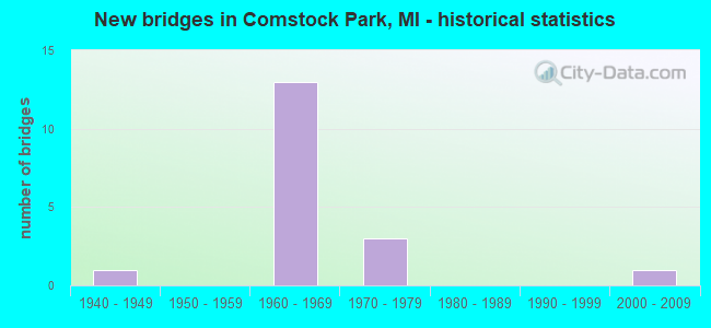
- New bridges - historical statistics
- 11940-1949
- 131960-1969
- 31970-1979
- 12000-2009

- Reconstructed bridges - Historical Statistics
- 11950-1959
- 01960-1969
- 01970-1979
- 01980-1989
- 31990-1999


- Bridge Condition - Deck
- 16.7%Good
- 66.7%Satisfactory
- 16.7%Fair

- Bridge Condition - Superstructure
- 16.7%Very good
- 50.0%Satisfactory
- 33.3%Fair

- Bridge Condition - Substructure
- 16.7%Good
- 16.7%Satisfactory
- 66.7%Fair

- Bridge Condition - Channel
- 12.5%Very good
- 25.0%Good
- 37.5%Satisfactory
- 25.0%Fair

- Bridge Condition - Culverts
- 14.3%Very good
- 42.9%Good
- 28.6%Satisfactory
- 14.3%Fair
Find on map >> Show street view
Structure Number: 4848, Location: 4.0 MI N OF WALKER (Lat: 43.089681, Lng: -85.690042), Route carried "on" structure: State highway 37, Year Built: 1948, Year Reconstructed: 1957, Status: Open, Structure Length: 0.91m (2.99ft), Average Daily Traffic: 16,670 (year 2007), Truck Traffic: 5%, Average Future Daily Traffic: 20,161 (year 2018), Design Load: HS 20, Features Intersected: MILL CREEK
Minimum Vertical Clearance: 30.48m (100.00ft), Kilometerpoint: 12.669, Lanes on structure: 4, Base Highway Network: Yes (Inventory Route: 42, Subroute: 10), Owner: State Highway Agency, Approaching Roadway Width: 12.2m (40.0ft), Skew: 20 degrees, Material/Design: Concrete, Design/Construction: Culvert, Number Of Spans In Main Unit: 1, Length of Maximum Span: 9.1m (29.9ft), Curb-To-Curb Width: 34.8m (114.2ft), Out-to-Out Width: 55.7m (182.7ft)
Condition: Channel: Fair, Culverts: Good, Operating Rating: 97.2 metric tons, Method Used To Determine Operating Rating: Load Factor (LF) rating reported by rating factor (RF) method using MS18 loading, Inventory Rating: 97.2 metric tons, Method Used To Determine Inventory Rating: Load Factor (LF) rating reported by rating factor (RF) method using MS18 loading, Structural Evaluation: Better than present minimum criteria, Deck Geometry: Superior to present desirable criteria, Waterway Adequacy: Equal to present desirable criteria, Approach Roadway Alignment: Better than present minimum criteria, Designated Inspection Frequency: Every 24 months, Inspection Date: April 2021
Find on map >> Show street view
Structure Number: 4984, Location: 0.2 MI N OF WALKER (Lat: 43.032675, Lng: -85.662961), Route carried "on" structure: US 131, Year Built: 1969, Status: Open, Structure Length: 0.70m (2.30ft), Average Daily Traffic: 51,742 (year 2007), Truck Traffic: 7%, Average Future Daily Traffic: 75,750 (year 2018), Design Load: HS 20, Features Intersected: MILL CREEK
Minimum Vertical Clearance: 30.48m (100.00ft), Kilometerpoint: 30.328, Lanes on structure: 4, Base Highway Network: Yes (Inventory Route: 41, Subroute: 3), Owner: State Highway Agency, Approaching Roadway Width: 39.0m (128.0ft), Skew: 20 degrees, Material/Design: Concrete continuous, Design/Construction: Culvert, Number Of Spans In Main Unit: 2, Length of Maximum Span: 3.6m (11.8ft)
Condition: Channel: Satisfactory, Culverts: Satisfactory, Operating Rating: 97.2 metric tons, Method Used To Determine Operating Rating: Load Factor (LF) rating reported by rating factor (RF) method using MS18 loading, Inventory Rating: 97.2 metric tons, Method Used To Determine Inventory Rating: Load Factor (LF) rating reported by rating factor (RF) method using MS18 loading, Structural Evaluation: Equal to present minimum criteria, Waterway Adequacy: Equal to present desirable criteria, Approach Roadway Alignment: Equal to present desirable criteria, Designated Inspection Frequency: Every 24 months, Inspection Date: October 2021, Deck Structure Type: Concrete Cast-file-Place, Wearing Surface/Protective System: Wearing Surface: Integral Concrete, Membrane: Other
Find on map >> Show street view
Structure Number: 4985, Location: 1.3 MI N OF I-96 (Lat: 43.039992, Lng: -85.661742), Route carried "on" structure: US 131, Year Built: 1969, Year Reconstructed: 1998, Status: Open, Structure Length: 14.45m (47.41ft), Average Daily Traffic: 29,425 (year 2007), Truck Traffic: 9%, Average Future Daily Traffic: 32,474 (year 2018), Design Load: HS 20, Features Intersected: W RIVER DR & MDOT RR COR
Minimum Vertical Clearance: 30.48m (100.00ft), Kilometerpoint: 31.306, Lanes on structure: 3, Lanes under structure: 4, Base Highway Network: Yes (Inventory Route: 41, Subroute: 7), Owner: State Highway Agency, Approaching Roadway Width: 14.0m (45.9ft), Skew: 5 degrees, Material/Design: Steel, Design/Construction: Stringer/Multi-beam, Number Of Spans In Main Unit: 6, Length of Maximum Span: 27.4m (89.9ft), Curb-To-Curb Width: 19.5m (64.0ft), Out-to-Out Width: 20.5m (67.3ft)
Condition: Deck: Fair, Superstructure: Fair, Substructure: Satisfactory, Operating Rating: 62.5 metric tons, Method Used To Determine Operating Rating: Load Factor (LF) rating reported by rating factor (RF) method using MS18 loading, Inventory Rating: 37.6 metric tons, Method Used To Determine Inventory Rating: Load Factor (LF) rating reported by rating factor (RF) method using MS18 loading, Structural Evaluation: Somewhat better than minimum adequacy, Deck Geometry: Superior to present desirable criteria, Underclear: Equal to present minimum criteria, Approach Roadway Alignment: Equal to present desirable criteria, Designated Inspection Frequency: Every 24 months, Inspection Date: June 2021, Deck Structure Type: Concrete Cast-file-Place, Wearing Surface/Protective System: Wearing Surface: Latex Concrete, Deck Protection: Epoxy Coated Reinforcing
Find on map >> Show street view
Structure Number: 4986, Location: 1.3 MI N OF I-96 (Lat: 43.040392, Lng: -85.661378), Route carried "on" structure: US 131, Year Built: 1969, Year Reconstructed: 1998, Status: Open, Structure Length: 14.45m (47.41ft), Average Daily Traffic: 29,425 (year 2007), Truck Traffic: 9%, Average Future Daily Traffic: 32,474 (year 2018), Design Load: HS 20, Features Intersected: W RIVER DR & MDOT RR COR
Minimum Vertical Clearance: 30.48m (100.00ft), Kilometerpoint: 31.277, Lanes on structure: 3, Lanes under structure: 4, Base Highway Network: Yes (Inventory Route: 41, Subroute: 3), Owner: State Highway Agency, Approaching Roadway Width: 14.0m (45.9ft), Skew: 5 degrees, Material/Design: Steel, Design/Construction: Stringer/Multi-beam, Number Of Spans In Main Unit: 6, Length of Maximum Span: 27.4m (89.9ft), Curb-To-Curb Width: 19.5m (64.0ft), Out-to-Out Width: 20.5m (67.3ft)
Condition: Deck: Satisfactory, Superstructure: Fair, Substructure: Fair, Operating Rating: 62.5 metric tons, Method Used To Determine Operating Rating: Load Factor (LF) rating reported by rating factor (RF) method using MS18 loading, Inventory Rating: 37.6 metric tons, Method Used To Determine Inventory Rating: Load Factor (LF) rating reported by rating factor (RF) method using MS18 loading, Structural Evaluation: Somewhat better than minimum adequacy, Deck Geometry: Superior to present desirable criteria, Underclear: Somewhat better than minimum adequacy, Approach Roadway Alignment: Equal to present desirable criteria, Designated Inspection Frequency: Every 24 months, Inspection Date: June 2021, Deck Structure Type: Concrete Cast-file-Place, Wearing Surface/Protective System: Wearing Surface: Latex Concrete
Find on map >> Show street view
Structure Number: 4989, Location: 2.4 MI N OF I-96 (Lat: 43.058042, Lng: -85.663417), Route carried "on" structure: US 131, Year Built: 1969, Status: Open, Structure Length: 3.41m (11.19ft), Average Daily Traffic: 29,425 (year 2007), Truck Traffic: 9%, Average Future Daily Traffic: 32,474 (year 2018), Design Load: HS 20, Features Intersected: 6 MILE RD
Minimum Vertical Clearance: 30.48m (100.00ft), Kilometerpoint: 33.250, Lanes on structure: 2, Lanes under structure: 2, Base Highway Network: Yes (Inventory Route: 41, Subroute: 7), Owner: State Highway Agency, Approaching Roadway Width: 12.2m (40.0ft), Material/Design: Prestressed concrete, Design/Construction: Stringer/Multi-beam, Number Of Spans In Main Unit: 3, Length of Maximum Span: 13.7m (44.9ft), Curb or Sidewalk Widths: Left: 0.2m (0.7ft), Right: 0.2m (0.7ft), Curb-To-Curb Width: 12.4m (40.7ft), Out-to-Out Width: 13.1m (43.0ft)
Condition: Deck: Satisfactory, Superstructure: Satisfactory, Substructure: Fair, Operating Rating: 76.5 metric tons, Method Used To Determine Operating Rating: Load Factor (LF) rating reported by rating factor (RF) method using MS18 loading, Inventory Rating: 42.1 metric tons, Method Used To Determine Inventory Rating: Load Factor (LF) rating reported by rating factor (RF) method using MS18 loading, Structural Evaluation: Somewhat better than minimum adequacy, Deck Geometry: Better than present minimum criteria, Underclear: Equal to present minimum criteria, Approach Roadway Alignment: Equal to present desirable criteria, Designated Inspection Frequency: Every 24 months, Inspection Date: October 2021, Deck Structure Type: Concrete Cast-file-Place, Wearing Surface/Protective System: Wearing Surface: Monolithic Concrete
Find on map >> Show street view
Structure Number: 499, Location: 2.4 MI N OF I-96 (Lat: 43.058033, Lng: -85.662694), Route carried "on" structure: US 131, Year Built: 1969, Year Reconstructed: 1998, Status: Open, Structure Length: 3.42m (11.22ft), Average Daily Traffic: 29,425 (year 2007), Truck Traffic: 9%, Average Future Daily Traffic: 32,474 (year 2018), Design Load: HS 20, Features Intersected: 6 MILE RD
Minimum Vertical Clearance: 30.48m (100.00ft), Kilometerpoint: 33.173, Lanes on structure: 2, Lanes under structure: 2, Base Highway Network: Yes (Inventory Route: 41, Subroute: 3), Owner: State Highway Agency, Approaching Roadway Width: 12.2m (40.0ft), Material/Design: Prestressed concrete, Design/Construction: Stringer/Multi-beam, Number Of Spans In Main Unit: 3, Length of Maximum Span: 13.7m (44.9ft), Curb-To-Curb Width: 17.5m (57.4ft), Out-to-Out Width: 18.5m (60.7ft)
Condition: Deck: Good, Superstructure: Satisfactory, Substructure: Fair, Operating Rating: 56.7 metric tons, Method Used To Determine Operating Rating: Load Factor (LF) rating reported by rating factor (RF) method using MS18 loading, Inventory Rating: 26.9 metric tons, Method Used To Determine Inventory Rating: Load Factor (LF) rating reported by rating factor (RF) method using MS18 loading, Structural Evaluation: Somewhat better than minimum adequacy, Deck Geometry: Superior to present desirable criteria, Underclear: Somewhat better than minimum adequacy, Approach Roadway Alignment: Better than present minimum criteria, Designated Inspection Frequency: Every 24 months, Inspection Date: October 2021, Deck Structure Type: Concrete Cast-file-Place, Wearing Surface/Protective System: Wearing Surface: Monolithic Concrete, Deck Protection: Epoxy Coated Reinforcing
Find on map >> Show street view
Structure Number: 4991, Location: 3.4 MI N OF I-96 (Lat: 43.069050, Lng: -85.653922), Route carried "on" structure: County highway , Year Built: 1969, Status: Open, Structure Length: 8.29m (27.20ft), Average Daily Traffic: 4,191 (year 1996), Truck Traffic: 6%, Average Future Daily Traffic: 7,569 (year 2016), Design Load: H 20, Features Intersected: US-131, Facility Carried by Structure: PINE ISLAND DRIVE
Minimum Vertical Clearance: 30.48m (100.00ft), Kilometerpoint: 1.954, Lanes on structure: 2, Lanes under structure: 4, Owner: State Highway Agency, Approaching Roadway Width: 10.9m (35.8ft), Skew: 3 degrees, Material/Design: Steel, Design/Construction: Stringer/Multi-beam, Number Of Spans In Main Unit: 5, Length of Maximum Span: 21.9m (71.9ft), Curb or Sidewalk Widths: Left: 0.7m (2.3ft), Right: 0.7m (2.3ft), Curb-To-Curb Width: 9.1m (29.9ft), Out-to-Out Width: 11.4m (37.4ft)
Condition: Deck: Satisfactory, Superstructure: Satisfactory, Substructure: Good, Operating Rating: 69.5 metric tons, Method Used To Determine Operating Rating: Load Factor (LF), Inventory Rating: 41.6 metric tons, Method Used To Determine Inventory Rating: Load Factor (LF), Structural Evaluation: Equal to present minimum criteria, Deck Geometry: Meets minimum limits, Underclear: Meets minimum limits, Approach Roadway Alignment: Better than present minimum criteria, Designated Inspection Frequency: Every 24 months, Inspection Date: October 2021, Deck Structure Type: Concrete Cast-file-Place, Wearing Surface/Protective System: Wearing Surface: Monolithic Concrete
Find on map >> Show street view
Structure Number: 5025, Location: 350FT NW OF BUD DR (Lat: 43.039569, Lng: -85.670947), Route carried "on" structure: County highway 2001, Year Built: 1969, Status: Open, Structure Length: 1.03m (3.38ft), Average Daily Traffic: 9,239 (year 2004), Average Future Daily Traffic: 15,710 (year 2024), Design Load: HS 20+Mod, Features Intersected: INDIAN MILL CREEK, Facility Carried by Structure: LAMOREAUX DRIVE
Minimum Vertical Clearance: 30.48m (100.00ft), Kilometerpoint: 1.759, Lanes on structure: 4, Owner: County Highway Agency, Approaching Roadway Width: 13.1m (43.0ft), Material/Design: Steel, Design/Construction: Culvert, Number Of Spans In Main Unit: 2, Length of Maximum Span: 4.5m (14.8ft)
Condition: Channel: Good, Culverts: Good, Operating Rating: 97.2 metric tons, Method Used To Determine Operating Rating: Load Factor (LF) rating reported by rating factor (RF) method using MS18 loading, Inventory Rating: 97.2 metric tons, Method Used To Determine Inventory Rating: Load Factor (LF) rating reported by rating factor (RF) method using MS18 loading, Structural Evaluation: Better than present minimum criteria, Waterway Adequacy: Equal to present desirable criteria, Approach Roadway Alignment: Equal to present desirable criteria, Designated Inspection Frequency: Every 24 months, Inspection Date: October 2021
Find on map >> Show street view
Structure Number: 5052, Location: 0.05 MI S OF LAMOREAUX DR (Lat: 43.033500, Lng: -85.666211), Route carried "on" structure: County highway 2001, Year Built: 2002, Status: Open, Structure Length: 1.09m (3.58ft), Average Daily Traffic: 26,226 (year 2005), Average Future Daily Traffic: 44,580 (year 2025), Design Load: HS 20+Mod, Features Intersected: INDIAN MILL CREEK, Facility Carried by Structure: WEST RIVER DRIVE
Minimum Vertical Clearance: 30.48m (100.00ft), Kilometerpoint: 3.032, Lanes on structure: 4, Owner: County Highway Agency, Approaching Roadway Width: 13.1m (43.0ft), Material/Design: Prestressed concrete, Design/Construction: Box Beam or Girders - Multiple, Number Of Spans In Main Unit: 1, Length of Maximum Span: 9.4m (30.8ft), Curb or Sidewalk Widths: Left: 1.8m (5.9ft), Right: 6.9m (22.6ft), Curb-To-Curb Width: 13.1m (43.0ft), Out-to-Out Width: 22.4m (73.5ft)
Condition: Deck: Satisfactory, Superstructure: Very good, Substructure: Fair, Channel: Very good, Operating Rating: 81.8 metric tons, Method Used To Determine Operating Rating: Load Factor (LF), Inventory Rating: 36.2 metric tons, Method Used To Determine Inventory Rating: Load Factor (LF), Structural Evaluation: Somewhat better than minimum adequacy, Deck Geometry: High priority of replacement, Waterway Adequacy: Equal to present minimum criteria, Approach Roadway Alignment: Equal to present minimum criteria, Designated Inspection Frequency: Every 24 months, Inspection Date: November 2021, Deck Structure Type: Concrete Cast-file-Place, Wearing Surface/Protective System: Wearing Surface: Monolithic Concrete
Find on map >> Show street view
Structure Number: 5086, Location: 0.10 MI W OF DIVISON AVE (Lat: 43.058197, Lng: -85.672150), Route carried "on" structure: County highway , Year Built: 1977, Status: Open, Structure Length: 0.94m (3.08ft), Average Daily Traffic: 5,544 (year 2004), Average Future Daily Traffic: 9,420 (year 2024), Design Load: HS 20+Mod, Features Intersected: MILL CREEK, Facility Carried by Structure: 6 MILE ROAD
Minimum Vertical Clearance: 30.48m (100.00ft), Kilometerpoint: 9.452, Lanes on structure: 2, Owner: County Highway Agency, Approaching Roadway Width: 12.2m (40.0ft), Skew: 3 degrees, Material/Design: Steel, Design/Construction: Culvert, Number Of Spans In Main Unit: 2, Length of Maximum Span: 4.5m (14.8ft)
Condition: Channel: Good, Culverts: Fair, Operating Rating: 65.8 metric tons, Method Used To Determine Operating Rating: Load Factor (LF) rating reported by rating factor (RF) method using MS18 loading, Inventory Rating: 61.6 metric tons, Method Used To Determine Inventory Rating: Load Factor (LF) rating reported by rating factor (RF) method using MS18 loading, Structural Evaluation: Somewhat better than minimum adequacy, Waterway Adequacy: Equal to present desirable criteria, Approach Roadway Alignment: Equal to present desirable criteria, Designated Inspection Frequency: Every 24 months, Inspection Date: October 2021
Find on map >> Show street view
Structure Number: 5113, Location: 300 FT EAST OF M-37 (Lat: 43.087264, Lng: -85.688583), Route carried "on" structure: County highway , Year Built: 1969, Status: Open, Structure Length: 0.88m (2.89ft), Average Daily Traffic: 763 (year 2004), Average Future Daily Traffic: 1,300 (year 2024), Design Load: HS 20+Mod, Features Intersected: MILL CREEK, Facility Carried by Structure: 8 MILE ROAD
Minimum Vertical Clearance: 30.48m (100.00ft), Kilometerpoint: 8.139, Lanes on structure: 2, Owner: County Highway Agency, Approaching Roadway Width: 6.7m (22.0ft), Material/Design: Steel, Design/Construction: Culvert, Number Of Spans In Main Unit: 2, Length of Maximum Span: 4.2m (13.8ft)
Condition: Channel: Satisfactory, Culverts: Satisfactory, Operating Rating: 39.5 metric tons, Method Used To Determine Operating Rating: Load Factor (LF) rating reported by rating factor (RF) method using MS18 loading, Inventory Rating: 32.7 metric tons, Method Used To Determine Inventory Rating: Load Factor (LF) rating reported by rating factor (RF) method using MS18 loading, Structural Evaluation: Equal to present minimum criteria, Waterway Adequacy: Equal to present desirable criteria, Approach Roadway Alignment: Equal to present desirable criteria, Designated Inspection Frequency: Every 24 months, Inspection Date: October 2021
Find on map >> Show street view
Structure Number: 5115, Location: 0.45 MI N OF 7 MILE RD (Lat: 43.078311, Lng: -85.680433), Route carried "on" structure: County highway , Year Built: 1972, Status: Open, Structure Length: 0.91m (2.99ft), Average Daily Traffic: 684 (year 2004), Average Future Daily Traffic: 1,160 (year 2024), Design Load: HS 20+Mod, Features Intersected: MILL CREEK, Facility Carried by Structure: VINTON AVE
Minimum Vertical Clearance: 30.48m (100.00ft), Kilometerpoint: 1.460, Lanes on structure: 2, Owner: County Highway Agency, Approaching Roadway Width: 6.7m (22.0ft), Skew: 1 degrees, Material/Design: Steel, Design/Construction: Culvert, Number Of Spans In Main Unit: 2, Length of Maximum Span: 4.5m (14.8ft)
Condition: Channel: Fair, Culverts: Good, Operating Rating: 55.4 metric tons, Method Used To Determine Operating Rating: Load Factor (LF) rating reported by rating factor (RF) method using MS18 loading, Inventory Rating: 49.6 metric tons, Method Used To Determine Inventory Rating: Load Factor (LF) rating reported by rating factor (RF) method using MS18 loading, Structural Evaluation: Better than present minimum criteria, Waterway Adequacy: Equal to present desirable criteria, Approach Roadway Alignment: Equal to present minimum criteria, Designated Inspection Frequency: Every 24 months, Inspection Date: October 2021
Find on map >> Show street view
Structure Number: 5116, Location: 0.10 MI N OF HAYES (Lat: 43.081703, Lng: -85.679903), Route carried "on" structure: County highway , Year Built: 1979, Status: Open, Structure Length: 0.82m (2.69ft), Average Daily Traffic: 684 (year 2004), Average Future Daily Traffic: 1,160 (year 2024), Design Load: HS 20+Mod, Features Intersected: UNNAMED CREEK, Facility Carried by Structure: VINTON AVE
Minimum Vertical Clearance: 30.48m (100.00ft), Kilometerpoint: 1.841, Lanes on structure: 2, Owner: County Highway Agency, Approaching Roadway Width: 6.7m (22.0ft), Material/Design: Steel, Design/Construction: Culvert, Number Of Spans In Main Unit: 3, Length of Maximum Span: 2.1m (6.9ft)
Condition: Channel: Satisfactory, Culverts: Very good, Operating Rating: 72.9 metric tons, Method Used To Determine Operating Rating: Load Factor (LF) rating reported by rating factor (RF) method using MS18 loading, Inventory Rating: 69.7 metric tons, Method Used To Determine Inventory Rating: Load Factor (LF) rating reported by rating factor (RF) method using MS18 loading, Structural Evaluation: Equal to present desirable criteria, Waterway Adequacy: Equal to present desirable criteria, Approach Roadway Alignment: Equal to present desirable criteria, Designated Inspection Frequency: Every 24 months, Inspection Date: October 2021
Find on map >> Show street view
Structure Number: 4985, Location: 1.3 MI N OF I-96 (Lat: 43.039992, Lng: -85.661742), Route carried "under" structure: County highway 4199, Year Built: 1969, Structure Length: 0. m, Average Daily Traffic: 19,078 (year 1996), Truck Traffic: 10%, Features Intersected: W RIVER DR & MDOT RR COR, Facility Carried by Structure: US-131 SB
Minimum Vertical Clearance: 6.07m (19.91ft), Kilometerpoint: 3.900, Lanes on structure: 3, Lanes under structure: 4, Material/Design: Steel, Design/Construction: Stringer/Multi-beam, Length of Maximum Span: 27.4m (89.9ft)
Find on map >> Show street view
Structure Number: 4986, Location: 1.3 MI N OF I-96 (Lat: 43.040392, Lng: -85.661378), Route carried "under" structure: County highway 4199, Year Built: 1969, Structure Length: 0. m, Average Daily Traffic: 19,078 (year 1996), Truck Traffic: 10%, Features Intersected: W RIVER DR & MDOT RR COR, Facility Carried by Structure: US-131 NB
Minimum Vertical Clearance: 6.10m (20.01ft), Kilometerpoint: 3.951, Lanes on structure: 3, Lanes under structure: 4, Material/Design: Steel, Design/Construction: Stringer/Multi-beam, Length of Maximum Span: 27.4m (89.9ft)
Find on map >> Show street view
Structure Number: 4989, Location: 2.4 MI N OF I-96 (Lat: 43.058042, Lng: -85.663417), Route carried "under" structure: County highway 2001, Year Built: 1969, Structure Length: 0. m, Average Daily Traffic: 3,917 (year 1997), Truck Traffic: 6%, Features Intersected: 6 MILE RD, Facility Carried by Structure: US-131 SB
Minimum Vertical Clearance: 4.44m (14.57ft), Kilometerpoint: 10.163, Lanes on structure: 2, Lanes under structure: 2, Material/Design: Prestressed concrete, Design/Construction: Stringer/Multi-beam, Length of Maximum Span: 13.7m (44.9ft)
Find on map >> Show street view
Structure Number: 499, Location: 2.4 MI N OF I-96 (Lat: 43.058033, Lng: -85.662694), Route carried "under" structure: County highway 2001, Year Built: 1969, Structure Length: 0. m, Average Daily Traffic: 3,417 (year 1997), Truck Traffic: 6%, Features Intersected: 6 MILE RD, Facility Carried by Structure: US-131 NB
Minimum Vertical Clearance: 4.34m (14.24ft), Kilometerpoint: 10.223, Lanes on structure: 2, Lanes under structure: 2, Material/Design: Prestressed concrete, Design/Construction: Stringer/Multi-beam, Length of Maximum Span: 13.7m (44.9ft)
Find on map >> Show street view
Structure Number: 4991, Location: 3.4 MI N OF I-96 (Lat: 43.069050, Lng: -85.653922), Route carried "under" structure: US 131, Year Built: 1969, Structure Length: 0. m, Average Daily Traffic: 58,850 (year 2007), Truck Traffic: 9%, Features Intersected: US-131, Facility Carried by Structure: PINE ISLAND DRIVE
Minimum Vertical Clearance: 4.67m (15.32ft), Kilometerpoint: 34.707, Lanes on structure: 2, Lanes under structure: 4, Material/Design: Steel, Design/Construction: Stringer/Multi-beam, Length of Maximum Span: 21.9m (71.9ft)