Bridge Statistics for Clermont, Florida (FL)
Condition, Traffic, Stress, Structural Evaluation, Project Costs
- National Bridge Inventory (NBI) Statistics
- 23Number of bridges
- 223ft / 67.8mTotal length
- 365,751Total average daily traffic
- 61,199Total average daily truck traffic
- National Bridge Inventory (NBI) Registered Bridges for Clermont
- No street view available for this location
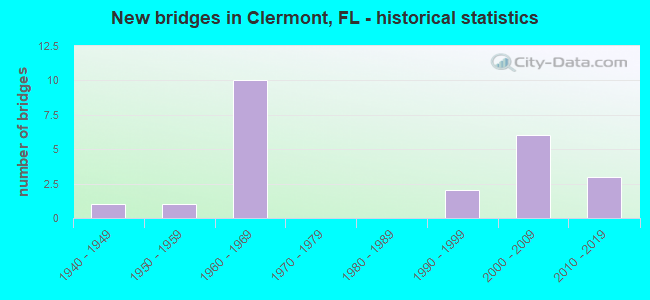
- New bridges - historical statistics
- 11940-1949
- 11950-1959
- 101960-1969
- 21990-1999
- 62000-2009
- 32010-2019


- Bridge Condition - Deck
- 38.5%Very good
- 38.5%Good
- 23.1%Satisfactory

- Bridge Condition - Superstructure
- 30.8%Very good
- 53.8%Good
- 15.4%Satisfactory

- Bridge Condition - Substructure
- 30.8%Very good
- 53.8%Good
- 15.4%Satisfactory

- Bridge Condition - Channel
- 28.6%Very good
- 71.4%Good

- Bridge Condition - Culverts
- 50.0%Good
- 50.0%Satisfactory
Find on map >> Show street view
Structure Number: 110032, Location: 1.2MI N OF ORANGE CO LINE (Lat: 28.558756, Lng: -81.677094), Route carried "on" structure: State highway 91, Year Built: 1964, Year Reconstructed: 1991, Status: Open, Structure Length: 8.98m (29.46ft), Average Daily Traffic: 30,550 (year 2020), Truck Traffic: 21%, Average Future Daily Traffic: 53,004 (year 2042), Design Load: HS 20+Mod, Features Intersected: SR 438
Minimum Vertical Clearance: 30+ m (98+ ft), Kilometerpoint: 1.997, Lanes on structure: 2, Lanes under structure: 2, Base Highway Network: Yes, Toll: On toll road, Owner: State Toll Authority, Approaching Roadway Width: 12.2m (40.0ft), Skew: 5 degrees, Material/Design: Prestressed concrete, Design/Construction: Stringer/Multi-beam, Number Of Spans In Main Unit: 4, Length of Maximum Span: 23.5m (77.1ft), Curb-To-Curb Width: 12.3m (40.4ft), Out-to-Out Width: 13.2m (43.3ft)
Condition: Deck: Good, Superstructure: Good, Substructure: Good, Operating Rating: 34.9 metric tons, Method Used To Determine Operating Rating: Load and Resistance Factor (LRFR), Inventory Rating: 26.9 metric tons, Method Used To Determine Inventory Rating: Load and Resistance Factor (LRFR), Structural Evaluation: Equal to present minimum criteria, Deck Geometry: Better than present minimum criteria, Underclear: Meets minimum limits, Approach Roadway Alignment: Equal to present desirable criteria, Designated Inspection Frequency: Every 24 months, Inspection Date: October 2021, Deck Structure Type: Concrete Cast-file-Place
Find on map >> Show street view
Structure Number: 110033, Location: 3.1MI N OF ORANGE CO LINE (Lat: 28.575967, Lng: -81.700233), Route carried "on" structure: State highway 91, Year Built: 1964, Status: Open, Structure Length: 4.01m (13.16ft), Average Daily Traffic: 30,550 (year 2020), Truck Traffic: 21%, Average Future Daily Traffic: 53,004 (year 2042), Design Load: HS 20+Mod, Features Intersected: BLACKSTILL LAKE RD
Minimum Vertical Clearance: 30.45m (99.90ft), Kilometerpoint: 5.003, Lanes on structure: 2, Lanes under structure: 2, Base Highway Network: Yes, Toll: On toll road, Owner: State Toll Authority, Approaching Roadway Width: 11.9m (39.0ft), Skew: 3 degrees, Material/Design: Prestressed concrete, Design/Construction: Stringer/Multi-beam, Number Of Spans In Main Unit: 3, Length of Maximum Span: 13.7m (44.9ft), Curb or Sidewalk Widths: Left: 0.6m (2.0ft), Right: 0.6m (2.0ft), Curb-To-Curb Width: 11.6m (38.1ft), Out-to-Out Width: 13.4m (44.0ft)
Condition: Deck: Very good, Superstructure: Good, Substructure: Good, Operating Rating: 42.6 metric tons, Method Used To Determine Operating Rating: Load and Resistance Factor (LRFR), Inventory Rating: 32.8 metric tons, Method Used To Determine Inventory Rating: Load and Resistance Factor (LRFR), Structural Evaluation: Better than present minimum criteria, Deck Geometry: Equal to present minimum criteria, Underclear: Meets minimum limits, Approach Roadway Alignment: Equal to present desirable criteria, Designated Inspection Frequency: Every 24 months, Inspection Date: October 2021, Deck Structure Type: Concrete Cast-file-Place, Wearing Surface/Protective System: Wearing Surface: Bituminous
Find on map >> Show street view
Structure Number: 110037, Location: 1.2MI N OF ORANGE CO LINE (Lat: 28.559025, Lng: -81.677275), Route carried "on" structure: State highway 91, Year Built: 1964, Year Reconstructed: 1991, Status: Open, Structure Length: 8.98m (29.46ft), Average Daily Traffic: 30,550 (year 2020), Truck Traffic: 21%, Average Future Daily Traffic: 53,004 (year 2042), Design Load: HS 20+Mod, Features Intersected: SR 438
Minimum Vertical Clearance: 30+ m (98+ ft), Kilometerpoint: 2.029, Lanes on structure: 2, Lanes under structure: 2, Base Highway Network: Yes, Toll: On toll road, Owner: State Toll Authority, Approaching Roadway Width: 11.0m (36.1ft), Skew: 5 degrees, Material/Design: Prestressed concrete, Design/Construction: Stringer/Multi-beam, Number Of Spans In Main Unit: 4, Length of Maximum Span: 23.5m (77.1ft), Curb-To-Curb Width: 12.3m (40.4ft), Out-to-Out Width: 13.2m (43.3ft)
Condition: Deck: Satisfactory, Superstructure: Satisfactory, Substructure: Good, Operating Rating: 34.9 metric tons, Method Used To Determine Operating Rating: Load and Resistance Factor (LRFR), Inventory Rating: 26.9 metric tons, Method Used To Determine Inventory Rating: Load and Resistance Factor (LRFR), Structural Evaluation: Equal to present minimum criteria, Deck Geometry: Better than present minimum criteria, Underclear: Meets minimum limits, Approach Roadway Alignment: Equal to present desirable criteria, Designated Inspection Frequency: Every 24 months, Inspection Date: October 2021, Deck Structure Type: Concrete Cast-file-Place
Find on map >> Show street view
Structure Number: 110038, Location: 3.1MI N OF ORANGE CO LINE (Lat: 28.575978, Lng: -81.699994), Route carried "on" structure: State highway 91, Year Built: 1964, Status: Open, Structure Length: 4.02m (13.19ft), Average Daily Traffic: 30,550 (year 2020), Truck Traffic: 21%, Average Future Daily Traffic: 53,004 (year 2042), Design Load: HS 20+Mod, Features Intersected: BLACKSTILL LAKE RD
Minimum Vertical Clearance: 30+ m (98+ ft), Kilometerpoint: 4.997, Lanes on structure: 2, Lanes under structure: 2, Base Highway Network: Yes, Toll: On toll road, Owner: State Toll Authority, Approaching Roadway Width: 11.9m (39.0ft), Skew: 3 degrees, Material/Design: Prestressed concrete, Design/Construction: Stringer/Multi-beam, Number Of Spans In Main Unit: 3, Length of Maximum Span: 13.7m (44.9ft), Curb or Sidewalk Widths: Left: 0.6m (2.0ft), Right: 0.6m (2.0ft), Curb-To-Curb Width: 11.6m (38.1ft), Out-to-Out Width: 13.4m (44.0ft)
Condition: Deck: Satisfactory, Superstructure: Satisfactory, Substructure: Satisfactory, Operating Rating: 42.6 metric tons, Method Used To Determine Operating Rating: Load and Resistance Factor (LRFR), Inventory Rating: 32.8 metric tons, Method Used To Determine Inventory Rating: Load and Resistance Factor (LRFR), Structural Evaluation: Equal to present minimum criteria, Deck Geometry: Equal to present minimum criteria, Underclear: Meets minimum limits, Approach Roadway Alignment: Equal to present desirable criteria, Designated Inspection Frequency: Every 24 months, Inspection Date: October 2021, Deck Structure Type: Concrete Cast-file-Place
Find on map >> Show street view
Structure Number: 110052, Location: 1.6MI N OF ORANGE CO LINE (Lat: 28.560900, Lng: -81.682250), Route carried "on" structure: County highway 455, Year Built: 1964, Status: Open, Structure Length: 6.60m (21.65ft), Average Daily Traffic: 6,800 (year 2020), Truck Traffic: 7%, Average Future Daily Traffic: 11,798 (year 2042), Design Load: HS 20+Mod, Features Intersected: SR 91 TPK
Minimum Vertical Clearance: 30+ m (98+ ft), Kilometerpoint: 1.588, Lanes on structure: 2, Lanes under structure: 4, Owner: State Toll Authority, Approaching Roadway Width: 7.7m (25.3ft), Skew: 3 degrees, Material/Design: Prestressed concrete, Design/Construction: Stringer/Multi-beam, Number Of Spans In Main Unit: 4, Length of Maximum Span: 20.0m (65.6ft), Curb or Sidewalk Widths: Left: 0.6m (2.0ft), Right: 0.6m (2.0ft), Curb-To-Curb Width: 8.5m (27.9ft), Out-to-Out Width: 10.3m (33.8ft)
Condition: Deck: Satisfactory, Superstructure: Good, Substructure: Good, Operating Rating: 34.7 metric tons, Method Used To Determine Operating Rating: Load and Resistance Factor (LRFR), Inventory Rating: 26.8 metric tons, Method Used To Determine Inventory Rating: Load and Resistance Factor (LRFR), Structural Evaluation: Equal to present minimum criteria, Deck Geometry: Meets minimum limits, Underclear: High priority of corrective action, Approach Roadway Alignment: Equal to present desirable criteria, Designated Inspection Frequency: Every 24 months, Inspection Date: October 2021, Deck Structure Type: Concrete Cast-file-Place
Find on map >> Show street view
Structure Number: 110087, Location: US-27 SB - Pitt Street (Lat: 28.557606, Lng: -81.743486), Route carried "on" structure: US 27, Year Built: 2008, Status: Open, Structure Length: 2.90m (9.51ft), Average Daily Traffic: 13,000 (year 2020), Truck Traffic: 10%, Average Future Daily Traffic: 22,555 (year 2042), Design Load: HL 93, Features Intersected: Pitt Street
Minimum Vertical Clearance: 30+ m (98+ ft), Kilometerpoint: 24.946, Lanes on structure: 3, Lanes under structure: 2, Base Highway Network: Yes, Owner: State Highway Agency, Approaching Roadway Width: 13.4m (44.0ft), Skew: 1 degrees, Material/Design: Prestressed concrete, Design/Construction: Stringer/Multi-beam, Number Of Spans In Main Unit: 1, Length of Maximum Span: 28.3m (92.8ft), Curb or Sidewalk Widths: Left: 1.5m (4.9ft), Right: 0.0m, Curb-To-Curb Width: 13.4m (44.0ft), Out-to-Out Width: 16.2m (53.1ft)
Condition: Deck: Very good, Superstructure: Very good, Substructure: Very good, Operating Rating: 66.0 metric tons, Method Used To Determine Operating Rating: Load and Resistance Factor (LRFR), Inventory Rating: 61.7 metric tons, Method Used To Determine Inventory Rating: Load and Resistance Factor (LRFR), Structural Evaluation: Equal to present desirable criteria, Deck Geometry: Somewhat better than minimum adequacy, Underclear: Superior to present desirable criteria, Approach Roadway Alignment: Equal to present desirable criteria, Designated Inspection Frequency: Every 24 months, Inspection Date: December 2021, Deck Structure Type: Concrete Cast-file-Place, Wearing Surface/Protective System: Wearing Surface: Monolithic Concrete
Find on map >> Show street view
Structure Number: 110088, Location: US-27 NB - Pitt Street (Lat: 28.557606, Lng: -81.743281), Route carried "on" structure: US 27, Year Built: 2008, Status: Open, Structure Length: 2.90m (9.51ft), Average Daily Traffic: 13,000 (year 2020), Truck Traffic: 10%, Average Future Daily Traffic: 22,555 (year 2042), Design Load: HL 93, Features Intersected: Pitt Street
Minimum Vertical Clearance: 30+ m (98+ ft), Kilometerpoint: 24.948, Lanes on structure: 3, Lanes under structure: 2, Base Highway Network: Yes, Owner: State Highway Agency, Approaching Roadway Width: 13.4m (44.0ft), Skew: 1 degrees, Material/Design: Prestressed concrete, Design/Construction: Stringer/Multi-beam, Number Of Spans In Main Unit: 1, Length of Maximum Span: 28.3m (92.8ft), Curb or Sidewalk Widths: Left: 0.0m, Right: 1.5m (4.9ft), Curb-To-Curb Width: 13.4m (44.0ft), Out-to-Out Width: 16.2m (53.1ft)
Condition: Deck: Very good, Superstructure: Good, Substructure: Very good, Operating Rating: 66.0 metric tons, Method Used To Determine Operating Rating: Load and Resistance Factor (LRFR), Inventory Rating: 61.7 metric tons, Method Used To Determine Inventory Rating: Load and Resistance Factor (LRFR), Structural Evaluation: Better than present minimum criteria, Deck Geometry: Somewhat better than minimum adequacy, Underclear: Superior to present desirable criteria, Approach Roadway Alignment: Equal to present desirable criteria, Designated Inspection Frequency: Every 24 months, Inspection Date: December 2021, Deck Structure Type: Concrete Cast-file-Place, Wearing Surface/Protective System: Wearing Surface: Monolithic Concrete
Find on map >> Show street view
Structure Number: 110093, Location: US -27 over SR-50 (Lat: 28.547333, Lng: -81.742056), Route carried "on" structure: State highway 27, Year Built: 2013, Status: Open, Structure Length: 5.19m (17.03ft), Average Daily Traffic: 26,000 (year 2020), Truck Traffic: 10%, Average Future Daily Traffic: 45,110 (year 2042), Design Load: HL 93, Features Intersected: SR-50
Minimum Vertical Clearance: 30+ m (98+ ft), Kilometerpoint: 23.768, Lanes on structure: 10, Lanes under structure: 8, Base Highway Network: Yes, Owner: State Highway Agency, Approaching Roadway Width: 52.4m (171.9ft), Skew: 31 degrees, Material/Design: Prestressed concrete, Design/Construction: Stringer/Multi-beam, Number Of Spans In Main Unit: 2, Length of Maximum Span: 26.1m (85.6ft), Curb-To-Curb Width: 52.4m (171.9ft), Out-to-Out Width: 56.4m (185.0ft)
Condition: Deck: Very good, Superstructure: Very good, Substructure: Very good, Operating Rating: 39.8 metric tons, Method Used To Determine Operating Rating: Load and Resistance Factor (LRFR), Inventory Rating: 35.9 metric tons, Method Used To Determine Inventory Rating: Load and Resistance Factor (LRFR), Structural Evaluation: Equal to present desirable criteria, Deck Geometry: Superior to present desirable criteria, Underclear: Meets minimum limits, Approach Roadway Alignment: Equal to present desirable criteria, Designated Inspection Frequency: Every 24 months, Inspection Date: October 2021, Deck Structure Type: Concrete Cast-file-Place, Wearing Surface/Protective System: Wearing Surface: Monolithic Concrete
Find on map >> Show street view
Structure Number: 114045, Location: 2.4 MI W of US-27 (Lat: 28.581264, Lng: -81.787089), Route carried "on" structure: County highway 561, Year Built: 1958, Status: Open, Structure Length: 4.88m (16.01ft), Average Daily Traffic: 3,900 (year 2021), Truck Traffic: 10%, Average Future Daily Traffic: 6,767 (year 2042), Design Load: H 15, Features Intersected: Crystal Cove
Minimum Vertical Clearance: 30+ m (98+ ft), Kilometerpoint: 3.388, Lanes on structure: 2, Owner: County Highway Agency, Approaching Roadway Width: 7.0m (23.0ft), Material/Design: Concrete, Design/Construction: Slab, Number Of Spans In Main Unit: 8, Length of Maximum Span: 6.1m (20.0ft), Curb or Sidewalk Widths: Left: 0.2m (0.7ft), Right: 0.2m (0.7ft), Curb-To-Curb Width: 7.3m (24.0ft), Out-to-Out Width: 7.8m (25.6ft)
Condition: Deck: Good, Superstructure: Good, Substructure: Satisfactory, Channel: Good, Operating Rating: 57.0 metric tons, Method Used To Determine Operating Rating: Load Factor (LF), Inventory Rating: 34.2 metric tons, Method Used To Determine Inventory Rating: Load Factor (LF), Structural Evaluation: Equal to present minimum criteria, Deck Geometry: High priority of replacement, Waterway Adequacy: Somewhat better than minimum adequacy, Approach Roadway Alignment: Equal to present desirable criteria, Designated Inspection Frequency: Every 24 months, Underwater Inspection Frequency: Every 24 months, Inspection Date: August 2021, Underwater Inspection Date: August 2021, Deck Structure Type: Concrete Cast-file-Place
Find on map >> Show street view
Structure Number: 114078, Location: 0.8 MILE EAST OF CR-561 (Lat: 28.515753, Lng: -81.771364), Route carried "on" structure: County highway , Year Built: 1940, Status: Posted for load, Structure Length: 0.61m (2.00ft), Average Daily Traffic: 1,501 (year 2021), Truck Traffic: 5%, Average Future Daily Traffic: 2,001 (year 2042), Design Load: HS 20, Features Intersected: Crescent Lake Canal, Facility Carried by Structure: Bronson Rd.
Minimum Vertical Clearance: 30+ m (98+ ft), Kilometerpoint: 1.331, Lanes on structure: 2, Owner: County Highway Agency, Approaching Roadway Width: 5.8m (19.0ft), Material/Design: Steel, Design/Construction: Culvert, Number Of Spans In Main Unit: 1, Length of Maximum Span: 6.1m (20.0ft)
Condition: Channel: Good, Culverts: Satisfactory, Structural Evaluation: Equal to present minimum criteria, Waterway Adequacy: Better than present minimum criteria, Approach Roadway Alignment: High priority of replacement, Designated Inspection Frequency: Every 24 months, Underwater Inspection Frequency: Every 24 months, Inspection Date: August 2021, Underwater Inspection Date: August 2021
Find on map >> Show street view
Structure Number: 114091, Location: 0.9 MI NORTH OF SR-50 (Lat: 28.565653, Lng: -81.777047), Route carried "on" structure: Alternate County highway 561A, Year Built: 1999, Status: Open, Structure Length: 4.33m (14.21ft), Average Daily Traffic: 3,900 (year 2021), Truck Traffic: 10%, Average Future Daily Traffic: 6,767 (year 2042), Design Load: HS 20+Mod, Features Intersected: LAKE MINNEOLA
Minimum Vertical Clearance: 30+ m (98+ ft), Kilometerpoint: 1.048, Lanes on structure: 2, Owner: County Highway Agency, Approaching Roadway Width: 7.3m (24.0ft), Material/Design: Prestressed concrete, Design/Construction: Stringer/Multi-beam, Number Of Spans In Main Unit: 3, Length of Maximum Span: 14.2m (46.6ft), Curb or Sidewalk Widths: Left: 0.0m, Right: 3.0m (9.8ft), Curb-To-Curb Width: 12.0m (39.4ft), Out-to-Out Width: 16.2m (53.1ft)
Condition: Deck: Good, Superstructure: Good, Substructure: Good, Channel: Very good, Operating Rating: 53.3 metric tons, Method Used To Determine Operating Rating: Load and Resistance Factor (LRFR), Inventory Rating: 41.2 metric tons, Method Used To Determine Inventory Rating: Load and Resistance Factor (LRFR), Structural Evaluation: Better than present minimum criteria, Deck Geometry: Somewhat better than minimum adequacy, Waterway Adequacy: Better than present minimum criteria, Approach Roadway Alignment: Equal to present desirable criteria, Designated Inspection Frequency: Every 24 months, Underwater Inspection Frequency: Every 24 months, Inspection Date: August 2021, Underwater Inspection Date: August 2021, Deck Structure Type: Concrete Cast-file-Place
Find on map >> Show street view
Structure Number: 114092, Location: 1.0 MI SW OF SR-50 (Lat: 28.544047, Lng: -81.783708), Route carried "on" structure: County highway 561, Year Built: 1999, Status: Open, Structure Length: 7.38m (24.21ft), Average Daily Traffic: 1,100 (year 2021), Truck Traffic: 7%, Average Future Daily Traffic: 1,909 (year 2042), Design Load: HS 20, Features Intersected: Lake Minnehaha Canal
Minimum Vertical Clearance: 30+ m (98+ ft), Kilometerpoint: 17.281, Lanes on structure: 2, Owner: County Highway Agency, Approaching Roadway Width: 7.3m (24.0ft), Material/Design: Prestressed concrete, Design/Construction: Stringer/Multi-beam, Number Of Spans In Main Unit: 5, Length of Maximum Span: 14.6m (47.9ft), Curb-To-Curb Width: 12.0m (39.4ft), Out-to-Out Width: 13.0m (42.7ft)
Condition: Deck: Good, Superstructure: Very good, Substructure: Good, Channel: Good, Operating Rating: 83.5 metric tons, Method Used To Determine Operating Rating: Load Factor (LF), Inventory Rating: 49.9 metric tons, Method Used To Determine Inventory Rating: Load Factor (LF), Structural Evaluation: Better than present minimum criteria, Deck Geometry: Equal to present minimum criteria, Waterway Adequacy: Better than present minimum criteria, Approach Roadway Alignment: Better than present minimum criteria, Designated Inspection Frequency: Every 24 months, Underwater Inspection Frequency: Every 24 months, Inspection Date: August 2021, Underwater Inspection Date: August 2021, Deck Structure Type: Concrete Cast-file-Place
Find on map >> Show street view
Structure Number: 114096, Location: 2.3 Miles East of CR-561 (Lat: 28.461244, Lng: -81.757317), Route carried "on" structure: County highway , Year Built: 2004, Status: Open, Structure Length: 0.97m (3.18ft), Average Daily Traffic: 100 (year 2021), Truck Traffic: 1%, Average Future Daily Traffic: 125 (year 2042), Design Load: HS 20, Features Intersected: Little Creek, Facility Carried by Structure: Lake Nellie Road
Minimum Vertical Clearance: 30+ m (98+ ft), Kilometerpoint: 0.000, Lanes on structure: 2, Owner: County Highway Agency, Approaching Roadway Width: 7.5m (24.6ft), Material/Design: Concrete, Design/Construction: Culvert, Number Of Spans In Main Unit: 3, Length of Maximum Span: 3.1m (10.2ft)
Condition: Channel: Good, Culverts: Good, Inventory Rating: 62.8 metric tons, Method Used To Determine Inventory Rating: Load Factor (LF), Structural Evaluation: Better than present minimum criteria, Waterway Adequacy: Better than present minimum criteria, Approach Roadway Alignment: Equal to present minimum criteria, Designated Inspection Frequency: Every 24 months, Underwater Inspection Frequency: Every 24 months, Inspection Date: March 2021, Underwater Inspection Date: March 2021
Find on map >> Show street view
Structure Number: 114098, Location: 2.25 Mi West of US 27 (Lat: 28.520381, Lng: -81.756014), Route carried "on" structure: County highway 1040A, Year Built: 2012, Status: Open, Structure Length: 3.66m (12.01ft), Average Daily Traffic: 3,000 (year 2020), Truck Traffic: 10%, Average Future Daily Traffic: 5,205 (year 2042), Design Load: HL 93, Features Intersected: Palatlakaha River, Facility Carried by Structure: Lakeshore Drive
Minimum Vertical Clearance: 30+ m (98+ ft), Kilometerpoint: 5.769, Lanes on structure: 2, Owner: County Highway Agency, Approaching Roadway Width: 12.2m (40.0ft), Material/Design: Prestressed concrete, Design/Construction: Stringer/Multi-beam, Number Of Spans In Main Unit: 1, Length of Maximum Span: 36.6m (120.1ft), Curb or Sidewalk Widths: Left: 2.4m (7.9ft), Right: 0.0m, Curb-To-Curb Width: 12.2m (40.0ft), Out-to-Out Width: 15.8m (51.8ft)
Condition: Deck: Very good, Superstructure: Very good, Substructure: Very good, Channel: Good, Operating Rating: 46.1 metric tons, Method Used To Determine Operating Rating: Load and Resistance Factor (LRFR), Inventory Rating: 41.5 metric tons, Method Used To Determine Inventory Rating: Load and Resistance Factor (LRFR), Structural Evaluation: Equal to present desirable criteria, Deck Geometry: Equal to present minimum criteria, Waterway Adequacy: Better than present minimum criteria, Approach Roadway Alignment: Equal to present desirable criteria, Designated Inspection Frequency: Every 24 months, Underwater Inspection Frequency: Every 24 months, Inspection Date: June 2020, Underwater Inspection Date: June 2020, Deck Structure Type: Concrete Cast-file-Place
Find on map >> Show street view
Structure Number: 118002, Location: 2 Miles W of US-27 (Lat: 28.447297, Lng: -81.740331), Route carried "on" structure: State lands road , Year Built: 2001, Status: Open, Structure Length: 2.34m (7.68ft), Average Daily Traffic: 50 (year 2011), Truck Traffic: 5%, Average Future Daily Traffic: 105 (year 2033), Design Load: HS 25 or greater, Features Intersected: Big Creek, Facility Carried by Structure: Lake Louisa Rd.
Minimum Vertical Clearance: 30+ m (98+ ft), Kilometerpoint: 0.000, Lanes on structure: 2, Owner: State Agenciy, Approaching Roadway Width: 9.5m (31.2ft), Material/Design: Prestressed concrete, Design/Construction: Slab, Number Of Spans In Main Unit: 3, Length of Maximum Span: 8.8m (28.9ft), Curb-To-Curb Width: 9.1m (29.9ft), Out-to-Out Width: 10.0m (32.8ft)
Condition: Deck: Good, Superstructure: Good, Substructure: Good, Channel: Very good, Inventory Rating: 75.7 metric tons, Method Used To Determine Inventory Rating: Load Factor (LF), Structural Evaluation: Better than present minimum criteria, Deck Geometry: Better than present minimum criteria, Waterway Adequacy: Equal to present desirable criteria, Approach Roadway Alignment: Better than present minimum criteria, Designated Inspection Frequency: Every 24 months, Inspection Date: November 2021, Deck Structure Type: Concrete Precast Panels, Wearing Surface/Protective System: Wearing Surface: Bituminous
Find on map >> Show street view
Structure Number: 110032, Location: 1.2MI N OF ORANGE CO LINE (Lat: 28.558756, Lng: -81.677094), Route carried "under" structure: State highway 438, Year Built: 1964, Structure Length: 0. m, Average Daily Traffic: 30,550 (year 2020), Truck Traffic: 21%, Features Intersected: SR 438, Facility Carried by Structure: SR 91 TPK SB 275.3
Minimum Vertical Clearance: 6.98m (22.90ft), Kilometerpoint: 1.960, Lanes on structure: 2, Lanes under structure: 2, Material/Design: Prestressed concrete, Design/Construction: Stringer/Multi-beam, Length of Maximum Span: 23.5m (77.1ft)
Find on map >> Show street view
Structure Number: 110033, Location: 3.1MI N OF ORANGE CO LINE (Lat: 28.575967, Lng: -81.700233), Route carried "under" structure: County highway , Year Built: 1964, Structure Length: 0. m, Average Daily Traffic: 1,850 (year 2020), Truck Traffic: 19%, Features Intersected: BLACKSTILL LAKE RD, Facility Carried by Structure: SR 91 TPK SB 277.1
Minimum Vertical Clearance: 4.85m (15.91ft), Kilometerpoint: 1.323, Lanes on structure: 2, Lanes under structure: 2, Material/Design: Prestressed concrete, Design/Construction: Stringer/Multi-beam, Length of Maximum Span: 13.7m (44.9ft)
Find on map >> Show street view
Structure Number: 110037, Location: 1.2MI N OF ORANGE CO LINE (Lat: 28.559025, Lng: -81.677275), Route carried "under" structure: State highway 438, Year Built: 1964, Structure Length: 0. m, Average Daily Traffic: 30,550 (year 2020), Truck Traffic: 21%, Features Intersected: SR 438, Facility Carried by Structure: SR 91 TPK NB 275.3
Minimum Vertical Clearance: 7.01m (23.00ft), Kilometerpoint: 2.029, Lanes on structure: 2, Lanes under structure: 2, Material/Design: Prestressed concrete, Design/Construction: Stringer/Multi-beam, Length of Maximum Span: 23.5m (77.1ft)
Find on map >> Show street view
Structure Number: 110038, Location: 3.1MI N OF ORANGE CO LINE (Lat: 28.575978, Lng: -81.699994), Route carried "under" structure: County highway , Year Built: 1964, Structure Length: 0. m, Average Daily Traffic: 1,850 (year 2020), Truck Traffic: 19%, Features Intersected: BLACKSTILL LAKE RD, Facility Carried by Structure: SR 91 TPK NB 277.1
Minimum Vertical Clearance: 4.52m (14.83ft), Kilometerpoint: 1.344, Lanes on structure: 2, Lanes under structure: 2, Material/Design: Prestressed concrete, Design/Construction: Stringer/Multi-beam, Length of Maximum Span: 13.7m (44.9ft)
Find on map >> Show street view
Structure Number: 110052, Location: 1.6MI N OF ORANGE CO LINE (Lat: 28.560900, Lng: -81.682250), Route carried "under" structure: State highway 91, Year Built: 1964, Structure Length: 0. m, Average Daily Traffic: 61,100 (year 2020), Truck Traffic: 21%, Features Intersected: SR 91 TPK, Facility Carried by Structure: CR 455 275.6
Minimum Vertical Clearance: 4.97m (16.31ft), Kilometerpoint: 2.594, Lanes on structure: 2, Lanes under structure: 4, Toll: On toll road, Material/Design: Prestressed concrete, Design/Construction: Stringer/Multi-beam, Length of Maximum Span: 20.0m (65.6ft)
Find on map >> Show street view
Structure Number: 110087, Location: US-27 SB - Pitt Street (Lat: 28.557606, Lng: -81.743486), Route carried "under" structure: Business City street , Year Built: 2008, Structure Length: 0. m, Average Daily Traffic: 400 (year 2003), Truck Traffic: 5%, Features Intersected: Pitt Street, Facility Carried by Structure: US-27 SB
Minimum Vertical Clearance: 6.07m (19.91ft), Kilometerpoint: 0.000, Lanes on structure: 3, Lanes under structure: 2, Material/Design: Prestressed concrete, Design/Construction: Stringer/Multi-beam, Length of Maximum Span: 28.3m (92.8ft)
Find on map >> Show street view
Structure Number: 110088, Location: US-27 NB - Pitt Street (Lat: 28.557606, Lng: -81.743281), Route carried "under" structure: Business City street , Year Built: 2008, Structure Length: 0. m, Average Daily Traffic: 400 (year 2003), Truck Traffic: 5%, Features Intersected: Pitt Street, Facility Carried by Structure: US-27 NB
Minimum Vertical Clearance: 5.27m (17.29ft), Kilometerpoint: 0.000, Lanes on structure: 3, Lanes under structure: 2, Material/Design: Prestressed concrete, Design/Construction: Stringer/Multi-beam, Length of Maximum Span: 28.3m (92.8ft)
Find on map >> Show street view
Structure Number: 110093, Location: US -27 over SR-50 (Lat: 28.547333, Lng: -81.742056), Route carried "under" structure: State highway 50, Year Built: 2013, Structure Length: 0. m, Average Daily Traffic: 44,500 (year 2016), Truck Traffic: 5%, Features Intersected: SR-50, Facility Carried by Structure: US-27
Minimum Vertical Clearance: 5.09m (16.70ft), Kilometerpoint: 17.555, Lanes on structure: 10, Lanes under structure: 8, Material/Design: Prestressed concrete, Design/Construction: Stringer/Multi-beam, Length of Maximum Span: 26.1m (85.6ft)