Bridge Statistics for Claremont, New Hampshire (NH)
Condition, Traffic, Stress, Structural Evaluation, Project Costs
- National Bridge Inventory (NBI) Statistics
- 16Number of bridges
- 194ft / 59.0mTotal length
- $50,272,000Total costs
- 53,617Total average daily traffic
- 2,948Total average daily truck traffic
- 79,344Total future (year 2042) average daily traffic
- National Bridge Inventory (NBI) Registered Bridges for Claremont
- No street view available for this location
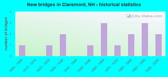
- New bridges - historical statistics
- 11900-1909
- 11920-1929
- 21930-1939
- 11950-1959
- 31960-1969
- 11970-1979
- 21980-1989
- 31990-1999
- 22000-2009

- Reconstructed bridges - Historical Statistics
- 11970-1979
- 31980-1989
- 01990-1999
- 12000-2009


- Bridge Condition - Deck
- 23.1%Very good
- 7.7%Good
- 15.4%Satisfactory
- 38.5%Fair
- 7.7%Poor
- 7.7%Serious

- Bridge Condition - Superstructure
- 23.1%Very good
- 38.5%Good
- 23.1%Satisfactory
- 15.4%Fair

- Bridge Condition - Substructure
- 7.7%Very good
- 53.8%Good
- 30.8%Satisfactory
- 7.7%Fair

- Bridge Condition - Channel
- 6.7%Very good
- 60.0%Good
- 13.3%Satisfactory
- 13.3%Fair
- 6.7%Poor

- Bridge Condition - Culverts
- 66.7%Good
- 33.3%Satisfactory
Find on map >> Show street view
Structure Number: 4200640009, Location: 1.0 MI NW JCT 12 AND 12A (Lat: 43.310500, Lng: -72.387778), Route carried "on" structure: Alternate State highway 12A, Year Built: 2002, Status: Open, Structure Length: 0.85m (2.79ft), Average Daily Traffic: 1,282 (year 2020), Truck Traffic: 16%, Average Future Daily Traffic: 1,897 (year 2042), Design Load: HS 25 or greater, Features Intersected: OX BROOK
Minimum Vertical Clearance: 30+ m (98+ ft), Kilometerpoint: 162.581, Lanes on structure: 2, Owner: State Highway Agency, Approaching Roadway Width: 9.1m (29.9ft), Skew: 1 degrees, Material/Design: Concrete, Design/Construction: Culvert, Number Of Spans In Main Unit: 1, Length of Maximum Span: 8.5m (27.9ft), Curb or Sidewalk Widths: Left: 0.1m (0.3ft), Right: 1.5m (4.9ft)
Condition: Channel: Very good, Culverts: Good, Operating Rating: 61.2 metric tons, Method Used To Determine Operating Rating: Load Factor (LF), Inventory Rating: 44.9 metric tons, Method Used To Determine Inventory Rating: Load Factor (LF), Structural Evaluation: Better than present minimum criteria, Waterway Adequacy: Better than present minimum criteria, Approach Roadway Alignment: Meets minimum limits, Length Of Structure Improvement: 0.85m (2.79ft), Designated Inspection Frequency: Every 24 months, Inspection Date: April 2020, Bridge Improvement Cost: $2,718,000, Roadway Improvement Cost: $200,000, Total Project Cost: $3,142,000 ( Estimate for 2022)
Find on map >> Show street view
Structure Number: 42006900096, Location: 2.2 MI. FROM CLAREMONT TL (Lat: 43.306325, Lng: -72.380561), Route carried "on" structure: State highway 12, Year Built: 1964, Status: Open, Structure Length: 0.82m (2.69ft), Average Daily Traffic: 7,058 (year 2020), Truck Traffic: 7%, Average Future Daily Traffic: 10,445 (year 2042), Design Load: H 20, Features Intersected: LITTLE SUGAR RIVER
Minimum Vertical Clearance: 30+ m (98+ ft), Kilometerpoint: 9.041, Lanes on structure: 2, Owner: State Highway Agency, Approaching Roadway Width: 13.4m (44.0ft), Skew: 1 degrees, Material/Design: Concrete, Design/Construction: Culvert, Number Of Spans In Main Unit: 1, Length of Maximum Span: 8.2m (26.9ft)
Condition: Channel: Good, Culverts: Satisfactory, Operating Rating: 89.8 metric tons, Method Used To Determine Operating Rating: Field evaluation and documented engineering judgment, Inventory Rating: 89.8 metric tons, Method Used To Determine Inventory Rating: Field evaluation and documented engineering judgment, Structural Evaluation: Equal to present minimum criteria, Waterway Adequacy: Equal to present desirable criteria, Approach Roadway Alignment: Equal to present desirable criteria, Length Of Structure Improvement: 0.82m (2.69ft), Designated Inspection Frequency: Every 24 months, Inspection Date: April 2020, Bridge Improvement Cost: $2,718,000, Roadway Improvement Cost: $200,000, Total Project Cost: $3,142,000 ( Estimate for 2022)
Find on map >> Show street view
Structure Number: 42007000092, Location: 0.6 MI NW JCT 12 AND 12A (Lat: 43.305764, Lng: -72.386400), Route carried "on" structure: State highway 12A, Year Built: 1984, Status: Open, Structure Length: 1.10m (3.61ft), Average Daily Traffic: 1,282 (year 2020), Truck Traffic: 4%, Average Future Daily Traffic: 1,897 (year 2042), Design Load: HS 20+Mod, Features Intersected: LITTLE SUGAR RIVER
Minimum Vertical Clearance: 30+ m (98+ ft), Kilometerpoint: 162.042, Lanes on structure: 2, Owner: State Highway Agency, Approaching Roadway Width: 6.1m (20.0ft), Material/Design: Steel, Design/Construction: Stringer/Multi-beam, Number Of Spans In Main Unit: 1, Length of Maximum Span: 9.8m (32.2ft), Curb or Sidewalk Widths: Left: 0.2m (0.7ft), Right: 0.2m (0.7ft), Curb-To-Curb Width: 8.6m (28.2ft), Out-to-Out Width: 9.6m (31.5ft)
Condition: Deck: Very good, Superstructure: Good, Substructure: Good, Channel: Good, Operating Rating: 65.0 metric tons, Method Used To Determine Operating Rating: Load Factor (LF), Inventory Rating: 39.0 metric tons, Method Used To Determine Inventory Rating: Load Factor (LF), Structural Evaluation: Better than present minimum criteria, Deck Geometry: Somewhat better than minimum adequacy, Waterway Adequacy: Equal to present desirable criteria, Approach Roadway Alignment: Meets minimum limits, Length Of Structure Improvement: 1.10m (3.61ft), Designated Inspection Frequency: Every 24 months, Underwater Inspection Frequency: Every 60 months, Inspection Date: April 2020, Underwater Inspection Date: August 2018, Bridge Improvement Cost: $2,718,000, Roadway Improvement Cost: $200,000, Total Project Cost: $3,142,000 ( Estimate for 2022), Deck Structure Type: Concrete Cast-file-Place, Wearing Surface/Protective System: Wearing Surface: Bituminous
Find on map >> Show street view
Structure Number: 42007600091, Location: 0.4 MI EAST ROUTE 12 (Lat: 43.301392, Lng: -72.387878), Route carried "on" structure: Alternate State highway 12A, Year Built: 2000, Status: Open, Structure Length: 3.32m (10.89ft), Average Daily Traffic: 1,282 (year 2020), Truck Traffic: 4%, Average Future Daily Traffic: 1,897 (year 2042), Design Load: HS 25 or greater, Features Intersected: NECRR
Minimum Vertical Clearance: 30+ m (98+ ft), Kilometerpoint: 161.504, Lanes on structure: 2, Owner: State Highway Agency, Approaching Roadway Width: 8.8m (28.9ft), Skew: 6 degrees, Material/Design: Steel, Design/Construction: Stringer/Multi-beam, Number Of Spans In Main Unit: 1, Length of Maximum Span: 32.0m (105.0ft), Curb or Sidewalk Widths: Left: 0.1m (0.3ft), Right: 0.1m (0.3ft), Curb-To-Curb Width: 9.0m (29.5ft), Out-to-Out Width: 10.1m (33.1ft)
Condition: Deck: Very good, Superstructure: Very good, Substructure: Very good, Operating Rating: 67.8 metric tons, Method Used To Determine Operating Rating: Load Factor (LF), Inventory Rating: 40.8 metric tons, Method Used To Determine Inventory Rating: Load Factor (LF), Structural Evaluation: Equal to present desirable criteria, Deck Geometry: Somewhat better than minimum adequacy, Underclear: Better than present minimum criteria, Approach Roadway Alignment: Meets minimum limits, Length Of Structure Improvement: 3.32m (10.89ft), Designated Inspection Frequency: Every 24 months, Inspection Date: April 2020, Bridge Improvement Cost: $2,718,000, Roadway Improvement Cost: $200,000, Total Project Cost: $3,142,000 ( Estimate for 2022), Deck Structure Type: Concrete Precast Panels, Wearing Surface/Protective System: Wearing Surface: Bituminous, Membrane: Other, Deck Protection: Epoxy Coated Reinforcing
Find on map >> Show street view
Structure Number: 47006500134, Location: NH VT SL (Lat: 43.402989, Lng: -72.400092), Route carried "on" structure: State highway 12, Year Built: 1969, Status: Open, Structure Length: 20.67m (67.81ft), Average Daily Traffic: 8,468 (year 2020), Truck Traffic: 7%, Average Future Daily Traffic: 12,532 (year 2042), Design Load: HS 20, Features Intersected: CONNECTICUT RIVER
Minimum Vertical Clearance: 30+ m (98+ ft), Kilometerpoint: 100.922, Lanes on structure: 2, Base Highway Network: Yes, Owner: State Highway Agency, Approaching Roadway Width: 13.4m (44.0ft), Material/Design: Steel continuous, Design/Construction: Stringer/Multi-beam, Number Of Spans In Main Unit: 4, Length of Maximum Span: 54.9m (180.1ft), Curb or Sidewalk Widths: Left: 0.2m (0.7ft), Right: 0.2m (0.7ft), Curb-To-Curb Width: 13.4m (44.0ft), Out-to-Out Width: 14.7m (48.2ft)
Condition: Deck: Fair, Superstructure: Good, Substructure: Good, Channel: Satisfactory, Operating Rating: 53.4 metric tons, Method Used To Determine Operating Rating: Load Factor (LF), Inventory Rating: 32.0 metric tons, Method Used To Determine Inventory Rating: Load Factor (LF), Structural Evaluation: Better than present minimum criteria, Deck Geometry: Equal to present minimum criteria, Waterway Adequacy: Superior to present desirable criteria, Approach Roadway Alignment: Equal to present desirable criteria, Length Of Structure Improvement: 20.67m (67.81ft), Designated Inspection Frequency: Every 24 months, Underwater Inspection Frequency: Every 60 months, Inspection Date: May 2021, Underwater Inspection Date: August 2017, Bridge Improvement Cost: $2,718,000, Roadway Improvement Cost: $200,000, Total Project Cost: $3,142,000 ( Estimate for 2022), Deck Structure Type: Concrete Cast-file-Place, Wearing Surface/Protective System: Wearing Surface: Bituminous, Membrane: Other
Find on map >> Show street view
Structure Number: 47007200127, Location: .1 MI. FROM JCT. RTE. 103 (Lat: 43.398264, Lng: -72.393589), Route carried "on" structure: State highway 12A, Year Built: 1967, Year Reconstructed: 1991, Status: Open, Structure Length: 8.56m (28.08ft), Average Daily Traffic: 930 (year 2020), Truck Traffic: 7%, Average Future Daily Traffic: 1,376 (year 2042), Design Load: HS 20, Features Intersected: SUGAR RIVER
Minimum Vertical Clearance: 30+ m (98+ ft), Kilometerpoint: 172.926, Lanes on structure: 2, Owner: State Highway Agency, Approaching Roadway Width: 7.9m (25.9ft), Skew: 1 degrees, Material/Design: Steel continuous, Design/Construction: Stringer/Multi-beam, Number Of Spans In Main Unit: 3, Length of Maximum Span: 34.1m (111.9ft), Curb or Sidewalk Widths: Left: 0.3m (1.0ft), Right: 0.3m (1.0ft), Curb-To-Curb Width: 8.5m (27.9ft), Out-to-Out Width: 10.0m (32.8ft)
Condition: Deck: Serious, Superstructure: Satisfactory, Substructure: Satisfactory, Channel: Good, Operating Rating: 25.1 metric tons, Method Used To Determine Operating Rating: Load Factor (LF), Inventory Rating: 15.1 metric tons, Method Used To Determine Inventory Rating: Load Factor (LF), Structural Evaluation: Meets minimum limits, Deck Geometry: Somewhat better than minimum adequacy, Waterway Adequacy: Superior to present desirable criteria, Approach Roadway Alignment: Equal to present desirable criteria, Length Of Structure Improvement: 8.56m (28.08ft), Designated Inspection Frequency: Every 8 months, Inspection Date: November 2021, Bridge Improvement Cost: $2,718,000, Roadway Improvement Cost: $200,000, Total Project Cost: $3,142,000 ( Estimate for 2022), Deck Structure Type: Concrete Cast-file-Place, Wearing Surface/Protective System: Wearing Surface: Latex Concrete
Find on map >> Show street view
Structure Number: 47009100118, Location: 0.1 MI JCT RTE 12 (Lat: 43.390586, Lng: -72.376172), Route carried "on" structure: City street , Year Built: 1974, Status: Open, Structure Length: 5.91m (19.39ft), Average Daily Traffic: 1,263 (year 2020), Truck Traffic: 3%, Average Future Daily Traffic: 1,869 (year 2042), Design Load: HS 20, Features Intersected: SUGAR RIVER, Facility Carried by Structure: PLAINS ROAD
Minimum Vertical Clearance: 30+ m (98+ ft), Kilometerpoint: 2.597, Lanes on structure: 2, Owner: City or Municipal Highway Agency, Approaching Roadway Width: 6.4m (21.0ft), Material/Design: Steel continuous, Design/Construction: Stringer/Multi-beam, Number Of Spans In Main Unit: 2, Length of Maximum Span: 29.0m (95.1ft), Curb or Sidewalk Widths: Left: 1.5m (4.9ft), Right: 0.2m (0.7ft), Curb-To-Curb Width: 8.5m (27.9ft), Out-to-Out Width: 11.1m (36.4ft)
Condition: Deck: Poor, Superstructure: Satisfactory, Substructure: Good, Channel: Good, Operating Rating: 44.7 metric tons, Method Used To Determine Operating Rating: Field evaluation and documented engineering judgment, Inventory Rating: 32.7 metric tons, Method Used To Determine Inventory Rating: Field evaluation and documented engineering judgment, Structural Evaluation: Equal to present minimum criteria, Deck Geometry: Somewhat better than minimum adequacy, Waterway Adequacy: Superior to present desirable criteria, Approach Roadway Alignment: Equal to present desirable criteria, Length Of Structure Improvement: 5.91m (19.39ft), Designated Inspection Frequency: Every 16 months, Inspection Date: September 2021, Bridge Improvement Cost: $2,718,000, Roadway Improvement Cost: $200,000, Total Project Cost: $3,142,000 ( Estimate for 2022), Deck Structure Type: Concrete Cast-file-Place, Wearing Surface/Protective System: Wearing Surface: Monolithic Concrete
Find on map >> Show street view
Structure Number: 4701060012, Location: 2.3 MI FROM VT. SL (Lat: 43.390889, Lng: -72.360986), Route carried "on" structure: State highway 12, Year Built: 1997, Status: Open, Structure Length: 1.28m (4.20ft), Average Daily Traffic: 8,682 (year 2020), Truck Traffic: 5%, Average Future Daily Traffic: 12,849 (year 2042), Design Load: HS 25 or greater, Features Intersected: RED WATER BROOK
Minimum Vertical Clearance: 30+ m (98+ ft), Kilometerpoint: 97.214, Lanes on structure: 2, Base Highway Network: Yes, Owner: State Highway Agency, Approaching Roadway Width: 13.4m (44.0ft), Material/Design: Prestressed concrete, Design/Construction: Slab, Number Of Spans In Main Unit: 1, Length of Maximum Span: 11.6m (38.1ft), Curb or Sidewalk Widths: Left: 1.5m (4.9ft), Right: 0.2m (0.7ft), Curb-To-Curb Width: 13.3m (43.6ft), Out-to-Out Width: 15.7m (51.5ft)
Condition: Deck: Good, Superstructure: Good, Substructure: Good, Channel: Satisfactory, Operating Rating: 89.4 metric tons, Method Used To Determine Operating Rating: Load Factor (LF), Inventory Rating: 53.5 metric tons, Method Used To Determine Inventory Rating: Load Factor (LF), Structural Evaluation: Better than present minimum criteria, Deck Geometry: Somewhat better than minimum adequacy, Waterway Adequacy: Superior to present desirable criteria, Approach Roadway Alignment: Equal to present desirable criteria, Length Of Structure Improvement: 1.28m (4.20ft), Designated Inspection Frequency: Every 24 months, Inspection Date: June 2021, Bridge Improvement Cost: $2,718,000, Roadway Improvement Cost: $200,000, Total Project Cost: $3,142,000 ( Estimate for 2022), Deck Structure Type: Concrete Precast Panels, Wearing Surface/Protective System: Wearing Surface: Bituminous, Membrane: Preformed Fabric, Deck Protection: Epoxy Coated Reinforcing
Find on map >> Show street view
Structure Number: 47010600128, Location: 1.4MI NH12 (Lat: 43.396758, Lng: -72.359794), Route carried "on" structure: City street , Year Built: 1900, Year Reconstructed: 2008, Status: Open, Structure Length: 0.83m (2.72ft), Average Daily Traffic: 505 (year 2020), Truck Traffic: 4%, Average Future Daily Traffic: 747 (year 2042), Design Load: HL 93, Features Intersected: RED WATER BROOK, Facility Carried by Structure: THRASHER ROAD
Minimum Vertical Clearance: 30+ m (98+ ft), Kilometerpoint: 0.229, Lanes on structure: 2, Owner: City or Municipal Highway Agency, Approaching Roadway Width: 5.8m (19.0ft), Skew: 1 degrees, Material/Design: Concrete, Design/Construction: Slab, Number Of Spans In Main Unit: 1, Length of Maximum Span: 7.1m (23.3ft), Curb-To-Curb Width: 5.8m (19.0ft), Out-to-Out Width: 6.5m (21.3ft)
Condition: Deck: Very good, Superstructure: Very good, Substructure: Good, Channel: Fair, Operating Rating: 73.0 metric tons, Method Used To Determine Operating Rating: Load and Resistance Factor (LRFR), Inventory Rating: 56.7 metric tons, Method Used To Determine Inventory Rating: Load and Resistance Factor (LRFR), Structural Evaluation: Better than present minimum criteria, Deck Geometry: High priority of replacement, Waterway Adequacy: Better than present minimum criteria, Approach Roadway Alignment: Equal to present minimum criteria, Length Of Structure Improvement: 0.83m (2.72ft), Designated Inspection Frequency: Every 24 months, Inspection Date: September 2021, Bridge Improvement Cost: $2,718,000, Roadway Improvement Cost: $200,000, Total Project Cost: $3,142,000 ( Estimate for 2022), Deck Structure Type: Concrete Cast-file-Place, Wearing Surface/Protective System: Wearing Surface: Monolithic Concrete
Find on map >> Show street view
Structure Number: 47010800136, Location: 0.9MI NH11 (Lat: 43.402617, Lng: -72.358697), Route carried "on" structure: City street , Year Built: 1925, Year Reconstructed: 1981, Status: Open, Structure Length: 0.76m (2.49ft), Average Daily Traffic: 277 (year 2020), Truck Traffic: 4%, Average Future Daily Traffic: 409 (year 2042), Features Intersected: RED WATER BROOK, Facility Carried by Structure: RED WATER BROOK RD
Minimum Vertical Clearance: 30+ m (98+ ft), Kilometerpoint: 1.353, Lanes on structure: 2, Owner: City or Municipal Highway Agency, Approaching Roadway Width: 6.1m (20.0ft), Material/Design: Steel, Design/Construction: Stringer/Multi-beam, Number Of Spans In Main Unit: 1, Length of Maximum Span: 6.4m (21.0ft), Curb-To-Curb Width: 7.2m (23.6ft), Out-to-Out Width: 7.3m (24.0ft)
Condition: Deck: Fair, Superstructure: Fair, Substructure: Satisfactory, Channel: Good, Operating Rating: 31.2 metric tons, Method Used To Determine Operating Rating: Allowable Stress (AS), Inventory Rating: 22.9 metric tons, Method Used To Determine Inventory Rating: Allowable Stress (AS), Structural Evaluation: Somewhat better than minimum adequacy, Deck Geometry: Meets minimum limits, Waterway Adequacy: Superior to present desirable criteria, Approach Roadway Alignment: Equal to present minimum criteria, Length Of Structure Improvement: 0.76m (2.49ft), Designated Inspection Frequency: Every 24 months, Inspection Date: September 2021, Bridge Improvement Cost: $2,718,000, Roadway Improvement Cost: $200,000, Total Project Cost: $3,142,000 ( Estimate for 2022), Deck Structure Type: Corrugated Steel, Wearing Surface/Protective System: Wearing Surface: Bituminous
Find on map >> Show street view
Structure Number: 47011300113, Location: 100 FT JCT RTE 12 (Lat: 43.384167, Lng: -72.353581), Route carried "on" structure: City street , Year Built: 1959, Status: Open, Structure Length: 4.39m (14.40ft), Average Daily Traffic: 1,351 (year 2020), Truck Traffic: 3%, Average Future Daily Traffic: 1,999 (year 2042), Design Load: HS 15, Features Intersected: SUGAR RIVER, Facility Carried by Structure: CITIZENS STREET
Minimum Vertical Clearance: 30+ m (98+ ft), Kilometerpoint: 0.336, Lanes on structure: 2, Owner: City or Municipal Highway Agency, Approaching Roadway Width: 7.3m (24.0ft), Material/Design: Steel continuous, Design/Construction: Stringer/Multi-beam, Number Of Spans In Main Unit: 2, Length of Maximum Span: 21.3m (69.9ft), Curb or Sidewalk Widths: Left: 0.3m (1.0ft), Right: 1.2m (3.9ft), Curb-To-Curb Width: 7.3m (24.0ft), Out-to-Out Width: 9.4m (30.8ft)
Condition: Deck: Fair, Superstructure: Good, Substructure: Satisfactory, Channel: Poor, Operating Rating: 33.7 metric tons, Method Used To Determine Operating Rating: Field evaluation and documented engineering judgment, Inventory Rating: 24.5 metric tons, Method Used To Determine Inventory Rating: Field evaluation and documented engineering judgment, Structural Evaluation: Equal to present minimum criteria, Deck Geometry: Meets minimum limits, Waterway Adequacy: Equal to present minimum criteria, Approach Roadway Alignment: Meets minimum limits, Length Of Structure Improvement: 4.39m (14.40ft), Designated Inspection Frequency: Every 24 months, Inspection Date: September 2021, Bridge Improvement Cost: $2,718,000, Roadway Improvement Cost: $200,000, Total Project Cost: $3,142,000 ( Estimate for 2022), Deck Structure Type: Concrete Cast-file-Place, Wearing Surface/Protective System: Wearing Surface: Bituminous
Find on map >> Show street view
Structure Number: 47012200098, Location: 3.8 MI FROM VERMONT SL (Lat: 43.375525, Lng: -72.345786), Route carried "on" structure: State highway 12, Year Built: 1996, Status: Open, Structure Length: 3.72m (12.20ft), Average Daily Traffic: 5,367 (year 2020), Truck Traffic: 3%, Average Future Daily Traffic: 7,943 (year 2042), Design Load: HS 25 or greater, Features Intersected: SUGAR RIVER
Minimum Vertical Clearance: 30+ m (98+ ft), Kilometerpoint: 94.777, Lanes on structure: 2, Base Highway Network: Yes, Owner: City or Municipal Highway Agency, Approaching Roadway Width: 9.8m (32.2ft), Skew: 1 degrees, Material/Design: Steel, Design/Construction: Stringer/Multi-beam, Number Of Spans In Main Unit: 1, Length of Maximum Span: 36.0m (118.1ft), Curb or Sidewalk Widths: Left: 1.5m (4.9ft), Right: 1.5m (4.9ft), Curb-To-Curb Width: 9.8m (32.2ft), Out-to-Out Width: 13.6m (44.6ft)
Condition: Deck: Satisfactory, Superstructure: Very good, Substructure: Satisfactory, Channel: Good, Operating Rating: 67.8 metric tons, Method Used To Determine Operating Rating: Load Factor (LF), Inventory Rating: 40.8 metric tons, Method Used To Determine Inventory Rating: Load Factor (LF), Structural Evaluation: Equal to present minimum criteria, Deck Geometry: Meets minimum limits, Waterway Adequacy: Superior to present desirable criteria, Approach Roadway Alignment: Equal to present desirable criteria, Length Of Structure Improvement: 3.72m (12.20ft), Designated Inspection Frequency: Every 24 months, Inspection Date: September 2021, Bridge Improvement Cost: $2,718,000, Roadway Improvement Cost: $200,000, Total Project Cost: $3,142,000 ( Estimate for 2022), Deck Structure Type: Concrete Cast-file-Place, Wearing Surface/Protective System: Wearing Surface: Bituminous, Membrane: Preformed Fabric, Deck Protection: Epoxy Coated Reinforcing
Find on map >> Show street view
Structure Number: 47012400164, Location: TOWN RD (Lat: 43.422569, Lng: -72.343175), Route carried "on" structure: City street , Year Built: 1991, Status: Open, Structure Length: 0.73m (2.40ft), Average Daily Traffic: 81 (year 2020), Average Future Daily Traffic: 119 (year 2042), Features Intersected: RED WATER BROOK, Facility Carried by Structure: STRAND ROAD
Minimum Vertical Clearance: 30+ m (98+ ft), Kilometerpoint: 0.142, Lanes on structure: 2, Owner: City or Municipal Highway Agency, Approaching Roadway Width: 3.7m (12.1ft), Material/Design: Concrete, Design/Construction: Culvert, Number Of Spans In Main Unit: 1, Length of Maximum Span: 7.3m (24.0ft)
Condition: Channel: Good, Culverts: Good, Operating Rating: 54.5 metric tons, Method Used To Determine Operating Rating: Field evaluation and documented engineering judgment, Inventory Rating: 32.7 metric tons, Method Used To Determine Inventory Rating: Field evaluation and documented engineering judgment, Structural Evaluation: Better than present minimum criteria, Waterway Adequacy: Superior to present desirable criteria, Approach Roadway Alignment: Equal to present desirable criteria, Length Of Structure Improvement: 0.73m (2.40ft), Designated Inspection Frequency: Every 24 months, Inspection Date: September 2021, Bridge Improvement Cost: $2,718,000, Roadway Improvement Cost: $200,000, Total Project Cost: $3,142,000 ( Estimate for 2022)
Find on map >> Show street view
Structure Number: 47013200097, Location: 4.4 MI FROM VERMONT SL (Lat: 43.373733, Lng: -72.336428), Route carried "on" structure: State highway 11, Year Built: 1981, Status: Open, Structure Length: 4.05m (13.29ft), Average Daily Traffic: 15,627 (year 2020), Truck Traffic: 5%, Average Future Daily Traffic: 23,127 (year 2042), Design Load: HS 25 or greater, Features Intersected: SUGAR RIVER
Minimum Vertical Clearance: 30+ m (98+ ft), Kilometerpoint: 17.722, Lanes on structure: 4, Base Highway Network: Yes, Owner: City or Municipal Highway Agency, Approaching Roadway Width: 17.1m (56.1ft), Skew: 32 degrees, Material/Design: Steel, Design/Construction: Stringer/Multi-beam, Number Of Spans In Main Unit: 1, Length of Maximum Span: 39.0m (128.0ft), Curb or Sidewalk Widths: Left: 1.8m (5.9ft), Right: 1.8m (5.9ft), Curb-To-Curb Width: 17.1m (56.1ft), Out-to-Out Width: 23.3m (76.4ft)
Condition: Deck: Fair, Superstructure: Good, Substructure: Good, Channel: Good, Operating Rating: 53.4 metric tons, Method Used To Determine Operating Rating: Load Factor (LF), Inventory Rating: 32.0 metric tons, Method Used To Determine Inventory Rating: Load Factor (LF), Structural Evaluation: Better than present minimum criteria, Deck Geometry: Somewhat better than minimum adequacy, Waterway Adequacy: Superior to present desirable criteria, Approach Roadway Alignment: Equal to present desirable criteria, Length Of Structure Improvement: 4.05m (13.29ft), Designated Inspection Frequency: Every 24 months, Inspection Date: September 2021, Bridge Improvement Cost: $2,718,000, Roadway Improvement Cost: $200,000, Total Project Cost: $3,142,000 ( Estimate for 2022), Deck Structure Type: Concrete Cast-file-Place, Wearing Surface/Protective System: Wearing Surface: Bituminous, Membrane: Other
Find on map >> Show street view
Structure Number: 47013400167, Location: 0.3 MI NH 120 (Lat: 43.424303, Lng: -72.330461), Route carried "on" structure: City street , Year Built: 1935, Year Reconstructed: 1985, Status: Open, Structure Length: 0.98m (3.22ft), Average Daily Traffic: 81 (year 2020), Truck Traffic: 4%, Average Future Daily Traffic: 119 (year 2042), Design Load: H 20, Features Intersected: RED WATER BROOK, Facility Carried by Structure: RED WATER BROOK RD
Minimum Vertical Clearance: 30+ m (98+ ft), Kilometerpoint: 1.804, Lanes on structure: 2, Owner: City or Municipal Highway Agency, Approaching Roadway Width: 4.9m (16.1ft), Skew: 5 degrees, Material/Design: Prestressed concrete, Design/Construction: Tee Beam, Number Of Spans In Main Unit: 1, Length of Maximum Span: 8.8m (28.9ft), Curb-To-Curb Width: 5.9m (19.4ft), Out-to-Out Width: 6.1m (20.0ft)
Condition: Deck: Satisfactory, Superstructure: Satisfactory, Substructure: Fair, Channel: Fair, Operating Rating: 54.5 metric tons, Method Used To Determine Operating Rating: Field evaluation and documented engineering judgment, Inventory Rating: 32.7 metric tons, Method Used To Determine Inventory Rating: Field evaluation and documented engineering judgment, Structural Evaluation: Somewhat better than minimum adequacy, Deck Geometry: Meets minimum limits, Waterway Adequacy: Equal to present desirable criteria, Approach Roadway Alignment: Equal to present desirable criteria, Length Of Structure Improvement: 0.98m (3.22ft), Designated Inspection Frequency: Every 24 months, Inspection Date: September 2021, Bridge Improvement Cost: $2,718,000, Roadway Improvement Cost: $200,000, Total Project Cost: $3,142,000 ( Estimate for 2022), Deck Structure Type: Concrete Precast Panels, Wearing Surface/Protective System: Wearing Surface: Bituminous, Membrane: Other
Find on map >> Show street view
Structure Number: 47015000164, Location: 0.3 MI CORNISH TL (Lat: 43.422069, Lng: -72.315886), Route carried "on" structure: City street , Year Built: 1930, Year Reconstructed: 1985, Status: Open, Structure Length: 1.01m (3.31ft), Average Daily Traffic: 81 (year 2020), Truck Traffic: 4%, Average Future Daily Traffic: 119 (year 2042), Features Intersected: RED WATER BROOK, Facility Carried by Structure: WHITEWATER BK RD
Minimum Vertical Clearance: 30+ m (98+ ft), Kilometerpoint: 0.571, Lanes on structure: 1, Owner: City or Municipal Highway Agency, Approaching Roadway Width: 4.6m (15.1ft), Skew: 4 degrees, Material/Design: Prestressed concrete, Design/Construction: Tee Beam, Number Of Spans In Main Unit: 1, Length of Maximum Span: 8.8m (28.9ft), Curb-To-Curb Width: 4.7m (15.4ft), Out-to-Out Width: 4.9m (16.1ft)
Condition: Deck: Fair, Superstructure: Fair, Substructure: Good, Channel: Good, Operating Rating: 54.5 metric tons, Method Used To Determine Operating Rating: Field evaluation and documented engineering judgment, Inventory Rating: 32.7 metric tons, Method Used To Determine Inventory Rating: Field evaluation and documented engineering judgment, Structural Evaluation: Somewhat better than minimum adequacy, Deck Geometry: Better than present minimum criteria, Waterway Adequacy: Better than present minimum criteria, Approach Roadway Alignment: Equal to present minimum criteria, Length Of Structure Improvement: 1.01m (3.31ft), Designated Inspection Frequency: Every 24 months, Inspection Date: September 2021, Bridge Improvement Cost: $2,718,000, Roadway Improvement Cost: $200,000, Total Project Cost: $3,142,000 ( Estimate for 2022), Deck Structure Type: Concrete Precast Panels, Wearing Surface/Protective System: Wearing Surface: Monolithic Concrete