Bridge Statistics for Citrus Park, Florida (FL)
Condition, Traffic, Stress, Structural Evaluation, Project Costs
- National Bridge Inventory (NBI) Statistics
- 28Number of bridges
- 312ft / 94.7mTotal length
- 561,223Total average daily traffic
- 55,443Total average daily truck traffic
- National Bridge Inventory (NBI) Registered Bridges for Citrus Park
- No street view available for this location
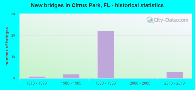
- New bridges - historical statistics
- 11970-1979
- 21980-1989
- 221990-1999
- 32010-2019


- Bridge Condition - Deck
- 5.6%Very good
- 94.4%Good

- Bridge Condition - Superstructure
- 22.2%Very good
- 77.8%Good

- Bridge Condition - Substructure
- 22.2%Very good
- 66.7%Good
- 11.1%Satisfactory

- Bridge Condition - Channel
- 23.1%Good
- 46.2%Satisfactory
- 30.8%Fair
Find on map >> Show street view
Structure Number: 10054, Location: 0.6 MI S OF WILSKY BLVD (Lat: 28.040425, Lng: -82.558989), Route carried "on" structure: State highway 589, Year Built: 1994, Year Reconstructed: 2016, Status: Open, Structure Length: 8.89m (29.17ft), Average Daily Traffic: 31,650 (year 2020), Truck Traffic: 10%, Average Future Daily Traffic: 54,913 (year 2042), Design Load: HL 93, Features Intersected: LINEBAUGH AVE
Minimum Vertical Clearance: 30+ m (98+ ft), Kilometerpoint: 9.130, Lanes on structure: 4, Lanes under structure: 5, Base Highway Network: Yes, Toll: On toll road, Owner: State Toll Authority, Approaching Roadway Width: 23.1m (75.8ft), Skew: 3 degrees, Material/Design: Prestressed concrete, Design/Construction: Stringer/Multi-beam, Number Of Spans In Main Unit: 4, Length of Maximum Span: 34.0m (111.5ft), Curb-To-Curb Width: 23.1m (75.8ft), Out-to-Out Width: 23.3m (76.4ft)
Condition: Deck: Good, Superstructure: Good, Substructure: Very good, Operating Rating: 50.6 metric tons, Method Used To Determine Operating Rating: Load and Resistance Factor (LRFR), Inventory Rating: 46.1 metric tons, Method Used To Determine Inventory Rating: Load and Resistance Factor (LRFR), Structural Evaluation: Better than present minimum criteria, Deck Geometry: Superior to present desirable criteria, Underclear: High priority of corrective action, Approach Roadway Alignment: Equal to present desirable criteria, Designated Inspection Frequency: Every 24 months, Inspection Date: Febuary 2022, Deck Structure Type: Concrete Cast-file-Place
Find on map >> Show street view
Structure Number: 100541, Location: 0.6 MI S OF WILSKY BLVD (Lat: 28.040439, Lng: -82.558717), Route carried "on" structure: State highway 589, Year Built: 1994, Year Reconstructed: 2016, Status: Open, Structure Length: 8.93m (29.30ft), Average Daily Traffic: 31,650 (year 2020), Truck Traffic: 10%, Average Future Daily Traffic: 54,913 (year 2042), Design Load: HL 93, Features Intersected: LINEBAUGH AVE
Minimum Vertical Clearance: 30+ m (98+ ft), Kilometerpoint: 9.110, Lanes on structure: 5, Lanes under structure: 5, Base Highway Network: Yes, Toll: On toll road, Owner: State Toll Authority, Approaching Roadway Width: 24.4m (80.1ft), Skew: 5 degrees, Material/Design: Prestressed concrete, Design/Construction: Stringer/Multi-beam, Number Of Spans In Main Unit: 4, Length of Maximum Span: 34.0m (111.5ft), Curb-To-Curb Width: 24.4m (80.1ft), Out-to-Out Width: 25.3m (83.0ft)
Condition: Deck: Good, Superstructure: Good, Substructure: Good, Operating Rating: 42.5 metric tons, Method Used To Determine Operating Rating: Load and Resistance Factor (LRFR), Inventory Rating: 39.2 metric tons, Method Used To Determine Inventory Rating: Load and Resistance Factor (LRFR), Structural Evaluation: Better than present minimum criteria, Deck Geometry: Equal to present minimum criteria, Underclear: High priority of corrective action, Approach Roadway Alignment: Equal to present desirable criteria, Designated Inspection Frequency: Every 24 months, Inspection Date: Febuary 2022, Deck Structure Type: Concrete Cast-file-Place
Find on map >> Show street view
Structure Number: 100544, Location: 1.4MI S OF GUNN HWY (Lat: 28.047383, Lng: -82.568358), Route carried "on" structure: State highway 589, Year Built: 1994, Year Reconstructed: 2016, Status: Open, Structure Length: 10.92m (35.83ft), Average Daily Traffic: 32,700 (year 2020), Truck Traffic: 10%, Average Future Daily Traffic: 56,734 (year 2042), Design Load: HL 93, Features Intersected: ROCKY CREEK I
Minimum Vertical Clearance: 30+ m (98+ ft), Kilometerpoint: 10.350, Lanes on structure: 4, Base Highway Network: Yes, Toll: On toll road, Owner: State Toll Authority, Approaching Roadway Width: 22.4m (73.5ft), Material/Design: Prestressed concrete, Design/Construction: Stringer/Multi-beam, Number Of Spans In Main Unit: 5, Length of Maximum Span: 21.8m (71.5ft), Curb-To-Curb Width: 22.4m (73.5ft), Out-to-Out Width: 23.3m (76.4ft)
Condition: Deck: Good, Superstructure: Good, Substructure: Good, Channel: Fair, Operating Rating: 44.7 metric tons, Method Used To Determine Operating Rating: Load and Resistance Factor (LRFR), Inventory Rating: 35.3 metric tons, Method Used To Determine Inventory Rating: Load and Resistance Factor (LRFR), Structural Evaluation: Better than present minimum criteria, Deck Geometry: Superior to present desirable criteria, Waterway Adequacy: Superior to present desirable criteria, Approach Roadway Alignment: Equal to present desirable criteria, Designated Inspection Frequency: Every 24 months, Inspection Date: Febuary 2022, Deck Structure Type: Concrete Cast-file-Place
Find on map >> Show street view
Structure Number: 100545, Location: 1.4MI S OF GUNN HWY (Lat: 28.047581, Lng: -82.568194), Route carried "on" structure: State highway 589, Year Built: 1994, Year Reconstructed: 2016, Status: Open, Structure Length: 10.40m (34.12ft), Average Daily Traffic: 32,700 (year 2020), Truck Traffic: 10%, Average Future Daily Traffic: 56,734 (year 2042), Design Load: HL 93, Features Intersected: ROCKY CREEK I
Minimum Vertical Clearance: 30+ m (98+ ft), Kilometerpoint: 10.350, Lanes on structure: 5, Base Highway Network: Yes, Toll: On toll road, Owner: State Toll Authority, Approaching Roadway Width: 24.5m (80.4ft), Material/Design: Prestressed concrete, Design/Construction: Stringer/Multi-beam, Number Of Spans In Main Unit: 5, Length of Maximum Span: 20.9m (68.6ft), Curb-To-Curb Width: 24.5m (80.4ft), Out-to-Out Width: 25.4m (83.3ft)
Condition: Deck: Good, Superstructure: Good, Substructure: Good, Channel: Fair, Operating Rating: 52.3 metric tons, Method Used To Determine Operating Rating: Load and Resistance Factor (LRFR), Inventory Rating: 40.2 metric tons, Method Used To Determine Inventory Rating: Load and Resistance Factor (LRFR), Structural Evaluation: Better than present minimum criteria, Deck Geometry: Equal to present minimum criteria, Waterway Adequacy: Superior to present desirable criteria, Approach Roadway Alignment: Equal to present desirable criteria, Designated Inspection Frequency: Every 24 months, Inspection Date: Febuary 2022, Deck Structure Type: Concrete Cast-file-Place
Find on map >> Show street view
Structure Number: 100546, Location: 1 MILE S OF GUNN HWY (Lat: 28.051444, Lng: -82.569853), Route carried "on" structure: State highway 589, Year Built: 1994, Year Reconstructed: 2016, Status: Open, Structure Length: 4.19m (13.75ft), Average Daily Traffic: 32,700 (year 2020), Truck Traffic: 10%, Average Future Daily Traffic: 56,734 (year 2042), Design Load: HL 93, Features Intersected: GARDNER RD
Minimum Vertical Clearance: 30+ m (98+ ft), Kilometerpoint: 10.844, Lanes on structure: 4, Lanes under structure: 2, Base Highway Network: Yes, Toll: On toll road, Owner: State Toll Authority, Approaching Roadway Width: 22.4m (73.5ft), Material/Design: Prestressed concrete, Design/Construction: Stringer/Multi-beam, Number Of Spans In Main Unit: 3, Length of Maximum Span: 23.0m (75.5ft), Curb-To-Curb Width: 22.4m (73.5ft), Out-to-Out Width: 23.3m (76.4ft)
Condition: Deck: Good, Superstructure: Good, Substructure: Very good, Operating Rating: 39.8 metric tons, Method Used To Determine Operating Rating: Load and Resistance Factor (LRFR), Inventory Rating: 33.3 metric tons, Method Used To Determine Inventory Rating: Load and Resistance Factor (LRFR), Structural Evaluation: Better than present minimum criteria, Deck Geometry: Superior to present desirable criteria, Underclear: Superior to present desirable criteria, Approach Roadway Alignment: Equal to present desirable criteria, Designated Inspection Frequency: Every 24 months, Inspection Date: Febuary 2022, Deck Structure Type: Concrete Cast-file-Place
Find on map >> Show street view
Structure Number: 100547, Location: 1 MILE S OF GUNN HWY (Lat: 28.051444, Lng: -82.569631), Route carried "on" structure: State highway 589, Year Built: 1994, Year Reconstructed: 2016, Status: Open, Structure Length: 4.19m (13.75ft), Average Daily Traffic: 32,700 (year 2020), Truck Traffic: 10%, Average Future Daily Traffic: 56,734 (year 2042), Design Load: HL 93, Features Intersected: GARDNER RD
Minimum Vertical Clearance: 30+ m (98+ ft), Kilometerpoint: 10.844, Lanes on structure: 4, Lanes under structure: 2, Base Highway Network: Yes, Toll: On toll road, Owner: State Toll Authority, Approaching Roadway Width: 20.7m (67.9ft), Material/Design: Prestressed concrete, Design/Construction: Stringer/Multi-beam, Number Of Spans In Main Unit: 3, Length of Maximum Span: 23.0m (75.5ft), Curb-To-Curb Width: 20.7m (67.9ft), Out-to-Out Width: 21.6m (70.9ft)
Condition: Deck: Good, Superstructure: Good, Substructure: Very good, Operating Rating: 39.2 metric tons, Method Used To Determine Operating Rating: Load and Resistance Factor (LRFR), Inventory Rating: 33.0 metric tons, Method Used To Determine Inventory Rating: Load and Resistance Factor (LRFR), Structural Evaluation: Better than present minimum criteria, Deck Geometry: Equal to present minimum criteria, Underclear: Better than present minimum criteria, Approach Roadway Alignment: Equal to present desirable criteria, Designated Inspection Frequency: Every 24 months, Inspection Date: Febuary 2022, Deck Structure Type: Concrete Cast-file-Place
Find on map >> Show street view
Structure Number: 100548, Location: 0.9 MI S OF EHRLICH ROAD (Lat: 28.065936, Lng: -82.567556), Route carried "on" structure: State highway 589, Year Built: 1994, Year Reconstructed: 2017, Status: Open, Structure Length: 8.12m (26.64ft), Average Daily Traffic: 32,700 (year 2020), Truck Traffic: 10%, Average Future Daily Traffic: 56,734 (year 2042), Design Load: HL 93, Features Intersected: CR 587 GUNN HWY
Minimum Vertical Clearance: 30+ m (98+ ft), Kilometerpoint: 12.460, Lanes on structure: 4, Lanes under structure: 6, Base Highway Network: Yes, Toll: On toll road, Owner: State Toll Authority, Approaching Roadway Width: 21.7m (71.2ft), Skew: 2 degrees, Material/Design: Steel, Design/Construction: Stringer/Multi-beam, Number Of Spans In Main Unit: 1, Length of Maximum Span: 81.2m (266.4ft), Curb-To-Curb Width: 21.0m (68.9ft), Out-to-Out Width: 21.9m (71.9ft)
Condition: Deck: Good, Superstructure: Very good, Substructure: Good, Inventory Rating: 74.5 metric tons, Method Used To Determine Inventory Rating: Load and Resistance Factor (LRFR), Structural Evaluation: Better than present minimum criteria, Deck Geometry: Better than present minimum criteria, Underclear: Superior to present desirable criteria, Approach Roadway Alignment: Equal to present desirable criteria, Designated Inspection Frequency: Every 24 months, Inspection Date: March 2020, Deck Structure Type: Concrete Cast-file-Place
Find on map >> Show street view
Structure Number: 100549, Location: 0.9 MI S OF EHRLICH ROAD (Lat: 28.065911, Lng: -82.567306), Route carried "on" structure: State highway 589, Year Built: 1994, Year Reconstructed: 2017, Status: Open, Structure Length: 8.12m (26.64ft), Average Daily Traffic: 32,700 (year 2020), Truck Traffic: 10%, Average Future Daily Traffic: 56,734 (year 2042), Design Load: HL 93, Features Intersected: CR 587 GUNN HWY
Minimum Vertical Clearance: 30+ m (98+ ft), Kilometerpoint: 12.469, Lanes on structure: 4, Lanes under structure: 6, Base Highway Network: Yes, Toll: On toll road, Owner: State Toll Authority, Approaching Roadway Width: 21.7m (71.2ft), Skew: 2 degrees, Material/Design: Steel, Design/Construction: Stringer/Multi-beam, Number Of Spans In Main Unit: 1, Length of Maximum Span: 81.2m (266.4ft), Curb-To-Curb Width: 21.0m (68.9ft), Out-to-Out Width: 21.9m (71.9ft)
Condition: Deck: Good, Superstructure: Good, Substructure: Good, Operating Rating: 58.8 metric tons, Method Used To Determine Operating Rating: Load and Resistance Factor (LRFR), Inventory Rating: 45.4 metric tons, Method Used To Determine Inventory Rating: Load and Resistance Factor (LRFR), Structural Evaluation: Better than present minimum criteria, Deck Geometry: Better than present minimum criteria, Underclear: Superior to present desirable criteria, Approach Roadway Alignment: Equal to present desirable criteria, Designated Inspection Frequency: Every 24 months, Inspection Date: March 2020, Deck Structure Type: Concrete Cast-file-Place
Find on map >> Show street view
Structure Number: 100636, Location: 1.5 MI S OF GUNN HWY (Lat: 28.045944, Lng: -82.565708), Route carried "on" structure: Ramp State highway 589, Year Built: 2016, Status: Open, Structure Length: 7.19m (23.59ft), Average Daily Traffic: 2,100 (year 2020), Truck Traffic: 10%, Average Future Daily Traffic: 3,644 (year 2042), Design Load: HL 93, Features Intersected: SR 589
Minimum Vertical Clearance: 5.24m (17.19ft), Kilometerpoint: 0.000, Lanes on structure: 2, Lanes under structure: 10, Toll: On toll road, Owner: State Toll Authority, Approaching Roadway Width: 12.2m (40.0ft), Skew: 8 degrees, Material/Design: Prestressed concrete, Design/Construction: Stringer/Multi-beam, Number Of Spans In Main Unit: 3, Length of Maximum Span: 30.5m (100.1ft), Curb-To-Curb Width: 12.2m (40.0ft), Out-to-Out Width: 13.1m (43.0ft)
Condition: Deck: Very good, Superstructure: Very good, Substructure: Very good, Operating Rating: 46.7 metric tons, Method Used To Determine Operating Rating: Load and Resistance Factor (LRFR), Inventory Rating: 38.8 metric tons, Method Used To Determine Inventory Rating: Load and Resistance Factor (LRFR), Structural Evaluation: Equal to present desirable criteria, Deck Geometry: Superior to present desirable criteria, Underclear: Equal to present minimum criteria, Approach Roadway Alignment: Better than present minimum criteria, Designated Inspection Frequency: Every 24 months, Inspection Date: Febuary 2022, Deck Structure Type: Concrete Cast-file-Place
Find on map >> Show street view
Structure Number: 104205, Location: 0.1 MI S OF MOBLEY ROAD (Lat: 28.112319, Lng: -82.566644), Route carried "on" structure: County highway , Year Built: 1971, Status: Open, Structure Length: 0.94m (3.08ft), Average Daily Traffic: 3,200 (year 2021), Truck Traffic: 1%, Average Future Daily Traffic: 4,626 (year 2041), Features Intersected: ROCKY CREEK, Facility Carried by Structure: HUTCHISON ROAD
Minimum Vertical Clearance: 30+ m (98+ ft), Kilometerpoint: 5.050, Lanes on structure: 2, Owner: County Highway Agency, Approaching Roadway Width: 6.1m (20.0ft), Material/Design: Prestressed concrete, Design/Construction: Channel Beam, Number Of Spans In Main Unit: 1, Length of Maximum Span: 9.4m (30.8ft), Curb or Sidewalk Widths: Left: 1.1m (3.6ft), Right: 0.6m (2.0ft), Curb-To-Curb Width: 7.3m (24.0ft), Out-to-Out Width: 9.8m (32.2ft)
Condition: Deck: Good, Superstructure: Good, Substructure: Satisfactory, Channel: Satisfactory, Operating Rating: 59.0 metric tons, Method Used To Determine Operating Rating: Load Factor (LF), Inventory Rating: 35.4 metric tons, Method Used To Determine Inventory Rating: Load Factor (LF), Structural Evaluation: Equal to present minimum criteria, Deck Geometry: High priority of replacement, Waterway Adequacy: Equal to present desirable criteria, Approach Roadway Alignment: Equal to present desirable criteria, Designated Inspection Frequency: Every 24 months, Underwater Inspection Frequency: Every 24 months, Inspection Date: April 2021, Underwater Inspection Date: March 2021, Deck Structure Type: Concrete Cast-file-Place, Wearing Surface/Protective System: Wearing Surface: Bituminous
Find on map >> Show street view
Structure Number: 104257, Location: 0.1MI W OF ARMISTEAD LANE (Lat: 28.098208, Lng: -82.559478), Route carried "on" structure: County highway , Year Built: 1985, Status: Open, Structure Length: 0.98m (3.22ft), Average Daily Traffic: 200 (year 2021), Truck Traffic: 1%, Average Future Daily Traffic: 250 (year 2041), Design Load: HS 20, Features Intersected: ARMISTEAD CREEK, Facility Carried by Structure: HAMMOCK WOODS DR
Minimum Vertical Clearance: 30+ m (98+ ft), Kilometerpoint: 0.000, Lanes on structure: 2, Owner: County Highway Agency, Approaching Roadway Width: 7.3m (24.0ft), Material/Design: Prestressed concrete, Design/Construction: Slab, Number Of Spans In Main Unit: 1, Length of Maximum Span: 9.8m (32.2ft), Curb-To-Curb Width: 10.4m (34.1ft), Out-to-Out Width: 11.2m (36.7ft)
Condition: Deck: Good, Superstructure: Good, Substructure: Good, Channel: Good, Operating Rating: 58.4 metric tons, Method Used To Determine Operating Rating: Load Factor (LF), Inventory Rating: 50.9 metric tons, Method Used To Determine Inventory Rating: Load Factor (LF), Structural Evaluation: Better than present minimum criteria, Deck Geometry: Better than present minimum criteria, Waterway Adequacy: Equal to present desirable criteria, Approach Roadway Alignment: Equal to present desirable criteria, Designated Inspection Frequency: Every 24 months, Inspection Date: April 2021, Deck Structure Type: Concrete Precast Panels
Find on map >> Show street view
Structure Number: 104265, Location: 0.1 MI W OF VET EXPWY (Lat: 28.078653, Lng: -82.565150), Route carried "on" structure: County highway , Year Built: 1994, Status: Open, Structure Length: 2.83m (9.28ft), Average Daily Traffic: 14,513 (year 2021), Truck Traffic: 5%, Average Future Daily Traffic: 18,141 (year 2041), Design Load: HS 20, Features Intersected: ROCKY CREEK, Facility Carried by Structure: EHRLICH ROAD
Minimum Vertical Clearance: 30+ m (98+ ft), Kilometerpoint: 0.459, Lanes on structure: 4, Owner: County Highway Agency, Approaching Roadway Width: 17.0m (55.8ft), Skew: 23 degrees, Material/Design: Prestressed concrete, Design/Construction: Stringer/Multi-beam, Number Of Spans In Main Unit: 2, Length of Maximum Span: 14.3m (46.9ft), Curb or Sidewalk Widths: Left: 1.3m (4.3ft), Right: 1.3m (4.3ft), Curb-To-Curb Width: 17.0m (55.8ft), Out-to-Out Width: 25.7m (84.3ft)
Condition: Deck: Good, Superstructure: Good, Substructure: Good, Channel: Fair, Operating Rating: 45.9 metric tons, Method Used To Determine Operating Rating: Load Factor (LF), Inventory Rating: 27.6 metric tons, Method Used To Determine Inventory Rating: Load Factor (LF), Structural Evaluation: Equal to present minimum criteria, Deck Geometry: Somewhat better than minimum adequacy, Waterway Adequacy: Equal to present desirable criteria, Approach Roadway Alignment: Equal to present desirable criteria, Designated Inspection Frequency: Every 24 months, Inspection Date: April 2021, Deck Structure Type: Concrete Cast-file-Place
Find on map >> Show street view
Structure Number: 104266, Location: 0.37MI W OF BELLAMY RD. (Lat: 28.085956, Lng: -82.564747), Route carried "on" structure: County highway , Year Built: 1994, Status: Open, Structure Length: 1.04m (3.41ft), Average Daily Traffic: 1,300 (year 2021), Truck Traffic: 2%, Average Future Daily Traffic: 1,625 (year 2041), Design Load: HS 20, Features Intersected: TURTLE CREEK, Facility Carried by Structure: TURTLE CREEK BLVD.
Minimum Vertical Clearance: 30+ m (98+ ft), Kilometerpoint: 0.000, Lanes on structure: 2, Owner: County Highway Agency, Approaching Roadway Width: 7.3m (24.0ft), Skew: 2 degrees, Material/Design: Concrete, Design/Construction: Culvert, Number Of Spans In Main Unit: 3, Length of Maximum Span: 3.5m (11.5ft)
Condition: Channel: Satisfactory, Culverts: Good, Inventory Rating: 55.1 metric tons, Method Used To Determine Inventory Rating: Load Factor (LF), Structural Evaluation: Better than present minimum criteria, Waterway Adequacy: Equal to present desirable criteria, Approach Roadway Alignment: Better than present minimum criteria, Designated Inspection Frequency: Every 24 months, Inspection Date: April 2021
Find on map >> Show street view
Structure Number: 104277, Location: 0.7 MI W OF BELLAMY ROAD (Lat: 28.091839, Lng: -82.562906), Route carried "on" structure: County highway , Year Built: 1989, Status: Open, Structure Length: 1.04m (3.41ft), Average Daily Traffic: 60 (year 2021), Average Future Daily Traffic: 75 (year 2041), Design Load: HS 20, Features Intersected: ARMISTEAD CREEK, Facility Carried by Structure: HEATHRIDGE DRIVE
Minimum Vertical Clearance: 30+ m (98+ ft), Kilometerpoint: 0.000, Lanes on structure: 2, Owner: County Highway Agency, Approaching Roadway Width: 6.7m (22.0ft), Skew: 2 degrees, Material/Design: Concrete, Design/Construction: Culvert, Number Of Spans In Main Unit: 3, Length of Maximum Span: 3.5m (11.5ft)
Condition: Channel: Good, Culverts: Good, Inventory Rating: 60.9 metric tons, Method Used To Determine Inventory Rating: Load Factor (LF), Structural Evaluation: Better than present minimum criteria, Waterway Adequacy: Equal to present desirable criteria, Approach Roadway Alignment: Better than present minimum criteria, Designated Inspection Frequency: Every 24 months, Inspection Date: April 2021
Find on map >> Show street view
Structure Number: 104283, Location: 0.8 MI EAST OF SR 589 (Lat: 28.065111, Lng: -82.555108), Route carried "on" structure: County highway 587, Year Built: 1998, Status: Open, Structure Length: 2.72m (8.92ft), Average Daily Traffic: 14,146 (year 2021), Truck Traffic: 5%, Average Future Daily Traffic: 17,682 (year 2041), Design Load: HS 25 or greater, Features Intersected: BRUSHY CREEK
Minimum Vertical Clearance: 30+ m (98+ ft), Kilometerpoint: 6.003, Lanes on structure: 2, Owner: County Highway Agency, Approaching Roadway Width: 9.1m (29.9ft), Material/Design: Concrete continuous, Design/Construction: Slab, Number Of Spans In Main Unit: 3, Length of Maximum Span: 10.1m (33.1ft), Curb or Sidewalk Widths: Left: 0.0m, Right: 1.5m (4.9ft), Curb-To-Curb Width: 9.4m (30.8ft), Out-to-Out Width: 12.2m (40.0ft)
Condition: Deck: Good, Superstructure: Good, Substructure: Good, Channel: Satisfactory, Operating Rating: 77.4 metric tons, Method Used To Determine Operating Rating: Load Factor (LF), Inventory Rating: 46.4 metric tons, Method Used To Determine Inventory Rating: Load Factor (LF), Structural Evaluation: Better than present minimum criteria, Deck Geometry: Meets minimum limits, Waterway Adequacy: Superior to present desirable criteria, Approach Roadway Alignment: Equal to present desirable criteria, Designated Inspection Frequency: Every 24 months, Inspection Date: April 2021, Deck Structure Type: Concrete Cast-file-Place
Find on map >> Show street view
Structure Number: 104284, Location: 0.8 MI EAST OF SR 589 (Lat: 28.065333, Lng: -82.555083), Route carried "on" structure: County highway 587, Year Built: 1998, Status: Open, Structure Length: 2.71m (8.89ft), Average Daily Traffic: 14,146 (year 2021), Truck Traffic: 5%, Average Future Daily Traffic: 17,682 (year 2041), Design Load: HS 25 or greater, Features Intersected: BRUSHY CREEK
Minimum Vertical Clearance: 30+ m (98+ ft), Kilometerpoint: 6.004, Lanes on structure: 2, Owner: County Highway Agency, Approaching Roadway Width: 9.1m (29.9ft), Skew: 2 degrees, Material/Design: Concrete continuous, Design/Construction: Slab, Number Of Spans In Main Unit: 3, Length of Maximum Span: 10.1m (33.1ft), Curb or Sidewalk Widths: Left: 1.5m (4.9ft), Right: 0.0m, Curb-To-Curb Width: 9.5m (31.2ft), Out-to-Out Width: 12.2m (40.0ft)
Condition: Deck: Good, Superstructure: Good, Substructure: Good, Channel: Fair, Operating Rating: 81.6 metric tons, Method Used To Determine Operating Rating: Load Factor (LF), Inventory Rating: 49.0 metric tons, Method Used To Determine Inventory Rating: Load Factor (LF), Structural Evaluation: Better than present minimum criteria, Deck Geometry: Meets minimum limits, Waterway Adequacy: Equal to present desirable criteria, Approach Roadway Alignment: Equal to present desirable criteria, Designated Inspection Frequency: Every 24 months, Inspection Date: April 2021, Deck Structure Type: Concrete Cast-file-Place
Find on map >> Show street view
Structure Number: 104285, Location: 0.1MI EAST OF SR 589 (Lat: 28.065547, Lng: -82.565744), Route carried "on" structure: County highway 587, Year Built: 1998, Status: Open, Structure Length: 2.44m (8.01ft), Average Daily Traffic: 14,146 (year 2021), Truck Traffic: 5%, Average Future Daily Traffic: 17,682 (year 2041), Design Load: HS 25 or greater, Features Intersected: ROCKY CREEK
Minimum Vertical Clearance: 30+ m (98+ ft), Kilometerpoint: 7.047, Lanes on structure: 2, Owner: County Highway Agency, Approaching Roadway Width: 11.2m (36.7ft), Material/Design: Concrete continuous, Design/Construction: Slab, Number Of Spans In Main Unit: 3, Length of Maximum Span: 9.1m (29.9ft), Curb or Sidewalk Widths: Left: 0.0m, Right: 1.5m (4.9ft), Curb-To-Curb Width: 12.8m (42.0ft), Out-to-Out Width: 15.6m (51.2ft)
Condition: Deck: Good, Superstructure: Good, Substructure: Good, Channel: Satisfactory, Operating Rating: 76.7 metric tons, Method Used To Determine Operating Rating: Load Factor (LF), Inventory Rating: 46.0 metric tons, Method Used To Determine Inventory Rating: Load Factor (LF), Structural Evaluation: Better than present minimum criteria, Deck Geometry: Equal to present desirable criteria, Waterway Adequacy: Equal to present desirable criteria, Approach Roadway Alignment: Equal to present desirable criteria, Designated Inspection Frequency: Every 24 months, Inspection Date: April 2021, Deck Structure Type: Concrete Cast-file-Place
Find on map >> Show street view
Structure Number: 104286, Location: 0.1 MI EAST OF SR 589 (Lat: 28.065747, Lng: -82.565744), Route carried "on" structure: County highway 587, Year Built: 1998, Status: Open, Structure Length: 2.44m (8.01ft), Average Daily Traffic: 14,146 (year 2021), Truck Traffic: 5%, Average Future Daily Traffic: 17,682 (year 2041), Design Load: HS 25 or greater, Features Intersected: ROCKY CREEK, Facility Carried by Structure: GUNN HIGHWAY (WB)
Minimum Vertical Clearance: 30+ m (98+ ft), Kilometerpoint: 7.057, Lanes on structure: 2, Owner: County Highway Agency, Approaching Roadway Width: 8.7m (28.5ft), Material/Design: Concrete continuous, Design/Construction: Slab, Number Of Spans In Main Unit: 3, Length of Maximum Span: 9.1m (29.9ft), Curb or Sidewalk Widths: Left: 1.5m (4.9ft), Right: 0.0m, Curb-To-Curb Width: 9.5m (31.2ft), Out-to-Out Width: 12.2m (40.0ft)
Condition: Deck: Good, Superstructure: Good, Substructure: Good, Channel: Satisfactory, Operating Rating: 76.0 metric tons, Method Used To Determine Operating Rating: Load Factor (LF), Inventory Rating: 45.6 metric tons, Method Used To Determine Inventory Rating: Load Factor (LF), Structural Evaluation: Better than present minimum criteria, Deck Geometry: Meets minimum limits, Waterway Adequacy: Equal to present desirable criteria, Approach Roadway Alignment: Equal to present desirable criteria, Designated Inspection Frequency: Every 24 months, Inspection Date: April 2021, Deck Structure Type: Concrete Cast-file-Place
Find on map >> Show street view
Structure Number: 104289, Location: 1MI WEST OF SR-589 (Lat: 28.040119, Lng: -82.574922), Route carried "on" structure: County highway , Year Built: 1998, Status: Open, Structure Length: 3.32m (10.89ft), Average Daily Traffic: 12,500 (year 2021), Truck Traffic: 20%, Average Future Daily Traffic: 15,625 (year 2041), Design Load: HS 20+Mod, Features Intersected: ROCKY CREEK, Facility Carried by Structure: LINEBAUGH AVE EB
Minimum Vertical Clearance: 30+ m (98+ ft), Kilometerpoint: 0.969, Lanes on structure: 3, Owner: County Highway Agency, Approaching Roadway Width: 13.1m (43.0ft), Material/Design: Prestressed concrete, Design/Construction: Stringer/Multi-beam, Number Of Spans In Main Unit: 2, Length of Maximum Span: 16.6m (54.5ft), Curb or Sidewalk Widths: Left: 0.0m, Right: 1.6m (5.2ft), Curb-To-Curb Width: 13.1m (43.0ft), Out-to-Out Width: 15.9m (52.2ft)
Condition: Deck: Good, Superstructure: Very good, Substructure: Satisfactory, Channel: Good, Operating Rating: 80.6 metric tons, Method Used To Determine Operating Rating: Load Factor (LF), Inventory Rating: 48.4 metric tons, Method Used To Determine Inventory Rating: Load Factor (LF), Structural Evaluation: Equal to present minimum criteria, Deck Geometry: Meets minimum limits, Waterway Adequacy: Superior to present desirable criteria, Approach Roadway Alignment: Equal to present desirable criteria, Designated Inspection Frequency: Every 24 months, Underwater Inspection Frequency: Every 24 months, Inspection Date: October 2021, Underwater Inspection Date: September 2021, Deck Structure Type: Concrete Cast-file-Place
Find on map >> Show street view
Structure Number: 10429, Location: 1 MILE WEST OF SR-589 (Lat: 28.040383, Lng: -82.575000), Route carried "on" structure: County highway , Year Built: 1999, Status: Open, Structure Length: 3.32m (10.89ft), Average Daily Traffic: 12,500 (year 2021), Truck Traffic: 20%, Average Future Daily Traffic: 15,625 (year 2041), Design Load: HS 20+Mod, Features Intersected: ROCKY CREEK, Facility Carried by Structure: LINEBAUGH AVE WB
Minimum Vertical Clearance: 30+ m (98+ ft), Kilometerpoint: 0.969, Lanes on structure: 2, Owner: County Highway Agency, Approaching Roadway Width: 12.3m (40.4ft), Material/Design: Prestressed concrete, Design/Construction: Stringer/Multi-beam, Number Of Spans In Main Unit: 2, Length of Maximum Span: 16.6m (54.5ft), Curb or Sidewalk Widths: Left: 1.6m (5.2ft), Right: 0.0m, Curb-To-Curb Width: 13.1m (43.0ft), Out-to-Out Width: 15.9m (52.2ft)
Condition: Deck: Good, Superstructure: Very good, Substructure: Good, Channel: Satisfactory, Operating Rating: 80.6 metric tons, Method Used To Determine Operating Rating: Load Factor (LF), Inventory Rating: 48.4 metric tons, Method Used To Determine Inventory Rating: Load Factor (LF), Structural Evaluation: Better than present minimum criteria, Deck Geometry: Superior to present desirable criteria, Waterway Adequacy: Superior to present desirable criteria, Approach Roadway Alignment: Equal to present desirable criteria, Designated Inspection Frequency: Every 24 months, Underwater Inspection Frequency: Every 24 months, Inspection Date: October 2021, Underwater Inspection Date: September 2021, Deck Structure Type: Concrete Cast-file-Place
Find on map >> Show street view
Structure Number: 10054, Location: 0.6 MI S OF WILSKY BLVD (Lat: 28.040425, Lng: -82.558989), Route carried "under" structure: County highway , Year Built: 1994, Structure Length: 0. m, Average Daily Traffic: 36,500 (year 2020), Truck Traffic: 9%, Features Intersected: LINEBAUGH AVE, Facility Carried by Structure: SR 589 VET SB 7.2
Minimum Vertical Clearance: 5.21m (17.09ft), Kilometerpoint: 2.560, Lanes on structure: 4, Lanes under structure: 5, Material/Design: Prestressed concrete, Design/Construction: Stringer/Multi-beam, Length of Maximum Span: 34.0m (111.5ft)
Find on map >> Show street view
Structure Number: 100541, Location: 0.6 MI S OF WILSKY BLVD (Lat: 28.040439, Lng: -82.558717), Route carried "under" structure: County highway , Year Built: 1994, Structure Length: 0. m, Average Daily Traffic: 36,500 (year 2020), Truck Traffic: 9%, Features Intersected: LINEBAUGH AVE, Facility Carried by Structure: SR 589 VET NB 7.2
Minimum Vertical Clearance: 4.91m (16.11ft), Kilometerpoint: 2.589, Lanes on structure: 5, Lanes under structure: 5, Material/Design: Prestressed concrete, Design/Construction: Stringer/Multi-beam, Length of Maximum Span: 34.0m (111.5ft)
Find on map >> Show street view
Structure Number: 100546, Location: 1 MILE S OF GUNN HWY (Lat: 28.051444, Lng: -82.569853), Route carried "under" structure: County highway , Year Built: 1994, Structure Length: 0. m, Average Daily Traffic: 902 (year 2014), Truck Traffic: 8%, Features Intersected: GARDNER RD, Facility Carried by Structure: SR 589 VET SB 8.2
Minimum Vertical Clearance: 5.19m (17.03ft), Kilometerpoint: 0.000, Lanes on structure: 4, Lanes under structure: 2, Material/Design: Prestressed concrete, Design/Construction: Stringer/Multi-beam, Length of Maximum Span: 23.0m (75.5ft)
Find on map >> Show street view
Structure Number: 100547, Location: 1 MILE S OF GUNN HWY (Lat: 28.051444, Lng: -82.569631), Route carried "under" structure: County highway , Year Built: 1994, Structure Length: 0. m, Average Daily Traffic: 902 (year 2014), Truck Traffic: 8%, Features Intersected: GARDNER RD, Facility Carried by Structure: SR 589 VET NB 8.2
Minimum Vertical Clearance: 4.89m (16.04ft), Kilometerpoint: 0.000, Lanes on structure: 4, Lanes under structure: 2, Material/Design: Prestressed concrete, Design/Construction: Stringer/Multi-beam, Length of Maximum Span: 23.0m (75.5ft)
Find on map >> Show street view
Structure Number: 100548, Location: 0.9 MI S OF EHRLICH ROAD (Lat: 28.065936, Lng: -82.567556), Route carried "under" structure: County highway 587, Year Built: 1994, Structure Length: 0. m, Average Daily Traffic: 26,000 (year 2020), Truck Traffic: 13%, Features Intersected: CR 587 GUNN HWY, Facility Carried by Structure: SR 589 VET SB 9.3
Minimum Vertical Clearance: 5.36m (17.59ft), Kilometerpoint: 7.236, Lanes on structure: 4, Lanes under structure: 6, Material/Design: Steel, Design/Construction: Stringer/Multi-beam, Length of Maximum Span: 81.2m (266.4ft)
Find on map >> Show street view
Structure Number: 100549, Location: 0.9 MI S OF EHRLICH ROAD (Lat: 28.065911, Lng: -82.567306), Route carried "under" structure: County highway 587, Year Built: 1994, Structure Length: 0. m, Average Daily Traffic: 26,000 (year 2020), Truck Traffic: 13%, Features Intersected: CR 587 GUNN HWY, Facility Carried by Structure: SR 589 VET NB 9.3
Minimum Vertical Clearance: 5.52m (18.11ft), Kilometerpoint: 7.211, Lanes on structure: 4, Lanes under structure: 6, Material/Design: Steel, Design/Construction: Stringer/Multi-beam, Length of Maximum Span: 81.2m (266.4ft)
Find on map >> Show street view
Structure Number: 100636, Location: 1.5 MI S OF GUNN HWY (Lat: 28.045944, Lng: -82.565708), Route carried "under" structure: State highway 589, Year Built: 2016, Structure Length: 0. m, Average Daily Traffic: 65,400 (year 2020), Truck Traffic: 10%, Features Intersected: SR 589
Minimum Vertical Clearance: 5.24m (17.19ft), Kilometerpoint: 10.105, Lanes on structure: 2, Lanes under structure: 9, Toll: On toll road, Material/Design: Prestressed concrete, Design/Construction: Stringer/Multi-beam, Length of Maximum Span: 30.5m (100.1ft)
Find on map >> Show street view
Structure Number: 100636, Location: 1.5 MI S OF GUNN HWY (Lat: 28.045944, Lng: -82.565708), Route carried "under" structure: Ramp State highway 589, Year Built: 2016, Structure Length: 0. m, Average Daily Traffic: 6,562 (year 2014), Truck Traffic: 10%, Features Intersected: SR 589
Minimum Vertical Clearance: 5.24m (17.19ft), Kilometerpoint: 0.241, Lanes on structure: 2, Lanes under structure: 1, Toll: On toll road, Material/Design: Prestressed concrete, Design/Construction: Stringer/Multi-beam, Length of Maximum Span: 30.5m (100.1ft)