Bridge Statistics for Charlton, Massachusetts (MA)
Condition, Traffic, Stress, Structural Evaluation, Project Costs
- National Bridge Inventory (NBI) Statistics
- 34Number of bridges
- 230ft / 69.5mTotal length
- $48,118,000Total costs
- 562,591Total average daily traffic
- 39,028Total average daily truck traffic
- National Bridge Inventory (NBI) Registered Bridges for Charlton
- No street view available for this location
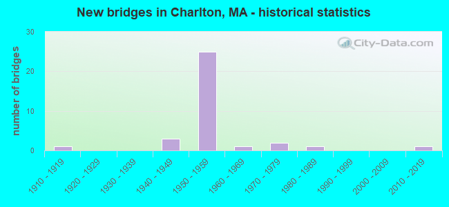
- New bridges - historical statistics
- 11910-1919
- 31940-1949
- 251950-1959
- 11960-1969
- 21970-1979
- 11980-1989
- 12010-2019

- Reconstructed bridges - Historical Statistics
- 21950-1959
- 01960-1969
- 01970-1979
- 61980-1989
- 11990-1999
- 22000-2009
- 12010-2019


- Bridge Condition - Deck
- 9.5%Very good
- 23.8%Good
- 42.9%Satisfactory
- 19.0%Fair
- 4.8%Poor

- Bridge Condition - Superstructure
- 9.1%Very good
- 9.1%Good
- 59.1%Satisfactory
- 18.2%Fair
- 4.5%Poor

- Bridge Condition - Substructure
- 4.5%Very good
- 54.5%Good
- 22.7%Satisfactory
- 18.2%Fair

- Bridge Condition - Channel
- 28.6%Good
- 57.1%Satisfactory
- 14.3%Fair

- Bridge Condition - Culverts
- 50.0%Good
- 50.0%Satisfactory
Find on map >> Show street view
Structure Number: C060031F6MUNNBI, Location: 0.3 MI N OF RT 20 (Lat: 42.157167, Lng: -71.914864), Route carried "on" structure: City street , Year Built: 1956, Year Reconstructed: 2010, Status: Open, Structure Length: 0.79m (2.59ft), Average Daily Traffic: 394 (year 1999), Truck Traffic: 2%, Average Future Daily Traffic: 632 (year 2031), Design Load: HS 25 or greater, Features Intersected: WATER LITTLE RIVER, Facility Carried by Structure: HWY GLENMERE RD
Minimum Vertical Clearance: 30+ m (98+ ft), Kilometerpoint: 1.529, Lanes on structure: 2, Owner: Town or Township Highway Agency, Approaching Roadway Width: 5.8m (19.0ft), Skew: 2 degrees, Material/Design: Wood or Timber, Design/Construction: Slab, Number Of Spans In Main Unit: 1, Length of Maximum Span: 7.3m (24.0ft), Curb or Sidewalk Widths: Left: 0.2m (0.7ft), Right: 0.2m (0.7ft), Curb-To-Curb Width: 5.9m (19.4ft), Out-to-Out Width: 6.2m (20.3ft)
Condition: Deck: Good, Superstructure: Good, Substructure: Good, Channel: Good, Inventory Rating: 96.7 metric tons, Method Used To Determine Inventory Rating: Load Factor (LF), Structural Evaluation: Better than present minimum criteria, Deck Geometry: High priority of corrective action, Waterway Adequacy: Better than present minimum criteria, Approach Roadway Alignment: Equal to present minimum criteria, Length Of Structure Improvement: 0.80m (2.62ft), Designated Inspection Frequency: Every 24 months, Inspection Date: September 2020, Bridge Improvement Cost: $385,000, Roadway Improvement Cost: $39,000, Total Project Cost: $578,000 ( Estimate for 2022), Deck Structure Type: Wood or Timber, Wearing Surface/Protective System: Wearing Surface: Bituminous
Find on map >> Show street view
Structure Number: C060061B9MUNNBI, Location: .8 MI. N. OF RTE-20 (Lat: 42.162417, Lng: -71.932669), Route carried "on" structure: City street , Year Built: 1956, Year Reconstructed: 2009, Status: Open, Structure Length: 0.69m (2.26ft), Average Daily Traffic: 1,742 (year 2020), Truck Traffic: 6%, Average Future Daily Traffic: 2,053 (year 2032), Design Load: H 15, Features Intersected: WATER LITTLE RIVER, Facility Carried by Structure: HWY HAMMOND HILL
Minimum Vertical Clearance: 30+ m (98+ ft), Kilometerpoint: 1.336, Lanes on structure: 2, Owner: Town or Township Highway Agency, Approaching Roadway Width: 6.7m (22.0ft), Material/Design: Prestressed concrete, Design/Construction: Slab, Number Of Spans In Main Unit: 1, Length of Maximum Span: 6.1m (20.0ft), Curb or Sidewalk Widths: Left: 1.5m (4.9ft), Right: 0.3m (1.0ft), Curb-To-Curb Width: 7.9m (25.9ft), Out-to-Out Width: 9.8m (32.2ft)
Condition: Deck: Good, Superstructure: Good, Substructure: Satisfactory, Channel: Satisfactory, Operating Rating: 91.7 metric tons, Method Used To Determine Operating Rating: Load Factor (LF), Inventory Rating: 64.8 metric tons, Method Used To Determine Inventory Rating: Load Factor (LF), Structural Evaluation: Equal to present minimum criteria, Deck Geometry: Meets minimum limits, Waterway Adequacy: Better than present minimum criteria, Approach Roadway Alignment: Better than present minimum criteria, Length Of Structure Improvement: 0.70m (2.30ft), Designated Inspection Frequency: Every 24 months, Inspection Date: June 2021, Bridge Improvement Cost: $363,000, Roadway Improvement Cost: $37,000, Total Project Cost: $545,000 ( Estimate for 2022), Deck Structure Type: Concrete Precast Panels, Wearing Surface/Protective System: Wearing Surface: Monolithic Concrete
Find on map >> Show street view
Structure Number: C060071F2MUNNBI, Location: 1.5 MI. S. OF ST 20 (Lat: 42.126342, Lng: -72.005289), Route carried "on" structure: City street , Year Built: 1956, Status: Open, Structure Length: 1.04m (3.41ft), Average Daily Traffic: 800 (year 2013), Truck Traffic: 1%, Average Future Daily Traffic: 1,263 (year 2032), Design Load: H 15, Features Intersected: WATER CADY BROOK, Facility Carried by Structure: HWY SNAKE HLL RD
Minimum Vertical Clearance: 30+ m (98+ ft), Kilometerpoint: 0.048, Lanes on structure: 2, Owner: Town or Township Highway Agency, Approaching Roadway Width: 7.9m (25.9ft), Skew: 1 degrees, Material/Design: Prestressed concrete, Design/Construction: Slab, Number Of Spans In Main Unit: 1, Length of Maximum Span: 9.8m (32.2ft), Curb or Sidewalk Widths: Left: 0.2m (0.7ft), Right: 0.2m (0.7ft), Curb-To-Curb Width: 8.0m (26.2ft), Out-to-Out Width: 8.6m (28.2ft)
Condition: Deck: Satisfactory, Superstructure: Satisfactory, Substructure: Good, Channel: Satisfactory, Operating Rating: 73.2 metric tons, Method Used To Determine Operating Rating: Load Factor (LF), Inventory Rating: 43.7 metric tons, Method Used To Determine Inventory Rating: Load Factor (LF), Structural Evaluation: Equal to present minimum criteria, Deck Geometry: Somewhat better than minimum adequacy, Waterway Adequacy: Better than present minimum criteria, Approach Roadway Alignment: Better than present minimum criteria, Length Of Structure Improvement: 1.10m (3.61ft), Designated Inspection Frequency: Every 24 months, Inspection Date: May 2021, Bridge Improvement Cost: $436,000, Roadway Improvement Cost: $44,000, Total Project Cost: $655,000 ( Estimate for 2022), Deck Structure Type: Concrete Precast Panels, Wearing Surface/Protective System: Wearing Surface: Bituminous, Membrane: Built-up
Find on map >> Show street view
Structure Number: C060081F4MUNNBI, Location: 100 FT E OF BLOOD RD (Lat: 42.087783, Lng: -71.985656), Route carried "on" structure: City street , Year Built: 1956, Status: Open, Structure Length: 0.82m (2.69ft), Average Daily Traffic: 2,490 (year 2018), Truck Traffic: 10%, Average Future Daily Traffic: 3,159 (year 2032), Design Load: H 15, Features Intersected: WATER KEENAN BROOK, Facility Carried by Structure: HWY SAUNDERSDALE
Minimum Vertical Clearance: 30+ m (98+ ft), Kilometerpoint: 1.448, Lanes on structure: 2, Owner: Town or Township Highway Agency, Approaching Roadway Width: 7.9m (25.9ft), Skew: 1 degrees, Material/Design: Prestressed concrete, Design/Construction: Slab, Number Of Spans In Main Unit: 1, Length of Maximum Span: 7.9m (25.9ft), Curb or Sidewalk Widths: Left: 0.3m (1.0ft), Right: 0.3m (1.0ft), Curb-To-Curb Width: 8.0m (26.2ft), Out-to-Out Width: 8.6m (28.2ft)
Condition: Deck: Satisfactory, Superstructure: Satisfactory, Substructure: Good, Channel: Satisfactory, Operating Rating: 90.7 metric tons, Method Used To Determine Operating Rating: Load Factor (LF), Inventory Rating: 54.4 metric tons, Method Used To Determine Inventory Rating: Load Factor (LF), Structural Evaluation: Equal to present minimum criteria, Deck Geometry: High priority of corrective action, Waterway Adequacy: Better than present minimum criteria, Approach Roadway Alignment: Equal to present minimum criteria, Length Of Structure Improvement: 0.90m (2.95ft), Designated Inspection Frequency: Every 24 months, Inspection Date: June 2021, Bridge Improvement Cost: $459,000, Roadway Improvement Cost: $46,000, Total Project Cost: $689,000 ( Estimate for 2022), Deck Structure Type: Concrete Precast Panels, Wearing Surface/Protective System: Wearing Surface: Bituminous, Membrane: Built-up
Find on map >> Show street view
Structure Number: C0601121LDOT634, Location: .3 MI. N. OF CEMETARY RD. (Lat: 42.178647, Lng: -71.957011), Route carried "on" structure: City street , Year Built: 1978, Status: Open, Structure Length: 1.89m (6.20ft), Average Daily Traffic: 260 (year 2018), Truck Traffic: 1%, Average Future Daily Traffic: 411 (year 2033), Design Load: H 20, Features Intersected: RR CSX, Facility Carried by Structure: HWY GOULD RD
Minimum Vertical Clearance: 30+ m (98+ ft), Kilometerpoint: 1.448, Lanes on structure: 2, Owner: State Highway Agency, Approaching Roadway Width: 8.5m (27.9ft), Material/Design: Prestressed concrete, Design/Construction: Box Beam or Girders - Multiple, Number Of Spans In Main Unit: 1, Length of Maximum Span: 17.1m (56.1ft), Curb or Sidewalk Widths: Left: 1.4m (4.6ft), Right: 0.0m, Curb-To-Curb Width: 8.5m (27.9ft), Out-to-Out Width: 11.4m (37.4ft)
Condition: Deck: Satisfactory, Superstructure: Satisfactory, Substructure: Satisfactory, Operating Rating: 66.3 metric tons, Method Used To Determine Operating Rating: Load Factor (LF), Inventory Rating: 39.7 metric tons, Method Used To Determine Inventory Rating: Load Factor (LF), Structural Evaluation: Equal to present minimum criteria, Deck Geometry: Equal to present minimum criteria, Underclear: Somewhat better than minimum adequacy, Approach Roadway Alignment: Equal to present minimum criteria, Length Of Structure Improvement: 1.90m (6.23ft), Designated Inspection Frequency: Every 24 months, Inspection Date: Febuary 2022, Bridge Improvement Cost: $448,000, Roadway Improvement Cost: $45,000, Total Project Cost: $673,000 ( Estimate for 2022), Deck Structure Type: Concrete Precast Panels, Wearing Surface/Protective System: Wearing Surface: Bituminous, Membrane: Built-up
Find on map >> Show street view
Structure Number: C0601221HDOT634, Location: 1.4 MI SW OF OXFORD T.L (Lat: 42.175381, Lng: -71.935364), Route carried "on" structure: City street , Year Built: 1914, Year Reconstructed: 1985, Status: Open, Structure Length: 1.89m (6.20ft), Average Daily Traffic: 3,851 (year 2018), Truck Traffic: 6%, Average Future Daily Traffic: 9,855 (year 2033), Design Load: HS 20, Features Intersected: RR CSX, Facility Carried by Structure: HWY STAFFORD ST
Minimum Vertical Clearance: 30+ m (98+ ft), Kilometerpoint: 5.954, Lanes on structure: 2, Owner: State Highway Agency, Approaching Roadway Width: 12.2m (40.0ft), Skew: 2 degrees, Material/Design: Prestressed concrete, Design/Construction: Slab, Number Of Spans In Main Unit: 1, Length of Maximum Span: 16.5m (54.1ft), Curb or Sidewalk Widths: Left: 1.5m (4.9ft), Right: 0.2m (0.7ft), Curb-To-Curb Width: 12.2m (40.0ft), Out-to-Out Width: 14.8m (48.6ft)
Condition: Deck: Fair, Superstructure: Fair, Substructure: Good, Operating Rating: 66.3 metric tons, Method Used To Determine Operating Rating: Load Factor (LF), Inventory Rating: 39.7 metric tons, Method Used To Determine Inventory Rating: Load Factor (LF), Structural Evaluation: Somewhat better than minimum adequacy, Deck Geometry: Equal to present minimum criteria, Underclear: Superior to present desirable criteria, Approach Roadway Alignment: Equal to present desirable criteria, Length Of Structure Improvement: 1.90m (6.23ft), Designated Inspection Frequency: Every 24 months, Inspection Date: Febuary 2022, Bridge Improvement Cost: $1,105,000, Roadway Improvement Cost: $111,000, Total Project Cost: $1,658,000 ( Estimate for 2022), Deck Structure Type: Concrete Precast Panels, Wearing Surface/Protective System: Wearing Surface: Latex Concrete
Find on map >> Show street view
Structure Number: C06013BC6DOT634, Location: .5MI E. OF ST.31 (Lat: 42.172769, Lng: -71.968142), Route carried "on" structure: City street , Year Built: 2012, Status: Open, Structure Length: 2.45m (8.04ft), Average Daily Traffic: 500 (year 2016), Truck Traffic: 6%, Design Load: HS 20, Features Intersected: RR CSX, Facility Carried by Structure: HWY JONES RD
Minimum Vertical Clearance: 30+ m (98+ ft), Kilometerpoint: 0.000, Lanes on structure: 2, Owner: State Highway Agency, Approaching Roadway Width: 7.9m (25.9ft), Material/Design: Steel, Design/Construction: Stringer/Multi-beam, Number Of Spans In Main Unit: 1, Length of Maximum Span: 23.2m (76.1ft), Curb-To-Curb Width: 7.9m (25.9ft), Out-to-Out Width: 8.8m (28.9ft)
Condition: Deck: Very good, Superstructure: Very good, Substructure: Very good, Operating Rating: 45.4 metric tons, Method Used To Determine Operating Rating: Load and Resistance Factor Rating (LRFR) rating reported by rating factor(RF) method using HL-93 loadings, Inventory Rating: 35.6 metric tons, Method Used To Determine Inventory Rating: Load and Resistance Factor Rating (LRFR) rating reported by rating factor(RF) method using HL-93 loadings, Structural Evaluation: Equal to present desirable criteria, Deck Geometry: Somewhat better than minimum adequacy, Underclear: Somewhat better than minimum adequacy, Approach Roadway Alignment: Meets minimum limits, Length Of Structure Improvement: 2.50m (8.20ft), Designated Inspection Frequency: Every 24 months, Inspection Date: August 2020, Bridge Improvement Cost: $1,009,000, Roadway Improvement Cost: $101,000, Total Project Cost: $1,514,000 ( Estimate for 2022), Deck Structure Type: Concrete Cast-file-Place, Wearing Surface/Protective System: Wearing Surface: Bituminous, Membrane: Built-up, Deck Protection: Epoxy Coated Reinforcing
Find on map >> Show street view
Structure Number: C0601421JDOT634, Location: 100FT S. OF OLD SPENCER R (Lat: 42.174292, Lng: -71.977839), Route carried "on" structure: State highway 31, Year Built: 1954, Year Reconstructed: 2011, Status: Open, Structure Length: 1.68m (5.51ft), Average Daily Traffic: 2,805 (year 2011), Truck Traffic: 7%, Average Future Daily Traffic: 4,738 (year 2031), Design Load: HS 20, Features Intersected: RR CSX
Minimum Vertical Clearance: 30+ m (98+ ft), Kilometerpoint: 18.732, Lanes on structure: 2, Owner: State Highway Agency, Approaching Roadway Width: 12.2m (40.0ft), Material/Design: Steel, Design/Construction: Stringer/Multi-beam, Number Of Spans In Main Unit: 1, Length of Maximum Span: 15.7m (51.5ft), Curb or Sidewalk Widths: Left: 1.5m (4.9ft), Right: 0.0m, Curb-To-Curb Width: 12.2m (40.0ft), Out-to-Out Width: 14.6m (47.9ft)
Condition: Deck: Very good, Superstructure: Very good, Substructure: Good, Operating Rating: 71.3 metric tons, Method Used To Determine Operating Rating: Load and Resistance Factor Rating (LRFR) rating reported by rating factor(RF) method using HL-93 loadings, Inventory Rating: 55.1 metric tons, Method Used To Determine Inventory Rating: Load and Resistance Factor Rating (LRFR) rating reported by rating factor(RF) method using HL-93 loadings, Structural Evaluation: Better than present minimum criteria, Deck Geometry: Equal to present minimum criteria, Underclear: Somewhat better than minimum adequacy, Approach Roadway Alignment: Equal to present desirable criteria, Length Of Structure Improvement: 1.70m (5.58ft), Designated Inspection Frequency: Every 24 months, Inspection Date: June 2020, Bridge Improvement Cost: $193,000, Roadway Improvement Cost: $20,000, Total Project Cost: $290,000 ( Estimate for 2022), Deck Structure Type: Concrete Cast-file-Place, Wearing Surface/Protective System: Wearing Surface: Bituminous, Membrane: Built-up, Deck Protection: Epoxy Coated Reinforcing
Find on map >> Show street view
Structure Number: C060151Y7DOTNBI, Location: 1.3MI.N.OF SOUTHBRIDG TL. (Lat: 42.119353, Lng: -72.008864), Route carried "on" structure: State highway 169, Year Built: 1948, Year Reconstructed: 1956, Status: Open, Structure Length: 0.91m (2.99ft), Average Daily Traffic: 11,786 (year 2011), Truck Traffic: 7%, Average Future Daily Traffic: 28,664 (year 2032), Design Load: H 20, Features Intersected: WATER CADY BROOK
Minimum Vertical Clearance: 30+ m (98+ ft), Kilometerpoint: 11.587, Lanes on structure: 2, Base Highway Network: Yes, Owner: State Highway Agency, Approaching Roadway Width: 11.9m (39.0ft), Skew: 1 degrees, Material/Design: Concrete, Design/Construction: Frame, Number Of Spans In Main Unit: 1, Length of Maximum Span: 7.9m (25.9ft), Curb or Sidewalk Widths: Left: 0.2m (0.7ft), Right: 0.2m (0.7ft), Curb-To-Curb Width: 12.2m (40.0ft), Out-to-Out Width: 13.3m (43.6ft)
Condition: Superstructure: Fair, Substructure: Fair, Channel: Satisfactory, Operating Rating: 70.0 metric tons, Method Used To Determine Operating Rating: Load Factor (LF), Inventory Rating: 42.0 metric tons, Method Used To Determine Inventory Rating: Load Factor (LF), Structural Evaluation: Somewhat better than minimum adequacy, Deck Geometry: Somewhat better than minimum adequacy, Waterway Adequacy: Equal to present desirable criteria, Approach Roadway Alignment: Equal to present desirable criteria, Length Of Structure Improvement: 1.00m (3.28ft), Designated Inspection Frequency: Every 24 months, Inspection Date: June 2021, Bridge Improvement Cost: $523,000, Roadway Improvement Cost: $53,000, Total Project Cost: $785,000 ( Estimate for 2022)
Find on map >> Show street view
Structure Number: C060161Y6DOTNBI, Location: .6 MI N OF SOUTHBRIDGE TL (Lat: 42.110519, Lng: -72.013344), Route carried "on" structure: State highway 169, Year Built: 1947, Year Reconstructed: 1956, Status: Open, Structure Length: 1.66m (5.45ft), Average Daily Traffic: 11,967 (year 2019), Truck Traffic: 5%, Average Future Daily Traffic: 26,611 (year 2031), Design Load: H 20, Features Intersected: WATER CADY BROOK
Minimum Vertical Clearance: 30+ m (98+ ft), Kilometerpoint: 10.493, Lanes on structure: 2, Base Highway Network: Yes, Owner: State Highway Agency, Approaching Roadway Width: 12.2m (40.0ft), Skew: 4 degrees, Material/Design: Steel, Design/Construction: Stringer/Multi-beam, Number Of Spans In Main Unit: 1, Length of Maximum Span: 15.2m (49.9ft), Curb or Sidewalk Widths: Left: 0.2m (0.7ft), Right: 0.2m (0.7ft), Curb-To-Curb Width: 12.2m (40.0ft), Out-to-Out Width: 13.3m (43.6ft)
Condition: Deck: Fair, Superstructure: Satisfactory, Substructure: Fair, Channel: Good, Operating Rating: 44.1 metric tons, Method Used To Determine Operating Rating: Load Factor (LF), Inventory Rating: 26.4 metric tons, Method Used To Determine Inventory Rating: Load Factor (LF), Structural Evaluation: Somewhat better than minimum adequacy, Deck Geometry: Somewhat better than minimum adequacy, Waterway Adequacy: Better than present minimum criteria, Approach Roadway Alignment: Equal to present desirable criteria, Length Of Structure Improvement: 1.70m (5.58ft), Designated Inspection Frequency: Every 24 months, Inspection Date: June 2020, Bridge Improvement Cost: $889,000, Roadway Improvement Cost: $89,000, Total Project Cost: $1,334,000 ( Estimate for 2022), Deck Structure Type: Concrete Cast-file-Place, Wearing Surface/Protective System: Wearing Surface: Bituminous
Find on map >> Show street view
Structure Number: C060171F5MUNNBI, Location: 0.3 MI N OF ST-20 (Lat: 42.157333, Lng: -71.915517), Route carried "on" structure: City street , Year Built: 1979, Status: Open, Structure Length: 0.73m (2.40ft), Average Daily Traffic: 300 (year 2013), Truck Traffic: 3%, Average Future Daily Traffic: 474 (year 2032), Features Intersected: WATER LITTLE RIVER, Facility Carried by Structure: HWY OXBOW RD
Minimum Vertical Clearance: 30+ m (98+ ft), Kilometerpoint: 0.933, Lanes on structure: 2, Owner: Town or Township Highway Agency, Approaching Roadway Width: 7.3m (24.0ft), Skew: 2 degrees, Material/Design: Aluminum, Iron, Design/Construction: Culvert, Number Of Spans In Main Unit: 2, Length of Maximum Span: 3.0m (9.8ft)
Condition: Channel: Satisfactory, Culverts: Good, Operating Rating: 95.6 metric tons, Method Used To Determine Operating Rating: Load Factor (LF), Inventory Rating: 57.3 metric tons, Method Used To Determine Inventory Rating: Load Factor (LF), Structural Evaluation: Better than present minimum criteria, Waterway Adequacy: Equal to present minimum criteria, Approach Roadway Alignment: Better than present minimum criteria, Length Of Structure Improvement: 0.50m (1.64ft), Designated Inspection Frequency: Every 24 months, Inspection Date: June 2021, Bridge Improvement Cost: $312,000, Roadway Improvement Cost: $32,000, Total Project Cost: $469,000 ( Estimate for 2022)
Find on map >> Show street view
Structure Number: C060181Y8DOTNBI, Location: .5 MI.STH OF U.S.20 (Lat: 42.138872, Lng: -71.999097), Route carried "on" structure: State highway 169, Year Built: 1947, Status: Open, Structure Length: 0.76m (2.49ft), Average Daily Traffic: 11,786 (year 2011), Truck Traffic: 10%, Average Future Daily Traffic: 25,269 (year 2031), Design Load: H 20, Features Intersected: WATER ASHWORTH BROOK
Minimum Vertical Clearance: 30+ m (98+ ft), Kilometerpoint: 13.904, Lanes on structure: 2, Base Highway Network: Yes, Owner: State Highway Agency, Approaching Roadway Width: 12.2m (40.0ft), Skew: 3 degrees, Material/Design: Concrete, Design/Construction: Culvert, Number Of Spans In Main Unit: 1, Length of Maximum Span: 6.7m (22.0ft), Curb or Sidewalk Widths: Left: 0.2m (0.7ft), Right: 0.2m (0.7ft), Curb-To-Curb Width: 12.2m (40.0ft), Out-to-Out Width: 13.4m (44.0ft)
Condition: Channel: Good, Culverts: Satisfactory, Operating Rating: 51.4 metric tons, Method Used To Determine Operating Rating: Load Factor (LF), Inventory Rating: 22.1 metric tons, Method Used To Determine Inventory Rating: Load Factor (LF), Structural Evaluation: Somewhat better than minimum adequacy, Deck Geometry: Somewhat better than minimum adequacy, Waterway Adequacy: Better than present minimum criteria, Approach Roadway Alignment: Equal to present desirable criteria, Length Of Structure Improvement: 1.50m (4.92ft), Designated Inspection Frequency: Every 24 months, Inspection Date: May 2020, Bridge Improvement Cost: $388,000, Roadway Improvement Cost: $39,000, Total Project Cost: $583,000 ( Estimate for 2022)
Find on map >> Show street view
Structure Number: C060191LFDOTNBI, Location: 50 FT E OF ST-169 (Lat: 42.144719, Lng: -71.994031), Route carried "on" structure: US 20, Year Built: 1957, Status: Open, Structure Length: 1.31m (4.30ft), Average Daily Traffic: 19,092 (year 2020), Truck Traffic: 6%, Average Future Daily Traffic: 31,586 (year 2032), Design Load: H 20, Features Intersected: WATER CADY BROOK
Minimum Vertical Clearance: 30+ m (98+ ft), Kilometerpoint: 159.900, Lanes on structure: 3, Base Highway Network: Yes, Owner: State Highway Agency, Approaching Roadway Width: 16.8m (55.1ft), Skew: 1 degrees, Material/Design: Prestressed concrete, Design/Construction: Slab, Number Of Spans In Main Unit: 1, Length of Maximum Span: 11.9m (39.0ft), Curb or Sidewalk Widths: Left: 0.3m (1.0ft), Right: 1.5m (4.9ft), Curb-To-Curb Width: 16.8m (55.1ft), Out-to-Out Width: 18.6m (61.0ft)
Condition: Deck: Poor, Superstructure: Poor, Substructure: Fair, Channel: Fair, Operating Rating: 67.0 metric tons, Method Used To Determine Operating Rating: Load Factor (LF), Inventory Rating: 33.9 metric tons, Method Used To Determine Inventory Rating: Load Factor (LF), Structural Evaluation: Meets minimum limits, Deck Geometry: Superior to present desirable criteria, Waterway Adequacy: Equal to present desirable criteria, Approach Roadway Alignment: Equal to present desirable criteria, Length Of Structure Improvement: 1.40m (4.59ft), Designated Inspection Frequency: Every 12 months, Other Special Inspection Frequency: Every 12 months, Inspection Date: August 2021, Other Special Inspection Date: August 2021, Bridge Improvement Cost: $1,023,000, Roadway Improvement Cost: $103,000, Total Project Cost: $1,535,000 ( Estimate for 2022), Deck Structure Type: Concrete Precast Panels, Wearing Surface/Protective System: Wearing Surface: Bituminous, Membrane: Built-up
Find on map >> Show street view
Structure Number: C060231LEDOTNBI, Location: .5 MI W OF OXFORD T.L. (Lat: 42.154494, Lng: -71.912206), Route carried "on" structure: US 20, Year Built: 1957, Year Reconstructed: 1992, Status: Open, Structure Length: 1.98m (6.50ft), Average Daily Traffic: 24,096 (year 2018), Truck Traffic: 5%, Average Future Daily Traffic: 45,800 (year 2032), Design Load: HS 20, Features Intersected: WATER LITTLE RIVER
Minimum Vertical Clearance: 30+ m (98+ ft), Kilometerpoint: 0.000, Lanes on structure: 4, Base Highway Network: Yes, Owner: State Highway Agency, Approaching Roadway Width: 15.8m (51.8ft), Material/Design: Steel, Design/Construction: Stringer/Multi-beam, Number Of Spans In Main Unit: 1, Length of Maximum Span: 11.9m (39.0ft), Curb-To-Curb Width: 15.8m (51.8ft), Out-to-Out Width: 17.7m (58.1ft)
Condition: Deck: Good, Superstructure: Fair, Substructure: Satisfactory, Channel: Fair, Operating Rating: 82.7 metric tons, Method Used To Determine Operating Rating: Load Factor (LF), Inventory Rating: 49.5 metric tons, Method Used To Determine Inventory Rating: Load Factor (LF), Structural Evaluation: Somewhat better than minimum adequacy, Deck Geometry: Meets minimum limits, Waterway Adequacy: Equal to present desirable criteria, Approach Roadway Alignment: Equal to present desirable criteria, Length Of Structure Improvement: 2.00m (6.56ft), Designated Inspection Frequency: Every 24 months, Inspection Date: August 2021, Bridge Improvement Cost: $1,391,000, Roadway Improvement Cost: $140,000, Total Project Cost: $2,087,000 ( Estimate for 2022), Deck Structure Type: Concrete Cast-file-Place, Wearing Surface/Protective System: Wearing Surface: Latex Concrete, Deck Protection: Epoxy Coated Reinforcing
Find on map >> Show street view
Structure Number: C060241F1MUNNBI, Location: .1 MI N OF SAUNDERSDALE R (Lat: 42.090467, Lng: -71.985417), Route carried "on" structure: City street , Year Built: 1956, Status: Open, Structure Length: 0.95m (3.12ft), Average Daily Traffic: 150 (year 2013), Truck Traffic: 1%, Average Future Daily Traffic: 237 (year 2032), Design Load: H 15, Features Intersected: WATER KEENAN BROOK, Facility Carried by Structure: HWY BLOOD RD
Minimum Vertical Clearance: 30+ m (98+ ft), Kilometerpoint: 0.193, Lanes on structure: 2, Owner: Town or Township Highway Agency, Approaching Roadway Width: 7.9m (25.9ft), Skew: 2 degrees, Material/Design: Prestressed concrete, Design/Construction: Slab, Number Of Spans In Main Unit: 1, Length of Maximum Span: 9.1m (29.9ft), Curb-To-Curb Width: 7.9m (25.9ft), Out-to-Out Width: 8.5m (27.9ft)
Condition: Deck: Satisfactory, Superstructure: Satisfactory, Substructure: Good, Channel: Satisfactory, Operating Rating: 71.0 metric tons, Method Used To Determine Operating Rating: Load Factor (LF), Inventory Rating: 42.4 metric tons, Method Used To Determine Inventory Rating: Load Factor (LF), Structural Evaluation: Equal to present minimum criteria, Deck Geometry: Somewhat better than minimum adequacy, Waterway Adequacy: Equal to present minimum criteria, Approach Roadway Alignment: Equal to present minimum criteria, Length Of Structure Improvement: 1.00m (3.28ft), Designated Inspection Frequency: Every 24 months, Inspection Date: May 2021, Bridge Improvement Cost: $293,000, Roadway Improvement Cost: $30,000, Total Project Cost: $440,000 ( Estimate for 2022), Deck Structure Type: Concrete Precast Panels, Wearing Surface/Protective System: Wearing Surface: Bituminous, Membrane: Built-up
Find on map >> Show street view
Structure Number: C060271F0MUNNBI, Location: .3 MI N OF SAUNDERDALE RD (Lat: 42.092947, Lng: -71.985350), Route carried "on" structure: City street , Year Built: 1956, Status: Open, Structure Length: 0.77m (2.53ft), Average Daily Traffic: 150 (year 2013), Truck Traffic: 1%, Average Future Daily Traffic: 237 (year 2032), Design Load: H 15, Features Intersected: WATER KEENAN BROOK, Facility Carried by Structure: HWY BLOOD RD
Minimum Vertical Clearance: 30+ m (98+ ft), Kilometerpoint: 0.595, Lanes on structure: 2, Owner: Town or Township Highway Agency, Approaching Roadway Width: 7.9m (25.9ft), Skew: 1 degrees, Material/Design: Prestressed concrete, Design/Construction: Slab, Number Of Spans In Main Unit: 1, Length of Maximum Span: 7.4m (24.3ft), Curb or Sidewalk Widths: Left: 0.3m (1.0ft), Right: 0.3m (1.0ft), Curb-To-Curb Width: 7.9m (25.9ft), Out-to-Out Width: 8.5m (27.9ft)
Condition: Deck: Satisfactory, Superstructure: Satisfactory, Substructure: Good, Channel: Satisfactory, Operating Rating: 84.2 metric tons, Method Used To Determine Operating Rating: Load Factor (LF), Inventory Rating: 50.5 metric tons, Method Used To Determine Inventory Rating: Load Factor (LF), Structural Evaluation: Equal to present minimum criteria, Deck Geometry: Somewhat better than minimum adequacy, Waterway Adequacy: Better than present minimum criteria, Approach Roadway Alignment: High priority of corrective action, Length Of Structure Improvement: 1.50m (4.92ft), Designated Inspection Frequency: Every 24 months, Inspection Date: May 2021, Bridge Improvement Cost: $913,000, Roadway Improvement Cost: $92,000, Total Project Cost: $1,370,000 ( Estimate for 2022), Deck Structure Type: Concrete Precast Panels, Wearing Surface/Protective System: Wearing Surface: Bituminous, Membrane: Built-up
Find on map >> Show street view
Structure Number: C060364L7DOTNBI, Location: MASS PIKE MM 82.3 (Lat: 42.151322, Lng: -71.992011), Route carried "on" structure: Interstate 90, Year Built: 1957, Year Reconstructed: 1986, Status: Open, Structure Length: 1.55m (5.09ft), Average Daily Traffic: 53,498 (year 2019), Truck Traffic: 16%, Average Future Daily Traffic: 78,965 (year 2032), Design Load: HS 20+Mod, Features Intersected: HWY BROOKFIELD RD
Minimum Vertical Clearance: 30+ m (98+ ft), Kilometerpoint: 132.445, Lanes on structure: 3, Lanes under structure: 2, Base Highway Network: Yes, Toll: On toll road, Owner: State Highway Agency, Approaching Roadway Width: 16.0m (52.5ft), Skew: 2 degrees, Material/Design: Steel, Design/Construction: Stringer/Multi-beam, Number Of Spans In Main Unit: 1, Length of Maximum Span: 14.0m (45.9ft), Curb-To-Curb Width: 16.0m (52.5ft), Out-to-Out Width: 17.2m (56.4ft)
Condition: Deck: Satisfactory, Superstructure: Satisfactory, Substructure: Good, Operating Rating: 67.4 metric tons, Method Used To Determine Operating Rating: Load Factor (LF), Inventory Rating: 40.4 metric tons, Method Used To Determine Inventory Rating: Load Factor (LF), Structural Evaluation: Equal to present minimum criteria, Deck Geometry: Equal to present minimum criteria, Underclear: High priority of corrective action, Approach Roadway Alignment: Better than present minimum criteria, Length Of Structure Improvement: 1.60m (5.25ft), Designated Inspection Frequency: Every 24 months, Inspection Date: March 2020, Bridge Improvement Cost: $363,000, Roadway Improvement Cost: $37,000, Total Project Cost: $545,000 ( Estimate for 2022), Deck Structure Type: Concrete Cast-file-Place, Wearing Surface/Protective System: Wearing Surface: Bituminous, Membrane: Built-up, Deck Protection: Epoxy Coated Reinforcing
Find on map >> Show street view
Structure Number: C060364L8DOTNBI, Location: .7 MI W OF STAFFORD ST (Lat: 42.151464, Lng: -71.992156), Route carried "on" structure: Interstate 90, Year Built: 1957, Year Reconstructed: 1986, Status: Open, Structure Length: 1.55m (5.09ft), Average Daily Traffic: 52,522 (year 2019), Truck Traffic: 15%, Average Future Daily Traffic: 78,965 (year 2033), Design Load: HS 20, Features Intersected: HWY BROOKFIELD RD
Minimum Vertical Clearance: 30+ m (98+ ft), Kilometerpoint: 132.445, Lanes on structure: 3, Lanes under structure: 2, Base Highway Network: Yes, Toll: On toll road, Owner: State Highway Agency, Approaching Roadway Width: 16.0m (52.5ft), Skew: 2 degrees, Material/Design: Steel, Design/Construction: Stringer/Multi-beam, Number Of Spans In Main Unit: 1, Length of Maximum Span: 14.0m (45.9ft), Curb-To-Curb Width: 16.0m (52.5ft), Out-to-Out Width: 17.2m (56.4ft)
Condition: Deck: Fair, Superstructure: Fair, Substructure: Good, Operating Rating: 66.9 metric tons, Method Used To Determine Operating Rating: Load Factor (LF), Inventory Rating: 40.1 metric tons, Method Used To Determine Inventory Rating: Load Factor (LF), Structural Evaluation: Somewhat better than minimum adequacy, Deck Geometry: Equal to present minimum criteria, Underclear: High priority of corrective action, Approach Roadway Alignment: Better than present minimum criteria, Length Of Structure Improvement: 1.60m (5.25ft), Designated Inspection Frequency: Every 24 months, Inspection Date: March 2020, Bridge Improvement Cost: $1,081,000, Roadway Improvement Cost: $109,000, Total Project Cost: $1,622,000 ( Estimate for 2022), Deck Structure Type: Concrete Cast-file-Place, Wearing Surface/Protective System: Wearing Surface: Bituminous, Membrane: Built-up, Deck Protection: Epoxy Coated Reinforcing
Find on map >> Show street view
Structure Number: C060374L5DOTNBI, Location: I-90 MM 82.6 (Lat: 42.152517, Lng: -71.985578), Route carried "on" structure: Interstate 90, Year Built: 1957, Year Reconstructed: 1986, Status: Open, Structure Length: 6.10m (20.01ft), Average Daily Traffic: 39,545 (year 2020), Truck Traffic: 21%, Average Future Daily Traffic: 75,033 (year 2032), Design Load: HS 20, Features Intersected: ST 31 CITY DEPOT RD
Minimum Vertical Clearance: 30+ m (98+ ft), Kilometerpoint: 132.928, Lanes on structure: 3, Lanes under structure: 2, Base Highway Network: Yes, Toll: On toll road, Owner: State Highway Agency, Approaching Roadway Width: 15.2m (49.9ft), Skew: 11 degrees, Material/Design: Steel continuous, Design/Construction: Stringer/Multi-beam, Number Of Spans In Main Unit: 3, Length of Maximum Span: 19.8m (65.0ft), Curb-To-Curb Width: 15.2m (49.9ft), Out-to-Out Width: 17.4m (57.1ft)
Condition: Deck: Satisfactory, Superstructure: Satisfactory, Substructure: Satisfactory, Operating Rating: 50.6 metric tons, Method Used To Determine Operating Rating: Load Factor (LF), Inventory Rating: 30.3 metric tons, Method Used To Determine Inventory Rating: Load Factor (LF), Structural Evaluation: Equal to present minimum criteria, Deck Geometry: Meets minimum limits, Underclear: High priority of corrective action, Approach Roadway Alignment: Equal to present desirable criteria, Length Of Structure Improvement: 6.20m (20.34ft), Designated Inspection Frequency: Every 24 months, Inspection Date: March 2021, Bridge Improvement Cost: $4,238,000, Roadway Improvement Cost: $424,000, Total Project Cost: $6,358,000 ( Estimate for 2022), Deck Structure Type: Concrete Cast-file-Place, Wearing Surface/Protective System: Wearing Surface: Bituminous, Membrane: Built-up, Deck Protection: Epoxy Coated Reinforcing
Find on map >> Show street view
Structure Number: C060374L6DOTNBI, Location: AT I-90 MM 82.6 (Lat: 42.152703, Lng: -71.985547), Route carried "on" structure: Interstate 90, Year Built: 1957, Year Reconstructed: 1986, Status: Open, Structure Length: 6.10m (20.01ft), Average Daily Traffic: 51,843 (year 2018), Truck Traffic: 15%, Average Future Daily Traffic: 75,033 (year 2032), Design Load: HS 20, Features Intersected: ST 31 CITY DEPOT RD
Minimum Vertical Clearance: 30+ m (98+ ft), Kilometerpoint: 132.928, Lanes on structure: 3, Lanes under structure: 2, Base Highway Network: Yes, Toll: On toll road, Owner: State Highway Agency, Approaching Roadway Width: 15.2m (49.9ft), Skew: 11 degrees, Material/Design: Steel continuous, Design/Construction: Stringer/Multi-beam, Number Of Spans In Main Unit: 3, Length of Maximum Span: 19.8m (65.0ft), Curb-To-Curb Width: 15.2m (49.9ft), Out-to-Out Width: 17.4m (57.1ft)
Condition: Deck: Satisfactory, Superstructure: Satisfactory, Substructure: Good, Operating Rating: 63.7 metric tons, Method Used To Determine Operating Rating: Load Factor (LF), Inventory Rating: 38.2 metric tons, Method Used To Determine Inventory Rating: Load Factor (LF), Structural Evaluation: Equal to present minimum criteria, Deck Geometry: Meets minimum limits, Underclear: High priority of corrective action, Approach Roadway Alignment: Equal to present desirable criteria, Length Of Structure Improvement: 6.20m (20.34ft), Designated Inspection Frequency: Every 24 months, Inspection Date: March 2021, Bridge Improvement Cost: $1,871,000, Roadway Improvement Cost: $188,000, Total Project Cost: $2,807,000 ( Estimate for 2022), Deck Structure Type: Concrete Cast-file-Place, Wearing Surface/Protective System: Wearing Surface: Bituminous, Membrane: Built-up, Deck Protection: Epoxy Coated Reinforcing
Find on map >> Show street view
Structure Number: C060384L4DOTNBI, Location: .4 MI W. ST 31 J3 (Lat: 42.153111, Lng: -71.978300), Route carried "on" structure: City street , Year Built: 1957, Year Reconstructed: 2001, Status: Open, Structure Length: 8.29m (27.20ft), Average Daily Traffic: 3,446 (year 2020), Truck Traffic: 5%, Average Future Daily Traffic: 6,633 (year 2032), Design Load: HS 20, Features Intersected: I 90, Facility Carried by Structure: HWY STAFFORD ST
Minimum Vertical Clearance: 30+ m (98+ ft), Kilometerpoint: 133.572, Lanes on structure: 2, Lanes under structure: 6, Owner: State Highway Agency, Approaching Roadway Width: 9.1m (29.9ft), Skew: 4 degrees, Material/Design: Steel continuous, Design/Construction: Stringer/Multi-beam, Number Of Spans In Main Unit: 2, Number Of Approach Spans: 2, Length of Maximum Span: 25.0m (82.0ft), Curb or Sidewalk Widths: Left: 1.5m (4.9ft), Right: 0.8m (2.6ft), Curb-To-Curb Width: 9.1m (29.9ft), Out-to-Out Width: 12.3m (40.4ft)
Condition: Deck: Good, Superstructure: Satisfactory, Substructure: Good, Operating Rating: 77.2 metric tons, Method Used To Determine Operating Rating: Load Factor (LF), Inventory Rating: 46.2 metric tons, Method Used To Determine Inventory Rating: Load Factor (LF), Structural Evaluation: Equal to present minimum criteria, Deck Geometry: Meets minimum limits, Underclear: High priority of corrective action, Approach Roadway Alignment: Equal to present desirable criteria, Length Of Structure Improvement: 8.30m (27.23ft), Designated Inspection Frequency: Every 24 months, Inspection Date: September 2021, Bridge Improvement Cost: $3,365,000, Roadway Improvement Cost: $337,000, Total Project Cost: $5,048,000 ( Estimate for 2022), Deck Structure Type: Concrete Cast-file-Place, Wearing Surface/Protective System: Wearing Surface: Bituminous, Membrane: Built-up, Deck Protection: Epoxy Coated Reinforcing
Find on map >> Show street view
Structure Number: C060394L3DOTNBI, Location: MM 83.4 (Lat: 42.153539, Lng: -71.970983), Route carried "on" structure: City street , Year Built: 1957, Status: Open, Structure Length: 8.32m (27.30ft), Average Daily Traffic: 3,446 (year 2020), Truck Traffic: 7%, Average Future Daily Traffic: 4,264 (year 2032), Design Load: HS 20, Features Intersected: I 90, Facility Carried by Structure: HWY CENTER DEPOT
Minimum Vertical Clearance: 99.00m (324.80ft), Kilometerpoint: 134.216, Lanes on structure: 2, Lanes under structure: 6, Owner: State Highway Agency, Approaching Roadway Width: 9.1m (29.9ft), Skew: 3 degrees, Material/Design: Steel continuous, Design/Construction: Stringer/Multi-beam, Number Of Spans In Main Unit: 4, Length of Maximum Span: 22.6m (74.1ft), Curb or Sidewalk Widths: Left: 1.5m (4.9ft), Right: 0.8m (2.6ft), Curb-To-Curb Width: 9.1m (29.9ft), Out-to-Out Width: 12.3m (40.4ft)
Condition: Deck: Satisfactory, Superstructure: Satisfactory, Substructure: Good, Operating Rating: 49.7 metric tons, Method Used To Determine Operating Rating: Load Factor (LF), Inventory Rating: 29.8 metric tons, Method Used To Determine Inventory Rating: Load Factor (LF), Structural Evaluation: Equal to present minimum criteria, Deck Geometry: Meets minimum limits, Underclear: High priority of corrective action, Approach Roadway Alignment: Equal to present desirable criteria, Length Of Structure Improvement: 8.40m (27.56ft), Designated Inspection Frequency: Every 24 months, Inspection Date: September 2021, Bridge Improvement Cost: $4,059,000, Roadway Improvement Cost: $406,000, Total Project Cost: $6,089,000 ( Estimate for 2022), Deck Structure Type: Concrete Cast-file-Place, Wearing Surface/Protective System: Wearing Surface: Bituminous, Membrane: Built-up, Deck Protection: Epoxy Coated Reinforcing
Find on map >> Show street view
Structure Number: C060404L2DOTNBI, Location: 0.3 MI. S. OF STAFFORD ST (Lat: 42.160064, Lng: -71.954581), Route carried "on" structure: City street , Year Built: 1957, Status: Open, Structure Length: 8.02m (26.31ft), Average Daily Traffic: 910 (year 2018), Truck Traffic: 6%, Average Future Daily Traffic: 205 (year 2032), Design Load: HS 20, Features Intersected: I 90, Facility Carried by Structure: HWY NORTHSIDE RD
Minimum Vertical Clearance: 30+ m (98+ ft), Kilometerpoint: 135.664, Lanes on structure: 2, Lanes under structure: 6, Owner: State Highway Agency, Approaching Roadway Width: 7.3m (24.0ft), Skew: 3 degrees, Material/Design: Steel, Design/Construction: Stringer/Multi-beam, Number Of Spans In Main Unit: 4, Length of Maximum Span: 24.9m (81.7ft), Curb or Sidewalk Widths: Left: 0.5m (1.6ft), Right: 0.8m (2.6ft), Curb-To-Curb Width: 7.3m (24.0ft), Out-to-Out Width: 9.4m (30.8ft)
Condition: Deck: Fair, Superstructure: Satisfactory, Substructure: Fair, Operating Rating: 38.4 metric tons, Method Used To Determine Operating Rating: Load Factor (LF), Inventory Rating: 23.0 metric tons, Method Used To Determine Inventory Rating: Load Factor (LF), Structural Evaluation: Somewhat better than minimum adequacy, Deck Geometry: Meets minimum limits, Underclear: High priority of corrective action, Approach Roadway Alignment: Equal to present desirable criteria, Length Of Structure Improvement: 8.10m (26.57ft), Designated Inspection Frequency: Every 24 months, Inspection Date: September 2021, Bridge Improvement Cost: $2,991,000, Roadway Improvement Cost: $300,000, Total Project Cost: $4,487,000 ( Estimate for 2022), Deck Structure Type: Concrete Cast-file-Place, Wearing Surface/Protective System: Wearing Surface: Monolithic Concrete
Find on map >> Show street view
Structure Number: C060414L1DOTNBI, Location: 1.3 MI W OXFORD TWN LN (Lat: 42.167844, Lng: -71.937097), Route carried "on" structure: Interstate 90, Year Built: 1957, Status: Open, Structure Length: 7.32m (24.02ft), Average Daily Traffic: 2,120 (year 2018), Truck Traffic: 5%, Average Future Daily Traffic: 3,474 (year 2032), Design Load: HS 20, Features Intersected: I 90, Facility Carried by Structure: HWY HAMMOND HILL
Minimum Vertical Clearance: 30+ m (98+ ft), Kilometerpoint: 137.434, Lanes on structure: 2, Lanes under structure: 6, Owner: State Highway Agency, Approaching Roadway Width: 8.5m (27.9ft), Skew: 1 degrees, Material/Design: Steel continuous, Design/Construction: Stringer/Multi-beam, Number Of Spans In Main Unit: 4, Length of Maximum Span: 19.4m (63.6ft), Curb-To-Curb Width: 8.6m (28.2ft), Out-to-Out Width: 9.4m (30.8ft)
Condition: Deck: Good, Superstructure: Satisfactory, Substructure: Satisfactory, Operating Rating: 60.0 metric tons, Method Used To Determine Operating Rating: Load Factor (LF), Inventory Rating: 35.9 metric tons, Method Used To Determine Inventory Rating: Load Factor (LF), Structural Evaluation: Equal to present minimum criteria, Deck Geometry: Meets minimum limits, Underclear: High priority of corrective action, Approach Roadway Alignment: Equal to present desirable criteria, Length Of Structure Improvement: 7.40m (24.28ft), Designated Inspection Frequency: Every 24 months, Inspection Date: September 2021, Bridge Improvement Cost: $3,377,000, Roadway Improvement Cost: $338,000, Total Project Cost: $5,066,000 ( Estimate for 2022), Deck Structure Type: Concrete Cast-file-Place, Wearing Surface/Protective System: Wearing Surface: Bituminous, Membrane: Built-up, Deck Protection: Epoxy Coated Reinforcing
Find on map >> Show street view
Structure Number: C060421F7MUNNBI, Location: .2MI S OF POTTER VILL RD. (Lat: 42.092153, Lng: -71.915242), Route carried "on" structure: City street , Year Built: 1960, Status: Open, Structure Length: 1.34m (4.40ft), Average Daily Traffic: 130 (year 2017), Truck Traffic: 1%, Average Future Daily Traffic: 205 (year 2032), Features Intersected: WATER PRPNT MEDW OUT, Facility Carried by Structure: HWY BEACH RD
Minimum Vertical Clearance: 30+ m (98+ ft), Kilometerpoint: 0.322, Lanes on structure: 2, Owner: Town or Township Highway Agency, Approaching Roadway Width: 9.1m (29.9ft), Skew: 4 degrees, Material/Design: Concrete, Design/Construction: Culvert, Number Of Spans In Main Unit: 3, Length of Maximum Span: 4.0m (13.1ft), Curb-To-Curb Width: 9.1m (29.9ft), Out-to-Out Width: 9.1m (29.9ft)
Condition: Channel: Good, Culverts: Satisfactory, Operating Rating: 68.6 metric tons, Method Used To Determine Operating Rating: Allowable Stress (AS), Inventory Rating: 46.0 metric tons, Method Used To Determine Inventory Rating: Allowable Stress (AS), Structural Evaluation: Equal to present minimum criteria, Deck Geometry: Equal to present minimum criteria, Waterway Adequacy: Better than present minimum criteria, Approach Roadway Alignment: Better than present minimum criteria, Length Of Structure Improvement: 0.30m (0.98ft), Designated Inspection Frequency: Every 24 months, Inspection Date: November 2021, Bridge Improvement Cost: $291,000, Roadway Improvement Cost: $30,000, Total Project Cost: $437,000 ( Estimate for 2022), Deck Structure Type: Concrete Cast-file-Place, Wearing Surface/Protective System: Wearing Surface: Bituminous
Find on map >> Show street view
Structure Number: C060431F8MUNNBI, Location: 1.4MI. W. OF DRESSERHILL (Lat: 42.083522, Lng: -71.989144), Route carried "on" structure: City street , Year Built: 1986, Status: Open, Structure Length: 0.64m (2.10ft), Average Daily Traffic: 2,490 (year 2018), Truck Traffic: 6%, Average Future Daily Traffic: 1,895 (year 2032), Features Intersected: WATER DEANS BROOK, Facility Carried by Structure: HWY SAUNDERSDALE
Minimum Vertical Clearance: 30+ m (98+ ft), Kilometerpoint: 0.805, Lanes on structure: 2, Owner: Town or Township Highway Agency, Approaching Roadway Width: 10.4m (34.1ft), Material/Design: Concrete, Design/Construction: Culvert, Number Of Spans In Main Unit: 2, Length of Maximum Span: 3.4m (11.2ft), Curb-To-Curb Width: 11.5m (37.7ft), Out-to-Out Width: 13.0m (42.7ft)
Condition: Channel: Satisfactory, Culverts: Good, Operating Rating: 31.9 metric tons, Method Used To Determine Operating Rating: Load Factor (LF), Inventory Rating: 19.2 metric tons, Method Used To Determine Inventory Rating: Load Factor (LF), Structural Evaluation: Somewhat better than minimum adequacy, Deck Geometry: Somewhat better than minimum adequacy, Waterway Adequacy: Better than present minimum criteria, Approach Roadway Alignment: Better than present minimum criteria, Bridge Posting: Required (Relationship of Operating Rating to Maximum Legal Load: 0.1 - 9.9% below), Length Of Structure Improvement: 1.20m (3.94ft), Designated Inspection Frequency: Every 24 months, Inspection Date: November 2021, Bridge Improvement Cost: $302,000, Roadway Improvement Cost: $31,000, Total Project Cost: $454,000 ( Estimate for 2022)
Find on map >> Show street view
Structure Number: C060384L4DOTNBI, Location: .2MI.W.DEPOT RD (Lat: 42.150000, Lng: -71.983333), Route carried "under" structure: Interstate 90, Year Built: 1957, Structure Length: 0. m, Average Daily Traffic: 32,545 (year 0000), Features Intersected: I 90 EB, Facility Carried by Structure: HWY STAFFORD ST
Minimum Vertical Clearance: 4.29m (14.07ft), Kilometerpoint: 133.572, Lanes on structure: 2, Lanes under structure: 3, Toll: On toll road, Material/Design: Steel, Design/Construction: Stringer/Multi-beam, Length of Maximum Span: 25.0m (82.0ft)
Find on map >> Show street view
Structure Number: C060384L4DOTNBI, Location: .2MI.W.DEPOT RD (Lat: 42.150000, Lng: -71.983333), Route carried "under" structure: Interstate 90, Year Built: 1957, Structure Length: 0. m, Average Daily Traffic: 32,573 (year 0000), Features Intersected: I 90 WB, Facility Carried by Structure: HWY STAFFORD ST
Minimum Vertical Clearance: 4.27m (14.01ft), Kilometerpoint: 133.572, Lanes on structure: 2, Lanes under structure: 3, Toll: On toll road, Material/Design: Steel, Design/Construction: Stringer/Multi-beam, Length of Maximum Span: 25.0m (82.0ft)
Find on map >> Show street view
Structure Number: C060394L3DOTNBI, Location: .3MI.N.STURBRIDGE RD (Lat: 42.150000, Lng: -71.966667), Route carried "under" structure: Interstate 90, Year Built: 1957, Structure Length: 0. m, Average Daily Traffic: 32,573 (year 0000), Features Intersected: I 90 WB, Facility Carried by Structure: HWY N MAIN ST
Minimum Vertical Clearance: 4.27m (14.01ft), Kilometerpoint: 134.216, Lanes on structure: 2, Lanes under structure: 3, Toll: On toll road, Material/Design: Steel, Design/Construction: Stringer/Multi-beam, Length of Maximum Span: 22.6m (74.1ft)
Find on map >> Show street view
Structure Number: C060394L3DOTNBI, Location: .3MI.N.STURBRIDGE RD (Lat: 42.150000, Lng: -71.966667), Route carried "under" structure: Interstate 90, Year Built: 1957, Structure Length: 0. m, Average Daily Traffic: 32,545 (year 0000), Features Intersected: I 90 EB, Facility Carried by Structure: HWY N MAIN ST
Minimum Vertical Clearance: 4.27m (14.01ft), Kilometerpoint: 134.216, Lanes on structure: 2, Lanes under structure: 3, Toll: On toll road, Material/Design: Steel, Design/Construction: Stringer/Multi-beam, Length of Maximum Span: 22.6m (74.1ft)
Find on map >> Show street view
Structure Number: C060404L2DOTNBI, Location: .2MI.S.STAFFORD ST (Lat: 42.166667, Lng: -71.950000), Route carried "under" structure: Interstate 90, Year Built: 1957, Structure Length: 0. m, Average Daily Traffic: 32,545 (year 0000), Features Intersected: I 90 EB, Facility Carried by Structure: HWY NORTHSIDE RD
Minimum Vertical Clearance: 4.27m (14.01ft), Kilometerpoint: 135.664, Lanes on structure: 2, Lanes under structure: 3, Toll: On toll road, Material/Design: Steel, Design/Construction: Stringer/Multi-beam, Length of Maximum Span: 25.0m (82.0ft)
Find on map >> Show street view
Structure Number: C060404L2DOTNBI, Location: .2MI.S.STAFFORD ST (Lat: 42.166667, Lng: -71.950000), Route carried "under" structure: Interstate 90, Year Built: 1957, Structure Length: 0. m, Average Daily Traffic: 32,573 (year 0000), Features Intersected: I 90 WB, Facility Carried by Structure: HWY NORTHSIDE RD
Minimum Vertical Clearance: 4.27m (14.01ft), Kilometerpoint: 135.664, Lanes on structure: 2, Lanes under structure: 3, Toll: On toll road, Material/Design: Steel, Design/Construction: Stringer/Multi-beam, Length of Maximum Span: 25.0m (82.0ft)
Find on map >> Show street view
Structure Number: C060414L1DOTNBI, Location: .1MI.S.STAFFORD ST (Lat: 42.166667, Lng: -71.933333), Route carried "under" structure: Interstate 90, Year Built: 1957, Structure Length: 0. m, Average Daily Traffic: 32,545 (year 0000), Features Intersected: I 90 EB, Facility Carried by Structure: HWY HAMND HLL RD
Minimum Vertical Clearance: 4.47m (14.67ft), Kilometerpoint: 137.434, Lanes on structure: 2, Lanes under structure: 3, Toll: On toll road, Material/Design: Steel, Design/Construction: Stringer/Multi-beam, Length of Maximum Span: 19.5m (64.0ft)
Find on map >> Show street view
Structure Number: C060414L1DOTNBI, Location: .1MI.S.STAFFORD ST (Lat: 42.166667, Lng: -71.933333), Route carried "under" structure: Interstate 90, Year Built: 1957, Structure Length: 0. m, Average Daily Traffic: 32,573 (year 0000), Features Intersected: I 90 WB, Facility Carried by Structure: HWY HAMND HLL RD
Minimum Vertical Clearance: 4.47m (14.67ft), Kilometerpoint: 137.434, Lanes on structure: 2, Lanes under structure: 3, Toll: On toll road, Material/Design: Steel, Design/Construction: Stringer/Multi-beam, Length of Maximum Span: 19.5m (64.0ft)