Bridge Statistics for Chamblee, Georgia (GA)
Condition, Traffic, Stress, Structural Evaluation, Project Costs
- National Bridge Inventory (NBI) Statistics
- 36Number of bridges
- 404ft / 123mTotal length
- $81,389,000Total costs
- 1,689,816Total average daily traffic
- 18,418Total average daily truck traffic
- National Bridge Inventory (NBI) Registered Bridges for Chamblee
- No street view available for this location
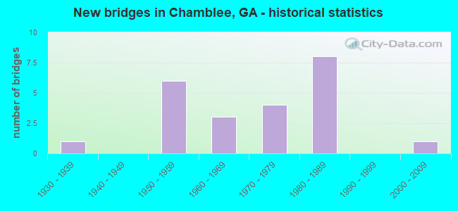
- New bridges - historical statistics
- 11930-1939
- 61950-1959
- 31960-1969
- 41970-1979
- 81980-1989
- 12000-2009

- Reconstructed bridges - Historical Statistics
- 11960-1969
- 11970-1979
- 11980-1989


- Bridge Condition - Deck
- 7.1%Very good
- 71.4%Good
- 21.4%Satisfactory

- Bridge Condition - Superstructure
- 35.7%Very good
- 57.1%Good
- 7.1%Satisfactory

- Bridge Condition - Substructure
- 7.1%Very good
- 85.7%Good
- 7.1%Satisfactory

- Bridge Condition - Channel
- 40.0%Very good
- 33.3%Good
- 26.7%Satisfactory

- Bridge Condition - Culverts
- 11.1%Very good
- 88.9%Good
Find on map >> Show street view
Structure Number: 890036, Location: IN WEST CHAMBLEE (Lat: 33.888669, Lng: -84.313308), Route carried "on" structure: State highway 141, Year Built: 1955, Year Reconstructed: 1985, Status: Open, Structure Length: 0.67m (2.20ft), Average Daily Traffic: 36,040 (year 2011), Truck Traffic: 1%, Average Future Daily Traffic: 54,060 (year 2031), Design Load: H 15, Features Intersected: PEDESTRIAN WALKWAY, Facility Carried by Structure: P'TREE IND. BLVD.
Minimum Vertical Clearance: 30+ m (98+ ft), Kilometerpoint: 4.828, Lanes on structure: 6, Base Highway Network: Yes, Owner: State Highway Agency, Approaching Roadway Width: 18.9m (62.0ft), Material/Design: Concrete, Design/Construction: Slab, Number Of Spans In Main Unit: 1, Length of Maximum Span: 6.7m (22.0ft), Curb or Sidewalk Widths: Left: 0.0m, Right: 1.8m (5.9ft), Curb-To-Curb Width: 25.7m (84.3ft), Out-to-Out Width: 28.8m (94.5ft)
Condition: Deck: Good, Superstructure: Good, Substructure: Good, Operating Rating: 30.8 metric tons, Method Used To Determine Operating Rating: Allowable Stress (AS), Inventory Rating: 19.9 metric tons, Method Used To Determine Inventory Rating: Allowable Stress (AS), Structural Evaluation: Somewhat better than minimum adequacy, Deck Geometry: Somewhat better than minimum adequacy, Approach Roadway Alignment: Equal to present desirable criteria, Designated Inspection Frequency: Every 24 months, Inspection Date: September 2020, Bridge Improvement Cost: $180,000, Roadway Improvement Cost: $18,000, Total Project Cost: $270,000, Deck Structure Type: Concrete Cast-file-Place, Wearing Surface/Protective System: Wearing Surface: Bituminous, Membrane: Built-up
Find on map >> Show street view
Structure Number: 890065, Location: 3 MI S OF CHAMBLEE (Lat: 33.849497, Lng: -84.303203), Route carried "on" structure: Interstate 85, Year Built: 1980, Status: Open, Structure Length: 11.61m (38.09ft), Average Daily Traffic: 200,150 (year 2011), Truck Traffic: 1%, Average Future Daily Traffic: 300,225 (year 2031), Design Load: HS 20+Mod, Features Intersected: N F P'TREE CR- 2 U-TURNS
Minimum Vertical Clearance: 30+ m (98+ ft), Kilometerpoint: 148.060, Lanes on structure: 12, Lanes under structure: 2, Base Highway Network: Yes, Owner: State Highway Agency, Approaching Roadway Width: 51.2m (168.0ft), Skew: 32 degrees, Material/Design: Steel, Design/Construction: Stringer/Multi-beam, Number Of Spans In Main Unit: 3, Length of Maximum Span: 43.3m (142.1ft), Curb-To-Curb Width: 51.2m (168.0ft), Out-to-Out Width: 52.1m (170.9ft)
Condition: Deck: Good, Superstructure: Very good, Substructure: Good, Channel: Very good, Operating Rating: 50.8 metric tons, Method Used To Determine Operating Rating: Load Factor (LF), Inventory Rating: 29.9 metric tons, Method Used To Determine Inventory Rating: Load Factor (LF), Structural Evaluation: Better than present minimum criteria, Deck Geometry: Better than present minimum criteria, Underclear: High priority of corrective action, Waterway Adequacy: Equal to present desirable criteria, Approach Roadway Alignment: Equal to present desirable criteria, Designated Inspection Frequency: Every 24 months, Inspection Date: June 2020, Bridge Improvement Cost: $5,549,000, Roadway Improvement Cost: $555,000, Total Project Cost: $8,323,000, Deck Structure Type: Concrete Cast-file-Place, Wearing Surface/Protective System: Deck Protection: Epoxy Coated Reinforcing
Find on map >> Show street view
Structure Number: 890067, Location: 2.1 MI SE OF CHAMBLEE (Lat: 33.864442, Lng: -84.289003), Route carried "on" structure: Ramp Interstate 85, Year Built: 1980, Status: Open, Structure Length: 5.58m (18.31ft), Average Daily Traffic: 2,202 (year 2011), Truck Traffic: 1%, Average Future Daily Traffic: 3,303 (year 2031), Design Load: HS 20+Mod, Features Intersected: I-85
Minimum Vertical Clearance: 30+ m (98+ ft), Kilometerpoint: 149.669, Lanes on structure: 1, Lanes under structure: 12, Base Highway Network: Yes, Owner: State Highway Agency, Approaching Roadway Width: 7.9m (25.9ft), Material/Design: Steel continuous, Design/Construction: Stringer/Multi-beam, Number Of Spans In Main Unit: 2, Length of Maximum Span: 28.0m (91.9ft), Curb-To-Curb Width: 8.5m (27.9ft), Out-to-Out Width: 10.0m (32.8ft)
Condition: Deck: Good, Superstructure: Good, Substructure: Good, Operating Rating: 48.9 metric tons, Method Used To Determine Operating Rating: Load Factor (LF), Inventory Rating: 29.0 metric tons, Method Used To Determine Inventory Rating: Load Factor (LF), Structural Evaluation: Better than present minimum criteria, Deck Geometry: Superior to present desirable criteria, Underclear: Meets minimum limits, Approach Roadway Alignment: Equal to present desirable criteria, Designated Inspection Frequency: Every 24 months, Inspection Date: June 2020, Bridge Improvement Cost: $520,000, Roadway Improvement Cost: $52,000, Total Project Cost: $780,000, Deck Structure Type: Concrete Cast-file-Place, Wearing Surface/Protective System: Deck Protection: Epoxy Coated Reinforcing
Find on map >> Show street view
Structure Number: 890068, Location: 2.1 MI SE OF CHAMBLEE (Lat: 33.864750, Lng: -84.288619), Route carried "on" structure: Ramp Interstate 85, Year Built: 1980, Status: Open, Structure Length: 5.58m (18.31ft), Average Daily Traffic: 2,202 (year 2011), Truck Traffic: 1%, Average Future Daily Traffic: 3,303 (year 2031), Design Load: HS 20+Mod, Features Intersected: I-85
Minimum Vertical Clearance: 30+ m (98+ ft), Kilometerpoint: 149.669, Lanes on structure: 1, Lanes under structure: 12, Base Highway Network: Yes, Owner: State Highway Agency, Approaching Roadway Width: 9.1m (29.9ft), Material/Design: Steel continuous, Design/Construction: Stringer/Multi-beam, Number Of Spans In Main Unit: 2, Length of Maximum Span: 28.0m (91.9ft), Curb-To-Curb Width: 8.5m (27.9ft), Out-to-Out Width: 10.0m (32.8ft)
Condition: Deck: Good, Superstructure: Very good, Substructure: Good, Operating Rating: 48.0 metric tons, Method Used To Determine Operating Rating: Load Factor (LF), Inventory Rating: 29.0 metric tons, Method Used To Determine Inventory Rating: Load Factor (LF), Structural Evaluation: Better than present minimum criteria, Deck Geometry: Superior to present desirable criteria, Underclear: Meets minimum limits, Approach Roadway Alignment: Equal to present desirable criteria, Designated Inspection Frequency: Every 24 months, Inspection Date: June 2020, Bridge Improvement Cost: $520,000, Roadway Improvement Cost: $52,000, Total Project Cost: $780,000, Deck Structure Type: Concrete Cast-file-Place, Wearing Surface/Protective System: Deck Protection: Epoxy Coated Reinforcing
Find on map >> Show street view
Structure Number: 890069, Location: 1.7 MI S OF CHAMBLEE (Lat: 33.878628, Lng: -84.272978), Route carried "on" structure: Ramp Interstate 85, Year Built: 1980, Status: Open, Structure Length: 6.40m (21.00ft), Average Daily Traffic: 2,202 (year 2011), Truck Traffic: 1%, Average Future Daily Traffic: 3,303 (year 2031), Design Load: HS 20+Mod, Features Intersected: I-85
Minimum Vertical Clearance: 30+ m (98+ ft), Kilometerpoint: 151.278, Lanes on structure: 1, Lanes under structure: 10, Base Highway Network: Yes, Owner: State Highway Agency, Approaching Roadway Width: 8.8m (28.9ft), Material/Design: Steel, Design/Construction: Stringer/Multi-beam, Number Of Spans In Main Unit: 2, Length of Maximum Span: 33.5m (109.9ft), Curb-To-Curb Width: 9.1m (29.9ft), Out-to-Out Width: 10.6m (34.8ft)
Condition: Deck: Good, Superstructure: Good, Substructure: Good, Operating Rating: 29.0 metric tons, Method Used To Determine Operating Rating: Load Factor (LF), Inventory Rating: 17.2 metric tons, Method Used To Determine Inventory Rating: Load Factor (LF), Structural Evaluation: Meets minimum limits, Deck Geometry: Superior to present desirable criteria, Underclear: Meets minimum limits, Approach Roadway Alignment: Equal to present desirable criteria, Designated Inspection Frequency: Every 24 months, Inspection Date: August 2020, Bridge Improvement Cost: $597,000, Roadway Improvement Cost: $60,000, Total Project Cost: $895,000, Deck Structure Type: Concrete Cast-file-Place
Find on map >> Show street view
Structure Number: 890172, Location: 3 MI S OF CHAMBLEE (Lat: 33.849736, Lng: -84.303564), Route carried "on" structure: City street 9216, Year Built: 1980, Status: Open, Structure Length: 5.21m (17.09ft), Average Daily Traffic: 2,202 (year 2011), Truck Traffic: 1%, Average Future Daily Traffic: 3,303 (year 2031), Design Load: HS 20+Mod, Features Intersected: N FORK PEACHTREE CREEK, Facility Carried by Structure: S/B ACCESS ROAD
Minimum Vertical Clearance: 30+ m (98+ ft), Kilometerpoint: 3.219, Lanes on structure: 2, Base Highway Network: Yes, Owner: State Highway Agency, Approaching Roadway Width: 9.1m (29.9ft), Skew: 2 degrees, Material/Design: Steel continuous, Design/Construction: Stringer/Multi-beam, Number Of Spans In Main Unit: 3, Length of Maximum Span: 20.4m (66.9ft), Curb or Sidewalk Widths: Left: 1.7m (5.6ft), Right: 0.0m, Curb-To-Curb Width: 11.0m (36.1ft), Out-to-Out Width: 13.5m (44.3ft)
Condition: Deck: Good, Superstructure: Good, Substructure: Good, Channel: Very good, Operating Rating: 51.7 metric tons, Method Used To Determine Operating Rating: Load Factor (LF), Inventory Rating: 30.8 metric tons, Method Used To Determine Inventory Rating: Load Factor (LF), Structural Evaluation: Better than present minimum criteria, Deck Geometry: Equal to present minimum criteria, Waterway Adequacy: Equal to present desirable criteria, Approach Roadway Alignment: Equal to present desirable criteria, Designated Inspection Frequency: Every 24 months, Inspection Date: June 2020, Bridge Improvement Cost: $668,000, Roadway Improvement Cost: $67,000, Total Project Cost: $1,002,000, Deck Structure Type: Concrete Cast-file-Place, Wearing Surface/Protective System: Deck Protection: Epoxy Coated Reinforcing
Find on map >> Show street view
Structure Number: 890173, Location: 3 MI S OF CHAMBLEE (Lat: 33.849328, Lng: -84.302869), Route carried "on" structure: City street 9217, Year Built: 1980, Status: Open, Structure Length: 5.21m (17.09ft), Average Daily Traffic: 5,150 (year 2011), Truck Traffic: 1%, Average Future Daily Traffic: 7,725 (year 2031), Design Load: HS 20+Mod, Features Intersected: N FORK PEACHTREE CREEK, Facility Carried by Structure: N/B ACCESS ROAD
Minimum Vertical Clearance: 30+ m (98+ ft), Kilometerpoint: 3.219, Lanes on structure: 2, Base Highway Network: Yes, Owner: State Highway Agency, Approaching Roadway Width: 9.1m (29.9ft), Skew: 2 degrees, Material/Design: Steel continuous, Design/Construction: Stringer/Multi-beam, Number Of Spans In Main Unit: 3, Length of Maximum Span: 20.4m (66.9ft), Curb or Sidewalk Widths: Left: 0.0m, Right: 1.7m (5.6ft), Curb-To-Curb Width: 11.0m (36.1ft), Out-to-Out Width: 13.5m (44.3ft)
Condition: Deck: Good, Superstructure: Very good, Substructure: Very good, Channel: Very good, Operating Rating: 45.3 metric tons, Method Used To Determine Operating Rating: Load Factor (LF), Inventory Rating: 27.2 metric tons, Method Used To Determine Inventory Rating: Load Factor (LF), Structural Evaluation: Equal to present minimum criteria, Deck Geometry: Equal to present minimum criteria, Waterway Adequacy: Equal to present desirable criteria, Approach Roadway Alignment: Equal to present desirable criteria, Designated Inspection Frequency: Every 24 months, Inspection Date: June 2020, Bridge Improvement Cost: $668,000, Roadway Improvement Cost: $67,000, Total Project Cost: $1,002,000, Deck Structure Type: Concrete Cast-file-Place, Wearing Surface/Protective System: Deck Protection: Epoxy Coated Reinforcing
Find on map >> Show street view
Structure Number: 890195, Location: 1.7 MI N OF CHAMBLEE (Lat: 33.918078, Lng: -84.304117), Route carried "on" structure: City street 9261, Year Built: 1964, Status: Open, Structure Length: 1.31m (4.30ft), Average Daily Traffic: 6,830 (year 2011), Truck Traffic: 2%, Average Future Daily Traffic: 10,245 (year 2031), Design Load: H 15, Features Intersected: NANCY CREEK, Facility Carried by Structure: N. SHALLOWFORD RD.
Minimum Vertical Clearance: 30+ m (98+ ft), Kilometerpoint: 1.609, Lanes on structure: 2, Base Highway Network: Yes, Owner: County Highway Agency, Approaching Roadway Width: 9.1m (29.9ft), Material/Design: Concrete, Design/Construction: Culvert, Number Of Spans In Main Unit: 4, Length of Maximum Span: 3.0m (9.8ft), Curb or Sidewalk Widths: Left: 1.2m (3.9ft), Right: 1.2m (3.9ft)
Condition: Channel: Satisfactory, Culverts: Good, Operating Rating: 43.5 metric tons, Method Used To Determine Operating Rating: Field evaluation and documented engineering judgment, Inventory Rating: 24.4 metric tons, Method Used To Determine Inventory Rating: Field evaluation and documented engineering judgment, Structural Evaluation: Equal to present minimum criteria, Waterway Adequacy: Equal to present desirable criteria, Approach Roadway Alignment: Better than present minimum criteria, Designated Inspection Frequency: Every 24 months, Inspection Date: August 2020, Bridge Improvement Cost: $168,000, Roadway Improvement Cost: $17,000, Total Project Cost: $252,000
Find on map >> Show street view
Structure Number: 890196, Location: 2 MI N OF CHAMBLEE (Lat: 33.918508, Lng: -84.297247), Route carried "on" structure: City street 9262, Year Built: 1964, Status: Open, Structure Length: 1.10m (3.61ft), Average Daily Traffic: 11,700 (year 2011), Truck Traffic: 1%, Average Future Daily Traffic: 17,550 (year 2031), Design Load: H 15, Features Intersected: NANCY CREEK, Facility Carried by Structure: NEW P'TREE ROAD
Minimum Vertical Clearance: 30+ m (98+ ft), Kilometerpoint: 4.828, Lanes on structure: 2, Base Highway Network: Yes, Owner: County Highway Agency, Approaching Roadway Width: 10.4m (34.1ft), Skew: 2 degrees, Material/Design: Concrete, Design/Construction: Culvert, Number Of Spans In Main Unit: 3, Length of Maximum Span: 3.4m (11.2ft)
Condition: Channel: Very good, Culverts: Good, Operating Rating: 43.5 metric tons, Method Used To Determine Operating Rating: Field evaluation and documented engineering judgment, Inventory Rating: 24.4 metric tons, Method Used To Determine Inventory Rating: Field evaluation and documented engineering judgment, Structural Evaluation: Equal to present minimum criteria, Waterway Adequacy: Equal to present desirable criteria, Approach Roadway Alignment: Better than present minimum criteria, Designated Inspection Frequency: Every 24 months, Inspection Date: August 2020, Bridge Improvement Cost: $141,000, Roadway Improvement Cost: $14,000, Total Project Cost: $211,000
Find on map >> Show street view
Structure Number: 890197, Location: 1.7 MI S OF DORAVILLE (Lat: 33.878803, Lng: -84.272892), Route carried "on" structure: City street 9265, Year Built: 1974, Status: Open, Structure Length: 6.46m (21.19ft), Average Daily Traffic: 23,800 (year 2011), Truck Traffic: 3%, Average Future Daily Traffic: 35,700 (year 2031), Design Load: HS 20+Mod, Features Intersected: I-85, Facility Carried by Structure: CHAMBLEE-TUCKER RD
Minimum Vertical Clearance: 30+ m (98+ ft), Kilometerpoint: 3.219, Lanes on structure: 6, Lanes under structure: 10, Base Highway Network: Yes, Owner: State Highway Agency, Approaching Roadway Width: 20.1m (65.9ft), Skew: 21 degrees, Material/Design: Steel, Design/Construction: Stringer/Multi-beam, Number Of Spans In Main Unit: 2, Length of Maximum Span: 33.8m (110.9ft), Curb or Sidewalk Widths: Left: 1.5m (4.9ft), Right: 1.5m (4.9ft), Curb-To-Curb Width: 24.4m (80.1ft), Out-to-Out Width: 28.2m (92.5ft)
Condition: Deck: Satisfactory, Superstructure: Good, Substructure: Good, Operating Rating: 73.4 metric tons, Method Used To Determine Operating Rating: Load Factor (LF), Inventory Rating: 44.4 metric tons, Method Used To Determine Inventory Rating: Load Factor (LF), Structural Evaluation: Better than present minimum criteria, Deck Geometry: Somewhat better than minimum adequacy, Underclear: Meets minimum limits, Approach Roadway Alignment: Equal to present desirable criteria, Designated Inspection Frequency: Every 24 months, Inspection Date: August 2020, Bridge Improvement Cost: $1,732,000, Roadway Improvement Cost: $173,000, Total Project Cost: $2,598,000, Deck Structure Type: Concrete Cast-file-Place, Wearing Surface/Protective System: Deck Protection: Epoxy Coated Reinforcing
Find on map >> Show street view
Structure Number: 890201, Location: 1.3 MI S OF CHAMBLEE (Lat: 33.870028, Lng: -84.294808), Route carried "on" structure: City street 9266, Year Built: 1968, Status: Open, Structure Length: 0.98m (3.22ft), Average Daily Traffic: 6,210 (year 2011), Truck Traffic: 1%, Average Future Daily Traffic: 9,315 (year 2031), Design Load: H 15, Features Intersected: N FORK P'TREE CREEK TRIB, Facility Carried by Structure: DRESDEN DRIVE
Minimum Vertical Clearance: 30+ m (98+ ft), Kilometerpoint: 4.828, Lanes on structure: 2, Base Highway Network: Yes, Owner: County Highway Agency, Approaching Roadway Width: 9.1m (29.9ft), Material/Design: Concrete, Design/Construction: Culvert, Number Of Spans In Main Unit: 3, Length of Maximum Span: 3.0m (9.8ft), Curb or Sidewalk Widths: Left: 0.0m, Right: 1.2m (3.9ft)
Condition: Channel: Satisfactory, Culverts: Good, Operating Rating: 43.5 metric tons, Method Used To Determine Operating Rating: Field evaluation and documented engineering judgment, Inventory Rating: 24.4 metric tons, Method Used To Determine Inventory Rating: Field evaluation and documented engineering judgment, Structural Evaluation: Equal to present minimum criteria, Waterway Adequacy: Equal to present minimum criteria, Approach Roadway Alignment: Equal to present minimum criteria, Designated Inspection Frequency: Every 24 months, Inspection Date: August 2020, Bridge Improvement Cost: $125,000, Roadway Improvement Cost: $13,000, Total Project Cost: $188,000
Find on map >> Show street view
Structure Number: 890202, Location: 2.3 MI SE OF CHAMBLEE (Lat: 33.862058, Lng: -84.286819), Route carried "on" structure: City street 9267, Year Built: 1958, Status: Open, Structure Length: 1.40m (4.59ft), Average Daily Traffic: 15,090 (year 2011), Truck Traffic: 1%, Average Future Daily Traffic: 22,635 (year 2031), Design Load: H 15, Features Intersected: N FORK PEACHTREE CREEK, Facility Carried by Structure: SHALLOWFORD ROAD
Minimum Vertical Clearance: 30+ m (98+ ft), Kilometerpoint: 1.609, Lanes on structure: 4, Base Highway Network: Yes, Owner: County Highway Agency, Approaching Roadway Width: 14.9m (48.9ft), Material/Design: Concrete, Design/Construction: Culvert, Number Of Spans In Main Unit: 4, Length of Maximum Span: 3.0m (9.8ft)
Condition: Channel: Good, Culverts: Good, Structural Evaluation: Better than present minimum criteria, Waterway Adequacy: Equal to present desirable criteria, Approach Roadway Alignment: Equal to present desirable criteria, Designated Inspection Frequency: Every 24 months, Inspection Date: July 2020, Bridge Improvement Cost: $278,000, Roadway Improvement Cost: $28,000, Total Project Cost: $417,000
Find on map >> Show street view
Structure Number: 890203, Location: 2.1 MI SE OF CHAMBLEE (Lat: 33.864581, Lng: -84.288794), Route carried "on" structure: City street 9267, Year Built: 1980, Status: Open, Structure Length: 5.55m (18.21ft), Average Daily Traffic: 16,830 (year 2011), Truck Traffic: 1%, Average Future Daily Traffic: 25,245 (year 2031), Design Load: HS 20+Mod, Features Intersected: I-85, Facility Carried by Structure: SHALLOWFORD ROAD
Minimum Vertical Clearance: 30+ m (98+ ft), Kilometerpoint: 1.609, Lanes on structure: 8, Lanes under structure: 12, Base Highway Network: Yes, Owner: State Highway Agency, Approaching Roadway Width: 31.4m (103.0ft), Skew: 10 degrees, Material/Design: Steel continuous, Design/Construction: Stringer/Multi-beam, Number Of Spans In Main Unit: 2, Length of Maximum Span: 27.7m (90.9ft), Curb or Sidewalk Widths: Left: 2.1m (6.9ft), Right: 2.1m (6.9ft), Curb-To-Curb Width: 31.7m (104.0ft), Out-to-Out Width: 36.7m (120.4ft)
Condition: Deck: Good, Superstructure: Very good, Substructure: Good, Operating Rating: 45.3 metric tons, Method Used To Determine Operating Rating: Load Factor (LF), Inventory Rating: 27.2 metric tons, Method Used To Determine Inventory Rating: Load Factor (LF), Structural Evaluation: Equal to present minimum criteria, Deck Geometry: Somewhat better than minimum adequacy, Underclear: Meets minimum limits, Approach Roadway Alignment: Equal to present desirable criteria, Designated Inspection Frequency: Every 24 months, Inspection Date: June 2020, Bridge Improvement Cost: $1,875,000, Roadway Improvement Cost: $187,000, Total Project Cost: $2,812,000, Deck Structure Type: Concrete Cast-file-Place, Wearing Surface/Protective System: Deck Protection: Epoxy Coated Reinforcing
Find on map >> Show street view
Structure Number: 890247, Location: 1.3 MI S OF CHAMBLEE (Lat: 33.875000, Lng: -84.294189), Route carried "on" structure: State highway 13, Year Built: 1935, Year Reconstructed: 1971, Status: Open, Structure Length: 1.37m (4.49ft), Average Daily Traffic: 20,730 (year 2011), Truck Traffic: 1%, Average Future Daily Traffic: 31,095 (year 2031), Design Load: H 15, Features Intersected: N FORK P'TREE CREEK TRIB, Facility Carried by Structure: BUFORD HIGHWAY
Minimum Vertical Clearance: 30+ m (98+ ft), Kilometerpoint: 8.047, Lanes on structure: 7, Base Highway Network: Yes, Owner: State Highway Agency, Approaching Roadway Width: 24.4m (80.1ft), Skew: 9 degrees, Material/Design: Concrete, Design/Construction: Culvert, Number Of Spans In Main Unit: 2, Length of Maximum Span: 6.7m (22.0ft)
Condition: Channel: Good, Culverts: Good, Operating Rating: 43.5 metric tons, Method Used To Determine Operating Rating: Field evaluation and documented engineering judgment, Inventory Rating: 24.4 metric tons, Method Used To Determine Inventory Rating: Field evaluation and documented engineering judgment, Structural Evaluation: Equal to present minimum criteria, Waterway Adequacy: Equal to present minimum criteria, Approach Roadway Alignment: Equal to present desirable criteria, Designated Inspection Frequency: Every 24 months, Inspection Date: August 2020, Bridge Improvement Cost: $416,000, Roadway Improvement Cost: $42,000, Total Project Cost: $623,000
Find on map >> Show street view
Structure Number: 89025, Location: IN CHAMBLEE (Lat: 33.893039, Lng: -84.300153), Route carried "on" structure: City street 9262, Year Built: 1977, Status: Open, Structure Length: 2.23m (7.32ft), Average Daily Traffic: 6,160 (year 2011), Truck Traffic: 1%, Average Future Daily Traffic: 9,240 (year 2031), Design Load: HS 20, Features Intersected: CHAMBLEE DUNWOODY ROAD, Facility Carried by Structure: PEACHTREE ROAD
Minimum Vertical Clearance: 30+ m (98+ ft), Kilometerpoint: 1.609, Lanes on structure: 2, Lanes under structure: 4, Base Highway Network: Yes, Owner: County Highway Agency, Approaching Roadway Width: 11.9m (39.0ft), Material/Design: Steel, Design/Construction: Stringer/Multi-beam, Number Of Spans In Main Unit: 1, Length of Maximum Span: 22.3m (73.2ft), Curb or Sidewalk Widths: Left: 1.9m (6.2ft), Right: 1.9m (6.2ft), Curb-To-Curb Width: 15.8m (51.8ft), Out-to-Out Width: 20.4m (66.9ft)
Condition: Deck: Good, Superstructure: Good, Substructure: Good, Operating Rating: 75.2 metric tons, Method Used To Determine Operating Rating: Allowable Stress (AS), Inventory Rating: 44.4 metric tons, Method Used To Determine Inventory Rating: Allowable Stress (AS), Structural Evaluation: Better than present minimum criteria, Deck Geometry: Superior to present desirable criteria, Underclear: High priority of corrective action, Approach Roadway Alignment: Better than present minimum criteria, Designated Inspection Frequency: Every 24 months, Inspection Date: September 2020, Bridge Improvement Cost: $285,000, Roadway Improvement Cost: $29,000, Total Project Cost: $428,000, Deck Structure Type: Concrete Cast-file-Place
Find on map >> Show street view
Structure Number: 890267, Location: IN CHAMBLEE (Lat: 33.886978, Lng: -84.311478), Route carried "on" structure: City street 9014, Year Built: 1986, Status: Open, Structure Length: 41.76m (137.01ft), Average Daily Traffic: 13,170 (year 2011), Truck Traffic: 1%, Average Future Daily Traffic: 19,755 (year 2031), Design Load: HS 20+Mod, Features Intersected: M-9262- MARTA- NS. RR., Facility Carried by Structure: CLARMONT ROAD
Minimum Vertical Clearance: 30+ m (98+ ft), Kilometerpoint: 3.219, Lanes on structure: 5, Lanes under structure: 2, Base Highway Network: Yes, Owner: City or Municipal Highway Agency, Approaching Roadway Width: 19.5m (64.0ft), Material/Design: Prestressed concrete, Design/Construction: Stringer/Multi-beam, Number Of Spans In Main Unit: 16, Length of Maximum Span: 27.4m (89.9ft), Curb or Sidewalk Widths: Left: 1.8m (5.9ft), Right: 1.8m (5.9ft), Curb-To-Curb Width: 19.5m (64.0ft), Out-to-Out Width: 23.9m (78.4ft)
Condition: Deck: Good, Superstructure: Good, Substructure: Good, Operating Rating: 52.6 metric tons, Method Used To Determine Operating Rating: Load Factor (LF), Inventory Rating: 31.7 metric tons, Method Used To Determine Inventory Rating: Load Factor (LF), Structural Evaluation: Better than present minimum criteria, Deck Geometry: Meets minimum limits, Underclear: High priority of corrective action, Approach Roadway Alignment: Equal to present minimum criteria, Designated Inspection Frequency: Every 24 months, Inspection Date: September 2020, Bridge Improvement Cost: $9,732,000, Roadway Improvement Cost: $973,000, Total Project Cost: $14,599,000, Deck Structure Type: Concrete Cast-file-Place
Find on map >> Show street view
Structure Number: 890306, Location: 3.6 MI S OF CHAMBLEE (Lat: 33.840461, Lng: -84.311894), Route carried "on" structure: Interstate 85, Year Built: 1956, Year Reconstructed: 1981, Status: Open, Structure Length: 0.73m (2.40ft), Average Daily Traffic: 200,150 (year 2011), Truck Traffic: 1%, Average Future Daily Traffic: 300,225 (year 2031), Design Load: HS 20+Mod, Features Intersected: N. FORK P'TREE CRK TRIB
Minimum Vertical Clearance: 30+ m (98+ ft), Kilometerpoint: 146.450, Lanes on structure: 17, Base Highway Network: Yes, Owner: State Highway Agency, Approaching Roadway Width: 50.6m (166.0ft), Skew: 39 degrees, Material/Design: Concrete, Design/Construction: Culvert, Number Of Spans In Main Unit: 2, Length of Maximum Span: 3.4m (11.2ft)
Condition: Channel: Good, Culverts: Good, Structural Evaluation: Better than present minimum criteria, Waterway Adequacy: Superior to present desirable criteria, Approach Roadway Alignment: Equal to present desirable criteria, Designated Inspection Frequency: Every 24 months, Inspection Date: June 2020, Bridge Improvement Cost: $477,000, Roadway Improvement Cost: $48,000, Total Project Cost: $716,000
Find on map >> Show street view
Structure Number: 89505, Location: 1 MI S OF CHAMBLEE (Lat: 33.863547, Lng: -84.294928), Route carried "on" structure: County highway 1625, Year Built: 1958, Status: Open, Structure Length: 0.64m (2.10ft), Average Daily Traffic: 2,202 (year 2011), Truck Traffic: 1%, Average Future Daily Traffic: 3,303 (year 2031), Design Load: HS 20, Features Intersected: N FORK P'TREE CREEK TRIB, Facility Carried by Structure: PLASTER ROAD
Minimum Vertical Clearance: 30+ m (98+ ft), Kilometerpoint: 0.000, Lanes on structure: 2, Base Highway Network: Yes, Owner: County Highway Agency, Approaching Roadway Width: 9.1m (29.9ft), Material/Design: Concrete, Design/Construction: Culvert, Number Of Spans In Main Unit: 2, Length of Maximum Span: 3.0m (9.8ft)
Condition: Channel: Satisfactory, Culverts: Good, Operating Rating: 55.3 metric tons, Method Used To Determine Operating Rating: Field evaluation and documented engineering judgment, Inventory Rating: 32.6 metric tons, Method Used To Determine Inventory Rating: Field evaluation and documented engineering judgment, Structural Evaluation: Better than present minimum criteria, Waterway Adequacy: Equal to present minimum criteria, Approach Roadway Alignment: Equal to present minimum criteria, Designated Inspection Frequency: Every 24 months, Inspection Date: August 2020, Bridge Improvement Cost: $82,000, Roadway Improvement Cost: $8,000, Total Project Cost: $123,000
Find on map >> Show street view
Structure Number: 895051, Location: 1 MI S OF CHAMBLEE (Lat: 33.859958, Lng: -84.300689), Route carried "on" structure: County highway 1628, Year Built: 1956, Status: Open, Structure Length: 0.98m (3.22ft), Average Daily Traffic: 2,202 (year 2011), Truck Traffic: 1%, Average Future Daily Traffic: 3,303 (year 2031), Design Load: HS 20, Features Intersected: N FORK P'TREE CREEK TRIB, Facility Carried by Structure: CAPEHART CIRCLE
Minimum Vertical Clearance: 30+ m (98+ ft), Kilometerpoint: 0.000, Lanes on structure: 2, Base Highway Network: Yes, Owner: County Highway Agency, Approaching Roadway Width: 7.9m (25.9ft), Material/Design: Concrete, Design/Construction: Culvert, Number Of Spans In Main Unit: 2, Length of Maximum Span: 4.3m (14.1ft)
Condition: Channel: Satisfactory, Culverts: Very good, Operating Rating: 55.3 metric tons, Method Used To Determine Operating Rating: Field evaluation and documented engineering judgment, Inventory Rating: 32.6 metric tons, Method Used To Determine Inventory Rating: Field evaluation and documented engineering judgment, Structural Evaluation: Equal to present desirable criteria, Waterway Adequacy: Equal to present minimum criteria, Approach Roadway Alignment: Meets minimum limits, Designated Inspection Frequency: Every 24 months, Inspection Date: May 2020, Bridge Improvement Cost: $125,000, Roadway Improvement Cost: $13,000, Total Project Cost: $188,000
Find on map >> Show street view
Structure Number: 895058, Location: 1 MI W OF CHAMBLEE (Lat: 33.906408, Lng: -84.305628), Route carried "on" structure: County highway 1776, Year Built: 1954, Status: Open, Structure Length: 0.79m (2.59ft), Average Daily Traffic: 2,202 (year 2011), Truck Traffic: 1%, Average Future Daily Traffic: 3,303 (year 2031), Design Load: H 15, Features Intersected: NANCY CREEK TRIB, Facility Carried by Structure: PLANTATION LANE
Minimum Vertical Clearance: 30+ m (98+ ft), Kilometerpoint: 0.000, Lanes on structure: 2, Base Highway Network: Yes, Owner: County Highway Agency, Approaching Roadway Width: 8.2m (26.9ft), Material/Design: Steel, Design/Construction: Culvert, Number Of Spans In Main Unit: 1, Number Of Approach Spans: 1, Length of Maximum Span: 4.0m (13.1ft)
Condition: Channel: Good, Culverts: Good, Operating Rating: 43.5 metric tons, Method Used To Determine Operating Rating: Field evaluation and documented engineering judgment, Inventory Rating: 24.4 metric tons, Method Used To Determine Inventory Rating: Field evaluation and documented engineering judgment, Structural Evaluation: Equal to present minimum criteria, Waterway Adequacy: Better than present minimum criteria, Approach Roadway Alignment: Better than present minimum criteria, Length Of Structure Improvement: 41.03m (134.61ft), Designated Inspection Frequency: Every 24 months, Inspection Date: August 2020, Bridge Improvement Cost: $102,000, Roadway Improvement Cost: $10,000, Total Project Cost: $152,000
Find on map >> Show street view
Structure Number: 895165, Location: 2 MI S OF DORAVILLE (Lat: 33.874389, Lng: -84.270278), Route carried "on" structure: County highway 1563, Year Built: 2007, Status: Open, Structure Length: 7.32m (24.02ft), Average Daily Traffic: 2,202 (year 2011), Truck Traffic: 1%, Average Future Daily Traffic: 3,303 (year 2031), Design Load: HS 20+Mod, Features Intersected: N FORK PEACHTREE CREEK, Facility Carried by Structure: FLOWERS RD
Minimum Vertical Clearance: 30+ m (98+ ft), Kilometerpoint: 1.609, Lanes on structure: 2, Base Highway Network: Yes, Owner: County Highway Agency, Approaching Roadway Width: 8.5m (27.9ft), Material/Design: Prestressed concrete, Design/Construction: Stringer/Multi-beam, Number Of Spans In Main Unit: 3, Length of Maximum Span: 24.4m (80.1ft), Curb or Sidewalk Widths: Left: 1.8m (5.9ft), Right: 1.8m (5.9ft), Curb-To-Curb Width: 8.5m (27.9ft), Out-to-Out Width: 12.9m (42.3ft)
Condition: Deck: Very good, Superstructure: Very good, Substructure: Good, Channel: Very good, Operating Rating: 45.3 metric tons, Method Used To Determine Operating Rating: Load Factor (LF), Inventory Rating: 27.2 metric tons, Method Used To Determine Inventory Rating: Load Factor (LF), Structural Evaluation: Equal to present minimum criteria, Deck Geometry: Meets minimum limits, Waterway Adequacy: Equal to present desirable criteria, Approach Roadway Alignment: Equal to present desirable criteria, Designated Inspection Frequency: Every 24 months, Inspection Date: July 2020, Bridge Improvement Cost: $938,000, Roadway Improvement Cost: $94,000, Total Project Cost: $1,407,000, Deck Structure Type: Concrete Cast-file-Place
Find on map >> Show street view
Structure Number: 89517, Location: 3.6 MI S OF CHAMBLEE (Lat: 33.845281, Lng: -84.308400), Route carried "on" structure: County highway 1636, Year Built: 1971, Status: Open, Structure Length: 4.94m (16.21ft), Average Daily Traffic: 25,620 (year 2016), Truck Traffic: 1%, Average Future Daily Traffic: 38,430 (year 2031), Design Load: HS 20+Mod, Features Intersected: N FORK PEACHTREE CREEK, Facility Carried by Structure: E/B CENTURY BLVD
Minimum Vertical Clearance: 30+ m (98+ ft), Kilometerpoint: 0.000, Lanes on structure: 2, Base Highway Network: Yes, Owner: County Highway Agency, Approaching Roadway Width: 8.2m (26.9ft), Skew: 3 degrees, Material/Design: Steel, Design/Construction: Stringer/Multi-beam, Number Of Spans In Main Unit: 3, Length of Maximum Span: 18.0m (59.1ft), Curb or Sidewalk Widths: Left: 0.0m, Right: 1.8m (5.9ft), Curb-To-Curb Width: 8.2m (26.9ft), Out-to-Out Width: 10.5m (34.4ft)
Condition: Deck: Satisfactory, Superstructure: Good, Substructure: Good, Channel: Very good, Operating Rating: 46.2 metric tons, Method Used To Determine Operating Rating: Load Factor (LF), Inventory Rating: 28.1 metric tons, Method Used To Determine Inventory Rating: Load Factor (LF), Structural Evaluation: Better than present minimum criteria, Deck Geometry: High priority of corrective action, Waterway Adequacy: Equal to present desirable criteria, Approach Roadway Alignment: Equal to present desirable criteria, Length Of Structure Improvement: 6.07m (19.91ft), Designated Inspection Frequency: Every 24 months, Inspection Date: June 2020, Bridge Improvement Cost: $14,726,000, Roadway Improvement Cost: $1,473,000, Total Project Cost: $22,089,000 ( Estimate for 2016), Deck Structure Type: Concrete Cast-file-Place
Find on map >> Show street view
Structure Number: 895171, Location: 3.6 MI S OF CHAMBLEE (Lat: 33.845417, Lng: -84.308381), Route carried "on" structure: County highway 1636, Year Built: 1971, Status: Posted for load, Structure Length: 4.94m (16.21ft), Average Daily Traffic: 25,620 (year 2016), Truck Traffic: 1%, Average Future Daily Traffic: 38,430 (year 2031), Design Load: HS 20+Mod, Features Intersected: N FORK PEACHTREE CREEK, Facility Carried by Structure: W/B CENTURY BLVD
Minimum Vertical Clearance: 30+ m (98+ ft), Kilometerpoint: 0.000, Lanes on structure: 2, Base Highway Network: Yes, Owner: County Highway Agency, Approaching Roadway Width: 8.2m (26.9ft), Skew: 3 degrees, Material/Design: Steel, Design/Construction: Stringer/Multi-beam, Number Of Spans In Main Unit: 3, Length of Maximum Span: 18.0m (59.1ft), Curb or Sidewalk Widths: Left: 1.8m (5.9ft), Right: 0.0m, Curb-To-Curb Width: 8.2m (26.9ft), Out-to-Out Width: 10.5m (34.4ft)
Condition: Deck: Satisfactory, Superstructure: Satisfactory, Substructure: Satisfactory, Channel: Good, Operating Rating: 20.8 metric tons, Method Used To Determine Operating Rating: Load Factor (LF), Inventory Rating: 12.7 metric tons, Method Used To Determine Inventory Rating: Load Factor (LF), Structural Evaluation: High priority of corrective action, Deck Geometry: High priority of corrective action, Waterway Adequacy: Better than present minimum criteria, Approach Roadway Alignment: Equal to present desirable criteria, Bridge Posting: Required (Relationship of Operating Rating to Maximum Legal Load: 30.0 - 39.9% below), Length Of Structure Improvement: 5.91m (19.39ft), Designated Inspection Frequency: Every 24 months, Inspection Date: June 2020, Bridge Improvement Cost: $14,356,000, Roadway Improvement Cost: $1,436,000, Total Project Cost: $21,534,000 ( Estimate for 2017), Deck Structure Type: Concrete Cast-file-Place
Find on map >> Show street view
Structure Number: 890065, Location: 3 MI S OF CHAMBLEE (Lat: 33.849497, Lng: -84.303203), Route carried "under" structure: Ramp Interstate 85, Structure Length: 0. m, Average Daily Traffic: 2,400 (year 1996), Truck Traffic: 1%, Features Intersected: I-85
Minimum Vertical Clearance: 5.10m (16.73ft), Kilometerpoint: 148.060, Lanes on structure: 12, Length of Maximum Span: 0.0m
Find on map >> Show street view
Structure Number: 890065, Location: 3 MI S OF CHAMBLEE (Lat: 33.849497, Lng: -84.303203), Route carried "under" structure: Ramp Interstate 85, Structure Length: 0. m, Average Daily Traffic: 2,500 (year 2009), Truck Traffic: 1%, Features Intersected: I-85
Minimum Vertical Clearance: 7.36m (24.15ft), Kilometerpoint: 148.060, Lanes on structure: 12, Length of Maximum Span: 0.0m
Find on map >> Show street view
Structure Number: 890067, Location: 2.1 MI SE OF CHAMBLEE (Lat: 33.864442, Lng: -84.289003), Route carried "under" structure: Interstate 85, Structure Length: 0. m, Average Daily Traffic: 192,600 (year 1999), Truck Traffic: 1%, Features Intersected: I-85R(U-TURN N TO S I85)
Minimum Vertical Clearance: 5.84m (19.16ft), Kilometerpoint: 149.669, Lanes on structure: 1, Length of Maximum Span: 0.0m
Find on map >> Show street view
Structure Number: 890068, Location: 2.1 MI SE OF CHAMBLEE (Lat: 33.864750, Lng: -84.288619), Route carried "under" structure: Interstate 85, Structure Length: 0. m, Average Daily Traffic: 193,100 (year 1999), Truck Traffic: 1%, Features Intersected: I-85R(U-TURN S TO N I85)
Minimum Vertical Clearance: 6.32m (20.73ft), Kilometerpoint: 149.669, Lanes on structure: 1, Length of Maximum Span: 0.0m
Find on map >> Show street view
Structure Number: 890069, Location: 1.7 MI S OF CHAMBLEE (Lat: 33.878628, Lng: -84.272978), Route carried "under" structure: Interstate 85, Structure Length: 0. m, Average Daily Traffic: 193,100 (year 1999), Truck Traffic: 1%, Features Intersected: I-85R(U-TURN I85 N TO S)
Minimum Vertical Clearance: 6.29m (20.64ft), Kilometerpoint: 151.278, Lanes on structure: 1, Length of Maximum Span: 0.0m
Find on map >> Show street view
Structure Number: 890197, Location: 1.7 MI S OF DORAVILLE (Lat: 33.878803, Lng: -84.272892), Route carried "under" structure: Interstate 85, Structure Length: 0. m, Average Daily Traffic: 201,000 (year 1999), Truck Traffic: 1%, Features Intersected: M9265 CHAMBLEE-TUCKER RD, Facility Carried by Structure: CHAMBLEE-TUCKER RD
Minimum Vertical Clearance: 5.81m (19.06ft), Kilometerpoint: 151.278, Lanes on structure: 6, Length of Maximum Span: 0.0m
Find on map >> Show street view
Structure Number: 890203, Location: 2.1 MI SE OF CHAMBLEE (Lat: 33.864581, Lng: -84.288794), Route carried "under" structure: Interstate 85, Structure Length: 0. m, Average Daily Traffic: 193,100 (year 1999), Truck Traffic: 1%, Features Intersected: M-9267 SHALLOWFORD ROAD, Facility Carried by Structure: SHALLOWFORD ROAD
Minimum Vertical Clearance: 6.19m (20.31ft), Kilometerpoint: 149.669, Lanes on structure: 8, Length of Maximum Span: 0.0m
Find on map >> Show street view
Structure Number: 89025, Location: IN CHAMBLEE (Lat: 33.893039, Lng: -84.300153), Route carried "under" structure: City street 9264, Structure Length: 0. m, Average Daily Traffic: 16,900 (year 1999), Truck Traffic: 1%, Features Intersected: M-9262 PEACHTREE ROAD, Facility Carried by Structure: PEACHTREE ROAD
Minimum Vertical Clearance: 5.15m (16.90ft), Kilometerpoint: 0.000, Lanes on structure: 2, Length of Maximum Span: 0.0m
Find on map >> Show street view
Structure Number: 890251, Location: IN CHAMBLEE (Lat: 33.892719, Lng: -84.299739), Route carried "under" structure: City street 9264, Structure Length: 0. m, Average Daily Traffic: 9,010 (year 2011), Truck Traffic: 1%, Features Intersected: CHAMBLEE DUNWOODY ROAD, Facility Carried by Structure: NORFOLK SOUTHERN R
Minimum Vertical Clearance: 5.41m (17.75ft), Kilometerpoint: 0.000, Length of Maximum Span: 0.0m
Find on map >> Show street view
Structure Number: 890267, Location: IN CHAMBLEE (Lat: 33.886978, Lng: -84.311478), Route carried "under" structure: City street 9262, Structure Length: 0. m, Average Daily Traffic: 6,100 (year 1999), Truck Traffic: 1%, Features Intersected: M-9014 CLARMONT ROAD, Facility Carried by Structure: CLARMONT ROAD
Minimum Vertical Clearance: 9.44m (30.97ft), Kilometerpoint: 0.000, Lanes on structure: 5, Length of Maximum Span: 0.0m
Find on map >> Show street view
Structure Number: 895106, Location: IN CHAMBLEE (Lat: 33.886806, Lng: -84.308186), Route carried "under" structure: City street 668, Structure Length: 0. m, Average Daily Traffic: 16,380 (year 2011), Truck Traffic: 3%, Features Intersected: CS 668 CHAM.-TUCKER RD, Facility Carried by Structure: NORFOLK SOUTHERN R
Minimum Vertical Clearance: 5.51m (18.08ft), Kilometerpoint: 0.000, Length of Maximum Span: 0.0m
Find on map >> Show street view
Structure Number: 895107, Location: IN CHAMBLEE (Lat: 33.886611, Lng: -84.307986), Route carried "under" structure: City street 668, Structure Length: 0. m, Average Daily Traffic: 16,380 (year 2011), Truck Traffic: 3%, Features Intersected: CS 668 CHAM.-TUCKER RD, Facility Carried by Structure: MARTA BRIDGE
Minimum Vertical Clearance: 7.08m (23.23ft), Kilometerpoint: 0.000, Length of Maximum Span: 0.0m
Find on map >> Show street view
Structure Number: 895108, Location: IN CHAMBLEE (Lat: 33.886683, Lng: -84.308050), Route carried "under" structure: City street 668, Structure Length: 0. m, Average Daily Traffic: 16,380 (year 2011), Truck Traffic: 3%, Features Intersected: CS 668 CHAM.-TUCKER RD, Facility Carried by Structure: MARTA BRIDGE
Minimum Vertical Clearance: 6.80m (22.31ft), Kilometerpoint: 0.000, Length of Maximum Span: 0.0m