Bridge Statistics for Celebration, Florida (FL)
Condition, Traffic, Stress, Structural Evaluation, Project Costs
- National Bridge Inventory (NBI) Statistics
- 54Number of bridges
- 1,027ft / 313mTotal length
- $309,000Total costs
- 1,909,116Total average daily traffic
- 192,614Total average daily truck traffic
- National Bridge Inventory (NBI) Registered Bridges for Celebration
- No street view available for this location
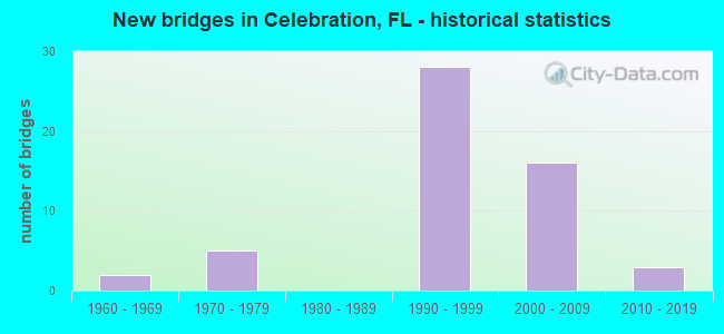
- New bridges - historical statistics
- 21960-1969
- 51970-1979
- 281990-1999
- 162000-2009
- 32010-2019

- Reconstructed bridges - Historical Statistics
- 11990-1999
- 22000-2009


- Bridge Condition - Deck
- 26.1%Very good
- 60.9%Good
- 13.0%Satisfactory

- Bridge Condition - Superstructure
- 28.0%Very good
- 64.0%Good
- 8.0%Satisfactory

- Bridge Condition - Substructure
- 24.0%Very good
- 72.0%Good
- 4.0%Satisfactory

- Bridge Condition - Channel
- 36.4%Very good
- 54.5%Good
- 9.1%Satisfactory
Find on map >> Show street view
Structure Number: 920083, Location: US-192 Ramp B - I-4 (Lat: 28.331069, Lng: -81.546919), Route carried "on" structure: Ramp US 192, Year Built: 1970, Status: Open, Structure Length: 9.57m (31.40ft), Average Daily Traffic: 17,000 (year 2020), Truck Traffic: 3%, Average Future Daily Traffic: 29,495 (year 2042), Design Load: HS 20, Features Intersected: I-4
Minimum Vertical Clearance: 30+ m (98+ ft), Kilometerpoint: 0.494, Lanes on structure: 2, Lanes under structure: 7, Owner: State Highway Agency, Approaching Roadway Width: 12.2m (40.0ft), Skew: 4 degrees, Material/Design: Prestressed concrete, Design/Construction: Stringer/Multi-beam, Number Of Spans In Main Unit: 4, Length of Maximum Span: 32.0m (105.0ft), Curb-To-Curb Width: 12.2m (40.0ft), Out-to-Out Width: 13.1m (43.0ft)
Condition: Deck: Good, Superstructure: Good, Substructure: Good, Operating Rating: 54.6 metric tons, Method Used To Determine Operating Rating: Load Factor (LF), Inventory Rating: 33.6 metric tons, Method Used To Determine Inventory Rating: Load Factor (LF), Structural Evaluation: Better than present minimum criteria, Deck Geometry: Superior to present desirable criteria, Underclear: Somewhat better than minimum adequacy, Approach Roadway Alignment: Equal to present desirable criteria, Length Of Structure Improvement: 2.59m (8.50ft), Designated Inspection Frequency: Every 24 months, Inspection Date: March 2020, Bridge Improvement Cost: $40,000, Total Project Cost: $309,000, Deck Structure Type: Concrete Cast-file-Place, Wearing Surface/Protective System: Wearing Surface: Monolithic Concrete
Find on map >> Show street view
Structure Number: 920084, Location: Leg B Ramp - US-192 (Lat: 28.332864, Lng: -81.542081), Route carried "on" structure: Ramp US 192, Year Built: 1970, Status: Open, Structure Length: 12.31m (40.39ft), Average Daily Traffic: 17,000 (year 2020), Truck Traffic: 3%, Average Future Daily Traffic: 29,495 (year 2042), Design Load: HS 20, Features Intersected: US-192, Facility Carried by Structure: Leg B Ramp to I-4
Minimum Vertical Clearance: 30+ m (98+ ft), Kilometerpoint: 1.028, Lanes on structure: 2, Lanes under structure: 6, Owner: State Highway Agency, Approaching Roadway Width: 12.5m (41.0ft), Skew: 4 degrees, Material/Design: Prestressed concrete, Design/Construction: Stringer/Multi-beam, Number Of Spans In Main Unit: 6, Length of Maximum Span: 27.4m (89.9ft), Curb-To-Curb Width: 11.9m (39.0ft), Out-to-Out Width: 12.8m (42.0ft)
Condition: Deck: Satisfactory, Superstructure: Good, Substructure: Good, Operating Rating: 56.6 metric tons, Method Used To Determine Operating Rating: Load Factor (LF), Inventory Rating: 34.9 metric tons, Method Used To Determine Inventory Rating: Load Factor (LF), Structural Evaluation: Better than present minimum criteria, Deck Geometry: Superior to present desirable criteria, Underclear: Meets minimum limits, Approach Roadway Alignment: Equal to present desirable criteria, Designated Inspection Frequency: Every 24 months, Inspection Date: March 2020, Deck Structure Type: Concrete Cast-file-Place, Wearing Surface/Protective System: Wearing Surface: Monolithic Concrete
Find on map >> Show street view
Structure Number: 920098, Location: I-4 WB - Reedy Creek (Lat: 28.298747, Lng: -81.577658), Route carried "on" structure: Interstate 4, Year Built: 1960, Year Reconstructed: 2006, Status: Open, Structure Length: 7.01m (23.00ft), Average Daily Traffic: 60,000 (year 2020), Truck Traffic: 12%, Average Future Daily Traffic: 104,100 (year 2042), Design Load: HS 20, Features Intersected: Reedy Creek
Minimum Vertical Clearance: 30+ m (98+ ft), Kilometerpoint: 5.621, Lanes on structure: 4, Base Highway Network: Yes, Owner: State Highway Agency, Approaching Roadway Width: 22.3m (73.2ft), Material/Design: Prestressed concrete, Design/Construction: Stringer/Multi-beam, Number Of Spans In Main Unit: 6, Length of Maximum Span: 11.6m (38.1ft), Curb-To-Curb Width: 23.0m (75.5ft), Out-to-Out Width: 23.9m (78.4ft)
Condition: Deck: Satisfactory, Superstructure: Good, Substructure: Good, Channel: Very good, Operating Rating: 52.3 metric tons, Method Used To Determine Operating Rating: Load Factor (LF), Inventory Rating: 32.7 metric tons, Method Used To Determine Inventory Rating: Load Factor (LF), Structural Evaluation: Better than present minimum criteria, Deck Geometry: Superior to present desirable criteria, Waterway Adequacy: Equal to present desirable criteria, Approach Roadway Alignment: Equal to present desirable criteria, Designated Inspection Frequency: Every 24 months, Underwater Inspection Frequency: Every 24 months, Inspection Date: March 2020, Underwater Inspection Date: March 2020, Deck Structure Type: Concrete Cast-file-Place, Wearing Surface/Protective System: Wearing Surface: Monolithic Concrete
Find on map >> Show street view
Structure Number: 920099, Location: I-4 EB - Reedy Creek (Lat: 28.298544, Lng: -81.577369), Route carried "on" structure: Interstate 4, Year Built: 1960, Year Reconstructed: 2006, Status: Open, Structure Length: 7.01m (23.00ft), Average Daily Traffic: 60,000 (year 2020), Truck Traffic: 12%, Average Future Daily Traffic: 104,100 (year 2042), Design Load: HS 20, Features Intersected: Reedy Creek
Minimum Vertical Clearance: 30+ m (98+ ft), Kilometerpoint: 5.621, Lanes on structure: 4, Base Highway Network: Yes, Owner: State Highway Agency, Approaching Roadway Width: 20.1m (65.9ft), Material/Design: Prestressed concrete, Design/Construction: Stringer/Multi-beam, Number Of Spans In Main Unit: 6, Length of Maximum Span: 11.6m (38.1ft), Curb-To-Curb Width: 20.7m (67.9ft), Out-to-Out Width: 21.7m (71.2ft)
Condition: Deck: Good, Superstructure: Good, Substructure: Good, Channel: Good, Operating Rating: 53.9 metric tons, Method Used To Determine Operating Rating: Load Factor (LF), Inventory Rating: 32.7 metric tons, Method Used To Determine Inventory Rating: Load Factor (LF), Structural Evaluation: Better than present minimum criteria, Deck Geometry: Equal to present minimum criteria, Waterway Adequacy: Equal to present desirable criteria, Approach Roadway Alignment: Equal to present desirable criteria, Designated Inspection Frequency: Every 24 months, Underwater Inspection Frequency: Every 24 months, Inspection Date: March 2020, Underwater Inspection Date: March 2020, Deck Structure Type: Concrete Cast-file-Place, Wearing Surface/Protective System: Wearing Surface: Bituminous
Find on map >> Show street view
Structure Number: 920156, Location: 0.56 MI S OF US 192 (Lat: 28.327953, Lng: -81.530969), Route carried "on" structure: State highway 417, Year Built: 1995, Status: Open, Structure Length: 4.54m (14.90ft), Average Daily Traffic: 13,050 (year 2020), Truck Traffic: 12%, Average Future Daily Traffic: 22,642 (year 2042), Design Load: HS 20+Mod, Features Intersected: CELEBRATION AVE
Minimum Vertical Clearance: 30+ m (98+ ft), Kilometerpoint: 1.616, Lanes on structure: 2, Lanes under structure: 7, Base Highway Network: Yes, Toll: On toll road, Owner: State Toll Authority, Approaching Roadway Width: 12.2m (40.0ft), Skew: 2 degrees, Material/Design: Steel, Design/Construction: Stringer/Multi-beam, Number Of Spans In Main Unit: 1, Length of Maximum Span: 45.4m (149.0ft), Curb-To-Curb Width: 12.2m (40.0ft), Out-to-Out Width: 13.2m (43.3ft)
Condition: Deck: Good, Superstructure: Good, Substructure: Good, Operating Rating: 63.8 metric tons, Method Used To Determine Operating Rating: Load Factor (LF), Inventory Rating: 38.3 metric tons, Method Used To Determine Inventory Rating: Load Factor (LF), Structural Evaluation: Better than present minimum criteria, Deck Geometry: Better than present minimum criteria, Underclear: Superior to present desirable criteria, Approach Roadway Alignment: Equal to present desirable criteria, Designated Inspection Frequency: Every 24 months, Inspection Date: January 2022, Deck Structure Type: Concrete Cast-file-Place
Find on map >> Show street view
Structure Number: 920157, Location: 0.56 MI S OF US 192 (Lat: 28.327689, Lng: -81.530967), Route carried "on" structure: State highway 417, Year Built: 1995, Status: Open, Structure Length: 4.54m (14.90ft), Average Daily Traffic: 13,050 (year 2020), Truck Traffic: 12%, Average Future Daily Traffic: 22,642 (year 2042), Design Load: HS 20+Mod, Features Intersected: CELEBRATION AVE
Minimum Vertical Clearance: 30+ m (98+ ft), Kilometerpoint: 1.595, Lanes on structure: 2, Lanes under structure: 7, Base Highway Network: Yes, Toll: On toll road, Owner: State Toll Authority, Approaching Roadway Width: 12.2m (40.0ft), Skew: 2 degrees, Material/Design: Steel, Design/Construction: Stringer/Multi-beam, Number Of Spans In Main Unit: 1, Length of Maximum Span: 45.4m (149.0ft), Curb-To-Curb Width: 12.2m (40.0ft), Out-to-Out Width: 13.2m (43.3ft)
Condition: Deck: Good, Superstructure: Very good, Substructure: Very good, Operating Rating: 63.8 metric tons, Method Used To Determine Operating Rating: Load Factor (LF), Inventory Rating: 38.3 metric tons, Method Used To Determine Inventory Rating: Load Factor (LF), Structural Evaluation: Equal to present desirable criteria, Deck Geometry: Better than present minimum criteria, Underclear: Superior to present desirable criteria, Approach Roadway Alignment: Equal to present desirable criteria, Designated Inspection Frequency: Every 24 months, Inspection Date: January 2022, Deck Structure Type: Concrete Cast-file-Place
Find on map >> Show street view
Structure Number: 920158, Location: .6MI N OF CELEBRATION AVE (Lat: 28.333986, Lng: -81.522150), Route carried "on" structure: State highway 417, Year Built: 1995, Status: Open, Structure Length: 37.21m (122.08ft), Average Daily Traffic: 16,650 (year 2020), Truck Traffic: 12%, Average Future Daily Traffic: 28,888 (year 2042), Design Load: HS 20+Mod, Features Intersected: US 192/I DR/BONNET CANAL
Minimum Vertical Clearance: 30+ m (98+ ft), Kilometerpoint: 2.560, Lanes on structure: 2, Lanes under structure: 13, Base Highway Network: Yes, Toll: On toll road, Owner: State Toll Authority, Approaching Roadway Width: 12.2m (40.0ft), Skew: 9 degrees, Material/Design: Steel continuous, Design/Construction: Stringer/Multi-beam, Number Of Spans In Main Unit: 10, Length of Maximum Span: 68.0m (223.1ft), Curb-To-Curb Width: 12.2m (40.0ft), Out-to-Out Width: 13.1m (43.0ft)
Condition: Deck: Good, Superstructure: Good, Substructure: Good, Channel: Very good, Operating Rating: 56.6 metric tons, Method Used To Determine Operating Rating: Load Factor (LF), Inventory Rating: 34.0 metric tons, Method Used To Determine Inventory Rating: Load Factor (LF), Structural Evaluation: Better than present minimum criteria, Deck Geometry: Better than present minimum criteria, Underclear: Equal to present minimum criteria, Waterway Adequacy: Superior to present desirable criteria, Approach Roadway Alignment: Equal to present desirable criteria, Designated Inspection Frequency: Every 24 months, Inspection Date: January 2022, Deck Structure Type: Concrete Cast-file-Place
Find on map >> Show street view
Structure Number: 920159, Location: .6 MI N OF CELEBRATION AV (Lat: 28.333872, Lng: -81.521867), Route carried "on" structure: State highway 417, Year Built: 1995, Status: Open, Structure Length: 37.20m (122.05ft), Average Daily Traffic: 16,650 (year 2020), Truck Traffic: 12%, Average Future Daily Traffic: 28,888 (year 2042), Design Load: HS 20+Mod, Features Intersected: US 192/I DR/BONNET CANAL
Minimum Vertical Clearance: 30+ m (98+ ft), Kilometerpoint: 2.575, Lanes on structure: 2, Lanes under structure: 13, Base Highway Network: Yes, Toll: On toll road, Owner: State Toll Authority, Approaching Roadway Width: 12.2m (40.0ft), Skew: 9 degrees, Material/Design: Steel continuous, Design/Construction: Stringer/Multi-beam, Number Of Spans In Main Unit: 8, Length of Maximum Span: 84.7m (277.9ft), Curb-To-Curb Width: 12.2m (40.0ft), Out-to-Out Width: 13.1m (43.0ft)
Condition: Deck: Good, Superstructure: Good, Substructure: Good, Channel: Very good, Operating Rating: 54.9 metric tons, Method Used To Determine Operating Rating: Load Factor (LF), Inventory Rating: 32.9 metric tons, Method Used To Determine Inventory Rating: Load Factor (LF), Structural Evaluation: Better than present minimum criteria, Deck Geometry: Better than present minimum criteria, Underclear: Equal to present minimum criteria, Waterway Adequacy: Superior to present desirable criteria, Approach Roadway Alignment: Equal to present desirable criteria, Designated Inspection Frequency: Every 24 months, Inspection Date: January 2022, Deck Structure Type: Concrete Cast-file-Place
Find on map >> Show street view
Structure Number: 92016, Location: 0.7 MI N OF US HWY 192 (Lat: 28.341736, Lng: -81.517353), Route carried "on" structure: State highway 417, Year Built: 1996, Status: Open, Structure Length: 4.81m (15.78ft), Average Daily Traffic: 16,650 (year 2020), Truck Traffic: 12%, Average Future Daily Traffic: 28,888 (year 2042), Design Load: HS 20+Mod, Features Intersected: OSCEOLA PKWY (CR 522)
Minimum Vertical Clearance: 30+ m (98+ ft), Kilometerpoint: 3.711, Lanes on structure: 2, Lanes under structure: 5, Base Highway Network: Yes, Toll: On toll road, Owner: State Toll Authority, Approaching Roadway Width: 12.2m (40.0ft), Material/Design: Steel, Design/Construction: Stringer/Multi-beam, Number Of Spans In Main Unit: 1, Length of Maximum Span: 48.1m (157.8ft), Curb-To-Curb Width: 12.2m (40.0ft), Out-to-Out Width: 13.1m (43.0ft)
Condition: Deck: Good, Superstructure: Good, Substructure: Good, Operating Rating: 75.2 metric tons, Method Used To Determine Operating Rating: Load Factor (LF), Inventory Rating: 45.1 metric tons, Method Used To Determine Inventory Rating: Load Factor (LF), Structural Evaluation: Better than present minimum criteria, Deck Geometry: Better than present minimum criteria, Underclear: Equal to present minimum criteria, Approach Roadway Alignment: Equal to present desirable criteria, Designated Inspection Frequency: Every 24 months, Inspection Date: January 2022, Deck Structure Type: Concrete Cast-file-Place
Find on map >> Show street view
Structure Number: 920161, Location: 0.7 MI N OF US HWY 192 (Lat: 28.341597, Lng: -81.517122), Route carried "on" structure: State highway 417, Year Built: 1996, Status: Open, Structure Length: 5.00m (16.40ft), Average Daily Traffic: 16,650 (year 2020), Truck Traffic: 12%, Average Future Daily Traffic: 28,888 (year 2042), Design Load: HS 20+Mod, Features Intersected: OSCEOLA PKWY (CR522)
Minimum Vertical Clearance: 30+ m (98+ ft), Kilometerpoint: 3.706, Lanes on structure: 2, Lanes under structure: 5, Base Highway Network: Yes, Toll: On toll road, Owner: State Toll Authority, Approaching Roadway Width: 12.2m (40.0ft), Material/Design: Steel, Design/Construction: Stringer/Multi-beam, Number Of Spans In Main Unit: 1, Length of Maximum Span: 50.0m (164.0ft), Curb-To-Curb Width: 12.2m (40.0ft), Out-to-Out Width: 13.1m (43.0ft)
Condition: Deck: Good, Superstructure: Good, Substructure: Good, Operating Rating: 66.3 metric tons, Method Used To Determine Operating Rating: Load Factor (LF), Inventory Rating: 39.8 metric tons, Method Used To Determine Inventory Rating: Load Factor (LF), Structural Evaluation: Better than present minimum criteria, Deck Geometry: Better than present minimum criteria, Underclear: Equal to present minimum criteria, Approach Roadway Alignment: Equal to present desirable criteria, Designated Inspection Frequency: Every 24 months, Inspection Date: January 2022, Deck Structure Type: Concrete Cast-file-Place
Find on map >> Show street view
Structure Number: 920162, Location: 0.7 MI N OF US HWY 192 (Lat: 28.341522, Lng: -81.516922), Route carried "on" structure: Ramp State highway 417, Year Built: 1996, Status: Open, Structure Length: 5.09m (16.70ft), Average Daily Traffic: 2,250 (year 2020), Truck Traffic: 12%, Average Future Daily Traffic: 3,904 (year 2042), Design Load: HS 20+Mod, Features Intersected: OSCEOLA PKWY (CR 522)
Minimum Vertical Clearance: 30+ m (98+ ft), Kilometerpoint: 0.364, Lanes on structure: 1, Lanes under structure: 5, Toll: On toll road, Owner: State Toll Authority, Approaching Roadway Width: 8.2m (26.9ft), Material/Design: Steel, Design/Construction: Stringer/Multi-beam, Number Of Spans In Main Unit: 1, Length of Maximum Span: 50.9m (167.0ft), Curb-To-Curb Width: 8.2m (26.9ft), Out-to-Out Width: 9.2m (30.2ft)
Condition: Deck: Good, Superstructure: Good, Substructure: Good, Operating Rating: 67.9 metric tons, Method Used To Determine Operating Rating: Load Factor (LF), Inventory Rating: 40.7 metric tons, Method Used To Determine Inventory Rating: Load Factor (LF), Structural Evaluation: Better than present minimum criteria, Deck Geometry: Superior to present desirable criteria, Underclear: Equal to present minimum criteria, Approach Roadway Alignment: Equal to present desirable criteria, Designated Inspection Frequency: Every 24 months, Inspection Date: January 2022, Deck Structure Type: Concrete Cast-file-Place
Find on map >> Show street view
Structure Number: 920169, Location: I 4 SR 400 AND SR 417 (Lat: 28.326514, Lng: -81.551472), Route carried "on" structure: Ramp State highway 417, Year Built: 1996, Status: Open, Structure Length: 19.13m (62.76ft), Average Daily Traffic: 11,000 (year 2020), Truck Traffic: 12%, Average Future Daily Traffic: 19,085 (year 2042), Design Load: HS 20+Mod, Features Intersected: INTERSTATE 4 SR 400
Minimum Vertical Clearance: 30+ m (98+ ft), Kilometerpoint: 0.290, Lanes on structure: 2, Lanes under structure: 9, Toll: On toll road, Owner: State Toll Authority, Approaching Roadway Width: 13.5m (44.3ft), Material/Design: Steel continuous, Design/Construction: Box Beam or Girders - Single/Spread, Number Of Spans In Main Unit: 4, Length of Maximum Span: 64.9m (212.9ft), Curb-To-Curb Width: 14.2m (46.6ft), Out-to-Out Width: 15.1m (49.5ft)
Condition: Deck: Very good, Superstructure: Good, Substructure: Good, Operating Rating: 49.6 metric tons, Method Used To Determine Operating Rating: Load Factor (LF), Inventory Rating: 29.8 metric tons, Method Used To Determine Inventory Rating: Load Factor (LF), Structural Evaluation: Better than present minimum criteria, Deck Geometry: Superior to present desirable criteria, Underclear: Better than present minimum criteria, Approach Roadway Alignment: Better than present minimum criteria, Designated Inspection Frequency: Every 24 months, Critical Feature Inspection Frequency: Every 24 months, Inspection Date: January 2022, Critical Feature Inspection Date: January 2022, Deck Structure Type: Concrete Cast-file-Place
Find on map >> Show street view
Structure Number: 920175, Location: US-192 over Reedy Creek (Lat: 28.332514, Lng: -81.580208), Route carried "on" structure: US 530, Year Built: 2001, Status: Open, Structure Length: 5.94m (19.49ft), Average Daily Traffic: 57,000 (year 2020), Truck Traffic: 7%, Average Future Daily Traffic: 98,895 (year 2042), Design Load: HS 25 or greater, Features Intersected: Reedy Creek, Facility Carried by Structure: US-192
Minimum Vertical Clearance: 30+ m (98+ ft), Kilometerpoint: 5.309, Lanes on structure: 6, Base Highway Network: Yes, Owner: State Highway Agency, Approaching Roadway Width: 32.4m (106.3ft), Skew: 20 degrees, Material/Design: Concrete continuous, Design/Construction: Slab, Number Of Spans In Main Unit: 6, Length of Maximum Span: 9.9m (32.5ft), Curb-To-Curb Width: 32.4m (106.3ft), Out-to-Out Width: 33.3m (109.3ft)
Condition: Deck: Satisfactory, Superstructure: Satisfactory, Substructure: Satisfactory, Channel: Good, Operating Rating: 70.5 metric tons, Method Used To Determine Operating Rating: Load Factor (LF), Inventory Rating: 42.3 metric tons, Method Used To Determine Inventory Rating: Load Factor (LF), Structural Evaluation: Equal to present minimum criteria, Deck Geometry: Superior to present desirable criteria, Waterway Adequacy: Equal to present desirable criteria, Approach Roadway Alignment: Equal to present desirable criteria, Designated Inspection Frequency: Every 24 months, Underwater Inspection Frequency: Every 24 months, Inspection Date: August 2021, Underwater Inspection Date: August 2021, Deck Structure Type: Concrete Cast-file-Place, Wearing Surface/Protective System: Wearing Surface: Monolithic Concrete
Find on map >> Show street view
Structure Number: 920192, Location: US-192 WB over I-4 (Lat: 28.332778, Lng: -81.545361), Route carried "on" structure: US 192, Year Built: 2007, Status: Open, Structure Length: 13.78m (45.21ft), Average Daily Traffic: 30,500 (year 2018), Truck Traffic: 7%, Average Future Daily Traffic: 52,918 (year 2040), Design Load: HS 20, Features Intersected: I-4
Minimum Vertical Clearance: 30+ m (98+ ft), Kilometerpoint: 8.686, Lanes on structure: 3, Lanes under structure: 9, Base Highway Network: Yes, Owner: State Highway Agency, Approaching Roadway Width: 15.8m (51.8ft), Skew: 4 degrees, Material/Design: Steel continuous, Design/Construction: Stringer/Multi-beam, Number Of Spans In Main Unit: 2, Length of Maximum Span: 71.2m (233.6ft), Curb-To-Curb Width: 16.2m (53.1ft), Out-to-Out Width: 17.1m (56.1ft)
Condition: Deck: Very good, Superstructure: Very good, Substructure: Very good, Operating Rating: 58.2 metric tons, Method Used To Determine Operating Rating: Load Factor (LF), Inventory Rating: 34.8 metric tons, Method Used To Determine Inventory Rating: Load Factor (LF), Structural Evaluation: Equal to present desirable criteria, Deck Geometry: Better than present minimum criteria, Underclear: Equal to present minimum criteria, Approach Roadway Alignment: Equal to present desirable criteria, Designated Inspection Frequency: Every 24 months, Inspection Date: January 2021, Deck Structure Type: Concrete Cast-file-Place, Wearing Surface/Protective System: Wearing Surface: Monolithic Concrete
Find on map >> Show street view
Structure Number: 920193, Location: US-192 EB over I-4 (Lat: 28.332500, Lng: -81.545833), Route carried "on" structure: US 192, Year Built: 2006, Status: Open, Structure Length: 13.62m (44.69ft), Average Daily Traffic: 30,500 (year 2018), Truck Traffic: 7%, Average Future Daily Traffic: 52,918 (year 2040), Design Load: HS 20, Features Intersected: I-4
Minimum Vertical Clearance: 30+ m (98+ ft), Kilometerpoint: 8.657, Lanes on structure: 4, Lanes under structure: 9, Base Highway Network: Yes, Owner: State Highway Agency, Approaching Roadway Width: 19.5m (64.0ft), Skew: 4 degrees, Material/Design: Steel continuous, Design/Construction: Stringer/Multi-beam, Number Of Spans In Main Unit: 2, Length of Maximum Span: 71.4m (234.3ft), Curb-To-Curb Width: 19.5m (64.0ft), Out-to-Out Width: 20.5m (67.3ft)
Condition: Deck: Very good, Superstructure: Very good, Substructure: Very good, Operating Rating: 55.5 metric tons, Method Used To Determine Operating Rating: Load Factor (LF), Inventory Rating: 33.0 metric tons, Method Used To Determine Inventory Rating: Load Factor (LF), Structural Evaluation: Equal to present desirable criteria, Deck Geometry: Better than present minimum criteria, Underclear: Equal to present minimum criteria, Approach Roadway Alignment: Equal to present desirable criteria, Designated Inspection Frequency: Every 24 months, Inspection Date: January 2021, Deck Structure Type: Concrete Cast-file-Place, Wearing Surface/Protective System: Wearing Surface: Monolithic Concrete
Find on map >> Show street view
Structure Number: 920194, Location: Ramp BD over I-4 (Lat: 28.333417, Lng: -81.544603), Route carried "on" structure: US 530, Year Built: 2006, Status: Open, Structure Length: 11.57m (37.96ft), Average Daily Traffic: 700 (year 2018), Truck Traffic: 10%, Average Future Daily Traffic: 1,214 (year 2040), Design Load: HS 20, Features Intersected: I-4, Facility Carried by Structure: Ramp BD over I-4
Minimum Vertical Clearance: 30+ m (98+ ft), Kilometerpoint: 1.049, Lanes on structure: 1, Lanes under structure: 9, Base Highway Network: Yes, Owner: State Highway Agency, Approaching Roadway Width: 10.1m (33.1ft), Material/Design: Steel continuous, Design/Construction: Stringer/Multi-beam, Number Of Spans In Main Unit: 2, Length of Maximum Span: 60.2m (197.5ft), Curb-To-Curb Width: 10.1m (33.1ft), Out-to-Out Width: 10.1m (33.1ft)
Condition: Deck: Good, Superstructure: Good, Substructure: Good, Operating Rating: 59.1 metric tons, Method Used To Determine Operating Rating: Load Factor (LF), Inventory Rating: 35.6 metric tons, Method Used To Determine Inventory Rating: Load Factor (LF), Structural Evaluation: Better than present minimum criteria, Deck Geometry: Equal to present minimum criteria, Underclear: Equal to present minimum criteria, Approach Roadway Alignment: Equal to present desirable criteria, Designated Inspection Frequency: Every 24 months, Inspection Date: January 2021, Deck Structure Type: Concrete Cast-file-Place, Wearing Surface/Protective System: Wearing Surface: Monolithic Concrete
Find on map >> Show street view
Structure Number: 920195, Location: 1.3MI W OF 417 (Lat: 28.333056, Lng: -81.546389), Route carried "on" structure: Ramp Interstate 192, Year Built: 2007, Status: Open, Structure Length: 51.15m (167.81ft), Average Daily Traffic: 4,200 (year 2018), Truck Traffic: 4%, Average Future Daily Traffic: 7,287 (year 2040), Design Load: HS 20, Features Intersected: I-4
Minimum Vertical Clearance: 30+ m (98+ ft), Kilometerpoint: 0.056, Lanes on structure: 1, Lanes under structure: 16, Base Highway Network: Yes, Owner: State Highway Agency, Approaching Roadway Width: 10.4m (34.1ft), Skew: 1 degrees, Material/Design: Steel continuous, Design/Construction: Box Beam or Girders - Single/Spread, Number Of Spans In Main Unit: 9, Length of Maximum Span: 65.8m (215.9ft), Curb-To-Curb Width: 11.2m (36.7ft), Out-to-Out Width: 11.2m (36.7ft)
Condition: Deck: Very good, Superstructure: Very good, Substructure: Good, Operating Rating: 55.5 metric tons, Method Used To Determine Operating Rating: Load Factor (LF), Inventory Rating: 33.3 metric tons, Method Used To Determine Inventory Rating: Load Factor (LF), Structural Evaluation: Better than present minimum criteria, Deck Geometry: Superior to present desirable criteria, Underclear: Equal to present minimum criteria, Approach Roadway Alignment: Equal to present desirable criteria, Designated Inspection Frequency: Every 24 months, Critical Feature Inspection Frequency: Every 24 months, Inspection Date: Febuary 2021, Critical Feature Inspection Date: Febuary 2021, Deck Structure Type: Concrete Cast-file-Place, Wearing Surface/Protective System: Wearing Surface: Monolithic Concrete
Find on map >> Show street view
Structure Number: 920201, Location: US-192 WBRmp-World Dr Rmp (Lat: 28.338014, Lng: -81.567078), Route carried "on" structure: Ramp State highway 192, Year Built: 1996, Status: Open, Structure Length: 23.44m (76.90ft), Average Daily Traffic: 6,900 (year 2020), Truck Traffic: 6%, Average Future Daily Traffic: 11,972 (year 2042), Design Load: HL 93, Features Intersected: World Drive Ramp
Minimum Vertical Clearance: 30+ m (98+ ft), Kilometerpoint: 0.834, Lanes on structure: 2, Lanes under structure: 1, Owner: State Highway Agency, Approaching Roadway Width: 12.1m (39.7ft), Material/Design: Steel continuous, Design/Construction: Stringer/Multi-beam, Number Of Spans In Main Unit: 3, Number Of Approach Spans: 4, Length of Maximum Span: 55.8m (183.1ft), Curb-To-Curb Width: 12.2m (40.0ft), Out-to-Out Width: 13.1m (43.0ft)
Condition: Deck: Good, Superstructure: Good, Substructure: Good, Operating Rating: 36.6 metric tons, Method Used To Determine Operating Rating: Load and Resistance Factor (LRFR), Inventory Rating: 28.1 metric tons, Method Used To Determine Inventory Rating: Load and Resistance Factor (LRFR), Structural Evaluation: Better than present minimum criteria, Deck Geometry: Superior to present desirable criteria, Underclear: Equal to present minimum criteria, Approach Roadway Alignment: Equal to present desirable criteria, Designated Inspection Frequency: Every 24 months, Critical Feature Inspection Frequency: Every 24 months, Inspection Date: Febuary 2021, Critical Feature Inspection Date: Febuary 2021, Deck Structure Type: Concrete Cast-file-Place, Wearing Surface/Protective System: Wearing Surface: Monolithic Concrete
Find on map >> Show street view
Structure Number: 920205, Location: I-4/US 530 Interchange (Lat: 28.336547, Lng: -81.540914), Route carried "on" structure: Ramp Other road , Year Built: 2013, Status: Open, Structure Length: 12.27m (40.26ft), Average Daily Traffic: 1,800 (year 2020), Truck Traffic: 6%, Average Future Daily Traffic: 3,123 (year 2042), Design Load: HL 93, Features Intersected: Ramps AC & C1, Facility Carried by Structure: Ramp C
Minimum Vertical Clearance: 30+ m (98+ ft), Kilometerpoint: 0.375, Lanes on structure: 1, Lanes under structure: 2, Owner: State Highway Agency, Approaching Roadway Width: 8.1m (26.6ft), Material/Design: Steel, Design/Construction: Stringer/Multi-beam, Number Of Spans In Main Unit: 2, Length of Maximum Span: 61.0m (200.1ft), Curb-To-Curb Width: 8.1m (26.6ft), Out-to-Out Width: 9.2m (30.2ft)
Condition: Deck: Very good, Superstructure: Very good, Substructure: Very good, Operating Rating: 46.4 metric tons, Method Used To Determine Operating Rating: Load and Resistance Factor (LRFR), Inventory Rating: 35.9 metric tons, Method Used To Determine Inventory Rating: Load and Resistance Factor (LRFR), Structural Evaluation: Equal to present desirable criteria, Deck Geometry: Superior to present desirable criteria, Underclear: Somewhat better than minimum adequacy, Approach Roadway Alignment: Equal to present desirable criteria, Designated Inspection Frequency: Every 24 months, Critical Feature Inspection Frequency: Every 24 months, Inspection Date: October 2021, Critical Feature Inspection Date: October 2021, Deck Structure Type: Concrete Cast-file-Place, Wearing Surface/Protective System: Wearing Surface: Monolithic Concrete
Find on map >> Show street view
Structure Number: 9206, Location: .2MI S OF CELEBRATION AVE (Lat: 28.326747, Lng: -81.535686), Route carried "on" structure: State highway 417, Year Built: 1995, Status: Open, Structure Length: 1.24m (4.07ft), Average Daily Traffic: 26,100 (year 2020), Truck Traffic: 12%, Average Future Daily Traffic: 45,284 (year 2042), Design Load: HS 20+Mod, Features Intersected: C 2 CANAL
Minimum Vertical Clearance: 30+ m (98+ ft), Kilometerpoint: 1.138, Lanes on structure: 6, Base Highway Network: Yes, Toll: On toll road, Owner: State Toll Authority, Approaching Roadway Width: 39.8m (130.6ft), Skew: 13 degrees, Material/Design: Concrete, Design/Construction: Culvert, Number Of Spans In Main Unit: 4, Length of Maximum Span: 2.8m (9.2ft)
Condition: Channel: Satisfactory, Culverts: Good, Operating Rating: 50.1 metric tons, Method Used To Determine Operating Rating: Load Factor (LF), Inventory Rating: 30.0 metric tons, Method Used To Determine Inventory Rating: Load Factor (LF), Structural Evaluation: Better than present minimum criteria, Waterway Adequacy: Superior to present desirable criteria, Approach Roadway Alignment: Equal to present desirable criteria, Designated Inspection Frequency: Every 24 months, Inspection Date: January 2022
Find on map >> Show street view
Structure Number: 924159, Location: 0.8 Mi. West of SR-535 (Lat: 28.339553, Lng: -81.495869), Route carried "on" structure: County highway 522, Year Built: 1995, Status: Open, Structure Length: 3.74m (12.27ft), Average Daily Traffic: 38,000 (year 2020), Truck Traffic: 4%, Average Future Daily Traffic: 65,930 (year 2042), Design Load: HS 20, Features Intersected: Polynesian Isle Blvd, Facility Carried by Structure: Osceola Parkway
Minimum Vertical Clearance: 30+ m (98+ ft), Kilometerpoint: 5.564, Lanes on structure: 4, Lanes under structure: 3, Base Highway Network: Yes, Toll: On toll road, Owner: County Highway Agency, Approaching Roadway Width: 17.1m (56.1ft), Skew: 22 degrees, Material/Design: Prestressed concrete, Design/Construction: Stringer/Multi-beam, Number Of Spans In Main Unit: 1, Length of Maximum Span: 36.8m (120.7ft), Curb or Sidewalk Widths: Left: 2.0m (6.6ft), Right: 2.0m (6.6ft), Curb-To-Curb Width: 25.1m (82.3ft), Out-to-Out Width: 35.7m (117.1ft)
Condition: Deck: Good, Superstructure: Good, Substructure: Good, Inventory Rating: 60.2 metric tons, Method Used To Determine Inventory Rating: Load Factor (LF), Structural Evaluation: Better than present minimum criteria, Deck Geometry: Superior to present desirable criteria, Underclear: Equal to present minimum criteria, Approach Roadway Alignment: Equal to present desirable criteria, Designated Inspection Frequency: Every 24 months, Inspection Date: July 2020, Deck Structure Type: Concrete Cast-file-Place, Wearing Surface/Protective System: Wearing Surface: Monolithic Concrete
Find on map >> Show street view
Structure Number: 924168, Location: 0.7 Mi. West of US-192 (Lat: 28.323639, Lng: -81.533806), Route carried "on" structure: County highway , Year Built: 1995, Status: Open, Structure Length: 5.55m (18.21ft), Average Daily Traffic: 19,795 (year 2020), Truck Traffic: 5%, Average Future Daily Traffic: 34,344 (year 2042), Design Load: HS 20, Features Intersected: C-2 Canal, Facility Carried by Structure: Celebration Avenue
Minimum Vertical Clearance: 30+ m (98+ ft), Kilometerpoint: 0.002, Lanes on structure: 3, Owner: County Highway Agency, Approaching Roadway Width: 11.0m (36.1ft), Skew: 2 degrees, Material/Design: Prestressed concrete, Design/Construction: Stringer/Multi-beam, Number Of Spans In Main Unit: 3, Length of Maximum Span: 18.3m (60.0ft), Curb or Sidewalk Widths: Left: 2.1m (6.9ft), Right: 2.1m (6.9ft), Curb-To-Curb Width: 11.0m (36.1ft), Out-to-Out Width: 16.2m (53.1ft)
Condition: Deck: Good, Superstructure: Very good, Substructure: Good, Channel: Good, Operating Rating: 72.6 metric tons, Method Used To Determine Operating Rating: Load Factor (LF), Inventory Rating: 41.2 metric tons, Method Used To Determine Inventory Rating: Load Factor (LF), Structural Evaluation: Better than present minimum criteria, Deck Geometry: High priority of replacement, Waterway Adequacy: Superior to present desirable criteria, Approach Roadway Alignment: Equal to present desirable criteria, Designated Inspection Frequency: Every 24 months, Inspection Date: July 2020, Deck Structure Type: Concrete Cast-file-Place, Wearing Surface/Protective System: Wearing Surface: Monolithic Concrete
Find on map >> Show street view
Structure Number: 924169, Location: 0.5 Mi. W of Celebra. Ave (Lat: 28.329667, Lng: -81.538219), Route carried "on" structure: City street , Year Built: 1994, Year Reconstructed: 2001, Status: Open, Structure Length: 4.99m (16.37ft), Average Daily Traffic: 14,700 (year 2020), Truck Traffic: 2%, Average Future Daily Traffic: 25,505 (year 2042), Design Load: HS 20, Features Intersected: C-2 Canal, Facility Carried by Structure: Celebration Place
Minimum Vertical Clearance: 30+ m (98+ ft), Kilometerpoint: 1.164, Lanes on structure: 4, Owner: County Highway Agency, Approaching Roadway Width: 16.3m (53.5ft), Skew: 25 degrees, Material/Design: Prestressed concrete, Design/Construction: Stringer/Multi-beam, Number Of Spans In Main Unit: 3, Length of Maximum Span: 16.6m (54.5ft), Curb or Sidewalk Widths: Left: 3.0m (9.8ft), Right: 3.0m (9.8ft), Curb-To-Curb Width: 16.3m (53.5ft), Out-to-Out Width: 29.1m (95.5ft)
Condition: Deck: Good, Superstructure: Satisfactory, Substructure: Good, Channel: Very good, Operating Rating: 33.6 metric tons, Method Used To Determine Operating Rating: Load Factor (LF), Inventory Rating: 20.0 metric tons, Method Used To Determine Inventory Rating: Load Factor (LF), Structural Evaluation: Somewhat better than minimum adequacy, Deck Geometry: High priority of corrective action, Waterway Adequacy: Superior to present desirable criteria, Approach Roadway Alignment: Equal to present desirable criteria, Designated Inspection Frequency: Every 24 months, Inspection Date: June 2021, Deck Structure Type: Concrete Cast-file-Place
Find on map >> Show street view
Structure Number: 924173, Location: 20ft. E of Water Street (Lat: 28.320167, Lng: -81.541222), Route carried "on" structure: County highway , Year Built: 1997, Status: Open, Structure Length: 0.91m (2.99ft), Average Daily Traffic: 135 (year 2020), Truck Traffic: 1%, Average Future Daily Traffic: 241 (year 2042), Design Load: HS 20, Features Intersected: Canal, Facility Carried by Structure: Mulberry Avenue
Minimum Vertical Clearance: 30+ m (98+ ft), Kilometerpoint: 0.016, Lanes on structure: 2, Owner: County Highway Agency, Approaching Roadway Width: 8.4m (27.6ft), Material/Design: Concrete, Design/Construction: Arch - Deck, Number Of Spans In Main Unit: 1, Length of Maximum Span: 9.1m (29.9ft), Curb or Sidewalk Widths: Left: 2.0m (6.6ft), Right: 1.5m (4.9ft), Curb-To-Curb Width: 8.4m (27.6ft), Out-to-Out Width: 13.1m (43.0ft)
Condition: Superstructure: Good, Substructure: Very good, Channel: Good, Operating Rating: 48.1 metric tons, Method Used To Determine Operating Rating: Load Factor (LF), Inventory Rating: 28.8 metric tons, Method Used To Determine Inventory Rating: Load Factor (LF), Structural Evaluation: Better than present minimum criteria, Deck Geometry: Somewhat better than minimum adequacy, Waterway Adequacy: Equal to present desirable criteria, Approach Roadway Alignment: Equal to present desirable criteria, Designated Inspection Frequency: Every 24 months, Underwater Inspection Frequency: Every 24 months, Inspection Date: July 2020, Underwater Inspection Date: July 2020
Find on map >> Show street view
Structure Number: 924174, Location: 20ft. E of Water Street (Lat: 28.322003, Lng: -81.541814), Route carried "on" structure: County highway , Year Built: 1997, Status: Open, Structure Length: 0.91m (2.99ft), Average Daily Traffic: 135 (year 2020), Truck Traffic: 2%, Average Future Daily Traffic: 235 (year 2042), Design Load: HS 20, Features Intersected: Canal, Facility Carried by Structure: Honeysuckle Avenue
Minimum Vertical Clearance: 30+ m (98+ ft), Kilometerpoint: 0.016, Lanes on structure: 2, Owner: County Highway Agency, Approaching Roadway Width: 8.4m (27.6ft), Material/Design: Concrete, Design/Construction: Arch - Deck, Number Of Spans In Main Unit: 1, Length of Maximum Span: 9.1m (29.9ft), Curb or Sidewalk Widths: Left: 1.5m (4.9ft), Right: 2.0m (6.6ft), Curb-To-Curb Width: 8.4m (27.6ft), Out-to-Out Width: 13.1m (43.0ft)
Condition: Superstructure: Good, Substructure: Very good, Channel: Good, Operating Rating: 48.1 metric tons, Method Used To Determine Operating Rating: Load Factor (LF), Inventory Rating: 28.8 metric tons, Method Used To Determine Inventory Rating: Load Factor (LF), Structural Evaluation: Better than present minimum criteria, Deck Geometry: Somewhat better than minimum adequacy, Waterway Adequacy: Equal to present desirable criteria, Approach Roadway Alignment: Equal to present desirable criteria, Designated Inspection Frequency: Every 24 months, Underwater Inspection Frequency: Every 24 months, Inspection Date: July 2020, Underwater Inspection Date: July 2020
Find on map >> Show street view
Structure Number: 92421, Location: Celebration Blvd-Reedy Cr (Lat: 28.297722, Lng: -81.576708), Route carried "on" structure: County highway , Year Built: 2019, Status: Open, Structure Length: 10.67m (35.01ft), Average Daily Traffic: 201 (year 2021), Truck Traffic: 5%, Average Future Daily Traffic: 401 (year 2042), Design Load: HL 93, Features Intersected: Reedy Creek, Facility Carried by Structure: Celebration Blvd
Minimum Vertical Clearance: 4.91m (16.11ft), Kilometerpoint: 0.000, Lanes on structure: 2, Base Highway Network: Yes, Owner: County Highway Agency, Approaching Roadway Width: 9.8m (32.2ft), Material/Design: Prestressed concrete, Design/Construction: Stringer/Multi-beam, Number Of Spans In Main Unit: 5, Length of Maximum Span: 21.3m (69.9ft), Curb or Sidewalk Widths: Left: 3.5m (11.5ft), Right: 0.9m (3.0ft), Curb-To-Curb Width: 9.8m (32.2ft), Out-to-Out Width: 14.2m (46.6ft)
Condition: Deck: Very good, Superstructure: Very good, Substructure: Good, Channel: Good, Operating Rating: 49.6 metric tons, Method Used To Determine Operating Rating: Load and Resistance Factor (LRFR), Inventory Rating: 38.6 metric tons, Method Used To Determine Inventory Rating: Load and Resistance Factor (LRFR), Structural Evaluation: Better than present minimum criteria, Deck Geometry: Better than present minimum criteria, Waterway Adequacy: Equal to present desirable criteria, Approach Roadway Alignment: Better than present minimum criteria, Designated Inspection Frequency: Every 24 months, Inspection Date: October 2021, Deck Structure Type: Concrete Cast-file-Place
Find on map >> Show street view
Structure Number: 920083, Location: US-192 Ramp B - I-4 (Lat: 28.331069, Lng: -81.546919), Route carried "under" structure: Interstate 400, Year Built: 1970, Structure Length: 0. m, Average Daily Traffic: 74,000 (year 2020), Truck Traffic: 12%, Features Intersected: I-4, Facility Carried by Structure: US-192 Ramp "B"
Minimum Vertical Clearance: 5.09m (16.70ft), Kilometerpoint: 10.354, Lanes on structure: 2, Lanes under structure: 6, Material/Design: Prestressed concrete, Design/Construction: Stringer/Multi-beam, Length of Maximum Span: 32.0m (105.0ft)
Find on map >> Show street view
Structure Number: 920083, Location: US-192 Ramp B - I-4 (Lat: 28.331069, Lng: -81.546919), Route carried "under" structure: Ramp Interstate 400, Year Built: 1970, Structure Length: 0. m, Average Daily Traffic: 5,000 (year 2020), Truck Traffic: 10%, Features Intersected: I-4, Facility Carried by Structure: US-192 Ramp "B"
Minimum Vertical Clearance: 5.15m (16.90ft), Kilometerpoint: 10.266, Lanes on structure: 2, Lanes under structure: 1, Material/Design: Prestressed concrete, Design/Construction: Stringer/Multi-beam, Length of Maximum Span: 32.0m (105.0ft)
Find on map >> Show street view
Structure Number: 920084, Location: Leg B Ramp - US-192 (Lat: 28.332864, Lng: -81.542081), Route carried "under" structure: US 192, Year Built: 1970, Structure Length: 0. m, Average Daily Traffic: 59,000 (year 2020), Truck Traffic: 5%, Features Intersected: US-192, Facility Carried by Structure: Leg B Ramp to I-4
Minimum Vertical Clearance: 6.55m (21.49ft), Kilometerpoint: 9.040, Lanes on structure: 2, Lanes under structure: 6, Material/Design: Prestressed concrete, Design/Construction: Stringer/Multi-beam, Length of Maximum Span: 27.4m (89.9ft)
Find on map >> Show street view
Structure Number: 920156, Location: 0.56 MI S OF US 192 (Lat: 28.327953, Lng: -81.530969), Route carried "under" structure: City street , Year Built: 1995, Structure Length: 0. m, Average Daily Traffic: 13,050 (year 2020), Truck Traffic: 12%, Features Intersected: CELEBRATION AVE, Facility Carried by Structure: SR 417 SB SCE 2.07
Minimum Vertical Clearance: 5.15m (16.90ft), Kilometerpoint: 1.606, Lanes on structure: 2, Lanes under structure: 7, Material/Design: Steel, Design/Construction: Stringer/Multi-beam, Length of Maximum Span: 45.4m (149.0ft)
Find on map >> Show street view
Structure Number: 920157, Location: 0.56 MI S OF US 192 (Lat: 28.327689, Lng: -81.530967), Route carried "under" structure: City street , Year Built: 1995, Structure Length: 0. m, Average Daily Traffic: 13,050 (year 2020), Truck Traffic: 12%, Features Intersected: CELEBRATION AVE, Facility Carried by Structure: SR 417 NB SCE 2.05
Minimum Vertical Clearance: 5.61m (18.41ft), Kilometerpoint: 1.606, Lanes on structure: 2, Lanes under structure: 7, Material/Design: Steel, Design/Construction: Stringer/Multi-beam, Length of Maximum Span: 45.4m (149.0ft)
Find on map >> Show street view
Structure Number: 920158, Location: .6MI N OF CELEBRATION AVE (Lat: 28.333986, Lng: -81.522150), Route carried "under" structure: US 192, Year Built: 1995, Structure Length: 0. m, Average Daily Traffic: 59,000 (year 2020), Truck Traffic: 5%, Features Intersected: US 192/I DR/BONNET CANAL, Facility Carried by Structure: SR 417 SB SCE 2.7
Minimum Vertical Clearance: 6.46m (21.19ft), Kilometerpoint: 10.915, Lanes on structure: 2, Lanes under structure: 6, Material/Design: Steel continuous, Design/Construction: Stringer/Multi-beam, Length of Maximum Span: 68.0m (223.1ft)
Find on map >> Show street view
Structure Number: 920158, Location: .6MI N OF CELEBRATION AVE (Lat: 28.333986, Lng: -81.522150), Route carried "under" structure: City street , Year Built: 1995, Structure Length: 0. m, Average Daily Traffic: 14,950 (year 2016), Truck Traffic: 15%, Features Intersected: US 192/I DR/BONNET CANAL, Facility Carried by Structure: SR 417 SB SCE 2.7
Minimum Vertical Clearance: 5.43m (17.81ft), Kilometerpoint: 2.540, Lanes on structure: 2, Lanes under structure: 7, Material/Design: Steel continuous, Design/Construction: Stringer/Multi-beam, Length of Maximum Span: 68.0m (223.1ft)
Find on map >> Show street view
Structure Number: 920159, Location: .6 MI N OF CELEBRATION AV (Lat: 28.333872, Lng: -81.521867), Route carried "under" structure: City street , Year Built: 1995, Structure Length: 0. m, Average Daily Traffic: 14,950 (year 2016), Truck Traffic: 15%, Features Intersected: US 192/I DR/BONNET CANAL, Facility Carried by Structure: SR 417 NB SCE 2.7
Minimum Vertical Clearance: 6.00m (19.69ft), Kilometerpoint: 2.573, Lanes on structure: 2, Lanes under structure: 7, Material/Design: Steel continuous, Design/Construction: Stringer/Multi-beam, Length of Maximum Span: 84.7m (277.9ft)
Find on map >> Show street view
Structure Number: 920159, Location: .6 MI N OF CELEBRATION AV (Lat: 28.333872, Lng: -81.521867), Route carried "under" structure: US 192, Year Built: 1995, Structure Length: 0. m, Average Daily Traffic: 59,000 (year 2020), Truck Traffic: 5%, Features Intersected: US 192/I DR/BONNET CANAL, Facility Carried by Structure: SR 417 NB SCE 2.7
Minimum Vertical Clearance: 7.18m (23.56ft), Kilometerpoint: 10.953, Lanes on structure: 2, Lanes under structure: 6, Material/Design: Steel continuous, Design/Construction: Stringer/Multi-beam, Length of Maximum Span: 84.7m (277.9ft)
Find on map >> Show street view
Structure Number: 92016, Location: 0.7 MI N OF US HWY 192 (Lat: 28.341736, Lng: -81.517353), Route carried "under" structure: County highway 522, Year Built: 1996, Structure Length: 0. m, Average Daily Traffic: 35,000 (year 2020), Truck Traffic: 5%, Features Intersected: OSCEOLA PKWY (CR 522), Facility Carried by Structure: SR 417 SB SCE 3.4
Minimum Vertical Clearance: 6.02m (19.75ft), Kilometerpoint: 3.283, Lanes on structure: 2, Lanes under structure: 5, Material/Design: Steel, Design/Construction: Stringer/Multi-beam, Length of Maximum Span: 48.1m (157.8ft)
Find on map >> Show street view
Structure Number: 920161, Location: 0.7 MI N OF US HWY 192 (Lat: 28.341597, Lng: -81.517122), Route carried "under" structure: County highway 522, Year Built: 1996, Structure Length: 0. m, Average Daily Traffic: 35,000 (year 2020), Truck Traffic: 5%, Features Intersected: OSCEOLA PKWY (CR522), Facility Carried by Structure: SR 417 NB SCE 3.4
Minimum Vertical Clearance: 5.21m (17.09ft), Kilometerpoint: 3.309, Lanes on structure: 2, Lanes under structure: 4, Material/Design: Steel, Design/Construction: Stringer/Multi-beam, Length of Maximum Span: 50.0m (164.0ft)
Find on map >> Show street view
Structure Number: 920162, Location: 0.7 MI N OF US HWY 192 (Lat: 28.341522, Lng: -81.516922), Route carried "under" structure: County highway 522, Year Built: 1996, Structure Length: 0. m, Average Daily Traffic: 35,000 (year 2020), Truck Traffic: 5%, Features Intersected: OSCEOLA PKWY (CR 522), Facility Carried by Structure: SR 417 NB SCE 3.4
Minimum Vertical Clearance: 4.91m (16.11ft), Kilometerpoint: 3.335, Lanes on structure: 1, Lanes under structure: 4, Material/Design: Steel, Design/Construction: Stringer/Multi-beam, Length of Maximum Span: 50.9m (167.0ft)
Find on map >> Show street view
Structure Number: 920169, Location: I 4 SR 400 AND SR 417 (Lat: 28.326514, Lng: -81.551472), Route carried "under" structure: Interstate 400, Year Built: 1996, Structure Length: 0. m, Average Daily Traffic: 74,000 (year 2020), Truck Traffic: 12%, Features Intersected: INTERSTATE 4 SR 400, Facility Carried by Structure: SR 417 SB SCE 0.4
Minimum Vertical Clearance: 6.20m (20.34ft), Kilometerpoint: 9.682, Lanes on structure: 2, Lanes under structure: 8, Material/Design: Steel continuous, Design/Construction: Box Beam or Girders - Single/Spread, Length of Maximum Span: 64.9m (212.9ft)
Find on map >> Show street view
Structure Number: 920169, Location: I 4 SR 400 AND SR 417 (Lat: 28.326514, Lng: -81.551472), Route carried "under" structure: Ramp US 192, Year Built: 1996, Structure Length: 0. m, Average Daily Traffic: 1,100 (year 2016), Truck Traffic: 17%, Features Intersected: INTERSTATE 4 SR 400, Facility Carried by Structure: SR 417 SB SCE 0.4
Minimum Vertical Clearance: 6.10m (20.01ft), Kilometerpoint: 8.328, Lanes on structure: 2, Lanes under structure: 1, Material/Design: Steel continuous, Design/Construction: Box Beam or Girders - Single/Spread, Length of Maximum Span: 64.9m (212.9ft)
Find on map >> Show street view
Structure Number: 920192, Location: US-192 WB over I-4 (Lat: 28.332778, Lng: -81.545361), Route carried "under" structure: Interstate 4, Year Built: 2007, Structure Length: 0. m, Average Daily Traffic: 84,000 (year 2018), Truck Traffic: 14%, Features Intersected: I-4, Facility Carried by Structure: US-192 WB
Minimum Vertical Clearance: 6.13m (20.11ft), Kilometerpoint: 10.596, Lanes on structure: 3, Lanes under structure: 7, Material/Design: Steel continuous, Design/Construction: Stringer/Multi-beam, Length of Maximum Span: 71.2m (233.6ft)
Find on map >> Show street view
Structure Number: 920192, Location: US-192 WB over I-4 (Lat: 28.332778, Lng: -81.545361), Route carried "under" structure: Ramp Interstate 4, Year Built: 2007, Structure Length: 0. m, Average Daily Traffic: 84,000 (year 2018), Truck Traffic: 14%, Features Intersected: I-4, Facility Carried by Structure: US-192 WB
Minimum Vertical Clearance: 5.79m (19.00ft), Kilometerpoint: 10.588, Lanes on structure: 3, Lanes under structure: 1, Material/Design: Steel continuous, Design/Construction: Stringer/Multi-beam, Length of Maximum Span: 71.2m (233.6ft)
Find on map >> Show street view
Structure Number: 920192, Location: US-192 WB over I-4 (Lat: 28.332778, Lng: -81.545361), Route carried "under" structure: Ramp Interstate 4, Year Built: 2007, Structure Length: 0. m, Average Daily Traffic: 84,000 (year 2018), Truck Traffic: 14%, Features Intersected: I-4, Facility Carried by Structure: US-192 WB
Minimum Vertical Clearance: 5.64m (18.50ft), Kilometerpoint: 10.588, Lanes on structure: 3, Lanes under structure: 1, Material/Design: Steel continuous, Design/Construction: Stringer/Multi-beam, Length of Maximum Span: 71.2m (233.6ft)
Find on map >> Show street view
Structure Number: 920193, Location: US-192 EB over I-4 (Lat: 28.332500, Lng: -81.545833), Route carried "under" structure: State highway 4, Year Built: 2006, Structure Length: 0. m, Average Daily Traffic: 84,000 (year 2018), Truck Traffic: 14%, Features Intersected: I-4, Facility Carried by Structure: US-192 EB
Minimum Vertical Clearance: 6.10m (20.01ft), Kilometerpoint: 10.540, Lanes on structure: 4, Lanes under structure: 7, Material/Design: Steel continuous, Design/Construction: Stringer/Multi-beam, Length of Maximum Span: 71.4m (234.3ft)
Find on map >> Show street view
Structure Number: 920193, Location: US-192 EB over I-4 (Lat: 28.332500, Lng: -81.545833), Route carried "under" structure: Ramp Interstate 4, Year Built: 2006, Structure Length: 0. m, Average Daily Traffic: 84,000 (year 2018), Truck Traffic: 14%, Features Intersected: I-4, Facility Carried by Structure: US-192 EB
Minimum Vertical Clearance: 5.82m (19.09ft), Kilometerpoint: 10.588, Lanes on structure: 4, Lanes under structure: 1, Material/Design: Steel continuous, Design/Construction: Stringer/Multi-beam, Length of Maximum Span: 71.4m (234.3ft)
Find on map >> Show street view
Structure Number: 920193, Location: US-192 EB over I-4 (Lat: 28.332500, Lng: -81.545833), Route carried "under" structure: Ramp Interstate 4, Year Built: 2006, Structure Length: 0. m, Average Daily Traffic: 84,000 (year 2018), Truck Traffic: 14%, Features Intersected: I-4, Facility Carried by Structure: US-192 EB
Minimum Vertical Clearance: 5.58m (18.31ft), Kilometerpoint: 10.588, Lanes on structure: 4, Lanes under structure: 1, Material/Design: Steel continuous, Design/Construction: Stringer/Multi-beam, Length of Maximum Span: 71.4m (234.3ft)
Find on map >> Show street view
Structure Number: 920194, Location: Ramp BD over I-4 (Lat: 28.333417, Lng: -81.544603), Route carried "under" structure: Ramp Interstate 4, Year Built: 2006, Structure Length: 0. m, Average Daily Traffic: 700 (year 2018), Truck Traffic: 10%, Features Intersected: I-4
Minimum Vertical Clearance: 5.33m (17.49ft), Kilometerpoint: 0.517, Lanes on structure: 1, Lanes under structure: 1, Material/Design: Steel continuous, Design/Construction: Stringer/Multi-beam, Length of Maximum Span: 60.2m (197.5ft)
Find on map >> Show street view
Structure Number: 920194, Location: Ramp BD over I-4 (Lat: 28.333417, Lng: -81.544603), Route carried "under" structure: Ramp Interstate 4, Year Built: 2006, Structure Length: 0. m, Average Daily Traffic: 127,500 (year 2018), Truck Traffic: 10%, Features Intersected: I-4
Minimum Vertical Clearance: 8.14m (26.71ft), Kilometerpoint: 10.696, Lanes on structure: 1, Lanes under structure: 1, Material/Design: Steel continuous, Design/Construction: Stringer/Multi-beam, Length of Maximum Span: 60.2m (197.5ft)
Find on map >> Show street view
Structure Number: 920194, Location: Ramp BD over I-4 (Lat: 28.333417, Lng: -81.544603), Route carried "under" structure: Interstate 4, Year Built: 2006, Structure Length: 0. m, Average Daily Traffic: 127,500 (year 2018), Truck Traffic: 10%, Features Intersected: I-4
Minimum Vertical Clearance: 6.28m (20.60ft), Kilometerpoint: 10.588, Lanes on structure: 1, Lanes under structure: 7, Toll: Toll bridge, Material/Design: Steel continuous, Design/Construction: Stringer/Multi-beam, Length of Maximum Span: 60.2m (197.5ft)
Find on map >> Show street view
Structure Number: 920195, Location: 1.3MI W OF 417 (Lat: 28.333056, Lng: -81.546389), Route carried "under" structure: Interstate 4, Year Built: 2007, Structure Length: 0. m, Average Daily Traffic: 80,000 (year 2021), Truck Traffic: 9%, Features Intersected: I-4
Minimum Vertical Clearance: 6.13m (20.11ft), Kilometerpoint: 0.476, Lanes on structure: 1, Lanes under structure: 9, Material/Design: Steel continuous, Design/Construction: Box Beam or Girders - Single/Spread, Length of Maximum Span: 65.8m (215.9ft)
Find on map >> Show street view
Structure Number: 920195, Location: 1.3MI W OF 417 (Lat: 28.333056, Lng: -81.546389), Route carried "under" structure: US 192, Year Built: 2007, Structure Length: 0. m, Average Daily Traffic: 61,000 (year 2021), Truck Traffic: 9%, Features Intersected: I-4
Minimum Vertical Clearance: 7.10m (23.29ft), Kilometerpoint: 10.588, Lanes on structure: 1, Lanes under structure: 7, Material/Design: Steel continuous, Design/Construction: Box Beam or Girders - Single/Spread, Length of Maximum Span: 65.8m (215.9ft)
Find on map >> Show street view
Structure Number: 920201, Location: US-192 WBRmp-World Dr Rmp (Lat: 28.338014, Lng: -81.567078), Route carried "under" structure: Ramp County highway , Year Built: 1996, Structure Length: 0. m, Average Daily Traffic: 9,600 (year 2005), Truck Traffic: 1%, Features Intersected: World Drive Ramp, Facility Carried by Structure: US-192 WB Ramp
Minimum Vertical Clearance: 5.33m (17.49ft), Kilometerpoint: 0.000, Lanes on structure: 2, Lanes under structure: 1, Material/Design: Steel continuous, Design/Construction: Stringer/Multi-beam, Length of Maximum Span: 55.8m (183.1ft)
Find on map >> Show street view
Structure Number: 920205, Location: I-4/US 530 Interchange (Lat: 28.336547, Lng: -81.540914), Route carried "under" structure: Ramp Other road , Year Built: 2013, Structure Length: 0. m, Average Daily Traffic: 5,000 (year 2013), Truck Traffic: 2%, Features Intersected: Ramps AC & C1, Facility Carried by Structure: Ramp C
Minimum Vertical Clearance: 5.09m (16.70ft), Kilometerpoint: 0.002, Lanes on structure: 1, Lanes under structure: 2, Material/Design: Steel, Design/Construction: Stringer/Multi-beam, Length of Maximum Span: 61.0m (200.1ft)
Find on map >> Show street view
Structure Number: 924159, Location: 0.8 Mi. West of SR-535 (Lat: 28.339553, Lng: -81.495869), Route carried "under" structure: County highway , Year Built: 1995, Structure Length: 0. m, Average Daily Traffic: 11,100 (year 2020), Truck Traffic: 3%, Features Intersected: Polynesian Isle Blvd, Facility Carried by Structure: Osceola Parkway
Minimum Vertical Clearance: 4.49m (14.73ft), Kilometerpoint: 0.721, Lanes on structure: 4, Lanes under structure: 3, Material/Design: Prestressed concrete, Design/Construction: Stringer/Multi-beam, Length of Maximum Span: 36.8m (120.7ft)