Bridge Statistics for Carrboro, North Carolina (NC)
Condition, Traffic, Stress, Structural Evaluation, Project Costs
- National Bridge Inventory (NBI) Statistics
- 27Number of bridges
- 194ft / 59.0mTotal length
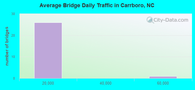
- 247,750Total average daily traffic
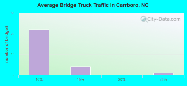
- 28,663Total average daily truck traffic
- National Bridge Inventory (NBI) Registered Bridges for Carrboro
- No street view available for this location
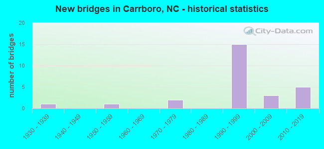
- New bridges - historical statistics
- 11930-1939
- 11950-1959
- 21970-1979
- 151990-1999
- 32000-2009
- 52010-2019
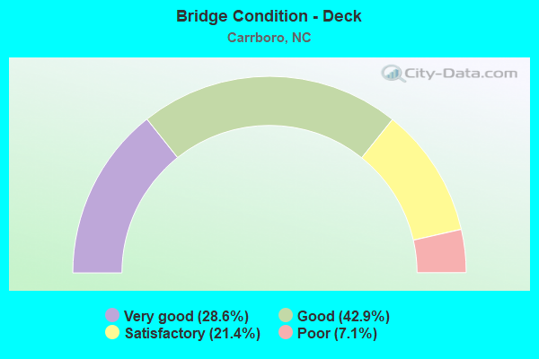
- Bridge Condition - Deck
- 28.6%Very good
- 42.9%Good
- 21.4%Satisfactory
- 7.1%Poor
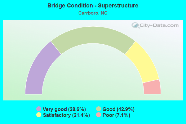
- Bridge Condition - Superstructure
- 28.6%Very good
- 42.9%Good
- 21.4%Satisfactory
- 7.1%Poor
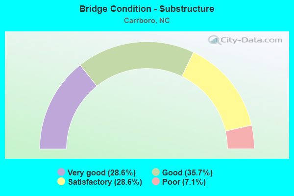
- Bridge Condition - Substructure
- 28.6%Very good
- 35.7%Good
- 28.6%Satisfactory
- 7.1%Poor
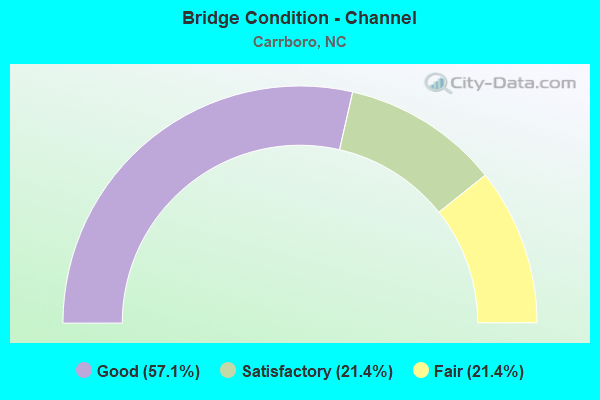
- Bridge Condition - Channel
- 57.1%Good
- 21.4%Satisfactory
- 21.4%Fair
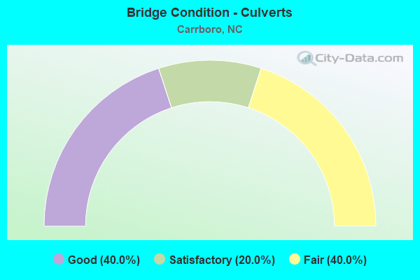
- Bridge Condition - Culverts
- 40.0%Good
- 20.0%Satisfactory
- 40.0%Fair
Find on map >> Show street view
Structure Number: 1350036, Location: 0.2 MI. E. JCT. SR1010 (Lat: 35.923786, Lng: -79.114994), Route carried "on" structure: State highway 54, Year Built: 1976, Status: Open, Structure Length: 0.82m (2.69ft), Average Daily Traffic: 15,500 (year 2019), Truck Traffic: 6%, Average Future Daily Traffic: 31,000 (year 2040), Design Load: HS 20+Mod, Features Intersected: MORGAN CREEK
Minimum Vertical Clearance: 30+ m (98+ ft), Kilometerpoint: 0.000, Lanes on structure: 2, Owner: State Highway Agency, Approaching Roadway Width: 9.7m (31.8ft), Material/Design: Concrete continuous, Design/Construction: Culvert, Number Of Spans In Main Unit: 2, Length of Maximum Span: 3.9m (12.8ft)
Condition: Channel: Fair, Culverts: Fair, Operating Rating: 41.7 metric tons, Method Used To Determine Operating Rating: Field evaluation and documented engineering judgment, Inventory Rating: 32.6 metric tons, Method Used To Determine Inventory Rating: Field evaluation and documented engineering judgment, Structural Evaluation: Somewhat better than minimum adequacy, Waterway Adequacy: Better than present minimum criteria, Approach Roadway Alignment: Equal to present desirable criteria, Designated Inspection Frequency: Every 24 months, Inspection Date: June 2021
Find on map >> Show street view
Structure Number: 135004, Location: 1.9 MI. E. JCT. SR1120 (Lat: 36.072675, Lng: -79.159739), Route carried "on" structure: Interstate 40, Year Built: 1996, Status: Open, Structure Length: 3.56m (11.68ft), Average Daily Traffic: 58,000 (year 2019), Truck Traffic: 23%, Average Future Daily Traffic: 116,000 (year 2040), Design Load: HS 20+Mod, Features Intersected: SR1239
Minimum Vertical Clearance: 30+ m (98+ ft), Kilometerpoint: 49.042, Lanes on structure: 4, Lanes under structure: 3, Base Highway Network: Yes (Inventory Route: 1, Subroute: 85), Owner: State Highway Agency, Approaching Roadway Width: 23.4m (76.8ft), Skew: 11 degrees, Material/Design: Steel, Design/Construction: Stringer/Multi-beam, Number Of Spans In Main Unit: 1, Length of Maximum Span: 34.4m (112.9ft), Curb-To-Curb Width: 23.1m (75.8ft), Out-to-Out Width: 24.2m (79.4ft)
Condition: Deck: Good, Superstructure: Good, Substructure: Good, Operating Rating: 89.8 metric tons, Method Used To Determine Operating Rating: Load Factor (LF), Inventory Rating: 59.8 metric tons, Method Used To Determine Inventory Rating: Load Factor (LF), Structural Evaluation: Better than present minimum criteria, Deck Geometry: Superior to present desirable criteria, Underclear: Meets minimum limits, Approach Roadway Alignment: Equal to present desirable criteria, Designated Inspection Frequency: Every 24 months, Inspection Date: December 2020, Deck Structure Type: Concrete Cast-file-Place, Wearing Surface/Protective System: Wearing Surface: Monolithic Concrete, Deck Protection: Epoxy Coated Reinforcing
Find on map >> Show street view
Structure Number: 1350048, Location: 0.8 MI. W. JCT. SR1919 (Lat: 35.905711, Lng: -79.086539), Route carried "on" structure: State highway 54, Year Built: 1994, Status: Open, Structure Length: 5.09m (16.70ft), Average Daily Traffic: 12,500 (year 2017), Truck Traffic: 12%, Average Future Daily Traffic: 25,000 (year 2040), Design Load: HS 20+Mod, Features Intersected: SR1005
Minimum Vertical Clearance: 30+ m (98+ ft), Kilometerpoint: 0.000, Lanes on structure: 2, Lanes under structure: 6, Base Highway Network: Yes (Inventory Route: 3, Subroute: 54), Owner: State Highway Agency, Approaching Roadway Width: 10.9m (35.8ft), Skew: 11 degrees, Material/Design: Steel, Design/Construction: Stringer/Multi-beam, Number Of Spans In Main Unit: 3, Length of Maximum Span: 28.9m (94.8ft), Curb-To-Curb Width: 10.9m (35.8ft), Out-to-Out Width: 11.9m (39.0ft)
Condition: Deck: Satisfactory, Superstructure: Satisfactory, Substructure: Satisfactory, Operating Rating: 89.8 metric tons, Method Used To Determine Operating Rating: Load Factor (LF), Inventory Rating: 58.0 metric tons, Method Used To Determine Inventory Rating: Load Factor (LF), Structural Evaluation: Equal to present minimum criteria, Deck Geometry: Meets minimum limits, Underclear: Meets minimum limits, Approach Roadway Alignment: Equal to present desirable criteria, Designated Inspection Frequency: Every 24 months, Inspection Date: March 2020, Deck Structure Type: Concrete Cast-file-Place, Wearing Surface/Protective System: Wearing Surface: Monolithic Concrete, Deck Protection: Epoxy Coated Reinforcing
Find on map >> Show street view
Structure Number: 1350061, Location: 0.2 MI. W. JCT. SR1548 (Lat: 36.115547, Lng: -79.004450), Route carried "on" structure: State highway 1002, Year Built: 2017, Status: Open, Structure Length: 0.67m (2.20ft), Average Daily Traffic: 3,000 (year 2019), Truck Traffic: 7%, Average Future Daily Traffic: 6,000 (year 2040), Design Load: HL 93, Features Intersected: BUCK QUARTER CREEK
Minimum Vertical Clearance: 30+ m (98+ ft), Kilometerpoint: 0.000, Lanes on structure: 2, Owner: State Highway Agency, Approaching Roadway Width: 12.4m (40.7ft), Skew: 2 degrees, Material/Design: Concrete continuous, Design/Construction: Culvert, Number Of Spans In Main Unit: 2, Length of Maximum Span: 3.0m (9.8ft)
Condition: Channel: Fair, Culverts: Good, Operating Rating: 69.8 metric tons, Method Used To Determine Operating Rating: Load and Resistance Factor (LRFR), Inventory Rating: 53.5 metric tons, Method Used To Determine Inventory Rating: Load and Resistance Factor (LRFR), Structural Evaluation: Better than present minimum criteria, Waterway Adequacy: Better than present minimum criteria, Approach Roadway Alignment: Equal to present desirable criteria, Designated Inspection Frequency: Every 24 months, Inspection Date: October 2020
Find on map >> Show street view
Structure Number: 1350062, Location: 1.1 MI. W. JCT. US15/501 (Lat: 35.901197, Lng: -79.073333), Route carried "on" structure: State highway 54, Year Built: 1994, Status: Open, Structure Length: 4.96m (16.27ft), Average Daily Traffic: 18,000 (year 2015), Truck Traffic: 12%, Average Future Daily Traffic: 36,000 (year 2040), Design Load: HS 20+Mod, Features Intersected: SR1919
Minimum Vertical Clearance: 30+ m (98+ ft), Kilometerpoint: 0.000, Lanes on structure: 2, Lanes under structure: 7, Base Highway Network: Yes (Inventory Route: 3, Subroute: 54), Owner: State Highway Agency, Approaching Roadway Width: 11.2m (36.7ft), Skew: 10 degrees, Material/Design: Steel, Design/Construction: Stringer/Multi-beam, Number Of Spans In Main Unit: 3, Number Of Approach Spans: 2, Length of Maximum Span: 31.3m (102.7ft), Curb-To-Curb Width: 10.9m (35.8ft), Out-to-Out Width: 11.9m (39.0ft)
Condition: Deck: Good, Superstructure: Good, Substructure: Good, Operating Rating: 89.8 metric tons, Method Used To Determine Operating Rating: Load Factor (LF), Inventory Rating: 58.0 metric tons, Method Used To Determine Inventory Rating: Load Factor (LF), Structural Evaluation: Better than present minimum criteria, Deck Geometry: Meets minimum limits, Underclear: Meets minimum limits, Approach Roadway Alignment: Equal to present desirable criteria, Designated Inspection Frequency: Every 24 months, Inspection Date: October 2021, Deck Structure Type: Concrete Cast-file-Place, Wearing Surface/Protective System: Wearing Surface: Monolithic Concrete, Deck Protection: Epoxy Coated Reinforcing
Find on map >> Show street view
Structure Number: 1350076, Location: 0.4 MI. W. JCT. SR1009 (Lat: 35.999711, Lng: -79.114822), Route carried "on" structure: State highway 1113, Year Built: 2013, Status: Open, Structure Length: 2.80m (9.19ft), Average Daily Traffic: 2,400 (year 2018), Truck Traffic: 6%, Average Future Daily Traffic: 4,800 (year 2040), Design Load: HL 93, Features Intersected: NEW HOPE CREEK
Minimum Vertical Clearance: 30+ m (98+ ft), Kilometerpoint: 0.000, Lanes on structure: 2, Owner: State Highway Agency, Approaching Roadway Width: 8.5m (27.9ft), Material/Design: Prestressed concrete, Design/Construction: Box Beam or Girders - Multiple, Number Of Spans In Main Unit: 1, Length of Maximum Span: 27.1m (88.9ft), Curb-To-Curb Width: 8.4m (27.6ft), Out-to-Out Width: 9.1m (29.9ft)
Condition: Deck: Very good, Superstructure: Very good, Substructure: Very good, Channel: Good, Operating Rating: 69.8 metric tons, Method Used To Determine Operating Rating: Load and Resistance Factor (LRFR), Inventory Rating: 48.9 metric tons, Method Used To Determine Inventory Rating: Load and Resistance Factor (LRFR), Structural Evaluation: Equal to present desirable criteria, Deck Geometry: High priority of corrective action, Waterway Adequacy: Better than present minimum criteria, Approach Roadway Alignment: Equal to present desirable criteria, Designated Inspection Frequency: Every 24 months, Inspection Date: July 2021, Deck Structure Type: Concrete Precast Panels, Wearing Surface/Protective System: Wearing Surface: Bituminous, Deck Protection: Epoxy Coated Reinforcing
Find on map >> Show street view
Structure Number: 1350077, Location: 0.8 MI. W. JCT. SR1009 (Lat: 35.998794, Lng: -79.121383), Route carried "on" structure: State highway 1113, Year Built: 2018, Status: Open, Structure Length: 1.73m (5.68ft), Average Daily Traffic: 2,400 (year 2015), Truck Traffic: 6%, Average Future Daily Traffic: 4,800 (year 2040), Design Load: HL 93, Features Intersected: NEW HOPE CREEK
Minimum Vertical Clearance: 30+ m (98+ ft), Kilometerpoint: 0.000, Lanes on structure: 2, Owner: State Highway Agency, Approaching Roadway Width: 9.4m (30.8ft), Material/Design: Prestressed concrete, Design/Construction: Slab, Number Of Spans In Main Unit: 1, Length of Maximum Span: 16.4m (53.8ft), Curb-To-Curb Width: 9.2m (30.2ft), Out-to-Out Width: 10.0m (32.8ft)
Condition: Deck: Very good, Superstructure: Very good, Substructure: Very good, Channel: Good, Operating Rating: 61.6 metric tons, Method Used To Determine Operating Rating: Load and Resistance Factor (LRFR), Inventory Rating: 42.6 metric tons, Method Used To Determine Inventory Rating: Load and Resistance Factor (LRFR), Structural Evaluation: Equal to present desirable criteria, Deck Geometry: Meets minimum limits, Waterway Adequacy: Better than present minimum criteria, Approach Roadway Alignment: Equal to present desirable criteria, Designated Inspection Frequency: Every 24 months, Inspection Date: October 2020, Deck Structure Type: Concrete Precast Panels, Wearing Surface/Protective System: Wearing Surface: Bituminous, Deck Protection: Epoxy Coated Reinforcing
Find on map >> Show street view
Structure Number: 1350085, Location: 0.3 MI. W. OF JCT. SR1944 (Lat: 35.905642, Lng: -79.099422), Route carried "on" structure: State highway 1005, Year Built: 2018, Status: Open, Structure Length: 3.16m (10.37ft), Average Daily Traffic: 4,900 (year 2019), Truck Traffic: 7%, Average Future Daily Traffic: 9,800 (year 2040), Design Load: HL 93, Features Intersected: PHILS CREEK
Minimum Vertical Clearance: 30+ m (98+ ft), Kilometerpoint: 0.000, Lanes on structure: 2, Owner: State Highway Agency, Approaching Roadway Width: 9.1m (29.9ft), Material/Design: Prestressed concrete, Design/Construction: Box Beam or Girders - Multiple, Number Of Spans In Main Unit: 1, Length of Maximum Span: 30.7m (100.7ft), Curb-To-Curb Width: 10.0m (32.8ft), Out-to-Out Width: 10.9m (35.8ft)
Condition: Deck: Very good, Superstructure: Very good, Substructure: Very good, Channel: Good, Operating Rating: 73.4 metric tons, Method Used To Determine Operating Rating: Load and Resistance Factor (LRFR), Inventory Rating: 47.1 metric tons, Method Used To Determine Inventory Rating: Load and Resistance Factor (LRFR), Structural Evaluation: Equal to present desirable criteria, Deck Geometry: Meets minimum limits, Waterway Adequacy: Better than present minimum criteria, Approach Roadway Alignment: Equal to present desirable criteria, Designated Inspection Frequency: Every 24 months, Inspection Date: October 2021, Deck Structure Type: Concrete Precast Panels, Wearing Surface/Protective System: Wearing Surface: Bituminous
Find on map >> Show street view
Structure Number: 1350086, Location: 0.2 MI. E. JCT. SR1942 (Lat: 35.902883, Lng: -79.097250), Route carried "on" structure: State highway 1005, Year Built: 1939, Year Reconstructed: 1976, Status: Posted for load, Structure Length: 3.68m (12.07ft), Average Daily Traffic: 9,800 (year 2019), Truck Traffic: 8%, Average Future Daily Traffic: 19,600 (year 2040), Features Intersected: UNIVERSITY LAKE
Minimum Vertical Clearance: 30+ m (98+ ft), Kilometerpoint: 0.000, Lanes on structure: 2, Base Highway Network: Yes (Inventory Route: 3, Subroute: 5), Owner: State Highway Agency, Approaching Roadway Width: 7.6m (24.9ft), Material/Design: Steel, Design/Construction: Stringer/Multi-beam, Number Of Spans In Main Unit: 3, Length of Maximum Span: 12.1m (39.7ft), Curb-To-Curb Width: 8.5m (27.9ft), Out-to-Out Width: 8.5m (27.9ft)
Condition: Deck: Poor, Superstructure: Poor, Substructure: Poor, Channel: Good, Operating Rating: 37.1 metric tons, Method Used To Determine Operating Rating: Load Factor (LF), Inventory Rating: 21.7 metric tons, Method Used To Determine Inventory Rating: Load Factor (LF), Structural Evaluation: Meets minimum limits, Deck Geometry: High priority of replacement, Waterway Adequacy: Equal to present minimum criteria, Approach Roadway Alignment: Equal to present desirable criteria, Bridge Posting: Required (Relationship of Operating Rating to Maximum Legal Load: 10.0 - 19.9% below), Designated Inspection Frequency: Every 24 months, Underwater Inspection Frequency: Every 60 months, Inspection Date: September 2021, Underwater Inspection Date: September 2021, Deck Structure Type: Corrugated Steel, Wearing Surface/Protective System: Wearing Surface: Bituminous
Find on map >> Show street view
Structure Number: 1350088, Location: 0.2 MI. S. JCT. NC54 (Lat: 35.899817, Lng: -79.074217), Route carried "on" structure: State highway 1919, Year Built: 1994, Status: Open, Structure Length: 5.24m (17.19ft), Average Daily Traffic: 17,500 (year 2019), Truck Traffic: 6%, Average Future Daily Traffic: 35,000 (year 2040), Design Load: HS 20+Mod, Features Intersected: MORGAN CREEK
Minimum Vertical Clearance: 30+ m (98+ ft), Kilometerpoint: 0.000, Lanes on structure: 5, Owner: State Highway Agency, Approaching Roadway Width: 14.3m (46.9ft), Material/Design: Prestressed concrete, Design/Construction: Slab, Number Of Spans In Main Unit: 4, Length of Maximum Span: 12.8m (42.0ft), Curb or Sidewalk Widths: Left: 1.3m (4.3ft), Right: 0.0m, Curb-To-Curb Width: 19.8m (65.0ft), Out-to-Out Width: 21.9m (71.9ft)
Condition: Deck: Satisfactory, Superstructure: Satisfactory, Substructure: Satisfactory, Channel: Good, Operating Rating: 76.2 metric tons, Method Used To Determine Operating Rating: Load Factor (LF), Inventory Rating: 45.3 metric tons, Method Used To Determine Inventory Rating: Load Factor (LF), Structural Evaluation: Equal to present minimum criteria, Deck Geometry: Meets minimum limits, Waterway Adequacy: Better than present minimum criteria, Approach Roadway Alignment: Equal to present desirable criteria, Designated Inspection Frequency: Every 24 months, Inspection Date: July 2021, Deck Structure Type: Concrete Precast Panels, Wearing Surface/Protective System: Wearing Surface: Bituminous
Find on map >> Show street view
Structure Number: 1350092, Location: 0.4 MI. W. JCT. SR1005 (Lat: 35.900081, Lng: -79.107158), Route carried "on" structure: State highway 1942, Year Built: 1976, Status: Open, Structure Length: 2.77m (9.09ft), Average Daily Traffic: 9,500 (year 2017), Truck Traffic: 6%, Average Future Daily Traffic: 19,000 (year 2040), Design Load: HS 20+Mod, Features Intersected: PHILS CREEK
Minimum Vertical Clearance: 30+ m (98+ ft), Kilometerpoint: 0.000, Lanes on structure: 2, Owner: State Highway Agency, Approaching Roadway Width: 8.8m (28.9ft), Material/Design: Prestressed concrete, Design/Construction: Slab, Number Of Spans In Main Unit: 3, Length of Maximum Span: 8.8m (28.9ft), Curb-To-Curb Width: 10.4m (34.1ft), Out-to-Out Width: 10.8m (35.4ft)
Condition: Deck: Satisfactory, Superstructure: Satisfactory, Substructure: Satisfactory, Channel: Good, Operating Rating: 68.0 metric tons, Method Used To Determine Operating Rating: Load Factor (LF), Inventory Rating: 40.8 metric tons, Method Used To Determine Inventory Rating: Load Factor (LF), Structural Evaluation: Equal to present minimum criteria, Deck Geometry: Meets minimum limits, Waterway Adequacy: Better than present minimum criteria, Approach Roadway Alignment: Equal to present minimum criteria, Designated Inspection Frequency: Every 24 months, Underwater Inspection Frequency: Every 60 months, Inspection Date: May 2020, Underwater Inspection Date: March 2019, Deck Structure Type: Concrete Precast Panels, Wearing Surface/Protective System: Wearing Surface: Bituminous
Find on map >> Show street view
Structure Number: 1350094, Location: 0.8 MI. E. JCT. SR1728 (Lat: 35.943025, Lng: -79.085472), Route carried "on" structure: State highway 1777, Year Built: 1992, Status: Open, Structure Length: 2.80m (9.19ft), Average Daily Traffic: 8,000 (year 2017), Truck Traffic: 6%, Average Future Daily Traffic: 16,000 (year 2040), Design Load: HS 20+Mod, Features Intersected: BOLIN CREEK
Minimum Vertical Clearance: 30+ m (98+ ft), Kilometerpoint: 0.000, Lanes on structure: 2, Owner: State Highway Agency, Approaching Roadway Width: 8.8m (28.9ft), Material/Design: Prestressed concrete, Design/Construction: Slab, Number Of Spans In Main Unit: 3, Length of Maximum Span: 9.1m (29.9ft), Curb-To-Curb Width: 9.1m (29.9ft), Out-to-Out Width: 10.0m (32.8ft)
Condition: Deck: Good, Superstructure: Good, Substructure: Good, Channel: Good, Operating Rating: 89.8 metric tons, Method Used To Determine Operating Rating: Load Factor (LF), Inventory Rating: 75.2 metric tons, Method Used To Determine Inventory Rating: Load Factor (LF), Structural Evaluation: Better than present minimum criteria, Deck Geometry: High priority of corrective action, Waterway Adequacy: Better than present minimum criteria, Approach Roadway Alignment: Equal to present desirable criteria, Designated Inspection Frequency: Every 24 months, Inspection Date: June 2020, Deck Structure Type: Concrete Precast Panels, Wearing Surface/Protective System: Wearing Surface: Bituminous
Find on map >> Show street view
Structure Number: 1350232, Location: 1.1 MI. S. JCT. NC54 (Lat: 35.912000, Lng: -79.134033), Route carried "on" structure: State highway 1945, Year Built: 2014, Status: Open, Structure Length: 2.80m (9.19ft), Average Daily Traffic: 650 (year 2018), Truck Traffic: 6%, Average Future Daily Traffic: 1,300 (year 2040), Design Load: HL 93, Features Intersected: PHIL'S CREEK
Minimum Vertical Clearance: 30+ m (98+ ft), Kilometerpoint: 0.000, Lanes on structure: 2, Owner: State Highway Agency, Approaching Roadway Width: 8.2m (26.9ft), Material/Design: Prestressed concrete, Design/Construction: Box Beam or Girders - Multiple, Number Of Spans In Main Unit: 1, Length of Maximum Span: 27.1m (88.9ft), Curb-To-Curb Width: 8.3m (27.2ft), Out-to-Out Width: 9.1m (29.9ft)
Condition: Deck: Very good, Superstructure: Very good, Substructure: Very good, Channel: Good, Operating Rating: 69.8 metric tons, Method Used To Determine Operating Rating: Load and Resistance Factor (LRFR), Inventory Rating: 48.9 metric tons, Method Used To Determine Inventory Rating: Load and Resistance Factor (LRFR), Structural Evaluation: Equal to present desirable criteria, Deck Geometry: Somewhat better than minimum adequacy, Waterway Adequacy: Better than present minimum criteria, Approach Roadway Alignment: Equal to present desirable criteria, Designated Inspection Frequency: Every 24 months, Inspection Date: January 2022, Deck Structure Type: Concrete Cast-file-Place, Wearing Surface/Protective System: Wearing Surface: Bituminous
Find on map >> Show street view
Structure Number: 135028, Location: 0.3 MI. S. JCT. SR1507 (Lat: 36.170000, Lng: -79.100128), Route carried "on" structure: State highway 1001, Year Built: 1955, Status: Open, Structure Length: 0.79m (2.59ft), Average Daily Traffic: 1,300 (year 2017), Truck Traffic: 6%, Average Future Daily Traffic: 2,600 (year 2040), Design Load: HS 20+Mod, Features Intersected: RAYS CREEK
Minimum Vertical Clearance: 30+ m (98+ ft), Kilometerpoint: 0.000, Lanes on structure: 2, Owner: State Highway Agency, Approaching Roadway Width: 5.4m (17.7ft), Skew: 3 degrees, Material/Design: Steel, Design/Construction: Culvert, Number Of Spans In Main Unit: 3, Length of Maximum Span: 1.8m (5.9ft)
Condition: Channel: Fair, Culverts: Fair, Operating Rating: 89.8 metric tons, Method Used To Determine Operating Rating: Load and Resistance Factor (LRFR), Inventory Rating: 89.8 metric tons, Method Used To Determine Inventory Rating: Load and Resistance Factor (LRFR), Structural Evaluation: Somewhat better than minimum adequacy, Waterway Adequacy: Better than present minimum criteria, Approach Roadway Alignment: Equal to present desirable criteria, Designated Inspection Frequency: Every 24 months, Inspection Date: May 2020
Find on map >> Show street view
Structure Number: 1350285, Location: 0.8 MI. W. JCT. SR1919 (Lat: 35.905758, Lng: -79.086394), Route carried "on" structure: State highway 54, Year Built: 1994, Status: Open, Structure Length: 4.87m (15.98ft), Average Daily Traffic: 12,500 (year 2017), Truck Traffic: 12%, Average Future Daily Traffic: 25,000 (year 2040), Design Load: HS 20+Mod, Features Intersected: SR1005
Minimum Vertical Clearance: 30+ m (98+ ft), Kilometerpoint: 0.000, Lanes on structure: 2, Lanes under structure: 6, Base Highway Network: Yes (Inventory Route: 3, Subroute: 54), Owner: State Highway Agency, Approaching Roadway Width: 10.6m (34.8ft), Skew: 11 degrees, Material/Design: Steel, Design/Construction: Stringer/Multi-beam, Number Of Spans In Main Unit: 3, Length of Maximum Span: 28.9m (94.8ft), Curb-To-Curb Width: 10.9m (35.8ft), Out-to-Out Width: 11.9m (39.0ft)
Condition: Deck: Good, Superstructure: Good, Substructure: Satisfactory, Operating Rating: 89.8 metric tons, Method Used To Determine Operating Rating: Load Factor (LF), Inventory Rating: 59.8 metric tons, Method Used To Determine Inventory Rating: Load Factor (LF), Structural Evaluation: Equal to present minimum criteria, Deck Geometry: Meets minimum limits, Underclear: Meets minimum limits, Approach Roadway Alignment: Equal to present desirable criteria, Designated Inspection Frequency: Every 24 months, Inspection Date: March 2020, Deck Structure Type: Concrete Cast-file-Place, Wearing Surface/Protective System: Wearing Surface: Monolithic Concrete, Deck Protection: Epoxy Coated Reinforcing
Find on map >> Show street view
Structure Number: 1350286, Location: 0.8 MI. E. JCT. SR1006 (Lat: 35.901342, Lng: -79.073250), Route carried "on" structure: Bypass State highway 54, Year Built: 1994, Status: Open, Structure Length: 5.02m (16.47ft), Average Daily Traffic: 17,000 (year 2017), Truck Traffic: 12%, Average Future Daily Traffic: 34,000 (year 2040), Design Load: HS 20+Mod, Features Intersected: SR1919
Minimum Vertical Clearance: 30+ m (98+ ft), Kilometerpoint: 0.000, Lanes on structure: 2, Lanes under structure: 7, Base Highway Network: Yes (Inventory Route: 3, Subroute: 54), Owner: State Highway Agency, Approaching Roadway Width: 11.2m (36.7ft), Skew: 10 degrees, Material/Design: Steel, Design/Construction: Stringer/Multi-beam, Number Of Spans In Main Unit: 3, Number Of Approach Spans: 2, Length of Maximum Span: 31.3m (102.7ft), Curb-To-Curb Width: 10.9m (35.8ft), Out-to-Out Width: 11.9m (39.0ft)
Condition: Deck: Good, Superstructure: Good, Substructure: Good, Operating Rating: 89.8 metric tons, Method Used To Determine Operating Rating: Load Factor (LF), Inventory Rating: 63.5 metric tons, Method Used To Determine Inventory Rating: Load Factor (LF), Structural Evaluation: Better than present minimum criteria, Deck Geometry: Meets minimum limits, Underclear: Meets minimum limits, Approach Roadway Alignment: Equal to present desirable criteria, Designated Inspection Frequency: Every 24 months, Inspection Date: October 2021, Deck Structure Type: Concrete Cast-file-Place, Wearing Surface/Protective System: Wearing Surface: Monolithic Concrete, Deck Protection: Epoxy Coated Reinforcing
Find on map >> Show street view
Structure Number: 1350327, Location: .5 MI.N.JCT.HOMESTEAD RD (Lat: 35.950386, Lng: -79.097778), Route carried "on" structure: City street , Year Built: 2003, Status: Open, Structure Length: 0.73m (2.40ft), Average Daily Traffic: 4,500 (year 2001), Truck Traffic: 7%, Average Future Daily Traffic: 81,000 (year 2040), Design Load: HS 20, Features Intersected: BOLIN CREEK, Facility Carried by Structure: LAKE HOGAN FARM RD
Minimum Vertical Clearance: 30+ m (98+ ft), Kilometerpoint: 0.000, Lanes on structure: 2, Owner: City or Municipal Highway Agency, Approaching Roadway Width: 10.6m (34.8ft), Material/Design: Concrete continuous, Design/Construction: Culvert, Number Of Spans In Main Unit: 1, Length of Maximum Span: 7.3m (24.0ft), Curb or Sidewalk Widths: Left: 1.6m (5.2ft), Right: 1.6m (5.2ft), Curb-To-Curb Width: 10.3m (33.8ft), Out-to-Out Width: 14.6m (47.9ft)
Condition: Channel: Satisfactory, Culverts: Good, Operating Rating: 41.7 metric tons, Method Used To Determine Operating Rating: Field evaluation and documented engineering judgment, Inventory Rating: 32.6 metric tons, Method Used To Determine Inventory Rating: Field evaluation and documented engineering judgment, Structural Evaluation: Better than present minimum criteria, Deck Geometry: Meets minimum limits, Waterway Adequacy: Better than present minimum criteria, Approach Roadway Alignment: Equal to present desirable criteria, Designated Inspection Frequency: Every 24 months, Inspection Date: April 2020
Find on map >> Show street view
Structure Number: 135033, Location: 0.1 MI.S.JCT.MARIN PL. (Lat: 35.894811, Lng: -79.066900), Route carried "on" structure: City street , Year Built: 2004, Status: Open, Structure Length: 0.73m (2.40ft), Average Daily Traffic: 800 (year 2005), Truck Traffic: 7%, Average Future Daily Traffic: 1,600 (year 2040), Design Load: HS 20+Mod, Features Intersected: UT TO MORGAN CREEK, Facility Carried by Structure: ADAMS WAY
Minimum Vertical Clearance: 30+ m (98+ ft), Kilometerpoint: 0.000, Lanes on structure: 2, Owner: City or Municipal Highway Agency, Approaching Roadway Width: 8.2m (26.9ft), Material/Design: Steel, Design/Construction: Culvert, Number Of Spans In Main Unit: 1, Length of Maximum Span: 7.3m (24.0ft)
Condition: Channel: Satisfactory, Culverts: Satisfactory, Operating Rating: 89.8 metric tons, Method Used To Determine Operating Rating: Load Factor (LF), Inventory Rating: 89.8 metric tons, Method Used To Determine Inventory Rating: Load Factor (LF), Structural Evaluation: Equal to present minimum criteria, Waterway Adequacy: Better than present minimum criteria, Approach Roadway Alignment: Equal to present desirable criteria, Designated Inspection Frequency: Every 24 months, Inspection Date: April 2020
Find on map >> Show street view
Structure Number: 1350339, Location: .05 MI.E.OF JEWEL DR. (Lat: 35.946106, Lng: -79.086789), Route carried "on" structure: City street , Year Built: 2008, Status: Posted for load, Structure Length: 6.73m (22.08ft), Average Daily Traffic: 1,000 (year 2009), Truck Traffic: 7%, Average Future Daily Traffic: 2,000 (year 2040), Design Load: HS 20, Features Intersected: BOLIN CREEK, Facility Carried by Structure: EAST WINMORE AVE.
Minimum Vertical Clearance: 30+ m (98+ ft), Kilometerpoint: 0.000, Lanes on structure: 2, Owner: City or Municipal Highway Agency, Approaching Roadway Width: 7.6m (24.9ft), Material/Design: Prestressed concrete, Design/Construction: Slab, Number Of Spans In Main Unit: 4, Length of Maximum Span: 17.9m (58.7ft), Curb or Sidewalk Widths: Left: 0.0m, Right: 3.0m (9.8ft), Curb-To-Curb Width: 7.7m (25.3ft), Out-to-Out Width: 11.8m (38.7ft)
Condition: Deck: Good, Superstructure: Good, Substructure: Good, Channel: Satisfactory, Operating Rating: 40.8 metric tons, Method Used To Determine Operating Rating: Load and Resistance Factor (LRFR), Inventory Rating: 30.8 metric tons, Method Used To Determine Inventory Rating: Load and Resistance Factor (LRFR), Structural Evaluation: Better than present minimum criteria, Deck Geometry: Meets minimum limits, Waterway Adequacy: Superior to present desirable criteria, Approach Roadway Alignment: Equal to present minimum criteria, Bridge Posting: Required (Relationship of Operating Rating to Maximum Legal Load: 10.0 - 19.9% below), Designated Inspection Frequency: Every 24 months, Inspection Date: April 2020, Deck Structure Type: Concrete Precast Panels, Wearing Surface/Protective System: Wearing Surface: Bituminous
Find on map >> Show street view
Structure Number: 1350048, Location: 0.8 MI. W. JCT. SR1919 (Lat: 35.905711, Lng: -79.086539), Route carried "under" structure: State highway 1005, Year Built: 1994, Structure Length: 0. m, Average Daily Traffic: 6,000 (year 2017), Truck Traffic: 6%, Features Intersected: NC54E
Minimum Vertical Clearance: 5.79m (19.00ft), Kilometerpoint: 0.000, Lanes on structure: 2, Lanes under structure: 3, Material/Design: Steel, Design/Construction: Stringer/Multi-beam, Length of Maximum Span: 28.9m (94.8ft)
Find on map >> Show street view
Structure Number: 1350062, Location: 1.1 MI. W. JCT. US15/501 (Lat: 35.901197, Lng: -79.073333), Route carried "under" structure: State highway 1919, Year Built: 1994, Structure Length: 0. m, Average Daily Traffic: 6,000 (year 2015), Truck Traffic: 6%, Features Intersected: NC54E
Minimum Vertical Clearance: 6.07m (19.91ft), Kilometerpoint: 0.000, Lanes on structure: 2, Lanes under structure: 4, Material/Design: Steel, Design/Construction: Stringer/Multi-beam, Length of Maximum Span: 31.3m (102.7ft)
Find on map >> Show street view
Structure Number: 1350062, Location: 1.1 MI. W. JCT. US15/501 (Lat: 35.901197, Lng: -79.073333), Route carried "under" structure: State highway 1919, Year Built: 1994, Structure Length: 0. m, Average Daily Traffic: 6,000 (year 2015), Truck Traffic: 6%, Features Intersected: NC54E
Minimum Vertical Clearance: 5.53m (18.14ft), Kilometerpoint: 0.000, Lanes on structure: 2, Lanes under structure: 3, Material/Design: Steel, Design/Construction: Stringer/Multi-beam, Length of Maximum Span: 31.3m (102.7ft)
Find on map >> Show street view
Structure Number: 1350285, Location: 0.8 MI. W. JCT. SR1919 (Lat: 35.905758, Lng: -79.086394), Route carried "under" structure: State highway 1005, Year Built: 1994, Structure Length: 0. m, Average Daily Traffic: 6,000 (year 2017), Truck Traffic: 6%, Features Intersected: NC54W
Minimum Vertical Clearance: 5.23m (17.16ft), Kilometerpoint: 0.000, Lanes on structure: 2, Lanes under structure: 3, Material/Design: Steel, Design/Construction: Stringer/Multi-beam, Length of Maximum Span: 28.9m (94.8ft)
Find on map >> Show street view
Structure Number: 1350285, Location: 0.8 MI. W. JCT. SR1919 (Lat: 35.905758, Lng: -79.086394), Route carried "under" structure: State highway , Year Built: 1994, Structure Length: 0. m, Average Daily Traffic: 6,000 (year 2017), Truck Traffic: 6%, Features Intersected: NC54W, Facility Carried by Structure: SR1005N
Minimum Vertical Clearance: 5.23m (17.16ft), Kilometerpoint: 0.000, Lanes on structure: 2, Lanes under structure: 3, Material/Design: Steel, Design/Construction: Stringer/Multi-beam, Length of Maximum Span: 28.9m (94.8ft)
Find on map >> Show street view
Structure Number: 1350286, Location: 0.8 MI. E. JCT. SR1006 (Lat: 35.901342, Lng: -79.073250), Route carried "under" structure: State highway 1919, Year Built: 1994, Structure Length: 0. m, Average Daily Traffic: 6,250 (year 2019), Truck Traffic: 6%, Features Intersected: NC54W
Minimum Vertical Clearance: 5.63m (18.47ft), Kilometerpoint: 0.000, Lanes on structure: 2, Lanes under structure: 4, Material/Design: Steel, Design/Construction: Stringer/Multi-beam, Length of Maximum Span: 31.3m (102.7ft)
Find on map >> Show street view
Structure Number: 1350286, Location: 0.8 MI. E. JCT. SR1006 (Lat: 35.901342, Lng: -79.073250), Route carried "under" structure: State highway 1919, Year Built: 1994, Structure Length: 0. m, Average Daily Traffic: 6,250 (year 2019), Truck Traffic: 6%, Features Intersected: NC54W
Minimum Vertical Clearance: 5.25m (17.22ft), Kilometerpoint: 0.000, Lanes on structure: 2, Lanes under structure: 3, Material/Design: Steel, Design/Construction: Stringer/Multi-beam, Length of Maximum Span: 31.3m (102.7ft)