Bridge Statistics for Cape Canaveral, Florida (FL)
Condition, Traffic, Stress, Structural Evaluation, Project Costs
- National Bridge Inventory (NBI) Statistics
- 20Number of bridges
- 213ft / 64.6mTotal length
- $203,000Total costs
- 199,720Total average daily traffic
- 14,578Total average daily truck traffic
- National Bridge Inventory (NBI) Registered Bridges for Cape Canaveral
- No street view available for this location
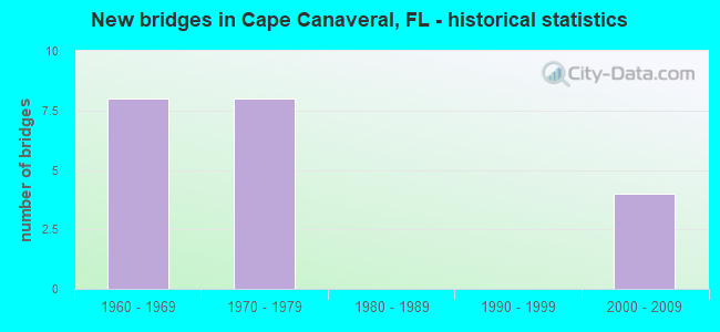
- New bridges - historical statistics
- 81960-1969
- 81970-1979
- 42000-2009

- Reconstructed bridges - Historical Statistics
- 11970-1979
- 01980-1989
- 21990-1999
- 12000-2009
- 12010-2019


- Bridge Condition - Deck
- 66.7%Good
- 33.3%Satisfactory

- Bridge Condition - Superstructure
- 66.7%Good
- 11.1%Satisfactory
- 22.2%Fair

- Bridge Condition - Substructure
- 55.6%Good
- 33.3%Satisfactory
- 11.1%Fair

- Bridge Condition - Channel
- 66.7%Good
- 33.3%Satisfactory
Find on map >> Show street view
Structure Number: 700014, Location: SR-528 WB - US-1 & FECRR (Lat: 28.400403, Lng: -80.752983), Route carried "on" structure: State highway 528, Year Built: 1963, Year Reconstructed: 1970, Status: Open, Structure Length: 9.89m (32.45ft), Average Daily Traffic: 20,000 (year 2020), Truck Traffic: 8%, Average Future Daily Traffic: 34,700 (year 2042), Design Load: HS 20, Features Intersected: US-1 & FECRR
Minimum Vertical Clearance: 30+ m (98+ ft), Kilometerpoint: 8.684, Lanes on structure: 3, Lanes under structure: 8, Base Highway Network: Yes, Owner: State Highway Agency, Approaching Roadway Width: 7.7m (25.3ft), Skew: 1 degrees, Material/Design: Prestressed concrete, Design/Construction: Stringer/Multi-beam, Number Of Spans In Main Unit: 5, Length of Maximum Span: 22.9m (75.1ft), Curb-To-Curb Width: 12.2m (40.0ft), Out-to-Out Width: 13.7m (44.9ft)
Condition: Deck: Good, Superstructure: Good, Substructure: Good, Operating Rating: 67.9 metric tons, Method Used To Determine Operating Rating: Load Factor (LF), Inventory Rating: 41.8 metric tons, Method Used To Determine Inventory Rating: Load Factor (LF), Structural Evaluation: Better than present minimum criteria, Deck Geometry: High priority of corrective action, Underclear: Somewhat better than minimum adequacy, Approach Roadway Alignment: Equal to present desirable criteria, Designated Inspection Frequency: Every 24 months, Inspection Date: October 2021, Deck Structure Type: Concrete Cast-file-Place
Find on map >> Show street view
Structure Number: 700025, Location: SR-528 WB - Sykes Creek (Lat: 28.405392, Lng: -80.694242), Route carried "on" structure: State highway 528, Year Built: 1963, Year Reconstructed: 2002, Status: Open, Structure Length: 3.72m (12.20ft), Average Daily Traffic: 15,250 (year 2020), Truck Traffic: 5%, Average Future Daily Traffic: 26,459 (year 2042), Design Load: HS 20+Mod, Features Intersected: Sykes Creek
Minimum Vertical Clearance: 30+ m (98+ ft), Kilometerpoint: 14.502, Lanes on structure: 2, Base Highway Network: Yes, Owner: State Highway Agency, Approaching Roadway Width: 12.1m (39.7ft), Material/Design: Prestressed concrete, Design/Construction: Stringer/Multi-beam, Number Of Spans In Main Unit: 3, Length of Maximum Span: 12.2m (40.0ft), Curb-To-Curb Width: 9.3m (30.5ft), Out-to-Out Width: 10.2m (33.5ft)
Condition: Deck: Good, Superstructure: Good, Substructure: Good, Channel: Satisfactory, Operating Rating: 75.3 metric tons, Method Used To Determine Operating Rating: Load Factor (LF), Inventory Rating: 47.6 metric tons, Method Used To Determine Inventory Rating: Load Factor (LF), Structural Evaluation: Better than present minimum criteria, Deck Geometry: High priority of replacement, Waterway Adequacy: Equal to present desirable criteria, Approach Roadway Alignment: Equal to present desirable criteria, Designated Inspection Frequency: Every 24 months, Underwater Inspection Frequency: Every 24 months, Inspection Date: March 2020, Underwater Inspection Date: March 2020
Find on map >> Show street view
Structure Number: 70003, Location: SR-401 SB - Barge Canal (Lat: 28.409203, Lng: -80.632244), Route carried "on" structure: State highway 401, Year Built: 1963, Year Reconstructed: 2011, Status: Open, Structure Length: 9.57m (31.40ft), Average Daily Traffic: 5,750 (year 2021), Truck Traffic: 16%, Average Future Daily Traffic: 9,976 (year 2042), Design Load: HS 20, Features Intersected: Service Rd & Canal
Minimum Vertical Clearance: 5.49m (18.01ft), Kilometerpoint: 7.120, Lanes on structure: 2, Lanes under structure: 2, Owner: State Highway Agency, Approaching Roadway Width: 7.3m (24.0ft), Navigation Control: Yes ( Vertical Clearance: 7.3m (24.0ft), Horizontal Clearance: 27.4m (89.9ft)), Material/Design: Steel, Design/Construction: Movable - Bascule, Number Of Spans In Main Unit: 1, Number Of Approach Spans: 4, Length of Maximum Span: 31.9m (104.7ft), Curb or Sidewalk Widths: Left: 1.1m (3.6ft), Right: 1.1m (3.6ft), Curb-To-Curb Width: 8.5m (27.9ft), Out-to-Out Width: 11.0m (36.1ft)
Condition: Deck: Satisfactory, Superstructure: Satisfactory, Substructure: Satisfactory, Channel: Good, Operating Rating: 47.6 metric tons, Method Used To Determine Operating Rating: Load Factor (LF), Inventory Rating: 28.4 metric tons, Method Used To Determine Inventory Rating: Load Factor (LF), Structural Evaluation: Equal to present minimum criteria, Deck Geometry: High priority of corrective action, Underclear: High priority of corrective action, Waterway Adequacy: Superior to present desirable criteria, Approach Roadway Alignment: Equal to present desirable criteria, Designated Inspection Frequency: Every 24 months, Critical Feature Inspection Frequency: Every 24 months, Underwater Inspection Frequency: Every 24 months, Other Special Inspection Frequency: Every 12 months, Inspection Date: September 2020, Critical Feature Inspection Date: September 2020, Underwater Inspection Date: September 2020, Other Special Inspection Date: September 2021, Deck Structure Type: Open Grating
Find on map >> Show street view
Structure Number: 700031, Location: SR-401 SB - Barge Canal (Lat: 28.409206, Lng: -80.632472), Route carried "on" structure: Ramp State highway 401, Year Built: 1963, Status: Open, Structure Length: 9.57m (31.40ft), Average Daily Traffic: 4,600 (year 2021), Truck Traffic: 5%, Average Future Daily Traffic: 7,981 (year 2042), Design Load: HS 20, Features Intersected: Service Rd & Canal
Minimum Vertical Clearance: 5.18m (16.99ft), Kilometerpoint: 0.175, Lanes on structure: 1, Lanes under structure: 2, Owner: State Highway Agency, Approaching Roadway Width: 7.5m (24.6ft), Navigation Control: Yes ( Vertical Clearance: 7.3m (24.0ft), Horizontal Clearance: 27.4m (89.9ft)), Material/Design: Steel, Design/Construction: Movable - Bascule, Number Of Spans In Main Unit: 1, Number Of Approach Spans: 4, Length of Maximum Span: 32.0m (105.0ft), Curb or Sidewalk Widths: Left: 1.1m (3.6ft), Right: 1.1m (3.6ft), Curb-To-Curb Width: 8.5m (27.9ft), Out-to-Out Width: 11.0m (36.1ft)
Condition: Deck: Satisfactory, Superstructure: Fair, Substructure: Fair, Channel: Good, Operating Rating: 47.6 metric tons, Method Used To Determine Operating Rating: Load Factor (LF), Inventory Rating: 28.4 metric tons, Method Used To Determine Inventory Rating: Load Factor (LF), Structural Evaluation: Somewhat better than minimum adequacy, Deck Geometry: Superior to present desirable criteria, Underclear: High priority of corrective action, Waterway Adequacy: Superior to present desirable criteria, Approach Roadway Alignment: Equal to present desirable criteria, Designated Inspection Frequency: Every 24 months, Critical Feature Inspection Frequency: Every 24 months, Underwater Inspection Frequency: Every 24 months, Other Special Inspection Frequency: Every 12 months, Inspection Date: September 2020, Critical Feature Inspection Date: September 2020, Underwater Inspection Date: September 2020, Other Special Inspection Date: September 2021, Deck Structure Type: Open Grating
Find on map >> Show street view
Structure Number: 700074, Location: SR-528 WB - SR-401 (Lat: 28.405531, Lng: -80.632122), Route carried "on" structure: State highway 528, Year Built: 1971, Year Reconstructed: 2001, Status: Open, Structure Length: 6.63m (21.75ft), Average Daily Traffic: 13,000 (year 2020), Truck Traffic: 5%, Average Future Daily Traffic: 22,555 (year 2042), Design Load: HS 20, Features Intersected: SR-401
Minimum Vertical Clearance: 30+ m (98+ ft), Kilometerpoint: 20.577, Lanes on structure: 2, Lanes under structure: 3, Base Highway Network: Yes, Owner: State Highway Agency, Approaching Roadway Width: 10.8m (35.4ft), Material/Design: Prestressed concrete, Design/Construction: Stringer/Multi-beam, Number Of Spans In Main Unit: 2, Length of Maximum Span: 32.9m (107.9ft), Curb-To-Curb Width: 9.8m (32.2ft), Out-to-Out Width: 10.8m (35.4ft)
Condition: Deck: Good, Superstructure: Good, Substructure: Good, Inventory Rating: 56.6 metric tons, Method Used To Determine Inventory Rating: Load Factor (LF), Structural Evaluation: Better than present minimum criteria, Deck Geometry: Meets minimum limits, Underclear: Better than present minimum criteria, Approach Roadway Alignment: Equal to present desirable criteria, Designated Inspection Frequency: Every 24 months, Inspection Date: October 2021, Deck Structure Type: Concrete Precast Panels
Find on map >> Show street view
Structure Number: 700112, Location: SR-528 EB - Sykes Creek (Lat: 28.405208, Lng: -80.694236), Route carried "on" structure: State highway 528, Year Built: 1970, Status: Open, Structure Length: 3.72m (12.20ft), Average Daily Traffic: 15,250 (year 2020), Truck Traffic: 5%, Average Future Daily Traffic: 26,459 (year 2042), Design Load: HS 20+Mod, Features Intersected: Sykes Creek
Minimum Vertical Clearance: 30+ m (98+ ft), Kilometerpoint: 14.502, Lanes on structure: 2, Base Highway Network: Yes, Owner: State Highway Agency, Approaching Roadway Width: 12.2m (40.0ft), Material/Design: Prestressed concrete, Design/Construction: Stringer/Multi-beam, Number Of Spans In Main Unit: 3, Length of Maximum Span: 12.2m (40.0ft), Curb-To-Curb Width: 10.1m (33.1ft), Out-to-Out Width: 10.8m (35.4ft)
Condition: Deck: Good, Superstructure: Good, Substructure: Good, Channel: Satisfactory, Operating Rating: 54.8 metric tons, Method Used To Determine Operating Rating: Load Factor (LF), Inventory Rating: 34.4 metric tons, Method Used To Determine Inventory Rating: Load Factor (LF), Structural Evaluation: Better than present minimum criteria, Deck Geometry: High priority of corrective action, Waterway Adequacy: Equal to present desirable criteria, Approach Roadway Alignment: Equal to present desirable criteria, Length Of Structure Improvement: 3.60m (11.81ft), Designated Inspection Frequency: Every 24 months, Underwater Inspection Frequency: Every 24 months, Inspection Date: March 2020, Underwater Inspection Date: March 2020, Bridge Improvement Cost: $39,000, Total Project Cost: $203,000
Find on map >> Show street view
Structure Number: 700117, Location: SR-401 NB - Barge Canal (Lat: 28.409217, Lng: -80.631994), Route carried "on" structure: State highway 401, Year Built: 1972, Year Reconstructed: 2010, Status: Open, Structure Length: 9.56m (31.36ft), Average Daily Traffic: 5,750 (year 2021), Truck Traffic: 16%, Average Future Daily Traffic: 9,976 (year 2042), Design Load: HS 20, Features Intersected: Service Rd & Canal
Minimum Vertical Clearance: 5.18m (16.99ft), Kilometerpoint: 7.120, Lanes on structure: 3, Lanes under structure: 2, Owner: State Highway Agency, Approaching Roadway Width: 13.5m (44.3ft), Navigation Control: Yes ( Vertical Clearance: 7.3m (24.0ft), Horizontal Clearance: 27.4m (89.9ft)), Material/Design: Steel, Design/Construction: Movable - Bascule, Number Of Spans In Main Unit: 1, Number Of Approach Spans: 4, Length of Maximum Span: 31.9m (104.7ft), Curb or Sidewalk Widths: Left: 1.1m (3.6ft), Right: 1.1m (3.6ft), Curb-To-Curb Width: 12.2m (40.0ft), Out-to-Out Width: 14.3m (46.9ft)
Condition: Deck: Satisfactory, Superstructure: Fair, Substructure: Satisfactory, Channel: Good, Operating Rating: 49.3 metric tons, Method Used To Determine Operating Rating: Load Factor (LF), Inventory Rating: 29.4 metric tons, Method Used To Determine Inventory Rating: Load Factor (LF), Structural Evaluation: Somewhat better than minimum adequacy, Deck Geometry: Meets minimum limits, Underclear: High priority of corrective action, Waterway Adequacy: Superior to present desirable criteria, Approach Roadway Alignment: Equal to present desirable criteria, Designated Inspection Frequency: Every 24 months, Critical Feature Inspection Frequency: Every 24 months, Underwater Inspection Frequency: Every 24 months, Other Special Inspection Frequency: Every 12 months, Inspection Date: September 2020, Critical Feature Inspection Date: September 2020, Underwater Inspection Date: September 2020, Other Special Inspection Date: September 2021, Deck Structure Type: Open Grating
Find on map >> Show street view
Structure Number: 700166, Location: 1.8 Miles East of SR-401 (Lat: 28.392683, Lng: -80.609028), Route carried "on" structure: State highway A1A, Year Built: 1960, Status: Open, Structure Length: 0.66m (2.17ft), Average Daily Traffic: 27,000 (year 2020), Truck Traffic: 7%, Average Future Daily Traffic: 46,845 (year 2042), Design Load: HS 20+Mod, Features Intersected: Creek
Minimum Vertical Clearance: 30+ m (98+ ft), Kilometerpoint: 3.980, Lanes on structure: 5, Base Highway Network: Yes, Owner: State Highway Agency, Approaching Roadway Width: 17.7m (58.1ft), Material/Design: Concrete, Design/Construction: Culvert, Number Of Spans In Main Unit: 2, Length of Maximum Span: 3.0m (9.8ft)
Condition: Channel: Good, Culverts: Satisfactory, Operating Rating: 60.0 metric tons, Method Used To Determine Operating Rating: Load and Resistance Factor (LRFR), Inventory Rating: 38.6 metric tons, Method Used To Determine Inventory Rating: Load and Resistance Factor (LRFR), Structural Evaluation: Equal to present minimum criteria, Waterway Adequacy: Equal to present desirable criteria, Approach Roadway Alignment: Equal to present desirable criteria, Designated Inspection Frequency: Every 24 months, Inspection Date: Febuary 2022
Find on map >> Show street view
Structure Number: 70021, Location: SR-A1A-George King Blvd. (Lat: 28.403611, Lng: -80.618744), Route carried "on" structure: State highway A1A, Year Built: 2002, Status: Open, Structure Length: 5.64m (18.50ft), Average Daily Traffic: 15,500 (year 2020), Truck Traffic: 10%, Average Future Daily Traffic: 26,892 (year 2042), Design Load: HS 20+Mod, Features Intersected: George King Blvd.
Minimum Vertical Clearance: 30+ m (98+ ft), Kilometerpoint: 5.496, Lanes on structure: 2, Lanes under structure: 4, Base Highway Network: Yes, Owner: State Highway Agency, Approaching Roadway Width: 11.9m (39.0ft), Material/Design: Steel, Design/Construction: Stringer/Multi-beam, Number Of Spans In Main Unit: 1, Length of Maximum Span: 56.4m (185.0ft), Curb-To-Curb Width: 12.2m (40.0ft), Out-to-Out Width: 13.1m (43.0ft)
Condition: Deck: Good, Superstructure: Good, Substructure: Good, Operating Rating: 55.5 metric tons, Method Used To Determine Operating Rating: Load and Resistance Factor (LRFR), Inventory Rating: 42.8 metric tons, Method Used To Determine Inventory Rating: Load and Resistance Factor (LRFR), Structural Evaluation: Better than present minimum criteria, Deck Geometry: Better than present minimum criteria, Underclear: Superior to present desirable criteria, Approach Roadway Alignment: Equal to present desirable criteria, Designated Inspection Frequency: Every 24 months, Inspection Date: May 2020, Deck Structure Type: Concrete Cast-file-Place, Wearing Surface/Protective System: Wearing Surface: Monolithic Concrete
Find on map >> Show street view
Structure Number: 700211, Location: SR-A1A-George King Blvd. (Lat: 28.403722, Lng: -80.618611), Route carried "on" structure: State highway A1A, Year Built: 2002, Status: Open, Structure Length: 5.64m (18.50ft), Average Daily Traffic: 15,500 (year 2020), Truck Traffic: 10%, Average Future Daily Traffic: 26,892 (year 2042), Design Load: HS 20+Mod, Features Intersected: George King Blvd.
Minimum Vertical Clearance: 30+ m (98+ ft), Kilometerpoint: 5.496, Lanes on structure: 2, Lanes under structure: 4, Base Highway Network: Yes, Owner: State Highway Agency, Approaching Roadway Width: 11.9m (39.0ft), Material/Design: Steel, Design/Construction: Stringer/Multi-beam, Number Of Spans In Main Unit: 1, Length of Maximum Span: 56.4m (185.0ft), Curb-To-Curb Width: 12.2m (40.0ft), Out-to-Out Width: 13.1m (43.0ft)
Condition: Deck: Good, Superstructure: Good, Substructure: Satisfactory, Operating Rating: 55.5 metric tons, Method Used To Determine Operating Rating: Load and Resistance Factor (LRFR), Inventory Rating: 42.8 metric tons, Method Used To Determine Inventory Rating: Load and Resistance Factor (LRFR), Structural Evaluation: Equal to present minimum criteria, Deck Geometry: Better than present minimum criteria, Underclear: Superior to present desirable criteria, Approach Roadway Alignment: Equal to present desirable criteria, Designated Inspection Frequency: Every 24 months, Inspection Date: May 2020, Deck Structure Type: Concrete Cast-file-Place, Wearing Surface/Protective System: Wearing Surface: Monolithic Concrete
Find on map >> Show street view
Structure Number: 700014, Location: SR-528 WB - US-1 & FECRR (Lat: 28.400403, Lng: -80.752983), Route carried "under" structure: US 1, Year Built: 1963, Structure Length: 0. m, Average Daily Traffic: 34,000 (year 2020), Truck Traffic: 3%, Features Intersected: US-1 & FECRR, Facility Carried by Structure: SR-528 WB
Minimum Vertical Clearance: 7.35m (24.11ft), Kilometerpoint: 39.229, Lanes on structure: 3, Lanes under structure: 8, Material/Design: Prestressed concrete, Design/Construction: Stringer/Multi-beam, Length of Maximum Span: 22.9m (75.1ft)
Find on map >> Show street view
Structure Number: 70003, Location: SR-401 SB - Barge Canal (Lat: 28.409203, Lng: -80.632244), Route carried "under" structure: ServiceOther road , Year Built: 1963, Structure Length: 0. m, Average Daily Traffic: 250 (year 2021), Truck Traffic: 1%, Features Intersected: Service Rd & Canal, Facility Carried by Structure: SR-401 SB
Minimum Vertical Clearance: 4.36m (14.30ft), Kilometerpoint: 0.000, Lanes on structure: 2, Lanes under structure: 2, Material/Design: Steel, Design/Construction: Movable - Bascule, Length of Maximum Span: 31.9m (104.7ft)
Find on map >> Show street view
Structure Number: 700031, Location: SR-401 SB - Barge Canal (Lat: 28.409206, Lng: -80.632472), Route carried "under" structure: ServiceOther road , Year Built: 1963, Structure Length: 0. m, Average Daily Traffic: 250 (year 2021), Truck Traffic: 1%, Features Intersected: Service Rd & Canal, Facility Carried by Structure: SR-401 SB
Minimum Vertical Clearance: 4.30m (14.11ft), Kilometerpoint: 0.000, Lanes on structure: 1, Lanes under structure: 2, Material/Design: Steel, Design/Construction: Movable - Bascule, Length of Maximum Span: 32.0m (105.0ft)
Find on map >> Show street view
Structure Number: 700074, Location: SR-528 WB - SR-401 (Lat: 28.405531, Lng: -80.632122), Route carried "under" structure: Ramp State highway 401, Year Built: 1971, Structure Length: 0. m, Average Daily Traffic: 3,900 (year 2020), Truck Traffic: 5%, Features Intersected: SR-401, Facility Carried by Structure: SR-528 WB
Minimum Vertical Clearance: 5.03m (16.50ft), Kilometerpoint: 0.673, Lanes on structure: 2, Lanes under structure: 1, Material/Design: Prestressed concrete, Design/Construction: Stringer/Multi-beam, Length of Maximum Span: 32.9m (107.9ft)
Find on map >> Show street view
Structure Number: 700074, Location: SR-528 WB - SR-401 (Lat: 28.405531, Lng: -80.632122), Route carried "under" structure: Ramp State highway 401, Year Built: 1971, Structure Length: 0. m, Average Daily Traffic: 3,200 (year 2020), Truck Traffic: 5%, Features Intersected: SR-401, Facility Carried by Structure: SR-528 WB
Minimum Vertical Clearance: 5.03m (16.50ft), Kilometerpoint: 0.262, Lanes on structure: 2, Lanes under structure: 2, Material/Design: Prestressed concrete, Design/Construction: Stringer/Multi-beam, Length of Maximum Span: 32.9m (107.9ft)
Find on map >> Show street view
Structure Number: 700117, Location: SR-401 NB - Barge Canal (Lat: 28.409217, Lng: -80.631994), Route carried "under" structure: ServiceOther road , Year Built: 1972, Structure Length: 0. m, Average Daily Traffic: 20 (year 2021), Truck Traffic: 1%, Features Intersected: Service Rd & Canal, Facility Carried by Structure: SR-401 NB
Minimum Vertical Clearance: 4.36m (14.30ft), Kilometerpoint: 0.000, Lanes on structure: 3, Lanes under structure: 2, Material/Design: Steel, Design/Construction: Movable - Bascule, Length of Maximum Span: 31.9m (104.7ft)
Find on map >> Show street view
Structure Number: 70014, Location: SR-528 EB - SR-401 (Lat: 28.405350, Lng: -80.632128), Route carried "under" structure: Ramp State highway SR-40, Year Built: 1971, Structure Length: 0. m, Average Daily Traffic: 3,900 (year 2020), Truck Traffic: 5%, Features Intersected: SR-401, Facility Carried by Structure: SR-528 EB
Minimum Vertical Clearance: 5.03m (16.50ft), Kilometerpoint: 0.655, Lanes on structure: 2, Lanes under structure: 1, Material/Design: Prestressed concrete, Design/Construction: Stringer/Multi-beam, Length of Maximum Span: 32.9m (107.9ft)
Find on map >> Show street view
Structure Number: 70014, Location: SR-528 EB - SR-401 (Lat: 28.405350, Lng: -80.632128), Route carried "under" structure: Ramp State highway 401, Year Built: 1971, Structure Length: 0. m, Average Daily Traffic: 3,200 (year 2020), Truck Traffic: 5%, Features Intersected: SR-401, Facility Carried by Structure: SR-528 EB
Minimum Vertical Clearance: 5.03m (16.50ft), Kilometerpoint: 0.282, Lanes on structure: 2, Lanes under structure: 2, Material/Design: Prestressed concrete, Design/Construction: Stringer/Multi-beam, Length of Maximum Span: 32.9m (107.9ft)
Find on map >> Show street view
Structure Number: 70021, Location: SR-A1A-George King Blvd. (Lat: 28.403611, Lng: -80.618744), Route carried "under" structure: County highway A1A, Year Built: 2002, Structure Length: 0. m, Average Daily Traffic: 6,700 (year 2020), Truck Traffic: 15%, Features Intersected: George King Blvd.
Minimum Vertical Clearance: 5.15m (16.90ft), Kilometerpoint: 3.428, Lanes on structure: 2, Lanes under structure: 4, Material/Design: Steel, Design/Construction: Stringer/Multi-beam, Length of Maximum Span: 56.4m (185.0ft)
Find on map >> Show street view
Structure Number: 700211, Location: SR-A1A-George King Blvd. (Lat: 28.403722, Lng: -80.618611), Route carried "under" structure: County highway A1A, Year Built: 2002, Structure Length: 0. m, Average Daily Traffic: 6,700 (year 2020), Truck Traffic: 15%, Features Intersected: George King Blvd.
Minimum Vertical Clearance: 5.30m (17.39ft), Kilometerpoint: 3.428, Lanes on structure: 2, Lanes under structure: 4, Material/Design: Steel, Design/Construction: Stringer/Multi-beam, Length of Maximum Span: 56.4m (185.0ft)