Bridge Statistics for Canandaigua, New York (NY)
Condition, Traffic, Stress, Structural Evaluation, Project Costs
- National Bridge Inventory (NBI) Statistics
- 19Number of bridges
- 79ft / 24.1mTotal length
- $16,629,000Total costs
- 117,197Total average daily traffic
- 5,247Total average daily truck traffic
- National Bridge Inventory (NBI) Registered Bridges for Canandaigua
- No street view available for this location
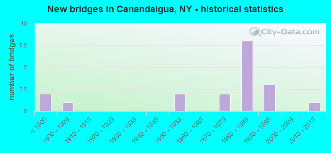
- New bridges - historical statistics
- 2Before 1900
- 11900-1909
- 21950-1959
- 21970-1979
- 81980-1989
- 31990-1999
- 12010-2019
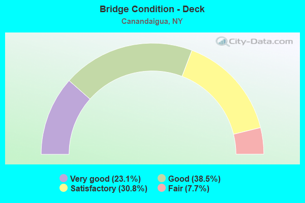
- Bridge Condition - Deck
- 23.1%Very good
- 38.5%Good
- 30.8%Satisfactory
- 7.7%Fair
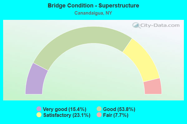
- Bridge Condition - Superstructure
- 15.4%Very good
- 53.8%Good
- 23.1%Satisfactory
- 7.7%Fair
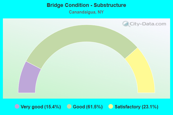
- Bridge Condition - Substructure
- 15.4%Very good
- 61.5%Good
- 23.1%Satisfactory
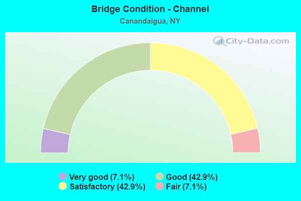
- Bridge Condition - Channel
- 7.1%Very good
- 42.9%Good
- 42.9%Satisfactory
- 7.1%Fair
Find on map >> Show street view
Structure Number: 100184, Location: 1.8MI E JCT RTS 5+20 + 64 (Lat: 42.880492, Lng: -77.353925), Route carried "on" structure: State highway 5, Year Built: 1970, Status: Open, Structure Length: 1.13m (3.71ft), Average Daily Traffic: 7,262 (year 2020), Truck Traffic: 9%, Average Future Daily Traffic: 7,330 (year 2040), Design Load: HS 20, Features Intersected: SCHAFFER CREEK
Minimum Vertical Clearance: 30+ m (98+ ft), Kilometerpoint: 17.393, Lanes on structure: 2, Base Highway Network: Yes, Owner: State Highway Agency, Approaching Roadway Width: 14.3m (46.9ft), Material/Design: Prestressed concrete, Design/Construction: Box Beam or Girders - Multiple, Number Of Spans In Main Unit: 1, Length of Maximum Span: 9.8m (32.2ft), Curb-To-Curb Width: 14.3m (46.9ft), Out-to-Out Width: 15.2m (49.9ft)
Condition: Deck: Satisfactory, Superstructure: Fair, Substructure: Good, Channel: Satisfactory, Operating Rating: 66.2 metric tons, Method Used To Determine Operating Rating: Load Factor (LF), Inventory Rating: 39.0 metric tons, Method Used To Determine Inventory Rating: Load Factor (LF), Structural Evaluation: Somewhat better than minimum adequacy, Deck Geometry: Superior to present desirable criteria, Waterway Adequacy: Somewhat better than minimum adequacy, Approach Roadway Alignment: Equal to present desirable criteria, Length Of Structure Improvement: 1.12m (3.67ft), Designated Inspection Frequency: Every 24 months, Inspection Date: June 2020, Bridge Improvement Cost: $581,000, Roadway Improvement Cost: $340,000, Total Project Cost: $922,000 ( Estimate for 2021), Wearing Surface/Protective System: Wearing Surface: Bituminous, Membrane: Preformed Fabric
Find on map >> Show street view
Structure Number: 100185, Location: 0.1MI W JCT RTS 5+20 +364 (Lat: 42.876558, Lng: -77.250939), Route carried "on" structure: State highway 5, Year Built: 1955, Status: Open, Structure Length: 1.22m (4.00ft), Average Daily Traffic: 24,346 (year 2020), Truck Traffic: 5%, Average Future Daily Traffic: 24,460 (year 2040), Design Load: H 20, Features Intersected: CANANDAIGUAOUTLET
Minimum Vertical Clearance: 30+ m (98+ ft), Kilometerpoint: 26.806, Lanes on structure: 4, Base Highway Network: Yes, Owner: State Highway Agency, Approaching Roadway Width: 15.5m (50.9ft), Skew: 21 degrees, Material/Design: Concrete, Design/Construction: Culvert, Number Of Spans In Main Unit: 2, Length of Maximum Span: 5.5m (18.0ft)
Condition: Channel: Good, Culverts: Good, Operating Rating: 54.4 metric tons, Method Used To Determine Operating Rating: Load Factor (LF), Inventory Rating: 32.7 metric tons, Method Used To Determine Inventory Rating: Load Factor (LF), Structural Evaluation: Better than present minimum criteria, Waterway Adequacy: Meets minimum limits, Approach Roadway Alignment: Better than present minimum criteria, Length Of Structure Improvement: 1.21m (3.97ft), Designated Inspection Frequency: Every 24 months, Inspection Date: August 2020, Bridge Improvement Cost: $586,000, Roadway Improvement Cost: $343,000, Total Project Cost: $930,000 ( Estimate for 2021), Wearing Surface/Protective System: Wearing Surface: Bituminous
Find on map >> Show street view
Structure Number: 100186, Location: .4 MI W JCT US 20 & SH332 (Lat: 42.885608, Lng: -77.287350), Route carried "on" structure: City street , Year Built: 2010, Status: Open, Structure Length: 0.82m (2.69ft), Average Daily Traffic: 4,673 (year 2020), Truck Traffic: 3%, Average Future Daily Traffic: 5,676 (year 2040), Design Load: HS 25 or greater, Features Intersected: SUCKER BROOK, Facility Carried by Structure: WEST AVENUE
Minimum Vertical Clearance: 30+ m (98+ ft), Kilometerpoint: 0.949, Lanes on structure: 2, Owner: City or Municipal Highway Agency, Approaching Roadway Width: 13.4m (44.0ft), Skew: 2 degrees, Material/Design: Concrete, Design/Construction: Culvert, Number Of Spans In Main Unit: 1, Length of Maximum Span: 7.6m (24.9ft), Curb or Sidewalk Widths: Left: 1.5m (4.9ft), Right: 1.5m (4.9ft), Curb-To-Curb Width: 8.5m (27.9ft), Out-to-Out Width: 15.2m (49.9ft)
Condition: Channel: Good, Culverts: Good, Operating Rating: 78.0 metric tons, Method Used To Determine Operating Rating: Field evaluation and documented engineering judgment, Inventory Rating: 40.8 metric tons, Method Used To Determine Inventory Rating: Field evaluation and documented engineering judgment, Structural Evaluation: Better than present minimum criteria, Deck Geometry: Meets minimum limits, Waterway Adequacy: Equal to present minimum criteria, Approach Roadway Alignment: Equal to present desirable criteria, Length Of Structure Improvement: 0.82m (2.69ft), Designated Inspection Frequency: Every 24 months, Inspection Date: July 2020, Bridge Improvement Cost: $225,000, Roadway Improvement Cost: $132,000, Total Project Cost: $357,000 ( Estimate for 2021), Wearing Surface/Protective System: Wearing Surface: Bituminous
Find on map >> Show street view
Structure Number: 104667, Location: 0.4 MI S JCT RTS 20 & 364 (Lat: 42.870592, Lng: -77.251014), Route carried "on" structure: State highway 364, Year Built: 1994, Status: Open, Structure Length: 0.82m (2.69ft), Average Daily Traffic: 6,132 (year 2020), Truck Traffic: 1%, Average Future Daily Traffic: 7,587 (year 2040), Design Load: HS 25 or greater, Features Intersected: FALL BROOK
Minimum Vertical Clearance: 30+ m (98+ ft), Kilometerpoint: 12.582, Lanes on structure: 2, Base Highway Network: Yes, Owner: State Highway Agency, Approaching Roadway Width: 12.2m (40.0ft), Skew: 1 degrees, Material/Design: Concrete, Design/Construction: Frame, Number Of Spans In Main Unit: 1, Length of Maximum Span: 7.6m (24.9ft), Curb or Sidewalk Widths: Left: 1.5m (4.9ft), Right: 1.5m (4.9ft), Curb-To-Curb Width: 12.2m (40.0ft), Out-to-Out Width: 15.8m (51.8ft)
Condition: Deck: Very good, Superstructure: Good, Substructure: Very good, Channel: Satisfactory, Operating Rating: 59.0 metric tons, Method Used To Determine Operating Rating: Load and Resistance Factor Rating (LRFR) rating reported by rating factor(RF) method using HL-93 loadings, Inventory Rating: 45.7 metric tons, Method Used To Determine Inventory Rating: Load and Resistance Factor Rating (LRFR) rating reported by rating factor(RF) method using HL-93 loadings, Structural Evaluation: Better than present minimum criteria, Deck Geometry: Somewhat better than minimum adequacy, Waterway Adequacy: Somewhat better than minimum adequacy, Approach Roadway Alignment: Equal to present desirable criteria, Length Of Structure Improvement: 0.82m (2.69ft), Designated Inspection Frequency: Every 24 months, Inspection Date: June 2020, Bridge Improvement Cost: $376,000, Roadway Improvement Cost: $220,000, Total Project Cost: $596,000 ( Estimate for 2021), Wearing Surface/Protective System: Wearing Surface: Bituminous
Find on map >> Show street view
Structure Number: 107119, Location: 0.5 MI S JCT RT21&RTS5&20 (Lat: 42.877856, Lng: -77.278167), Route carried "on" structure: Bypass State highway 5, Year Built: 1980, Status: Open, Structure Length: 2.47m (8.10ft), Average Daily Traffic: 13,014 (year 2019), Truck Traffic: 6%, Average Future Daily Traffic: 13,574 (year 2040), Design Load: HS 20, Features Intersected: SUCKER BROOK
Minimum Vertical Clearance: 30+ m (98+ ft), Kilometerpoint: 24.505, Lanes on structure: 3, Base Highway Network: Yes, Owner: State Highway Agency, Approaching Roadway Width: 15.8m (51.8ft), Skew: 20 degrees, Material/Design: Steel, Design/Construction: Stringer/Multi-beam, Number Of Spans In Main Unit: 1, Length of Maximum Span: 23.4m (76.8ft), Curb-To-Curb Width: 18.1m (59.4ft), Out-to-Out Width: 18.7m (61.4ft)
Condition: Deck: Very good, Superstructure: Good, Substructure: Satisfactory, Channel: Good, Operating Rating: 54.1 metric tons, Method Used To Determine Operating Rating: Load and Resistance Factor Rating (LRFR) rating reported by rating factor(RF) method using HL-93 loadings, Inventory Rating: 41.8 metric tons, Method Used To Determine Inventory Rating: Load and Resistance Factor Rating (LRFR) rating reported by rating factor(RF) method using HL-93 loadings, Structural Evaluation: Equal to present minimum criteria, Deck Geometry: Better than present minimum criteria, Waterway Adequacy: Equal to present desirable criteria, Approach Roadway Alignment: Equal to present desirable criteria, Length Of Structure Improvement: 2.46m (8.07ft), Designated Inspection Frequency: Every 24 months, Inspection Date: September 2020, Bridge Improvement Cost: $1,400,000, Roadway Improvement Cost: $820,000, Total Project Cost: $2,220,000 ( Estimate for 2021), Deck Structure Type: Concrete Cast-file-Place, Wearing Surface/Protective System: Wearing Surface: Bituminous, Deck Protection: Epoxy Coated Reinforcing
Find on map >> Show street view
Structure Number: 10712, Location: 0.8MI SW JCT RT21&RTS5&20 (Lat: 42.875358, Lng: -77.283400), Route carried "on" structure: Bypass Other road 5, Year Built: 1980, Status: Open, Structure Length: 4.88m (16.01ft), Average Daily Traffic: 13,014 (year 2019), Truck Traffic: 6%, Average Future Daily Traffic: 13,574 (year 2040), Design Load: HS 20, Features Intersected: W LAKE RD (CR16)
Minimum Vertical Clearance: 30+ m (98+ ft), Kilometerpoint: 24.006, Lanes on structure: 3, Lanes under structure: 2, Base Highway Network: Yes, Owner: State Highway Agency, Approaching Roadway Width: 15.5m (50.9ft), Skew: 4 degrees, Material/Design: Steel, Design/Construction: Stringer/Multi-beam, Number Of Spans In Main Unit: 1, Length of Maximum Span: 46.9m (153.9ft), Curb-To-Curb Width: 15.5m (50.9ft), Out-to-Out Width: 16.5m (54.1ft)
Condition: Deck: Satisfactory, Superstructure: Good, Substructure: Good, Operating Rating: 74.4 metric tons, Method Used To Determine Operating Rating: Load Factor (LF), Inventory Rating: 39.9 metric tons, Method Used To Determine Inventory Rating: Load Factor (LF), Structural Evaluation: Better than present minimum criteria, Deck Geometry: Somewhat better than minimum adequacy, Underclear: Somewhat better than minimum adequacy, Approach Roadway Alignment: Equal to present desirable criteria, Length Of Structure Improvement: 4.87m (15.98ft), Designated Inspection Frequency: Every 24 months, Inspection Date: October 2020, Bridge Improvement Cost: $2,410,000, Roadway Improvement Cost: $1,411,000, Total Project Cost: $3,822,000 ( Estimate for 2021), Deck Structure Type: Concrete Cast-file-Place, Wearing Surface/Protective System: Wearing Surface: Bituminous, Deck Protection: Epoxy Coated Reinforcing
Find on map >> Show street view
Structure Number: 221161, Location: CITY OF CANANDAIGUA (Lat: 42.888475, Lng: -77.292228), Route carried "on" structure: City street , Year Built: 1986, Status: Open, Structure Length: 0.73m (2.40ft), Average Daily Traffic: 4,873 (year 2017), Truck Traffic: 2%, Average Future Daily Traffic: 6,029 (year 2040), Design Load: HS 20, Features Intersected: SUCKER BROOK, Facility Carried by Structure: NORTH PEARL ST
Minimum Vertical Clearance: 30+ m (98+ ft), Kilometerpoint: 0.467, Lanes on structure: 2, Owner: City or Municipal Highway Agency, Approaching Roadway Width: 9.4m (30.8ft), Skew: 1 degrees, Material/Design: Concrete, Design/Construction: Slab, Number Of Spans In Main Unit: 1, Length of Maximum Span: 6.7m (22.0ft), Curb or Sidewalk Widths: Left: 5.6m (18.4ft), Right: 0.0m, Curb-To-Curb Width: 9.4m (30.8ft), Out-to-Out Width: 16.2m (53.1ft)
Condition: Deck: Good, Superstructure: Good, Substructure: Good, Channel: Good, Operating Rating: 41.1 metric tons, Method Used To Determine Operating Rating: Load and Resistance Factor Rating (LRFR) rating reported by rating factor(RF) method using HL-93 loadings, Inventory Rating: 31.8 metric tons, Method Used To Determine Inventory Rating: Load and Resistance Factor Rating (LRFR) rating reported by rating factor(RF) method using HL-93 loadings, Structural Evaluation: Better than present minimum criteria, Deck Geometry: Meets minimum limits, Waterway Adequacy: Equal to present minimum criteria, Approach Roadway Alignment: Equal to present desirable criteria, Length Of Structure Improvement: 0.73m (2.40ft), Designated Inspection Frequency: Every 24 months, Inspection Date: April 2021, Bridge Improvement Cost: $390,000, Roadway Improvement Cost: $228,000, Total Project Cost: $618,000 ( Estimate for 2021), Deck Structure Type: Concrete Cast-file-Place, Wearing Surface/Protective System: Wearing Surface: Monolithic Concrete, Deck Protection: Epoxy Coated Reinforcing
Find on map >> Show street view
Structure Number: 221164, Location: CITY OF CANANDAIGUA (Lat: 42.885192, Lng: -77.285567), Route carried "on" structure: City street , Year Built: 1986, Status: Open, Structure Length: 0.76m (2.49ft), Average Daily Traffic: 930 (year 2017), Truck Traffic: 1%, Average Future Daily Traffic: 1,302 (year 2037), Design Load: HS 20, Features Intersected: SUCKER BROOK, Facility Carried by Structure: CHAPIN STREET
Minimum Vertical Clearance: 30+ m (98+ ft), Kilometerpoint: 0.515, Lanes on structure: 2, Owner: City or Municipal Highway Agency, Approaching Roadway Width: 7.3m (24.0ft), Skew: 1 degrees, Material/Design: Concrete, Design/Construction: Slab, Number Of Spans In Main Unit: 1, Length of Maximum Span: 6.7m (22.0ft), Curb or Sidewalk Widths: Left: 2.0m (6.6ft), Right: 2.0m (6.6ft), Curb-To-Curb Width: 7.3m (24.0ft), Out-to-Out Width: 11.3m (37.1ft)
Condition: Deck: Good, Superstructure: Good, Substructure: Good, Channel: Fair, Operating Rating: 52.6 metric tons, Method Used To Determine Operating Rating: Load Factor (LF), Inventory Rating: 31.8 metric tons, Method Used To Determine Inventory Rating: Load Factor (LF), Structural Evaluation: Better than present minimum criteria, Deck Geometry: Meets minimum limits, Waterway Adequacy: Better than present minimum criteria, Approach Roadway Alignment: Equal to present desirable criteria, Length Of Structure Improvement: 0.76m (2.49ft), Designated Inspection Frequency: Every 24 months, Inspection Date: March 2021, Bridge Improvement Cost: $250,000, Roadway Improvement Cost: $147,000, Total Project Cost: $397,000 ( Estimate for 2021), Deck Structure Type: Concrete Cast-file-Place, Wearing Surface/Protective System: Wearing Surface: Bituminous, Deck Protection: Epoxy Coated Reinforcing
Find on map >> Show street view
Structure Number: 221167, Location: CITY OF CANANDAIGUA (Lat: 42.879119, Lng: -77.279144), Route carried "on" structure: City street , Year Built: 1958, Year Reconstructed: 1983, Status: Open, Structure Length: 0.79m (2.59ft), Average Daily Traffic: 6,945 (year 2017), Truck Traffic: 3%, Average Future Daily Traffic: 8,593 (year 2040), Design Load: HS 20, Features Intersected: SUCKER BROOK, Facility Carried by Structure: PARRISH STREET
Minimum Vertical Clearance: 30+ m (98+ ft), Kilometerpoint: 1.158, Lanes on structure: 2, Owner: City or Municipal Highway Agency, Approaching Roadway Width: 9.1m (29.9ft), Material/Design: Prestressed concrete, Design/Construction: Box Beam or Girders - Multiple, Number Of Spans In Main Unit: 1, Length of Maximum Span: 7.3m (24.0ft), Curb or Sidewalk Widths: Left: 1.7m (5.6ft), Right: 0.0m, Curb-To-Curb Width: 9.1m (29.9ft), Out-to-Out Width: 11.8m (38.7ft)
Condition: Deck: Very good, Superstructure: Very good, Substructure: Good, Channel: Satisfactory, Operating Rating: 71.7 metric tons, Method Used To Determine Operating Rating: Load Factor (LF), Inventory Rating: 39.0 metric tons, Method Used To Determine Inventory Rating: Load Factor (LF), Structural Evaluation: Better than present minimum criteria, Deck Geometry: High priority of corrective action, Waterway Adequacy: Equal to present minimum criteria, Approach Roadway Alignment: Equal to present desirable criteria, Length Of Structure Improvement: 0.79m (2.59ft), Designated Inspection Frequency: Every 24 months, Inspection Date: March 2021, Bridge Improvement Cost: $341,000, Roadway Improvement Cost: $200,000, Total Project Cost: $541,000 ( Estimate for 2021), Wearing Surface/Protective System: Wearing Surface: Bituminous
Find on map >> Show street view
Structure Number: 225784, Location: CITY OF CANANDAIGUA (Lat: 42.886642, Lng: -77.265864), Route carried "on" structure: City street , Year Built: 1986, Status: Open, Structure Length: 1.07m (3.51ft), Average Daily Traffic: 3,060 (year 2020), Truck Traffic: 5%, Average Future Daily Traffic: 3,786 (year 2040), Design Load: HS 20, Features Intersected: FEEDER CANAL, Facility Carried by Structure: SALTONSTALL STREET
Minimum Vertical Clearance: 30+ m (98+ ft), Kilometerpoint: 1.142, Lanes on structure: 2, Owner: City or Municipal Highway Agency, Approaching Roadway Width: 9.8m (32.2ft), Material/Design: Prestressed concrete, Design/Construction: Box Beam or Girders - Multiple, Number Of Spans In Main Unit: 1, Length of Maximum Span: 9.1m (29.9ft), Curb-To-Curb Width: 9.8m (32.2ft), Out-to-Out Width: 10.5m (34.4ft)
Condition: Deck: Fair, Superstructure: Satisfactory, Substructure: Satisfactory, Channel: Good, Operating Rating: 89.4 metric tons, Method Used To Determine Operating Rating: Load and Resistance Factor Rating (LRFR) rating reported by rating factor(RF) method using HL-93 loadings, Inventory Rating: 69.0 metric tons, Method Used To Determine Inventory Rating: Load and Resistance Factor Rating (LRFR) rating reported by rating factor(RF) method using HL-93 loadings, Structural Evaluation: Equal to present minimum criteria, Deck Geometry: Meets minimum limits, Waterway Adequacy: Equal to present minimum criteria, Approach Roadway Alignment: Equal to present desirable criteria, Length Of Structure Improvement: 1.06m (3.48ft), Designated Inspection Frequency: Every 24 months, Inspection Date: May 2021, Bridge Improvement Cost: $421,000, Roadway Improvement Cost: $247,000, Total Project Cost: $668,000 ( Estimate for 2021), Deck Structure Type: Concrete Cast-file-Place, Wearing Surface/Protective System: Wearing Surface: Integral Concrete, Deck Protection: Epoxy Coated Reinforcing
Find on map >> Show street view
Structure Number: 226718, Location: CITY OF CANANDAIGUA (Lat: 42.883517, Lng: -77.283075), Route carried "on" structure: City street , Year Built: 1986, Status: Open, Structure Length: 0.73m (2.40ft), Average Daily Traffic: 1,737 (year 2020), Truck Traffic: 3%, Average Future Daily Traffic: 2,110 (year 2040), Design Load: HS 20, Features Intersected: SUCKER BROOK, Facility Carried by Structure: BRISTOL STREET
Minimum Vertical Clearance: 30+ m (98+ ft), Kilometerpoint: 1.126, Lanes on structure: 2, Owner: City or Municipal Highway Agency, Approaching Roadway Width: 7.3m (24.0ft), Material/Design: Concrete, Design/Construction: Slab, Number Of Spans In Main Unit: 1, Length of Maximum Span: 6.7m (22.0ft), Curb or Sidewalk Widths: Left: 2.0m (6.6ft), Right: 2.0m (6.6ft), Curb-To-Curb Width: 7.3m (24.0ft), Out-to-Out Width: 11.9m (39.0ft)
Condition: Deck: Satisfactory, Superstructure: Satisfactory, Substructure: Good, Channel: Satisfactory, Operating Rating: 58.0 metric tons, Method Used To Determine Operating Rating: Load and Resistance Factor Rating (LRFR) rating reported by rating factor(RF) method using HL-93 loadings, Inventory Rating: 44.7 metric tons, Method Used To Determine Inventory Rating: Load and Resistance Factor Rating (LRFR) rating reported by rating factor(RF) method using HL-93 loadings, Structural Evaluation: Equal to present minimum criteria, Deck Geometry: Meets minimum limits, Waterway Adequacy: Equal to present minimum criteria, Approach Roadway Alignment: Equal to present desirable criteria, Length Of Structure Improvement: 0.73m (2.40ft), Designated Inspection Frequency: Every 24 months, Inspection Date: March 2021, Bridge Improvement Cost: $383,000, Roadway Improvement Cost: $224,000, Total Project Cost: $608,000 ( Estimate for 2021), Wearing Surface/Protective System: Wearing Surface: Bituminous
Find on map >> Show street view
Structure Number: 226785, Location: CITY OF CANANDAIGUA (Lat: 42.887758, Lng: -77.289572), Route carried "on" structure: City street , Year Built: 1988, Status: Open, Structure Length: 0.70m (2.30ft), Average Daily Traffic: 2,239 (year 2017), Truck Traffic: 2%, Average Future Daily Traffic: 3,135 (year 2037), Design Load: HS 20, Features Intersected: SUCKER BROOK, Facility Carried by Structure: W. GIBSON STREET
Minimum Vertical Clearance: 30+ m (98+ ft), Kilometerpoint: 0.402, Lanes on structure: 2, Owner: City or Municipal Highway Agency, Approaching Roadway Width: 7.3m (24.0ft), Material/Design: Concrete, Design/Construction: Slab, Number Of Spans In Main Unit: 1, Length of Maximum Span: 6.4m (21.0ft), Curb or Sidewalk Widths: Left: 4.0m (13.1ft), Right: 3.7m (12.1ft), Curb-To-Curb Width: 7.3m (24.0ft), Out-to-Out Width: 15.6m (51.2ft)
Condition: Deck: Good, Superstructure: Good, Substructure: Good, Channel: Good, Operating Rating: 22.4 metric tons, Method Used To Determine Operating Rating: Load and Resistance Factor Rating (LRFR) rating reported by rating factor(RF) method using HL-93 loadings, Inventory Rating: 17.2 metric tons, Method Used To Determine Inventory Rating: Load and Resistance Factor Rating (LRFR) rating reported by rating factor(RF) method using HL-93 loadings, Structural Evaluation: Meets minimum limits, Deck Geometry: High priority of replacement, Waterway Adequacy: Better than present minimum criteria, Approach Roadway Alignment: Equal to present desirable criteria, Length Of Structure Improvement: 0.70m (2.30ft), Designated Inspection Frequency: Every 24 months, Inspection Date: March 2021, Bridge Improvement Cost: $395,000, Roadway Improvement Cost: $231,000, Total Project Cost: $626,000 ( Estimate for 2021), Wearing Surface/Protective System: Wearing Surface: Bituminous
Find on map >> Show street view
Structure Number: 226827, Location: 1/4M S OF INT RT 332-5&20 (Lat: 42.875414, Lng: -77.261444), Route carried "on" structure: City street , Year Built: 1990, Status: Open, Structure Length: 4.08m (13.39ft), Average Daily Traffic: 10,765 (year 2020), Truck Traffic: 4%, Average Future Daily Traffic: 13,319 (year 2040), Design Load: HS 20, Features Intersected: CANANDAIGUA OUTLE, Facility Carried by Structure: LAKESHORE DRIVE
Minimum Vertical Clearance: 30+ m (98+ ft), Kilometerpoint: 0.965, Lanes on structure: 2, Owner: City or Municipal Highway Agency, Approaching Roadway Width: 8.5m (27.9ft), Skew: 2 degrees, Material/Design: Steel, Design/Construction: Stringer/Multi-beam, Number Of Spans In Main Unit: 1, Length of Maximum Span: 40.5m (132.9ft), Curb or Sidewalk Widths: Left: 0.0m, Right: 1.2m (3.9ft), Curb-To-Curb Width: 8.5m (27.9ft), Out-to-Out Width: 10.5m (34.4ft)
Condition: Deck: Good, Superstructure: Good, Substructure: Good, Channel: Very good, Operating Rating: 48.9 metric tons, Method Used To Determine Operating Rating: Load and Resistance Factor Rating (LRFR) rating reported by rating factor(RF) method using HL-93 loadings, Inventory Rating: 37.9 metric tons, Method Used To Determine Inventory Rating: Load and Resistance Factor Rating (LRFR) rating reported by rating factor(RF) method using HL-93 loadings, Structural Evaluation: Better than present minimum criteria, Deck Geometry: High priority of replacement, Waterway Adequacy: Equal to present minimum criteria, Approach Roadway Alignment: Equal to present desirable criteria, Length Of Structure Improvement: 4.08m (13.39ft), Designated Inspection Frequency: Every 24 months, Inspection Date: April 2021, Bridge Improvement Cost: $1,315,000, Roadway Improvement Cost: $770,000, Total Project Cost: $2,085,000 ( Estimate for 2021), Deck Structure Type: Concrete Cast-file-Place, Wearing Surface/Protective System: Wearing Surface: Integral Concrete, Deck Protection: Epoxy Coated Reinforcing
Find on map >> Show street view
Structure Number: 331866, Location: 2.0 MI NE OF CANANDIAGUA (Lat: 42.901725, Lng: -77.246542), Route carried "on" structure: County highway , Year Built: 1991, Status: Open, Structure Length: 1.95m (6.40ft), Average Daily Traffic: 7,407 (year 2020), Truck Traffic: 4%, Average Future Daily Traffic: 9,164 (year 2040), Design Load: HS 20, Features Intersected: CANANDAIGUA OUTLE, Facility Carried by Structure: COUNTY ROAD 4
Minimum Vertical Clearance: 30+ m (98+ ft), Kilometerpoint: 1.754, Lanes on structure: 2, Owner: County Highway Agency, Approaching Roadway Width: 10.1m (33.1ft), Skew: 1 degrees, Material/Design: Prestressed concrete, Design/Construction: Box Beam or Girders - Multiple, Number Of Spans In Main Unit: 1, Length of Maximum Span: 18.8m (61.7ft), Curb-To-Curb Width: 12.3m (40.4ft), Out-to-Out Width: 12.6m (41.3ft)
Condition: Deck: Good, Superstructure: Very good, Substructure: Very good, Channel: Satisfactory, Operating Rating: 59.0 metric tons, Method Used To Determine Operating Rating: Load Factor (LF), Inventory Rating: 34.5 metric tons, Method Used To Determine Inventory Rating: Load Factor (LF), Structural Evaluation: Equal to present desirable criteria, Deck Geometry: Somewhat better than minimum adequacy, Waterway Adequacy: Superior to present desirable criteria, Approach Roadway Alignment: Equal to present desirable criteria, Length Of Structure Improvement: 1.95m (6.40ft), Designated Inspection Frequency: Every 24 months, Inspection Date: July 2020, Bridge Improvement Cost: $687,000, Roadway Improvement Cost: $402,000, Total Project Cost: $1,089,000 ( Estimate for 2021), Wearing Surface/Protective System: Wearing Surface: Bituminous, Membrane: Other
Find on map >> Show street view
Structure Number: 331877, Location: 1 MI EAST OF CANANDAIGUA (Lat: 42.888289, Lng: -77.258628), Route carried "on" structure: County highway , Year Built: 1977, Status: Open, Structure Length: 1.92m (6.30ft), Average Daily Traffic: 3,127 (year 2020), Truck Traffic: 6%, Average Future Daily Traffic: 3,869 (year 2040), Design Load: HS 20, Features Intersected: CANANDAIGUA OUTLT, Facility Carried by Structure: COUNTY ROAD 46
Minimum Vertical Clearance: 30+ m (98+ ft), Kilometerpoint: 0.193, Lanes on structure: 2, Owner: County Highway Agency, Approaching Roadway Width: 10.4m (34.1ft), Material/Design: Prestressed concrete, Design/Construction: Box Beam or Girders - Multiple, Number Of Spans In Main Unit: 1, Length of Maximum Span: 18.2m (59.7ft), Curb-To-Curb Width: 12.0m (39.4ft), Out-to-Out Width: 13.1m (43.0ft)
Condition: Deck: Satisfactory, Superstructure: Satisfactory, Substructure: Satisfactory, Channel: Satisfactory, Operating Rating: 92.5 metric tons, Method Used To Determine Operating Rating: Load Factor (LF), Inventory Rating: 55.3 metric tons, Method Used To Determine Inventory Rating: Load Factor (LF), Structural Evaluation: Equal to present minimum criteria, Deck Geometry: Somewhat better than minimum adequacy, Waterway Adequacy: Equal to present desirable criteria, Approach Roadway Alignment: Equal to present desirable criteria, Length Of Structure Improvement: 1.92m (6.30ft), Designated Inspection Frequency: Every 24 months, Inspection Date: April 2021, Bridge Improvement Cost: $725,000, Roadway Improvement Cost: $425,000, Total Project Cost: $1,150,000 ( Estimate for 2021), Wearing Surface/Protective System: Wearing Surface: Bituminous
Find on map >> Show street view
Structure Number: 10712, Location: 0.8MI SW JCT RT21&RTS5&20 (Lat: 42.875358, Lng: -77.283400), Route carried "under" structure: County highway , Year Built: 1980, Structure Length: 0. m, Average Daily Traffic: 3,000 (year 1980), Features Intersected: W LAKE RD (CR16), Facility Carried by Structure: RTE 5
Minimum Vertical Clearance: 4.55m (14.93ft), Kilometerpoint: 0.000, Lanes on structure: 3, Lanes under structure: 2, Material/Design: Steel, Design/Construction: Stringer/Multi-beam, Length of Maximum Span: 46.9m (153.9ft)
Find on map >> Show street view
Structure Number: 700188, Location: 0.1MI SW JCT 5+20 + 332 (Lat: 42.887461, Lng: -77.282597), Route carried "under" structure: Alternate City street , Year Built: 1907, Structure Length: 0. m, Average Daily Traffic: 4,673 (year 2020), Truck Traffic: 3%, Features Intersected: WEST AVENUE, Facility Carried by Structure: FINGER LAKES
Minimum Vertical Clearance: 3.96m (12.99ft), Kilometerpoint: 0.949, Lanes under structure: 2, Material/Design: Steel, Design/Construction: Girder and Floorbeam System, Length of Maximum Span: 20.4m (66.9ft)
Find on map >> Show street view
Structure Number: 7707081, Location: CITY OF CANANDAIGUA (Lat: 42.888203, Lng: -77.284631), Route carried "under" structure: City street , Year Built: 1885, Structure Length: 0. m, Features Intersected: GRIEG AVENUE, Facility Carried by Structure: FINGER LAKES
Minimum Vertical Clearance: 3.73m (12.24ft), Kilometerpoint: 0.000, Lanes under structure: 2, Material/Design: Steel, Length of Maximum Span: 13.7m (44.9ft)
Find on map >> Show street view
Structure Number: 7707082, Location: CITY OF CANANDAIGUA (Lat: 42.888231, Lng: -77.284553), Route carried "under" structure: City street , Year Built: 1885, Structure Length: 0. m, Features Intersected: GRIEG AVENUE, Facility Carried by Structure: FINGER LKS SVC RD
Minimum Vertical Clearance: 3.73m (12.24ft), Kilometerpoint: 0.080, Lanes under structure: 2, Material/Design: Steel, Length of Maximum Span: 13.7m (44.9ft)