Bridge Statistics for Camp Springs, Maryland (MD)
Condition, Traffic, Stress, Structural Evaluation, Project Costs
- National Bridge Inventory (NBI) Statistics
- 14Number of bridges
- 157ft / 48.5mTotal length
- $4,471,000Total costs
- 1,128,312Total average daily traffic
- 65,826Total average daily truck traffic
- National Bridge Inventory (NBI) Registered Bridges for Camp Springs
- No street view available for this location
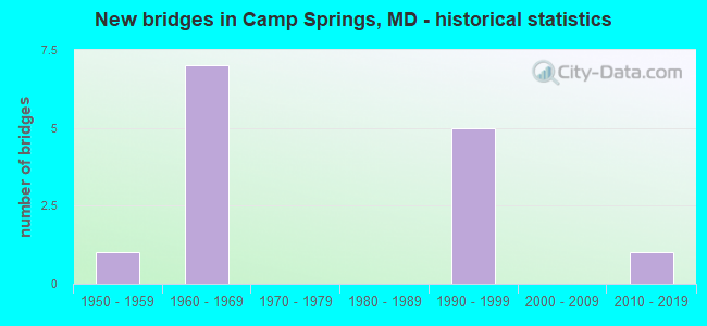
- New bridges - historical statistics
- 11950-1959
- 71960-1969
- 51990-1999
- 12010-2019

- Reconstructed bridges - Historical Statistics
- 11990-1999
- 12000-2009


- Bridge Condition - Superstructure
- 25.0%Very good
- 50.0%Good
- 25.0%Satisfactory

- Bridge Condition - Substructure
- 50.0%Very good
- 50.0%Fair

- Bridge Condition - Channel
- 25.0%Good
- 75.0%Satisfactory

- Bridge Condition - Culverts
- 25.0%Good
- 50.0%Satisfactory
- 25.0%Poor
Find on map >> Show street view
Structure Number: 10000016001202, Location: 0.17 MILE N OF MD 967C (Lat: 38.827289, Lng: -76.927061), Route carried "on" structure: State highway 5, Year Built: 1950, Status: Open, Structure Length: 6.89m (22.60ft), Average Daily Traffic: 66,772 (year 2009), Truck Traffic: 8%, Average Future Daily Traffic: 79,848 (year 2026), Design Load: H 20, Features Intersected: HENSON CREEK
Minimum Vertical Clearance: 30+ m (98+ ft), Kilometerpoint: 20.322, Lanes on structure: 4, Base Highway Network: Yes, Owner: State Highway Agency, Approaching Roadway Width: 36.0m (118.1ft), Skew: 2 degrees, Material/Design: Concrete, Design/Construction: Culvert, Length of Maximum Span: 6.1m (20.0ft)
Condition: Channel: Satisfactory, Culverts: Satisfactory, Structural Evaluation: Equal to present minimum criteria, Waterway Adequacy: Better than present minimum criteria, Approach Roadway Alignment: Equal to present desirable criteria, Designated Inspection Frequency: Every 24 months, Other Special Inspection Frequency: Every 12 months, Inspection Date: March 2021, Other Special Inspection Date: March 2021
Find on map >> Show street view
Structure Number: 10000016016301, Location: 0.53 MILE NORTH OF MD 337 (Lat: 38.817517, Lng: -76.901989), Route carried "on" structure: County highway 127, Year Built: 1963, Year Reconstructed: 2006, Status: Open, Structure Length: 9.21m (30.22ft), Average Daily Traffic: 8,105 (year 2016), Truck Traffic: 5%, Average Future Daily Traffic: 9,050 (year 2038), Design Load: H 20, Features Intersected: IS 95, Facility Carried by Structure: AUTH RD
Minimum Vertical Clearance: 30+ m (98+ ft), Kilometerpoint: 0.901, Lanes on structure: 2, Lanes under structure: 8, Owner: State Highway Agency, Approaching Roadway Width: 13.4m (44.0ft), Skew: 3 degrees, Material/Design: Steel, Design/Construction: Stringer/Multi-beam, Number Of Spans In Main Unit: 2, Number Of Approach Spans: 2, Length of Maximum Span: 33.2m (108.9ft), Curb or Sidewalk Widths: Left: 1.6m (5.2ft), Right: 1.6m (5.2ft), Curb-To-Curb Width: 12.2m (40.0ft), Out-to-Out Width: 16.1m (52.8ft)
Condition: Deck: Good, Superstructure: Good, Substructure: Fair, Operating Rating: 76.2 metric tons, Method Used To Determine Operating Rating: Load Factor (LF), Inventory Rating: 45.8 metric tons, Method Used To Determine Inventory Rating: Load Factor (LF), Structural Evaluation: Somewhat better than minimum adequacy, Deck Geometry: Somewhat better than minimum adequacy, Underclear: Meets minimum limits, Approach Roadway Alignment: Equal to present desirable criteria, Length Of Structure Improvement: 9.21m (30.22ft), Designated Inspection Frequency: Every 24 months, Inspection Date: January 2021, Bridge Improvement Cost: $946,000, Roadway Improvement Cost: $95,000, Total Project Cost: $1,041,000, Deck Structure Type: Concrete Cast-file-Place, Wearing Surface/Protective System: Wearing Surface: Bituminous
Find on map >> Show street view
Structure Number: 10000016016401, Location: 2.97 MILES N OF MD 414 (Lat: 38.819422, Lng: -76.919342), Route carried "on" structure: Interstate 95, Year Built: 1963, Year Reconstructed: 1997, Status: Open, Structure Length: 10.45m (34.28ft), Average Daily Traffic: 177,270 (year 2009), Truck Traffic: 8%, Average Future Daily Traffic: 186,444 (year 2026), Design Load: HS 20, Features Intersected: MD 5
Minimum Vertical Clearance: 30+ m (98+ ft), Kilometerpoint: 11.746, Lanes on structure: 10, Lanes under structure: 4, Base Highway Network: Yes, Owner: State Highway Agency, Approaching Roadway Width: 62.8m (206.0ft), Skew: 34 degrees, Material/Design: Steel, Design/Construction: Stringer/Multi-beam, Number Of Spans In Main Unit: 2, Number Of Approach Spans: 2, Length of Maximum Span: 33.5m (109.9ft), Curb-To-Curb Width: 54.5m (178.8ft), Out-to-Out Width: 56.6m (185.7ft)
Condition: Deck: Good, Superstructure: Satisfactory, Substructure: Fair, Operating Rating: 84.4 metric tons, Method Used To Determine Operating Rating: Load Factor (LF), Inventory Rating: 50.8 metric tons, Method Used To Determine Inventory Rating: Load Factor (LF), Structural Evaluation: Somewhat better than minimum adequacy, Deck Geometry: Superior to present desirable criteria, Underclear: High priority of replacement, Approach Roadway Alignment: Equal to present desirable criteria, Length Of Structure Improvement: 10.15m (33.30ft), Designated Inspection Frequency: Every 24 months, Inspection Date: November 2020, Bridge Improvement Cost: $2,845,000, Roadway Improvement Cost: $284,000, Total Project Cost: $3,130,000, Deck Structure Type: Concrete Cast-file-Place, Wearing Surface/Protective System: Wearing Surface: Monolithic Concrete
Find on map >> Show street view
Structure Number: 10000016016502, Location: 0.67 MILE SOUTH OF MD 5 (Lat: 38.818494, Lng: -76.931306), Route carried "on" structure: Interstate 95, Year Built: 1963, Status: Open, Structure Length: 9.05m (29.69ft), Average Daily Traffic: 143,828 (year 2009), Truck Traffic: 8%, Average Future Daily Traffic: 147,712 (year 2026), Design Load: HS 20, Features Intersected: HENSON CREEK
Minimum Vertical Clearance: 30+ m (98+ ft), Kilometerpoint: 10.668, Lanes on structure: 8, Base Highway Network: Yes, Owner: State Highway Agency, Approaching Roadway Width: 53.0m (173.9ft), Skew: 2 degrees, Material/Design: Concrete, Design/Construction: Culvert, Length of Maximum Span: 4.6m (15.1ft)
Condition: Channel: Good, Culverts: Satisfactory, Structural Evaluation: Equal to present minimum criteria, Waterway Adequacy: Better than present minimum criteria, Approach Roadway Alignment: Equal to present desirable criteria, Designated Inspection Frequency: Every 24 months, Inspection Date: April 2021
Find on map >> Show street view
Structure Number: 100000160253011, Location: 1.27 MILES SOUTH OF IS 95 (Lat: 38.804781, Lng: -76.905644), Route carried "on" structure: State highway 5, Year Built: 1996, Status: Open, Structure Length: 5.49m (18.01ft), Average Daily Traffic: 106,842 (year 2009), Truck Traffic: 7%, Average Future Daily Traffic: 63,952 (year 2026), Design Load: HS 25 or greater, Features Intersected: MD 337 (ALLENTOWN ROAD)
Minimum Vertical Clearance: 30+ m (98+ ft), Kilometerpoint: 17.157, Lanes on structure: 3, Lanes under structure: 6, Base Highway Network: Yes, Owner: State Highway Agency, Approaching Roadway Width: 15.9m (52.2ft), Material/Design: Steel, Design/Construction: Stringer/Multi-beam, Number Of Spans In Main Unit: 1, Length of Maximum Span: 53.3m (174.9ft), Curb-To-Curb Width: 15.9m (52.2ft), Out-to-Out Width: 17.1m (56.1ft)
Condition: Deck: Good, Superstructure: Good, Substructure: Very good, Operating Rating: 88.0 metric tons, Method Used To Determine Operating Rating: Load Factor (LF), Inventory Rating: 53.1 metric tons, Method Used To Determine Inventory Rating: Load Factor (LF), Structural Evaluation: Better than present minimum criteria, Deck Geometry: Somewhat better than minimum adequacy, Underclear: Somewhat better than minimum adequacy, Approach Roadway Alignment: Equal to present desirable criteria, Designated Inspection Frequency: Every 24 months, Inspection Date: April 2021, Deck Structure Type: Concrete Cast-file-Place, Wearing Surface/Protective System: Wearing Surface: Monolithic Concrete, Deck Protection: Epoxy Coated Reinforcing
Find on map >> Show street view
Structure Number: 100000160253012, Location: 1.27 MILES SOUTH OF IS 95 (Lat: 38.805083, Lng: -76.906169), Route carried "on" structure: State highway 5, Year Built: 1996, Status: Open, Structure Length: 5.49m (18.01ft), Average Daily Traffic: 106,842 (year 2009), Truck Traffic: 7%, Average Future Daily Traffic: 63,952 (year 2026), Design Load: HS 25 or greater, Features Intersected: MD 337 (ALLENTOWN ROAD)
Minimum Vertical Clearance: 30+ m (98+ ft), Kilometerpoint: 17.157, Lanes on structure: 3, Lanes under structure: 6, Base Highway Network: Yes, Owner: State Highway Agency, Approaching Roadway Width: 15.9m (52.2ft), Material/Design: Steel, Design/Construction: Stringer/Multi-beam, Number Of Spans In Main Unit: 1, Length of Maximum Span: 53.3m (174.9ft), Curb-To-Curb Width: 15.9m (52.2ft), Out-to-Out Width: 17.1m (56.1ft)
Condition: Deck: Good, Superstructure: Very good, Substructure: Very good, Operating Rating: 88.0 metric tons, Method Used To Determine Operating Rating: Load Factor (LF), Inventory Rating: 53.1 metric tons, Method Used To Determine Inventory Rating: Load Factor (LF), Structural Evaluation: Equal to present desirable criteria, Deck Geometry: Somewhat better than minimum adequacy, Underclear: Somewhat better than minimum adequacy, Approach Roadway Alignment: Equal to present desirable criteria, Designated Inspection Frequency: Every 24 months, Inspection Date: April 2021, Deck Structure Type: Concrete Cast-file-Place, Wearing Surface/Protective System: Wearing Surface: Monolithic Concrete, Deck Protection: Epoxy Coated Reinforcing
Find on map >> Show street view
Structure Number: 200000P-030803, Location: .11 MI S OF BRINKLEY ROAD (Lat: 38.799939, Lng: -76.927414), Route carried "on" structure: County highway 123, Year Built: 1964, Status: Open, Structure Length: 0.67m (2.20ft), Average Daily Traffic: 16,712 (year 2019), Truck Traffic: 10%, Average Future Daily Traffic: 24,840 (year 2039), Design Load: H 20, Features Intersected: TRIB TO HENSON CREEK, Facility Carried by Structure: TEMPLE HILL ROAD
Minimum Vertical Clearance: 30+ m (98+ ft), Kilometerpoint: 5.342, Lanes on structure: 2, Owner: County Highway Agency, Approaching Roadway Width: 12.2m (40.0ft), Skew: 4 degrees, Material/Design: Steel, Design/Construction: Culvert, Length of Maximum Span: 3.0m (9.8ft)
Condition: Channel: Satisfactory, Culverts: Good, Structural Evaluation: Better than present minimum criteria, Waterway Adequacy: Equal to present desirable criteria, Approach Roadway Alignment: Equal to present minimum criteria, Designated Inspection Frequency: Every 24 months, Inspection Date: January 2021
Find on map >> Show street view
Structure Number: 200000P-050402, Location: 1.91 MILES N OF MD 223 (Lat: 38.780503, Lng: -76.923942), Route carried "on" structure: County highway 123, Year Built: 1960, Status: Open, Structure Length: 1.22m (4.00ft), Average Daily Traffic: 14,990 (year 2019), Truck Traffic: 10%, Average Future Daily Traffic: 22,275 (year 2039), Design Load: HS 20, Features Intersected: TINKERS CREEK, Facility Carried by Structure: TEMPLE HILL ROAD
Minimum Vertical Clearance: 30+ m (98+ ft), Kilometerpoint: 3.073, Lanes on structure: 2, Owner: County Highway Agency, Approaching Roadway Width: 9.8m (32.2ft), Skew: 5 degrees, Material/Design: Concrete, Design/Construction: Culvert, Number Of Spans In Main Unit: 2, Length of Maximum Span: 5.8m (19.0ft), Curb or Sidewalk Widths: Left: 1.5m (4.9ft), Right: 1.5m (4.9ft), Curb-To-Curb Width: 9.3m (30.5ft), Out-to-Out Width: 12.7m (41.7ft)
Condition: Channel: Satisfactory, Culverts: Poor, Operating Rating: 39.5 metric tons, Method Used To Determine Operating Rating: Load Factor (LF), Inventory Rating: 23.6 metric tons, Method Used To Determine Inventory Rating: Load Factor (LF), Structural Evaluation: Meets minimum limits, Deck Geometry: High priority of corrective action, Waterway Adequacy: Somewhat better than minimum adequacy, Approach Roadway Alignment: Equal to present desirable criteria, Length Of Structure Improvement: 1.22m (4.00ft), Designated Inspection Frequency: Every 12 months, Inspection Date: March 2021, Bridge Improvement Cost: $272,000, Roadway Improvement Cost: $28,000, Total Project Cost: $300,000
Find on map >> Show street view
Structure Number: 10000016016301, Location: 0.92 MILE NORTH OF MD 5 (Lat: 38.817517, Lng: -76.901989), Route carried "under" structure: Interstate 95, Year Built: 1963, Structure Length: 0. m, Average Daily Traffic: 177,270 (year 2009), Features Intersected: IS 95, Facility Carried by Structure: AUTH RD
Minimum Vertical Clearance: 4.88m (16.01ft), Kilometerpoint: 13.226, Lanes on structure: 2, Lanes under structure: 8, Material/Design: Steel, Design/Construction: Stringer/Multi-beam, Length of Maximum Span: 33.2m (108.9ft)
Find on map >> Show street view
Structure Number: 10000016016401, Location: 2.93 MILES N OF MD 414 (Lat: 38.819422, Lng: -76.919342), Route carried "under" structure: State highway 5, Year Built: 1963, Structure Length: 0. m, Average Daily Traffic: 66,772 (year 2009), Features Intersected: MD 5
Minimum Vertical Clearance: 4.88m (16.01ft), Kilometerpoint: 19.228, Lanes on structure: 10, Lanes under structure: 4, Material/Design: Steel, Design/Construction: Stringer/Multi-beam, Length of Maximum Span: 32.6m (107.0ft)
Find on map >> Show street view
Structure Number: 100000160253011, Location: 0.78 M S OF AUTH ROAD (Lat: 38.804781, Lng: -76.905644), Route carried "under" structure: State highway 337, Year Built: 1996, Structure Length: 0. m, Average Daily Traffic: 31,321 (year 2009), Truck Traffic: 7%, Features Intersected: MD 337, Facility Carried by Structure: MD 5 NBR
Minimum Vertical Clearance: 5.18m (16.99ft), Kilometerpoint: 0.000, Lanes on structure: 3, Lanes under structure: 6, Material/Design: Steel, Design/Construction: Stringer/Multi-beam, Length of Maximum Span: 53.3m (174.9ft)
Find on map >> Show street view
Structure Number: 100000160253012, Location: 0.78 M S OF AUTH ROAD (Lat: 38.805083, Lng: -76.906169), Route carried "under" structure: State highway 337, Year Built: 1996, Structure Length: 0. m, Average Daily Traffic: 31,321 (year 2009), Truck Traffic: 7%, Features Intersected: MD 337, Facility Carried by Structure: MD 5 SBR
Minimum Vertical Clearance: 5.18m (16.99ft), Kilometerpoint: 0.000, Lanes on structure: 3, Lanes under structure: 6, Material/Design: Steel, Design/Construction: Stringer/Multi-beam, Length of Maximum Span: 53.3m (174.9ft)
Find on map >> Show street view
Structure Number: 10000016025401, Location: 0.34 MILE SOUTH OF IS 95 (Lat: 38.816050, Lng: -76.915861), Route carried "under" structure: State highway 5, Year Built: 1996, Structure Length: 0. m, Average Daily Traffic: 106,842 (year 2009), Truck Traffic: 7%, Features Intersected: MD 5
Minimum Vertical Clearance: 5.18m (16.99ft), Kilometerpoint: 0.177, Lanes on structure: 2, Lanes under structure: 8, Material/Design: Steel, Design/Construction: Stringer/Multi-beam, Length of Maximum Span: 31.7m (104.0ft)
Find on map >> Show street view
Structure Number: 10000016030101, Location: .30 MI NW I95/495/MD5 (Lat: 38.823700, Lng: -76.922258), Route carried "under" structure: State highway 5, Year Built: 2016, Structure Length: 0. m, Average Daily Traffic: 73,425 (year 2010), Truck Traffic: 6%, Features Intersected: MD 5, Facility Carried by Structure: WOODS WAY
Minimum Vertical Clearance: 5.18m (16.99ft), Kilometerpoint: 19.757, Lanes on structure: 4, Lanes under structure: 4, Material/Design: Steel, Design/Construction: Stringer/Multi-beam, Length of Maximum Span: 29.0m (95.1ft)