Bridge Statistics for Camp Hill, Pennsylvania (PA)
Condition, Traffic, Stress, Structural Evaluation, Project Costs
- National Bridge Inventory (NBI) Statistics
- 17Number of bridges
- 184ft / 56.2mTotal length
- $5,450,000Total costs
- 255,268Total average daily traffic
- 17,867Total average daily truck traffic
- National Bridge Inventory (NBI) Registered Bridges for Camp Hill
- No street view available for this location
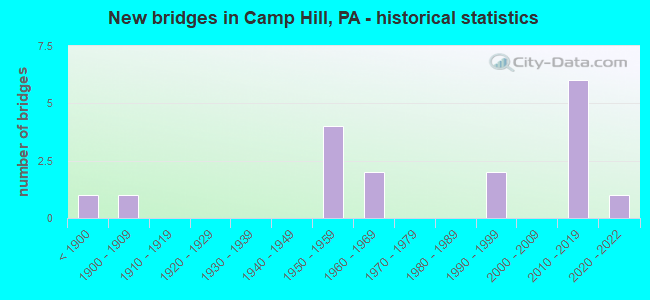
- New bridges - historical statistics
- 1Before 1900
- 11900-1909
- 41950-1959
- 21960-1969
- 21990-1999
- 62010-2019
- 12020-2022
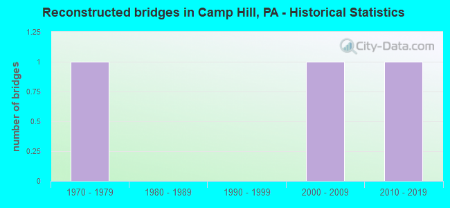
- Reconstructed bridges - Historical Statistics
- 11970-1979
- 01980-1989
- 01990-1999
- 12000-2009
- 12010-2019
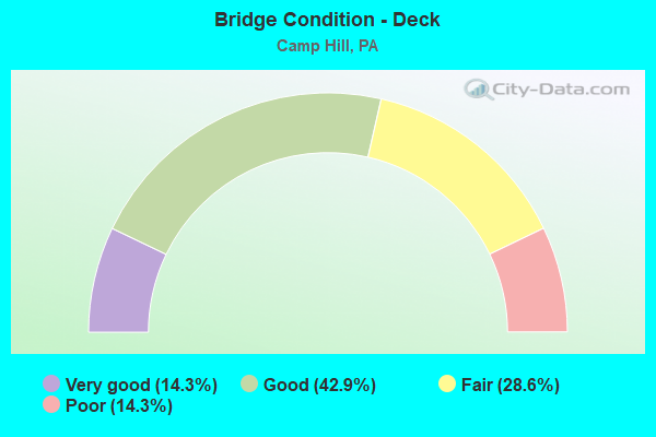
- Bridge Condition - Deck
- 14.3%Very good
- 42.9%Good
- 28.6%Fair
- 14.3%Poor
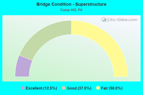
- Bridge Condition - Superstructure
- 12.5%Excellent
- 37.5%Good
- 50.0%Fair
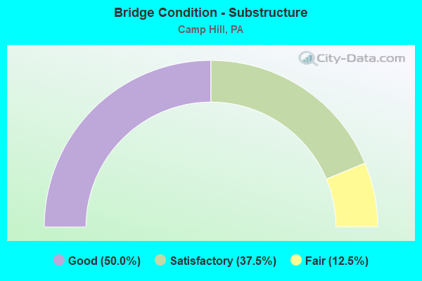
- Bridge Condition - Substructure
- 50.0%Good
- 37.5%Satisfactory
- 12.5%Fair

- Bridge Condition - Channel
- 50.0%Satisfactory
- 50.0%Fair
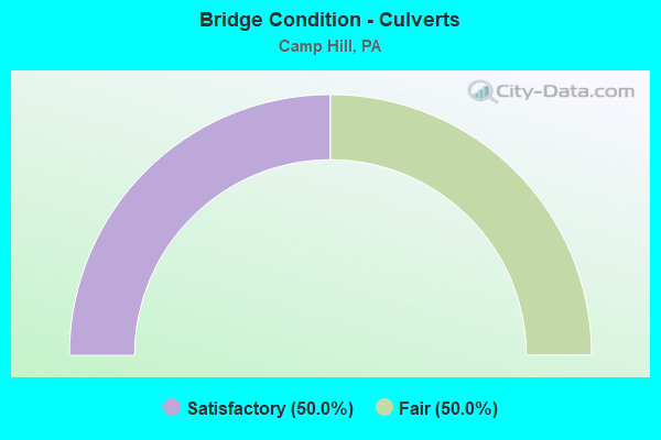
- Bridge Condition - Culverts
- 50.0%Satisfactory
- 50.0%Fair
Find on map >> Show street view
Structure Number: 4532, Location: HEWITT (Lat: 39.758853, Lng: -78.517608), Route carried "on" structure: City street , Year Built: 1993, Status: Open, Structure Length: 0.88m (2.89ft), Average Daily Traffic: 35 (year 2021), Average Future Daily Traffic: 49 (year 2041), Design Load: HS 25 or greater, Features Intersected: BLACK VALLEY BR TOWN CRK, Facility Carried by Structure: T306,TOWN CREEK RD
Minimum Vertical Clearance: 30+ m (98+ ft), Kilometerpoint: 0.000, Lanes on structure: 2, Owner: Town or Township Highway Agency, Approaching Roadway Width: 6.7m (22.0ft), Skew: 2 degrees, Material/Design: Concrete, Design/Construction: Culvert, Number Of Spans In Main Unit: 2, Length of Maximum Span: 4.0m (13.1ft), Curb or Sidewalk Widths: Left: 0.5m (1.6ft), Right: 0.5m (1.6ft), Curb-To-Curb Width: 6.7m (22.0ft), Out-to-Out Width: 8.4m (27.6ft)
Condition: Channel: Satisfactory, Culverts: Satisfactory, Operating Rating: 80.7 metric tons, Method Used To Determine Operating Rating: Load Factor (LF), Inventory Rating: 48.1 metric tons, Method Used To Determine Inventory Rating: Load Factor (LF), Structural Evaluation: Equal to present minimum criteria, Deck Geometry: Somewhat better than minimum adequacy, Waterway Adequacy: Better than present minimum criteria, Approach Roadway Alignment: Equal to present desirable criteria, Length Of Structure Improvement: 1.60m (5.25ft), Designated Inspection Frequency: Every 24 months, Inspection Date: January 2021, Wearing Surface/Protective System: Wearing Surface: Bituminous, Membrane: Built-up, Deck Protection: Epoxy Coated Reinforcing
Find on map >> Show street view
Structure Number: 7708, Location: QUAKERTOWN INTERCHANGE (Lat: 40.438114, Lng: -75.426244), Route carried "on" structure: Ramp Interstate 476, Year Built: 1955, Year Reconstructed: 1981, Status: Open, Structure Length: 4.88m (16.01ft), Average Daily Traffic: 10,774 (year 1994), Truck Traffic: 8%, Average Future Daily Traffic: 20,049 (year 2030), Design Load: HS 20, Features Intersected: PA TPK (I-476), Facility Carried by Structure: PA TPK. RAMP AB
Minimum Vertical Clearance: 30+ m (98+ ft), Kilometerpoint: 0.000, Lanes on structure: 2, Lanes under structure: 5, Base Highway Network: Yes, Toll: On toll road, Owner: State Toll Authority, Approaching Roadway Width: 9.4m (30.8ft), Skew: 30 degrees, Material/Design: Steel continuous, Design/Construction: Stringer/Multi-beam, Number Of Spans In Main Unit: 3, Length of Maximum Span: 22.3m (73.2ft), Curb or Sidewalk Widths: Left: 0.2m (0.7ft), Right: 0.2m (0.7ft), Curb-To-Curb Width: 9.4m (30.8ft), Out-to-Out Width: 11.2m (36.7ft)
Condition: Deck: Poor, Superstructure: Fair, Substructure: Satisfactory, Operating Rating: 67.1 metric tons, Method Used To Determine Operating Rating: Load Factor (LF), Inventory Rating: 39.9 metric tons, Method Used To Determine Inventory Rating: Load Factor (LF), Structural Evaluation: Somewhat better than minimum adequacy, Deck Geometry: Somewhat better than minimum adequacy, Underclear: High priority of corrective action, Approach Roadway Alignment: Better than present minimum criteria, Length Of Structure Improvement: 5.80m (19.03ft), Designated Inspection Frequency: Every 24 months, Critical Feature Inspection Frequency: Every 24 months, Inspection Date: March 2021, Critical Feature Inspection Date: March 2021, Bridge Improvement Cost: $42,000, Roadway Improvement Cost: $122,000, Total Project Cost: $561,000, Deck Structure Type: Concrete Precast Panels, Wearing Surface/Protective System: Wearing Surface: Latex Concrete
Find on map >> Show street view
Structure Number: 10631, Location: NR. READING FURNACE 11H1 (Lat: 40.147489, Lng: -75.768519), Route carried "on" structure: State highway , Year Built: 1904, Status: Open, Structure Length: 0.82m (2.69ft), Average Daily Traffic: 238 (year 2019), Truck Traffic: 11%, Average Future Daily Traffic: 329 (year 2032), Design Load: H 15, Features Intersected: SOUTH BR. FRENCH CREEK, Facility Carried by Structure: MANSION ROAD
Minimum Vertical Clearance: 30+ m (98+ ft), Kilometerpoint: 1.086, Lanes on structure: 1, Owner: State Highway Agency, Approaching Roadway Width: 4.9m (16.1ft), Material/Design: Masonry, Design/Construction: Arch - Deck, Number Of Spans In Main Unit: 1, Length of Maximum Span: 7.6m (24.9ft), Curb-To-Curb Width: 4.6m (15.1ft), Out-to-Out Width: 4.9m (16.1ft)
Condition: Superstructure: Fair, Substructure: Satisfactory, Channel: Satisfactory, Operating Rating: 58.1 metric tons, Method Used To Determine Operating Rating: Field evaluation and documented engineering judgment, Inventory Rating: 34.5 metric tons, Method Used To Determine Inventory Rating: Field evaluation and documented engineering judgment, Structural Evaluation: Somewhat better than minimum adequacy, Deck Geometry: High priority of replacement, Waterway Adequacy: Better than present minimum criteria, Approach Roadway Alignment: Equal to present desirable criteria, Length Of Structure Improvement: 1.40m (4.59ft), Designated Inspection Frequency: Every 24 months, Inspection Date: April 2021, Bridge Improvement Cost: $5,000, Roadway Improvement Cost: $15,000, Total Project Cost: $70,000
Find on map >> Show street view
Structure Number: 13584, Location: NEAR CAMP HILL (Lat: 40.250478, Lng: -76.919472), Route carried "on" structure: US 11, Year Built: 1952, Status: Open, Structure Length: 2.41m (7.91ft), Average Daily Traffic: 2,158 (year 2020), Truck Traffic: 3%, Average Future Daily Traffic: 6,068 (year 2032), Design Load: HS 20, Features Intersected: SR 1014
Minimum Vertical Clearance: 30+ m (98+ ft), Kilometerpoint: 56.539, Lanes on structure: 1, Lanes under structure: 3, Base Highway Network: Yes, Owner: State Highway Agency, Approaching Roadway Width: 12.2m (40.0ft), Skew: 4 degrees, Material/Design: Steel, Design/Construction: Stringer/Multi-beam, Number Of Spans In Main Unit: 1, Length of Maximum Span: 22.3m (73.2ft), Curb or Sidewalk Widths: Left: 0.5m (1.6ft), Right: 0.5m (1.6ft), Curb-To-Curb Width: 12.3m (40.4ft), Out-to-Out Width: 13.9m (45.6ft)
Condition: Deck: Fair, Superstructure: Fair, Substructure: Fair, Operating Rating: 63.5 metric tons, Method Used To Determine Operating Rating: Load Factor (LF), Inventory Rating: 38.1 metric tons, Method Used To Determine Inventory Rating: Load Factor (LF), Structural Evaluation: Somewhat better than minimum adequacy, Deck Geometry: Equal to present minimum criteria, Underclear: Equal to present minimum criteria, Approach Roadway Alignment: Equal to present desirable criteria, Length Of Structure Improvement: 3.20m (10.50ft), Designated Inspection Frequency: Every 24 months, Inspection Date: June 2020, Deck Structure Type: Concrete Cast-file-Place, Wearing Surface/Protective System: Wearing Surface: Bituminous, Membrane: Preformed Fabric
Find on map >> Show street view
Structure Number: 13859, Location: EAST PENNSBORO TWP (Lat: 40.255569, Lng: -76.927783), Route carried "on" structure: State highway , Year Built: 1969, Year Reconstructed: 2005, Status: Open, Structure Length: 20.24m (66.40ft), Average Daily Traffic: 11,008 (year 2022), Truck Traffic: 1%, Average Future Daily Traffic: 18,272 (year 2032), Design Load: HS 20, Features Intersected: CONODOGUINET CREEK&T-649, Facility Carried by Structure: SR 1015 CENTER ST.
Minimum Vertical Clearance: 30+ m (98+ ft), Kilometerpoint: 0.000, Lanes on structure: 2, Lanes under structure: 2, Owner: State Highway Agency, Approaching Roadway Width: 13.4m (44.0ft), Skew: 4 degrees, Material/Design: Prestressed concrete, Design/Construction: Stringer/Multi-beam, Number Of Spans In Main Unit: 8, Length of Maximum Span: 25.3m (83.0ft), Curb or Sidewalk Widths: Left: 0.2m (0.7ft), Right: 0.2m (0.7ft), Curb-To-Curb Width: 13.4m (44.0ft), Out-to-Out Width: 14.6m (47.9ft)
Condition: Deck: Fair, Superstructure: Fair, Substructure: Satisfactory, Channel: Fair, Operating Rating: 59.0 metric tons, Method Used To Determine Operating Rating: Load Factor (LF), Inventory Rating: 23.6 metric tons, Method Used To Determine Inventory Rating: Load Factor (LF), Structural Evaluation: Somewhat better than minimum adequacy, Deck Geometry: Equal to present minimum criteria, Underclear: Meets minimum limits, Waterway Adequacy: Equal to present desirable criteria, Approach Roadway Alignment: Equal to present desirable criteria, Length Of Structure Improvement: 20.90m (68.57ft), Designated Inspection Frequency: Every 24 months, Inspection Date: June 2020, Bridge Improvement Cost: $331,000, Roadway Improvement Cost: $975,000, Total Project Cost: $4,470,000, Deck Structure Type: Concrete Cast-file-Place, Wearing Surface/Protective System: Wearing Surface: Latex Concrete
Find on map >> Show street view
Structure Number: 14047, Location: 2.7 NW CAMP HILL/TR.CONOD (Lat: 40.256394, Lng: -76.967794), Route carried "on" structure: City street , Year Built: 1990, Status: Open, Structure Length: 0.88m (2.89ft), Average Daily Traffic: 150 (year 2021), Average Future Daily Traffic: 200 (year 2041), Design Load: HS 25 or greater, Features Intersected: TRIB CONODOGUINET CREEK, Facility Carried by Structure: SEARS RUN DRIVE
Minimum Vertical Clearance: 6.10m (20.01ft), Kilometerpoint: 0.000, Lanes on structure: 2, Owner: Town or Township Highway Agency, Approaching Roadway Width: 7.9m (25.9ft), Skew: 3 degrees, Material/Design: Steel, Design/Construction: Culvert, Number Of Spans In Main Unit: 1, Length of Maximum Span: 8.8m (28.9ft)
Condition: Channel: Fair, Culverts: Fair, Operating Rating: 49.0 metric tons, Method Used To Determine Operating Rating: Field evaluation and documented engineering judgment, Inventory Rating: 40.8 metric tons, Method Used To Determine Inventory Rating: Field evaluation and documented engineering judgment, Structural Evaluation: Somewhat better than minimum adequacy, Waterway Adequacy: Better than present minimum criteria, Approach Roadway Alignment: Equal to present desirable criteria, Length Of Structure Improvement: 1.30m (4.27ft), Designated Inspection Frequency: Every 24 months, Inspection Date: September 2021, Bridge Improvement Cost: $20,000, Roadway Improvement Cost: $58,000, Total Project Cost: $267,000
Find on map >> Show street view
Structure Number: 2213, Location: 2200 FT EAST OF SR 3028 (Lat: 39.978644, Lng: -76.225803), Route carried "on" structure: City street , Year Built: 1875, Year Reconstructed: 2018, Status: Posted for load, Structure Length: 2.74m (8.99ft), Average Daily Traffic: 1,200 (year 2012), Average Future Daily Traffic: 1,600 (year 2032), Design Load: HS 20, Features Intersected: PEQUEA CREEK, Facility Carried by Structure: PENN GRANT RD
Minimum Vertical Clearance: 3.20m (10.50ft), Kilometerpoint: 0.000, Lanes on structure: 1, Owner: County Highway Agency, Approaching Roadway Width: 6.1m (20.0ft), Material/Design: Wood or Timber, Design/Construction: Truss - Thru, Number Of Spans In Main Unit: 1, Length of Maximum Span: 27.4m (89.9ft), Curb-To-Curb Width: 3.5m (11.5ft), Out-to-Out Width: 4.7m (15.4ft)
Condition: Deck: Good, Superstructure: Good, Substructure: Good, Channel: Fair, Operating Rating: 4.5 metric tons, Method Used To Determine Operating Rating: Allowable Stress (AS), Inventory Rating: 2.7 metric tons, Method Used To Determine Inventory Rating: Allowable Stress (AS), Structural Evaluation: High priority of corrective action, Deck Geometry: High priority of replacement, Waterway Adequacy: Better than present minimum criteria, Approach Roadway Alignment: Equal to present minimum criteria, Bridge Posting: Required (Relationship of Operating Rating to Maximum Legal Load: > 39.9% below), Length Of Structure Improvement: 2.70m (8.86ft), Designated Inspection Frequency: Every 24 months, Other Special Inspection Frequency: Every 12 months, Inspection Date: December 2020, Other Special Inspection Date: December 2020, Bridge Improvement Cost: $6,000, Roadway Improvement Cost: $18,000, Total Project Cost: $82,000, Deck Structure Type: Wood or Timber
Find on map >> Show street view
Structure Number: 46024, Location: Near Camp Hill (Lat: 40.230003, Lng: -76.932139), Route carried "on" structure: US 15, Year Built: 2010, Status: Open, Structure Length: 5.64m (18.50ft), Average Daily Traffic: 72,895 (year 2022), Truck Traffic: 8%, Average Future Daily Traffic: 72,515 (year 2032), Design Load: HL 93, Features Intersected: NS RC
Minimum Vertical Clearance: 30+ m (98+ ft), Kilometerpoint: 10.940, Lanes on structure: 3, Base Highway Network: Yes, Owner: State Highway Agency, Approaching Roadway Width: 19.5m (64.0ft), Skew: 31 degrees, Material/Design: Prestressed concrete, Design/Construction: Box Beam or Girders - Single/Spread, Number Of Spans In Main Unit: 1, Number Of Approach Spans: 2, Length of Maximum Span: 22.3m (73.2ft), Curb or Sidewalk Widths: Left: 0.2m (0.7ft), Right: 0.2m (0.7ft), Curb-To-Curb Width: 16.2m (53.1ft), Out-to-Out Width: 38.3m (125.7ft)
Condition: Deck: Very good, Superstructure: Good, Substructure: Good, Operating Rating: 60.9 metric tons, Method Used To Determine Operating Rating: Assigned ratings based on Load and Resistance Factor Design (LRFD) reported by rating factor (RF) using HL93 loadings, Inventory Rating: 38.2 metric tons, Method Used To Determine Inventory Rating: Assigned ratings based on Load and Resistance Factor Design (LRFD) reported by rating factor (RF) using HL93 loadings, Structural Evaluation: Better than present minimum criteria, Deck Geometry: Equal to present minimum criteria, Underclear: High priority of corrective action, Approach Roadway Alignment: Equal to present desirable criteria, Designated Inspection Frequency: Every 24 months, Inspection Date: June 2020, Deck Structure Type: Concrete Cast-file-Place, Wearing Surface/Protective System: Wearing Surface: Monolithic Concrete, Deck Protection: Epoxy Coated Reinforcing
Find on map >> Show street view
Structure Number: 46028, Location: Camp Hill Boro (Lat: 40.231939, Lng: -76.932472), Route carried "on" structure: US 11, Year Built: 2010, Status: Open, Structure Length: 7.56m (24.80ft), Average Daily Traffic: 34,455 (year 2022), Truck Traffic: 4%, Average Future Daily Traffic: 53,272 (year 2032), Design Load: HL 93, Features Intersected: SR 0581 E & W
Minimum Vertical Clearance: 30.18m (99.02ft), Kilometerpoint: 54.674, Lanes on structure: 4, Lanes under structure: 8, Base Highway Network: Yes, Owner: State Highway Agency, Approaching Roadway Width: 38.4m (126.0ft), Skew: 30 degrees, Material/Design: Prestressed concrete continuous, Design/Construction: Box Beam or Girders - Single/Spread, Number Of Spans In Main Unit: 3, Length of Maximum Span: 25.9m (85.0ft), Curb or Sidewalk Widths: Left: 0.2m (0.7ft), Right: 0.2m (0.7ft), Curb-To-Curb Width: 18.9m (62.0ft), Out-to-Out Width: 40.7m (133.5ft)
Condition: Deck: Good, Superstructure: Good, Substructure: Good, Operating Rating: 68.0 metric tons, Method Used To Determine Operating Rating: Load and Resistance Factor (LRFR), Inventory Rating: 37.2 metric tons, Method Used To Determine Inventory Rating: Load and Resistance Factor (LRFR), Structural Evaluation: Better than present minimum criteria, Deck Geometry: Equal to present minimum criteria, Underclear: High priority of corrective action, Approach Roadway Alignment: Equal to present desirable criteria, Designated Inspection Frequency: Every 24 months, Inspection Date: June 2020, Deck Structure Type: Concrete Cast-file-Place, Wearing Surface/Protective System: Wearing Surface: Monolithic Concrete, Deck Protection: Epoxy Coated Reinforcing
Find on map >> Show street view
Structure Number: 67836, Location: 1.7 W CMP HILL HAMPDEN (Lat: 40.239833, Lng: -76.951789), Route carried "on" structure: City street , Year Built: 2020, Status: Open, Structure Length: 10.12m (33.20ft), Average Daily Traffic: 9,413 (year 2020), Truck Traffic: 5%, Average Future Daily Traffic: 11,973 (year 2040), Design Load: HL 93, Features Intersected: Conodoguinet Creek, Facility Carried by Structure: Orr's Bridge Road
Minimum Vertical Clearance: 30+ m (98+ ft), Kilometerpoint: 0.000, Lanes on structure: 2, Base Highway Network: Yes, Owner: County Highway Agency, Approaching Roadway Width: 10.4m (34.1ft), Skew: 9 degrees, Material/Design: Prestressed concrete continuous, Design/Construction: Box Beam or Girders - Single/Spread, Number Of Spans In Main Unit: 4, Length of Maximum Span: 25.9m (85.0ft), Curb or Sidewalk Widths: Left: 0.5m (1.6ft), Right: 2.8m (9.2ft), Curb-To-Curb Width: 10.4m (34.1ft), Out-to-Out Width: 13.6m (44.6ft)
Condition: Deck: Good, Superstructure: Excellent, Substructure: Good, Channel: Satisfactory, Operating Rating: 46.7 metric tons, Method Used To Determine Operating Rating: Assigned ratings based on Load and Resistance Factor Design (LRFD) reported by rating factor (RF) using HL93 loadings, Inventory Rating: 36.0 metric tons, Method Used To Determine Inventory Rating: Assigned ratings based on Load and Resistance Factor Design (LRFD) reported by rating factor (RF) using HL93 loadings, Structural Evaluation: Better than present minimum criteria, Deck Geometry: Meets minimum limits, Waterway Adequacy: Equal to present desirable criteria, Approach Roadway Alignment: Somewhat better than minimum adequacy, Designated Inspection Frequency: Every 24 months, Inspection Date: September 2021, Deck Structure Type: Concrete Cast-file-Place, Wearing Surface/Protective System: Wearing Surface: Monolithic Concrete, Deck Protection: Epoxy Coated Reinforcing
Find on map >> Show street view
Structure Number: 13584, Location: NEAR CAMP HILL (Lat: 40.250478, Lng: -76.919472), Route carried "under" structure: State highway , Year Built: 1952, Structure Length: 0. m, Average Daily Traffic: 894 (year 2022), Truck Traffic: 7%, Features Intersected: SR 1014, Facility Carried by Structure: US 11 SB; SR 0011
Minimum Vertical Clearance: 4.52m (14.83ft), Kilometerpoint: 0.000, Lanes on structure: 1, Lanes under structure: 1, Material/Design: Steel, Design/Construction: Stringer/Multi-beam, Length of Maximum Span: 22.3m (73.2ft)
Find on map >> Show street view
Structure Number: 13584, Location: NEAR CAMP HILL (Lat: 40.250478, Lng: -76.919472), Route carried "under" structure: State highway , Year Built: 1952, Structure Length: 0. m, Average Daily Traffic: 9,694 (year 2022), Truck Traffic: 2%, Features Intersected: SR 1014, Facility Carried by Structure: US 11 SB; SR 0011
Minimum Vertical Clearance: 30+ m (98+ ft), Kilometerpoint: 0.000, Lanes on structure: 1, Lanes under structure: 2, Material/Design: Steel, Design/Construction: Stringer/Multi-beam, Length of Maximum Span: 22.3m (73.2ft)
Find on map >> Show street view
Structure Number: 13859, Location: EAST PENNSBORO TWP (Lat: 40.255569, Lng: -76.927783), Route carried "under" structure: State highway , Year Built: 1969, Structure Length: 0. m, Average Daily Traffic: 10 (year 2004), Features Intersected: CONODOGUINET CREEK&T-649, Facility Carried by Structure: SR 1015 CENTER ST.
Minimum Vertical Clearance: 12.04m (39.50ft), Kilometerpoint: 0.000, Lanes on structure: 2, Lanes under structure: 2, Material/Design: Prestressed concrete, Design/Construction: Stringer/Multi-beam, Length of Maximum Span: 25.3m (83.0ft)
Find on map >> Show street view
Structure Number: 46028, Location: Camp Hill Boro (Lat: 40.231939, Lng: -76.932472), Route carried "under" structure: State highway 581, Year Built: 2010, Structure Length: 0. m, Average Daily Traffic: 44,126 (year 2021), Truck Traffic: 9%, Features Intersected: SR 0581 E & W, Facility Carried by Structure: US Rte 11
Minimum Vertical Clearance: 5.49m (18.01ft), Kilometerpoint: 8.208, Lanes on structure: 4, Lanes under structure: 2, Material/Design: Prestressed concrete continuous, Design/Construction: Box Beam or Girders - Single/Spread, Length of Maximum Span: 25.9m (85.0ft)
Find on map >> Show street view
Structure Number: 46028, Location: Camp Hill Boro (Lat: 40.231939, Lng: -76.932472), Route carried "under" structure: Ramp State highway , Year Built: 2010, Structure Length: 0. m, Average Daily Traffic: 299 (year 2022), Truck Traffic: 10%, Features Intersected: SR 0581 E & W, Facility Carried by Structure: US Rte 11
Minimum Vertical Clearance: 5.51m (18.08ft), Kilometerpoint: 0.000, Lanes on structure: 4, Lanes under structure: 2, Material/Design: Prestressed concrete continuous, Design/Construction: Box Beam or Girders - Single/Spread, Length of Maximum Span: 25.9m (85.0ft)
Find on map >> Show street view
Structure Number: 46028, Location: Camp Hill Boro (Lat: 40.231939, Lng: -76.932472), Route carried "under" structure: Ramp State highway , Year Built: 2010, Structure Length: 0. m, Average Daily Traffic: 16,966 (year 2022), Truck Traffic: 7%, Features Intersected: SR 0581 E & W, Facility Carried by Structure: US Rte 11
Minimum Vertical Clearance: 6.00m (19.69ft), Kilometerpoint: 0.000, Lanes on structure: 4, Lanes under structure: 2, Material/Design: Prestressed concrete continuous, Design/Construction: Box Beam or Girders - Single/Spread, Length of Maximum Span: 25.9m (85.0ft)
Find on map >> Show street view
Structure Number: 46028, Location: Camp Hill Boro (Lat: 40.231939, Lng: -76.932472), Route carried "under" structure: State highway 581, Year Built: 2010, Structure Length: 0. m, Average Daily Traffic: 40,953 (year 2021), Truck Traffic: 9%, Features Intersected: SR 0581 E & W, Facility Carried by Structure: US Rte 11
Minimum Vertical Clearance: 5.49m (18.01ft), Kilometerpoint: 8.232, Lanes on structure: 4, Lanes under structure: 2, Material/Design: Prestressed concrete continuous, Design/Construction: Box Beam or Girders - Single/Spread, Length of Maximum Span: 25.9m (85.0ft)