Bridge Statistics for Calverton, New York (NY)
Condition, Traffic, Stress, Structural Evaluation, Project Costs
- National Bridge Inventory (NBI) Statistics
- 13Number of bridges
- 190ft / 58.3mTotal length
- $83,253,000Total costs
- 126,785Total average daily traffic
- 3,998Total average daily truck traffic
- National Bridge Inventory (NBI) Registered Bridges for Calverton
- No street view available for this location
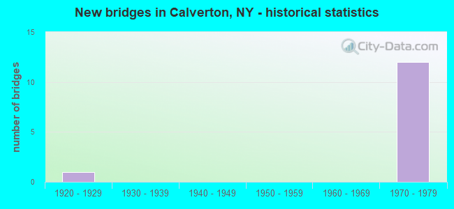
- New bridges - historical statistics
- 11920-1929
- 121970-1979
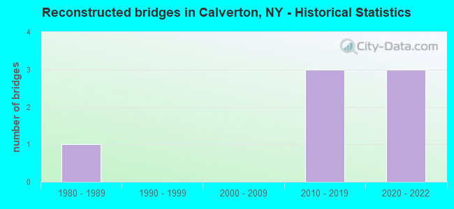
- Reconstructed bridges - Historical Statistics
- 11980-1989
- 01990-1999
- 02000-2009
- 32010-2019
- 32020-2022
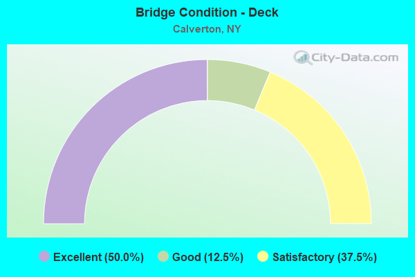
- Bridge Condition - Deck
- 50.0%Excellent
- 12.5%Good
- 37.5%Satisfactory
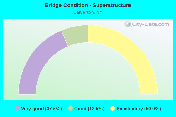
- Bridge Condition - Superstructure
- 37.5%Very good
- 12.5%Good
- 50.0%Satisfactory
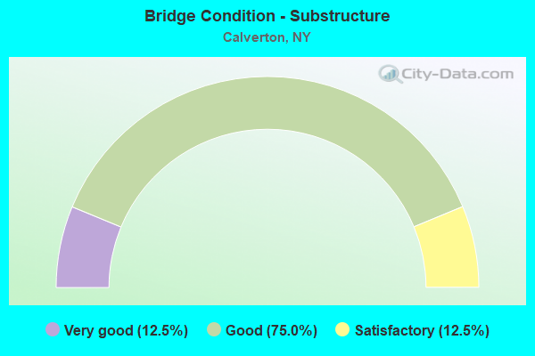
- Bridge Condition - Substructure
- 12.5%Very good
- 75.0%Good
- 12.5%Satisfactory
Find on map >> Show street view
Structure Number: 1056191, Location: .4 MI N I495 + SH 24 (Lat: 40.909164, Lng: -72.737069), Route carried "on" structure: Interstate 495, Year Built: 1972, Year Reconstructed: 2020, Status: Open, Structure Length: 4.48m (14.70ft), Average Daily Traffic: 10,314 (year 2018), Truck Traffic: 5%, Average Future Daily Traffic: 10,829 (year 2040), Design Load: HS 20, Features Intersected: RIVER RD
Minimum Vertical Clearance: 30+ m (98+ ft), Kilometerpoint: 63.314, Lanes on structure: 3, Lanes under structure: 2, Base Highway Network: Yes, Owner: State Highway Agency, Approaching Roadway Width: 16.2m (53.1ft), Skew: 4 degrees, Material/Design: Steel, Design/Construction: Stringer/Multi-beam, Number Of Spans In Main Unit: 1, Length of Maximum Span: 42.6m (139.8ft), Curb-To-Curb Width: 16.2m (53.1ft), Out-to-Out Width: 17.1m (56.1ft)
Condition: Deck: Excellent, Superstructure: Satisfactory, Substructure: Good, Operating Rating: 36.9 metric tons, Method Used To Determine Operating Rating: Load and Resistance Factor Rating (LRFR) rating reported by rating factor(RF) method using HL-93 loadings, Inventory Rating: 28.5 metric tons, Method Used To Determine Inventory Rating: Load and Resistance Factor Rating (LRFR) rating reported by rating factor(RF) method using HL-93 loadings, Structural Evaluation: Equal to present minimum criteria, Deck Geometry: Equal to present minimum criteria, Underclear: Better than present minimum criteria, Approach Roadway Alignment: Equal to present desirable criteria, Length Of Structure Improvement: 4.48m (14.70ft), Designated Inspection Frequency: Every 24 months, Inspection Date: September 2020, Bridge Improvement Cost: $4,527,000, Roadway Improvement Cost: $2,651,000, Total Project Cost: $7,179,000 ( Estimate for 2021), Deck Structure Type: Concrete Cast-file-Place, Wearing Surface/Protective System: Wearing Surface: Monolithic Concrete
Find on map >> Show street view
Structure Number: 1056192, Location: .4 MI N I495 + SH 24 (Lat: 40.909267, Lng: -72.736594), Route carried "on" structure: Interstate 495, Year Built: 1972, Year Reconstructed: 2020, Status: Open, Structure Length: 4.48m (14.70ft), Average Daily Traffic: 10,314 (year 2018), Truck Traffic: 5%, Average Future Daily Traffic: 10,829 (year 2040), Design Load: HS 20, Features Intersected: RIVER RD
Minimum Vertical Clearance: 30+ m (98+ ft), Kilometerpoint: 63.314, Lanes on structure: 3, Lanes under structure: 2, Base Highway Network: Yes, Owner: State Highway Agency, Approaching Roadway Width: 16.2m (53.1ft), Skew: 4 degrees, Material/Design: Steel, Design/Construction: Stringer/Multi-beam, Number Of Spans In Main Unit: 1, Length of Maximum Span: 42.6m (139.8ft), Curb-To-Curb Width: 16.2m (53.1ft), Out-to-Out Width: 17.1m (56.1ft)
Condition: Deck: Excellent, Superstructure: Very good, Substructure: Good, Operating Rating: 65.3 metric tons, Method Used To Determine Operating Rating: Load Factor (LF), Inventory Rating: 39.0 metric tons, Method Used To Determine Inventory Rating: Load Factor (LF), Structural Evaluation: Better than present minimum criteria, Deck Geometry: Equal to present minimum criteria, Underclear: Better than present minimum criteria, Approach Roadway Alignment: Equal to present desirable criteria, Length Of Structure Improvement: 4.48m (14.70ft), Designated Inspection Frequency: Every 24 months, Inspection Date: December 2020, Bridge Improvement Cost: $4,322,000, Roadway Improvement Cost: $2,531,000, Total Project Cost: $6,853,000 ( Estimate for 2021), Deck Structure Type: Concrete Cast-file-Place, Wearing Surface/Protective System: Wearing Surface: Integral Concrete, Deck Protection: Epoxy Coated Reinforcing
Find on map >> Show street view
Structure Number: 1056201, Location: .8 MILE N JCT I495 & SH24 (Lat: 40.913661, Lng: -72.733481), Route carried "on" structure: Interstate 495, Year Built: 1972, Year Reconstructed: 2015, Status: Open, Structure Length: 10.12m (33.20ft), Average Daily Traffic: 10,314 (year 2018), Truck Traffic: 5%, Average Future Daily Traffic: 10,829 (year 2040), Design Load: HS 20, Features Intersected: LIRR- MAIN LINE
Minimum Vertical Clearance: 30+ m (98+ ft), Kilometerpoint: 63.893, Lanes on structure: 3, Base Highway Network: Yes, Owner: State Highway Agency, Approaching Roadway Width: 16.2m (53.1ft), Skew: 5 degrees, Material/Design: Steel, Design/Construction: Stringer/Multi-beam, Number Of Spans In Main Unit: 3, Length of Maximum Span: 40.8m (133.9ft), Curb-To-Curb Width: 16.2m (53.1ft), Out-to-Out Width: 17.1m (56.1ft)
Condition: Deck: Good, Superstructure: Satisfactory, Substructure: Good, Operating Rating: 36.0 metric tons, Method Used To Determine Operating Rating: Load and Resistance Factor Rating (LRFR) rating reported by rating factor(RF) method using HL-93 loadings, Inventory Rating: 27.9 metric tons, Method Used To Determine Inventory Rating: Load and Resistance Factor Rating (LRFR) rating reported by rating factor(RF) method using HL-93 loadings, Structural Evaluation: Equal to present minimum criteria, Deck Geometry: Equal to present minimum criteria, Underclear: Somewhat better than minimum adequacy, Approach Roadway Alignment: Equal to present desirable criteria, Length Of Structure Improvement: 10.11m (33.17ft), Designated Inspection Frequency: Every 24 months, Inspection Date: August 2021, Bridge Improvement Cost: $7,547,000, Roadway Improvement Cost: $4,419,000, Total Project Cost: $11,966,000 ( Estimate for 2021), Deck Structure Type: Concrete Cast-file-Place, Wearing Surface/Protective System: Wearing Surface: Integral Concrete
Find on map >> Show street view
Structure Number: 1056202, Location: .8 MILE N JCT I495 & SH 2 (Lat: 40.913858, Lng: -72.732850), Route carried "on" structure: Interstate 495, Year Built: 1972, Year Reconstructed: 2015, Status: Open, Structure Length: 9.91m (32.51ft), Average Daily Traffic: 10,314 (year 2018), Truck Traffic: 5%, Average Future Daily Traffic: 10,829 (year 2040), Design Load: HS 20, Features Intersected: LIRR - MAIN LINE
Minimum Vertical Clearance: 30+ m (98+ ft), Kilometerpoint: 63.893, Lanes on structure: 2, Base Highway Network: Yes, Owner: State Highway Agency, Approaching Roadway Width: 16.2m (53.1ft), Skew: 5 degrees, Material/Design: Steel, Design/Construction: Stringer/Multi-beam, Number Of Spans In Main Unit: 3, Length of Maximum Span: 39.9m (130.9ft), Curb-To-Curb Width: 16.2m (53.1ft), Out-to-Out Width: 17.1m (56.1ft)
Condition: Deck: Satisfactory, Superstructure: Satisfactory, Substructure: Good, Operating Rating: 45.7 metric tons, Method Used To Determine Operating Rating: Load and Resistance Factor Rating (LRFR) rating reported by rating factor(RF) method using HL-93 loadings, Inventory Rating: 35.3 metric tons, Method Used To Determine Inventory Rating: Load and Resistance Factor Rating (LRFR) rating reported by rating factor(RF) method using HL-93 loadings, Structural Evaluation: Equal to present minimum criteria, Deck Geometry: Superior to present desirable criteria, Underclear: Somewhat better than minimum adequacy, Approach Roadway Alignment: Equal to present desirable criteria, Length Of Structure Improvement: 9.90m (32.48ft), Designated Inspection Frequency: Every 24 months, Inspection Date: August 2021, Bridge Improvement Cost: $7,287,000, Roadway Improvement Cost: $4,267,000, Total Project Cost: $11,553,000 ( Estimate for 2021), Deck Structure Type: Concrete Cast-file-Place, Wearing Surface/Protective System: Wearing Surface: Integral Concrete
Find on map >> Show street view
Structure Number: 1056219, Location: JCT I495 & SH 25 (Lat: 40.920344, Lng: -72.723708), Route carried "on" structure: State highway 25, Year Built: 1972, Year Reconstructed: 2017, Status: Open, Structure Length: 8.26m (27.10ft), Average Daily Traffic: 7,896 (year 2020), Truck Traffic: 8%, Average Future Daily Traffic: 9,592 (year 2040), Design Load: HS 20, Features Intersected: 495I 495 07031402 EB to,
Minimum Vertical Clearance: 30+ m (98+ ft), Kilometerpoint: 64.843, Lanes on structure: 5, Lanes under structure: 6, Base Highway Network: Yes, Owner: State Highway Agency, Approaching Roadway Width: 25.6m (84.0ft), Skew: 20 degrees, Material/Design: Steel, Design/Construction: Stringer/Multi-beam, Number Of Spans In Main Unit: 2, Length of Maximum Span: 46.0m (150.9ft), Curb or Sidewalk Widths: Left: 0.0m, Right: 2.4m (7.9ft), Curb-To-Curb Width: 25.6m (84.0ft), Out-to-Out Width: 30.0m (98.4ft)
Condition: Deck: Excellent, Superstructure: Very good, Substructure: Very good, Operating Rating: 55.3 metric tons, Method Used To Determine Operating Rating: Load Factor (LF), Inventory Rating: 32.7 metric tons, Method Used To Determine Inventory Rating: Load Factor (LF), Structural Evaluation: Equal to present desirable criteria, Deck Geometry: Superior to present desirable criteria, Underclear: High priority of corrective action, Approach Roadway Alignment: Superior to present desirable criteria, Length Of Structure Improvement: 8.26m (27.10ft), Designated Inspection Frequency: Every 24 months, Inspection Date: March 2021, Bridge Improvement Cost: $10,976,000, Roadway Improvement Cost: $6,427,000, Total Project Cost: $17,403,000 ( Estimate for 2021), Deck Structure Type: Concrete Cast-file-Place, Wearing Surface/Protective System: Wearing Surface: Integral Concrete
Find on map >> Show street view
Structure Number: 105622, Location: 0.3 MI NE RTE 495+RTE 25 (Lat: 40.922778, Lng: -72.719781), Route carried "on" structure: Interstate 495, Year Built: 1972, Status: Open, Structure Length: 6.00m (19.69ft), Average Daily Traffic: 8,954 (year 2020), Truck Traffic: 5%, Average Future Daily Traffic: 9,401 (year 2040), Design Load: HS 20, Features Intersected: COUNTY ROAD 58, COUNTY R
Minimum Vertical Clearance: 30+ m (98+ ft), Kilometerpoint: 0.644, Lanes on structure: 4, Lanes under structure: 5, Owner: State Highway Agency, Approaching Roadway Width: 17.7m (58.1ft), Skew: 4 degrees, Material/Design: Steel, Design/Construction: Stringer/Multi-beam, Number Of Spans In Main Unit: 1, Length of Maximum Span: 57.9m (190.0ft), Curb-To-Curb Width: 17.5m (57.4ft), Out-to-Out Width: 18.4m (60.4ft)
Condition: Deck: Satisfactory, Superstructure: Good, Substructure: Good, Operating Rating: 33.4 metric tons, Method Used To Determine Operating Rating: Load and Resistance Factor Rating (LRFR) rating reported by rating factor(RF) method using HL-93 loadings, Inventory Rating: 25.9 metric tons, Method Used To Determine Inventory Rating: Load and Resistance Factor Rating (LRFR) rating reported by rating factor(RF) method using HL-93 loadings, Structural Evaluation: Equal to present minimum criteria, Deck Geometry: Meets minimum limits, Underclear: Equal to present minimum criteria, Approach Roadway Alignment: Superior to present desirable criteria, Length Of Structure Improvement: 6.00m (19.69ft), Designated Inspection Frequency: Every 24 months, Inspection Date: August 2020, Bridge Improvement Cost: $6,300,000, Roadway Improvement Cost: $3,689,000, Total Project Cost: $9,990,000 ( Estimate for 2021), Deck Structure Type: Concrete Cast-file-Place, Wearing Surface/Protective System: Wearing Surface: Integral Concrete
Find on map >> Show street view
Structure Number: 105623, Location: .3 MI NW RTE 495+RTE 25 (Lat: 40.923228, Lng: -72.726672), Route carried "on" structure: State highway 25, Year Built: 1972, Year Reconstructed: 2020, Status: Open, Structure Length: 5.76m (18.90ft), Average Daily Traffic: 5,825 (year 2020), Truck Traffic: 8%, Average Future Daily Traffic: 6,720 (year 2040), Design Load: HS 20, Features Intersected: COUNTY RD 58 EB
Minimum Vertical Clearance: 30+ m (98+ ft), Kilometerpoint: 64.440, Lanes on structure: 2, Lanes under structure: 2, Base Highway Network: Yes, Owner: State Highway Agency, Approaching Roadway Width: 12.8m (42.0ft), Skew: 5 degrees, Material/Design: Steel, Design/Construction: Stringer/Multi-beam, Number Of Spans In Main Unit: 1, Length of Maximum Span: 54.8m (179.8ft), Curb-To-Curb Width: 12.8m (42.0ft), Out-to-Out Width: 13.4m (44.0ft)
Condition: Deck: Excellent, Superstructure: Very good, Substructure: Good, Operating Rating: 71.7 metric tons, Method Used To Determine Operating Rating: Load Factor (LF), Inventory Rating: 42.6 metric tons, Method Used To Determine Inventory Rating: Load Factor (LF), Structural Evaluation: Better than present minimum criteria, Deck Geometry: Equal to present desirable criteria, Underclear: Equal to present minimum criteria, Approach Roadway Alignment: Superior to present desirable criteria, Length Of Structure Improvement: 5.76m (18.90ft), Designated Inspection Frequency: Every 24 months, Inspection Date: August 2020, Bridge Improvement Cost: $4,722,000, Roadway Improvement Cost: $2,765,000, Total Project Cost: $7,488,000 ( Estimate for 2021), Deck Structure Type: Concrete Cast-file-Place, Wearing Surface/Protective System: Wearing Surface: Integral Concrete, Deck Protection: Epoxy Coated Reinforcing
Find on map >> Show street view
Structure Number: 106087, Location: .8 MI W JCT I495 & SH25 (Lat: 40.916286, Lng: -72.709561), Route carried "on" structure: State highway 25, Year Built: 1924, Year Reconstructed: 1986, Status: Open, Structure Length: 9.27m (30.41ft), Average Daily Traffic: 7,896 (year 2018), Truck Traffic: 5%, Average Future Daily Traffic: 9,592 (year 2040), Design Load: H 20, Features Intersected: LONG ISLAND- M.L.
Minimum Vertical Clearance: 30+ m (98+ ft), Kilometerpoint: 66.178, Lanes on structure: 2, Base Highway Network: Yes, Owner: State Highway Agency, Approaching Roadway Width: 14.3m (46.9ft), Material/Design: Steel, Design/Construction: Stringer/Multi-beam, Number Of Spans In Main Unit: 5, Length of Maximum Span: 18.2m (59.7ft), Curb-To-Curb Width: 14.2m (46.6ft), Out-to-Out Width: 15.2m (49.9ft)
Condition: Deck: Satisfactory, Superstructure: Satisfactory, Substructure: Satisfactory, Operating Rating: 35.0 metric tons, Method Used To Determine Operating Rating: Load and Resistance Factor Rating (LRFR) rating reported by rating factor(RF) method using HL-93 loadings, Inventory Rating: 26.9 metric tons, Method Used To Determine Inventory Rating: Load and Resistance Factor Rating (LRFR) rating reported by rating factor(RF) method using HL-93 loadings, Structural Evaluation: Equal to present minimum criteria, Deck Geometry: Superior to present desirable criteria, Underclear: High priority of corrective action, Approach Roadway Alignment: Equal to present desirable criteria, Length Of Structure Improvement: 9.26m (30.38ft), Designated Inspection Frequency: Every 24 months, Critical Feature Inspection Frequency: Every 24 months, Inspection Date: August 2021, Critical Feature Inspection Date: August 2021, Bridge Improvement Cost: $6,824,000, Roadway Improvement Cost: $3,996,000, Total Project Cost: $10,821,000 ( Estimate for 2021), Deck Structure Type: Concrete Cast-file-Place, Wearing Surface/Protective System: Wearing Surface: Integral Concrete, Deck Protection: Epoxy Coated Reinforcing
Find on map >> Show street view
Structure Number: 1056191, Location: .4 MI N I495 + SH 24 (Lat: 40.909164, Lng: -72.737069), Route carried "under" structure: Other road , Year Built: 1972, Structure Length: 0. m, Average Daily Traffic: 800 (year 2021), Features Intersected: RIVER RD, Facility Carried by Structure: RTE I495
Minimum Vertical Clearance: 4.75m (15.58ft), Kilometerpoint: 0.000, Lanes on structure: 3, Lanes under structure: 2, Material/Design: Steel, Design/Construction: Stringer/Multi-beam, Length of Maximum Span: 42.6m (139.8ft)
Find on map >> Show street view
Structure Number: 1056192, Location: .4 MI N I495 + SH 24 (Lat: 40.909267, Lng: -72.736594), Route carried "under" structure: Other road , Year Built: 1972, Structure Length: 0. m, Average Daily Traffic: 800 (year 2021), Features Intersected: RIVER RD, Facility Carried by Structure: RTE I495
Minimum Vertical Clearance: 5.11m (16.77ft), Kilometerpoint: 0.000, Lanes on structure: 3, Lanes under structure: 2, Material/Design: Steel, Design/Construction: Stringer/Multi-beam, Length of Maximum Span: 42.6m (139.8ft)
Find on map >> Show street view
Structure Number: 1056219, Location: JCT I495 & SH 25 (Lat: 40.920344, Lng: -72.723708), Route carried "under" structure: Interstate 495, Year Built: 1972, Structure Length: 0. m, Average Daily Traffic: 12,600 (year 1982), Features Intersected: 495I 495 07031402 EB to,, Facility Carried by Structure: RTE 25
Minimum Vertical Clearance: 5.56m (18.24ft), Kilometerpoint: 65.181, Lanes on structure: 5, Lanes under structure: 4, Material/Design: Steel, Design/Construction: Stringer/Multi-beam, Length of Maximum Span: 46.0m (150.9ft)
Find on map >> Show street view
Structure Number: 105622, Location: 0.3 MI NE RTE 495+RTE 25 (Lat: 40.922778, Lng: -72.719781), Route carried "under" structure: County highway , Year Built: 1972, Structure Length: 0. m, Average Daily Traffic: 26,981 (year 2003), Features Intersected: COUNTY ROAD 58, COUNTY R, Facility Carried by Structure: RTE I495
Minimum Vertical Clearance: 4.65m (15.26ft), Kilometerpoint: 0.000, Lanes on structure: 4, Lanes under structure: 2, Material/Design: Steel, Design/Construction: Stringer/Multi-beam, Length of Maximum Span: 57.9m (190.0ft)
Find on map >> Show street view
Structure Number: 105623, Location: .3 MI NW RTE 495+RTE 25 (Lat: 40.923228, Lng: -72.726672), Route carried "under" structure: County highway , Year Built: 1972, Structure Length: 0. m, Average Daily Traffic: 13,777 (year 2003), Features Intersected: COUNTY RD 58 EB, Facility Carried by Structure: RTE 25
Minimum Vertical Clearance: 4.57m (14.99ft), Kilometerpoint: 0.000, Lanes on structure: 2, Lanes under structure: 2, Material/Design: Steel, Design/Construction: Stringer/Multi-beam, Length of Maximum Span: 54.8m (179.8ft)