Bridge Statistics for Callaway, Florida (FL)
Condition, Traffic, Stress, Structural Evaluation, Project Costs
- National Bridge Inventory (NBI) Statistics
- 11Number of bridges
- 118ft / 35.6mTotal length
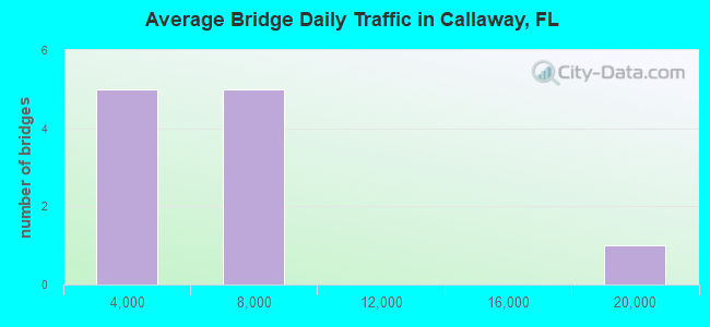
- 55,933Total average daily traffic
- 5,633Total average daily truck traffic
- 87,242Total future (year 2039) average daily traffic
- National Bridge Inventory (NBI) Registered Bridges for Callaway
- No street view available for this location
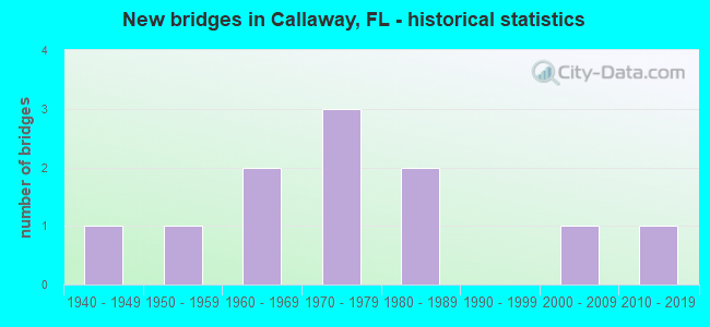
- New bridges - historical statistics
- 11940-1949
- 11950-1959
- 21960-1969
- 31970-1979
- 21980-1989
- 12000-2009
- 12010-2019
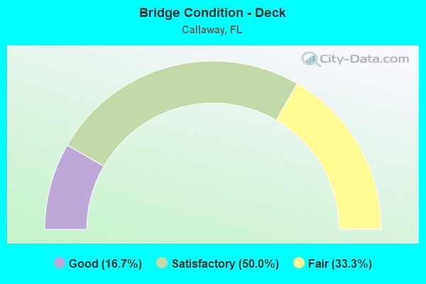
- Bridge Condition - Deck
- 16.7%Good
- 50.0%Satisfactory
- 33.3%Fair
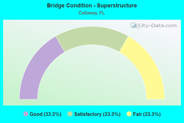
- Bridge Condition - Superstructure
- 33.3%Good
- 33.3%Satisfactory
- 33.3%Fair
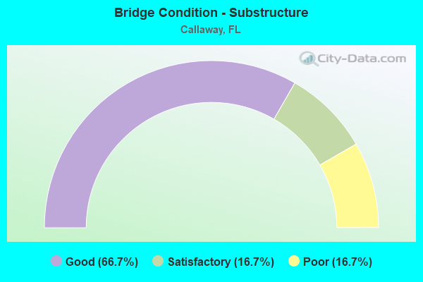
- Bridge Condition - Substructure
- 66.7%Good
- 16.7%Satisfactory
- 16.7%Poor
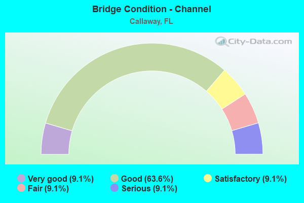
- Bridge Condition - Channel
- 9.1%Very good
- 63.6%Good
- 9.1%Satisfactory
- 9.1%Fair
- 9.1%Serious
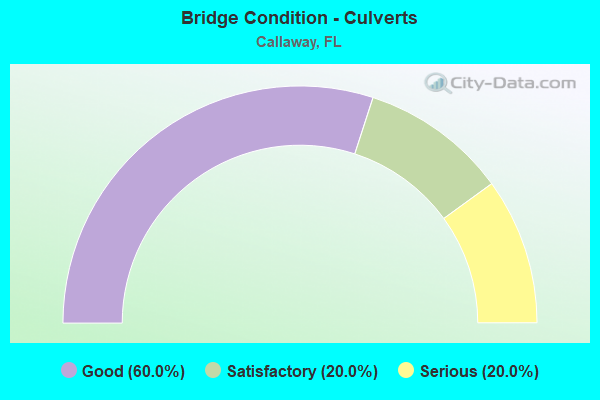
- Bridge Condition - Culverts
- 60.0%Good
- 20.0%Satisfactory
- 20.0%Serious
Find on map >> Show street view
Structure Number: 460031, Location: 1.0 Mile South of CR 22 (Lat: 30.138361, Lng: -85.574494), Route carried "on" structure: City street 729, Year Built: 1959, Status: Open, Structure Length: 0.95m (3.12ft), Average Daily Traffic: 3,600 (year 2020), Truck Traffic: 18%, Average Future Daily Traffic: 3,960 (year 2040), Features Intersected: Callaway Bayou, Facility Carried by Structure: S Berthe Avenue
Minimum Vertical Clearance: 30+ m (98+ ft), Kilometerpoint: 2.939, Lanes on structure: 2, Owner: City or Municipal Highway Agency, Approaching Roadway Width: 6.4m (21.0ft), Material/Design: Concrete, Design/Construction: Culvert, Number Of Spans In Main Unit: 3, Length of Maximum Span: 3.3m (10.8ft)
Condition: Channel: Serious, Culverts: Serious, Operating Rating: 45.1 metric tons, Method Used To Determine Operating Rating: Allowable Stress (AS), Inventory Rating: 26.9 metric tons, Method Used To Determine Inventory Rating: Allowable Stress (AS), Structural Evaluation: High priority of corrective action, Waterway Adequacy: Equal to present desirable criteria, Approach Roadway Alignment: Equal to present desirable criteria, Designated Inspection Frequency: Every 24 months, Underwater Inspection Frequency: Every 6 months, Other Special Inspection Frequency: Every 6 months, Inspection Date: December 2020, Underwater Inspection Date: December 2021, Other Special Inspection Date: December 2021
Find on map >> Show street view
Structure Number: 460033, Location: 0.72 Miles South of SR 22 (Lat: 30.142644, Lng: -85.565158), Route carried "on" structure: County highway , Year Built: 1973, Status: Open, Structure Length: 2.74m (8.99ft), Average Daily Traffic: 5,900 (year 2020), Truck Traffic: 9%, Average Future Daily Traffic: 6,490 (year 2040), Design Load: HS 20, Features Intersected: Callaway Bayou, Facility Carried by Structure: S Star Avenue
Minimum Vertical Clearance: 30+ m (98+ ft), Kilometerpoint: 0.697, Lanes on structure: 2, Owner: County Highway Agency, Approaching Roadway Width: 7.4m (24.3ft), Material/Design: Concrete continuous, Design/Construction: Slab, Number Of Spans In Main Unit: 3, Length of Maximum Span: 9.1m (29.9ft), Curb-To-Curb Width: 11.0m (36.1ft), Out-to-Out Width: 11.7m (38.4ft)
Condition: Deck: Fair, Superstructure: Fair, Substructure: Poor, Channel: Good, Operating Rating: 49.0 metric tons, Method Used To Determine Operating Rating: Load Factor (LF), Inventory Rating: 29.0 metric tons, Method Used To Determine Inventory Rating: Load Factor (LF), Structural Evaluation: Meets minimum limits, Deck Geometry: Meets minimum limits, Waterway Adequacy: Equal to present desirable criteria, Approach Roadway Alignment: Equal to present desirable criteria, Designated Inspection Frequency: Every 24 months, Underwater Inspection Frequency: Every 12 months, Other Special Inspection Frequency: Every 12 months, Inspection Date: December 2021, Underwater Inspection Date: December 2021, Other Special Inspection Date: December 2021, Deck Structure Type: Concrete Cast-file-Place
Find on map >> Show street view
Structure Number: 460045, Location: 2.0 Mi E. of US98 SR30A (Lat: 30.152858, Lng: -85.557561), Route carried "on" structure: State highway 22, Year Built: 1970, Status: Open, Structure Length: 4.02m (13.19ft), Average Daily Traffic: 7,100 (year 2020), Truck Traffic: 12%, Average Future Daily Traffic: 12,318 (year 2042), Design Load: HL 93, Features Intersected: Callaway Bayou
Minimum Vertical Clearance: 30+ m (98+ ft), Kilometerpoint: 5.718, Lanes on structure: 2, Owner: State Highway Agency, Approaching Roadway Width: 10.4m (34.1ft), Material/Design: Prestressed concrete, Design/Construction: Stringer/Multi-beam, Number Of Spans In Main Unit: 3, Length of Maximum Span: 13.4m (44.0ft), Curb-To-Curb Width: 13.2m (43.3ft), Out-to-Out Width: 14.1m (46.3ft)
Condition: Deck: Satisfactory, Superstructure: Good, Substructure: Satisfactory, Channel: Good, Operating Rating: 57.8 metric tons, Method Used To Determine Operating Rating: Load and Resistance Factor (LRFR), Inventory Rating: 43.7 metric tons, Method Used To Determine Inventory Rating: Load and Resistance Factor (LRFR), Structural Evaluation: Equal to present minimum criteria, Deck Geometry: Somewhat better than minimum adequacy, Waterway Adequacy: Superior to present desirable criteria, Approach Roadway Alignment: Equal to present desirable criteria, Designated Inspection Frequency: Every 24 months, Underwater Inspection Frequency: Every 24 months, Inspection Date: March 2021, Underwater Inspection Date: March 2021, Deck Structure Type: Concrete Cast-file-Place
Find on map >> Show street view
Structure Number: 460046, Location: 5.8 MI East of SR30A (Lat: 30.151694, Lng: -85.493472), Route carried "on" structure: State highway 22, Year Built: 1940, Status: Open, Structure Length: 0.98m (3.22ft), Average Daily Traffic: 4,000 (year 2020), Truck Traffic: 10%, Average Future Daily Traffic: 6,940 (year 2042), Design Load: HS 20, Features Intersected: Cushion Creek
Minimum Vertical Clearance: 30+ m (98+ ft), Kilometerpoint: 11.912, Lanes on structure: 2, Base Highway Network: Yes, Owner: State Highway Agency, Approaching Roadway Width: 10.4m (34.1ft), Material/Design: Concrete, Design/Construction: Culvert, Number Of Spans In Main Unit: 3, Length of Maximum Span: 3.0m (9.8ft)
Condition: Channel: Satisfactory, Culverts: Satisfactory, Operating Rating: 64.4 metric tons, Method Used To Determine Operating Rating: Load Factor (LF), Inventory Rating: 38.1 metric tons, Method Used To Determine Inventory Rating: Load Factor (LF), Structural Evaluation: Equal to present minimum criteria, Waterway Adequacy: Somewhat better than minimum adequacy, Approach Roadway Alignment: Equal to present desirable criteria, Designated Inspection Frequency: Every 24 months, Underwater Inspection Frequency: Every 24 months, Inspection Date: September 2020, Underwater Inspection Date: September 2020
Find on map >> Show street view
Structure Number: 460047, Location: 7.3MI East of SR30A (Lat: 30.150056, Lng: -85.472722), Route carried "on" structure: State highway 22, Year Built: 1970, Status: Open, Structure Length: 0.96m (3.15ft), Average Daily Traffic: 4,000 (year 2020), Truck Traffic: 10%, Average Future Daily Traffic: 6,940 (year 2042), Design Load: HS 20, Features Intersected: Cooks Bayou
Minimum Vertical Clearance: 30+ m (98+ ft), Kilometerpoint: 13.919, Lanes on structure: 2, Base Highway Network: Yes, Owner: State Highway Agency, Approaching Roadway Width: 10.4m (34.1ft), Material/Design: Concrete, Design/Construction: Culvert, Number Of Spans In Main Unit: 3, Length of Maximum Span: 3.0m (9.8ft)
Condition: Channel: Good, Culverts: Good, Operating Rating: 49.0 metric tons, Method Used To Determine Operating Rating: Load Factor (LF), Inventory Rating: 29.0 metric tons, Method Used To Determine Inventory Rating: Load Factor (LF), Structural Evaluation: Better than present minimum criteria, Waterway Adequacy: Equal to present desirable criteria, Approach Roadway Alignment: Equal to present desirable criteria, Designated Inspection Frequency: Every 24 months, Underwater Inspection Frequency: Every 24 months, Inspection Date: September 2020, Underwater Inspection Date: September 2020
Find on map >> Show street view
Structure Number: 460056, Location: 2.7 Mi.East of SR30A (Lat: 30.152722, Lng: -85.542700), Route carried "on" structure: State highway 22, Year Built: 1966, Status: Open, Structure Length: 0.64m (2.10ft), Average Daily Traffic: 7,100 (year 2020), Truck Traffic: 12%, Average Future Daily Traffic: 12,318 (year 2042), Design Load: HS 20, Features Intersected: Boggy Creek
Minimum Vertical Clearance: 30+ m (98+ ft), Kilometerpoint: 7.160, Lanes on structure: 2, Base Highway Network: Yes, Owner: State Highway Agency, Approaching Roadway Width: 10.4m (34.1ft), Material/Design: Concrete, Design/Construction: Culvert, Number Of Spans In Main Unit: 2, Length of Maximum Span: 3.0m (9.8ft)
Condition: Channel: Very good, Culverts: Good, Operating Rating: 49.0 metric tons, Method Used To Determine Operating Rating: Load Factor (LF), Inventory Rating: 29.0 metric tons, Method Used To Determine Inventory Rating: Load Factor (LF), Structural Evaluation: Better than present minimum criteria, Waterway Adequacy: Better than present minimum criteria, Approach Roadway Alignment: Equal to present desirable criteria, Designated Inspection Frequency: Every 24 months, Underwater Inspection Frequency: Every 24 months, Inspection Date: September 2020, Underwater Inspection Date: September 2020
Find on map >> Show street view
Structure Number: 460062, Location: 0.5 Mi. East of SR30A (Lat: 30.152931, Lng: -85.585300), Route carried "on" structure: State highway 22, Year Built: 1966, Status: Open, Structure Length: 0.69m (2.26ft), Average Daily Traffic: 18,300 (year 2020), Truck Traffic: 8%, Average Future Daily Traffic: 31,750 (year 2042), Design Load: HS 20, Features Intersected: Branch
Minimum Vertical Clearance: 30+ m (98+ ft), Kilometerpoint: 3.071, Lanes on structure: 2, Base Highway Network: Yes, Owner: State Highway Agency, Approaching Roadway Width: 10.4m (34.1ft), Material/Design: Concrete, Design/Construction: Culvert, Number Of Spans In Main Unit: 2, Length of Maximum Span: 3.0m (9.8ft)
Condition: Channel: Good, Culverts: Good, Operating Rating: 52.6 metric tons, Method Used To Determine Operating Rating: Load Factor (LF), Inventory Rating: 31.8 metric tons, Method Used To Determine Inventory Rating: Load Factor (LF), Structural Evaluation: Better than present minimum criteria, Waterway Adequacy: Equal to present desirable criteria, Approach Roadway Alignment: Equal to present desirable criteria, Designated Inspection Frequency: Every 24 months, Underwater Inspection Frequency: Every 24 months, Inspection Date: September 2020, Underwater Inspection Date: September 2020
Find on map >> Show street view
Structure Number: 464007, Location: 0.65 Miles West of CR2297 (Lat: 30.137872, Lng: -85.515836), Route carried "on" structure: County highway , Year Built: 1987, Status: Posted for load, Structure Length: 3.42m (11.22ft), Average Daily Traffic: 900 (year 2020), Truck Traffic: 12%, Average Future Daily Traffic: 990 (year 2040), Design Load: HL 93, Features Intersected: Laird Bayou, Facility Carried by Structure: Old Bicycle Road
Minimum Vertical Clearance: 30+ m (98+ ft), Kilometerpoint: 4.693, Lanes on structure: 2, Owner: County Highway Agency, Approaching Roadway Width: 9.4m (30.8ft), Material/Design: Steel, Design/Construction: Stringer/Multi-beam, Number Of Spans In Main Unit: 4, Length of Maximum Span: 8.6m (28.2ft), Curb or Sidewalk Widths: Left: 0.1m (0.3ft), Right: 0.1m (0.3ft), Curb-To-Curb Width: 7.3m (24.0ft), Out-to-Out Width: 8.1m (26.6ft)
Condition: Deck: Satisfactory, Superstructure: Fair, Substructure: Good, Channel: Fair, Operating Rating: 24.5 metric tons, Method Used To Determine Operating Rating: Load and Resistance Factor (LRFR), Inventory Rating: 19.1 metric tons, Method Used To Determine Inventory Rating: Load and Resistance Factor (LRFR), Structural Evaluation: Somewhat better than minimum adequacy, Deck Geometry: Meets minimum limits, Waterway Adequacy: Better than present minimum criteria, Approach Roadway Alignment: Equal to present desirable criteria, Bridge Posting: Required (Relationship of Operating Rating to Maximum Legal Load: 20.0 - 29.9% below), Designated Inspection Frequency: Every 24 months, Underwater Inspection Frequency: Every 24 months, Other Special Inspection Frequency: Every 12 months, Inspection Date: January 2022, Underwater Inspection Date: January 2022, Other Special Inspection Date: January 2022, Deck Structure Type: Concrete Cast-file-Place
Find on map >> Show street view
Structure Number: 464008, Location: 2.2 Miles West of CR2297 (Lat: 30.137783, Lng: -85.541325), Route carried "on" structure: County highway , Year Built: 1987, Status: Open, Structure Length: 0.86m (2.82ft), Average Daily Traffic: 3,600 (year 2019), Truck Traffic: 7%, Average Future Daily Traffic: 3,960 (year 2039), Design Load: HS 15, Features Intersected: Boggy Creek, Facility Carried by Structure: Old Bicycle Road
Minimum Vertical Clearance: 30+ m (98+ ft), Kilometerpoint: 2.245, Lanes on structure: 2, Owner: County Highway Agency, Approaching Roadway Width: 6.7m (22.0ft), Material/Design: Steel, Design/Construction: Stringer/Multi-beam, Number Of Spans In Main Unit: 1, Length of Maximum Span: 8.6m (28.2ft), Curb or Sidewalk Widths: Left: 0.1m (0.3ft), Right: 0.1m (0.3ft), Curb-To-Curb Width: 7.3m (24.0ft), Out-to-Out Width: 8.1m (26.6ft)
Condition: Deck: Fair, Superstructure: Satisfactory, Substructure: Good, Channel: Good, Operating Rating: 43.5 metric tons, Method Used To Determine Operating Rating: Allowable Stress (AS), Inventory Rating: 28.1 metric tons, Method Used To Determine Inventory Rating: Allowable Stress (AS), Structural Evaluation: Equal to present minimum criteria, Deck Geometry: High priority of replacement, Waterway Adequacy: Better than present minimum criteria, Approach Roadway Alignment: Equal to present desirable criteria, Designated Inspection Frequency: Every 24 months, Underwater Inspection Frequency: Every 24 months, Inspection Date: September 2020, Underwater Inspection Date: September 2020, Deck Structure Type: Concrete Cast-file-Place
Find on map >> Show street view
Structure Number: 464129, Location: 0.23 Mi N of Piercy Road (Lat: 30.061531, Lng: -85.485472), Route carried "on" structure: Other road , Year Built: 2004, Status: Open, Structure Length: 0.85m (2.79ft), Average Daily Traffic: 33 (year 2020), Average Future Daily Traffic: 36 (year 2040), Design Load: HS 20, Features Intersected: Richard Bayou, Facility Carried by Structure: Gore Road
Minimum Vertical Clearance: 30+ m (98+ ft), Kilometerpoint: 0.900, Lanes on structure: 2, Owner: County Highway Agency, Approaching Roadway Width: 6.7m (22.0ft), Material/Design: Concrete, Design/Construction: Slab, Number Of Spans In Main Unit: 1, Length of Maximum Span: 8.5m (27.9ft), Curb-To-Curb Width: 8.5m (27.9ft), Out-to-Out Width: 9.3m (30.5ft)
Condition: Deck: Satisfactory, Superstructure: Satisfactory, Substructure: Good, Channel: Good, Operating Rating: 80.7 metric tons, Method Used To Determine Operating Rating: Load Factor (LF), Inventory Rating: 48.1 metric tons, Method Used To Determine Inventory Rating: Load Factor (LF), Structural Evaluation: Equal to present minimum criteria, Deck Geometry: Better than present minimum criteria, Waterway Adequacy: Equal to present desirable criteria, Approach Roadway Alignment: Equal to present desirable criteria, Designated Inspection Frequency: Every 24 months, Inspection Date: January 2022, Deck Structure Type: Concrete Cast-file-Place
Find on map >> Show street view
Structure Number: 464141, Location: 1.652 MI S of SR 22 (Lat: 30.133447, Lng: -85.506375), Route carried "on" structure: County highway 2297, Year Built: 2019, Status: Open, Structure Length: 19.51m (64.01ft), Average Daily Traffic: 1,400 (year 2020), Truck Traffic: 9%, Average Future Daily Traffic: 1,540 (year 2040), Design Load: HL 93, Features Intersected: Cooks Bayou
Minimum Vertical Clearance: 30+ m (98+ ft), Kilometerpoint: 12.075, Lanes on structure: 2, Owner: County Highway Agency, Approaching Roadway Width: 13.5m (44.3ft), Material/Design: Prestressed concrete, Design/Construction: Stringer/Multi-beam, Number Of Spans In Main Unit: 9, Length of Maximum Span: 24.4m (80.1ft), Curb-To-Curb Width: 13.5m (44.3ft), Out-to-Out Width: 14.4m (47.2ft)
Condition: Deck: Good, Superstructure: Good, Substructure: Good, Channel: Good, Operating Rating: 55.5 metric tons, Method Used To Determine Operating Rating: Load and Resistance Factor (LRFR), Inventory Rating: 42.8 metric tons, Method Used To Determine Inventory Rating: Load and Resistance Factor (LRFR), Structural Evaluation: Better than present minimum criteria, Deck Geometry: Superior to present desirable criteria, Waterway Adequacy: Equal to present desirable criteria, Approach Roadway Alignment: Equal to present desirable criteria, Designated Inspection Frequency: Every 24 months, Underwater Inspection Frequency: Every 24 months, Inspection Date: December 2021, Underwater Inspection Date: December 2021, Deck Structure Type: Concrete Cast-file-Place