Bridge Statistics for Brooksville, Florida (FL)
Condition, Traffic, Stress, Structural Evaluation, Project Costs
- National Bridge Inventory (NBI) Statistics
- 28Number of bridges
- 213ft / 64.6mTotal length
- 328,230Total average daily traffic
- 32,843Total average daily truck traffic
- National Bridge Inventory (NBI) Registered Bridges for Brooksville
- No street view available for this location
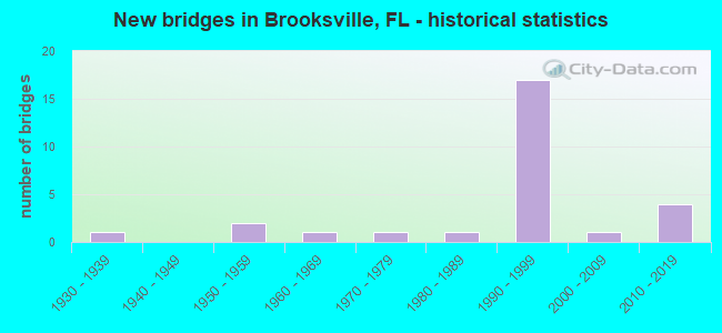
- New bridges - historical statistics
- 11930-1939
- 21950-1959
- 11960-1969
- 11970-1979
- 11980-1989
- 171990-1999
- 12000-2009
- 42010-2019


- Bridge Condition - Deck
- 54.5%Very good
- 45.5%Good

- Bridge Condition - Superstructure
- 54.5%Very good
- 45.5%Good

- Bridge Condition - Substructure
- 63.6%Very good
- 36.4%Good

- Bridge Condition - Channel
- 14.3%Very good
- 42.9%Good
- 42.9%Satisfactory

- Bridge Condition - Culverts
- 14.3%Very good
- 71.4%Good
- 14.3%Satisfactory
Find on map >> Show street view
Structure Number: 80001, Location: 1.3 Miles E of SR-50 (Lat: 28.554833, Lng: -82.391919), Route carried "on" structure: US 41, Year Built: 1936, Status: Open, Structure Length: 4.59m (15.06ft), Average Daily Traffic: 10,000 (year 2021), Truck Traffic: 8%, Average Future Daily Traffic: 17,350 (year 2041), Design Load: H 15, Features Intersected: CSX R/R
Minimum Vertical Clearance: 30+ m (98+ ft), Kilometerpoint: 15.200, Lanes on structure: 2, Base Highway Network: Yes, Owner: State Highway Agency, Approaching Roadway Width: 7.3m (24.0ft), Skew: 3 degrees, Material/Design: Steel, Design/Construction: Stringer/Multi-beam, Number Of Spans In Main Unit: 3, Length of Maximum Span: 15.4m (50.5ft), Curb or Sidewalk Widths: Left: 1.5m (4.9ft), Right: 1.5m (4.9ft), Curb-To-Curb Width: 7.3m (24.0ft), Out-to-Out Width: 11.2m (36.7ft)
Condition: Deck: Good, Superstructure: Good, Substructure: Good, Operating Rating: 51.7 metric tons, Method Used To Determine Operating Rating: Load Factor (LF), Inventory Rating: 30.8 metric tons, Method Used To Determine Inventory Rating: Load Factor (LF), Structural Evaluation: Better than present minimum criteria, Deck Geometry: High priority of replacement, Underclear: Somewhat better than minimum adequacy, Approach Roadway Alignment: Better than present minimum criteria, Designated Inspection Frequency: Every 24 months, Inspection Date: Febuary 2021, Deck Structure Type: Concrete Cast-file-Place, Wearing Surface/Protective System: Wearing Surface: Bituminous
Find on map >> Show street view
Structure Number: 80006, Location: 0.3MI WEST OF US-41 (Lat: 28.541817, Lng: -82.409656), Route carried "on" structure: State highway 50, Year Built: 1967, Year Reconstructed: 2001, Status: Open, Structure Length: 0.85m (2.79ft), Average Daily Traffic: 16,200 (year 2021), Truck Traffic: 14%, Average Future Daily Traffic: 28,107 (year 2041), Design Load: HS 20+Mod, Features Intersected: HORSE LAKE CREEK
Minimum Vertical Clearance: 30+ m (98+ ft), Kilometerpoint: 1.880, Lanes on structure: 4, Base Highway Network: Yes, Owner: State Highway Agency, Approaching Roadway Width: 17.6m (57.7ft), Skew: 12 degrees, Material/Design: Concrete, Design/Construction: Culvert, Number Of Spans In Main Unit: 3, Length of Maximum Span: 2.8m (9.2ft)
Condition: Channel: Good, Culverts: Good, Operating Rating: 38.6 metric tons, Method Used To Determine Operating Rating: Load and Resistance Factor (LRFR), Inventory Rating: 29.8 metric tons, Method Used To Determine Inventory Rating: Load and Resistance Factor (LRFR), Structural Evaluation: Better than present minimum criteria, Waterway Adequacy: Equal to present desirable criteria, Approach Roadway Alignment: Equal to present desirable criteria, Designated Inspection Frequency: Every 24 months, Inspection Date: Febuary 2021
Find on map >> Show street view
Structure Number: 80019, Location: 0.7MI W OF US-98 (Lat: 28.552778, Lng: -82.408250), Route carried "on" structure: State highway 50, Year Built: 1951, Status: Open, Structure Length: 0.73m (2.40ft), Average Daily Traffic: 11,100 (year 2021), Truck Traffic: 6%, Average Future Daily Traffic: 19,258 (year 2041), Design Load: H 15, Features Intersected: WOMBLES CREEK
Minimum Vertical Clearance: 30+ m (98+ ft), Kilometerpoint: 17.091, Lanes on structure: 2, Base Highway Network: Yes, Owner: State Highway Agency, Approaching Roadway Width: 9.9m (32.5ft), Skew: 3 degrees, Material/Design: Concrete, Design/Construction: Culvert, Number Of Spans In Main Unit: 2, Length of Maximum Span: 3.4m (11.2ft)
Condition: Channel: Satisfactory, Culverts: Good, Operating Rating: 59.0 metric tons, Method Used To Determine Operating Rating: Load Factor (LF), Inventory Rating: 35.4 metric tons, Method Used To Determine Inventory Rating: Load Factor (LF), Structural Evaluation: Better than present minimum criteria, Waterway Adequacy: Equal to present desirable criteria, Approach Roadway Alignment: Equal to present desirable criteria, Designated Inspection Frequency: Every 24 months, Inspection Date: Febuary 2021
Find on map >> Show street view
Structure Number: 80027, Location: AT CR-485&SR-50 JUNCTION (Lat: 28.552786, Lng: -82.420700), Route carried "on" structure: County highway 485, Year Built: 1950, Year Reconstructed: 1999, Status: Open, Structure Length: 0.64m (2.10ft), Average Daily Traffic: 9,200 (year 2021), Truck Traffic: 5%, Average Future Daily Traffic: 15,962 (year 2041), Design Load: HS 20+Mod, Features Intersected: DIESEL DITCH
Minimum Vertical Clearance: 30+ m (98+ ft), Kilometerpoint: 0.031, Lanes on structure: 5, Base Highway Network: Yes, Owner: State Highway Agency, Approaching Roadway Width: 20.0m (65.6ft), Skew: 20 degrees, Material/Design: Concrete, Design/Construction: Culvert, Number Of Spans In Main Unit: 2, Length of Maximum Span: 3.0m (9.8ft)
Condition: Channel: Satisfactory, Culverts: Good, Operating Rating: 29.5 metric tons, Method Used To Determine Operating Rating: Load and Resistance Factor (LRFR), Inventory Rating: 22.8 metric tons, Method Used To Determine Inventory Rating: Load and Resistance Factor (LRFR), Structural Evaluation: Somewhat better than minimum adequacy, Waterway Adequacy: Better than present minimum criteria, Approach Roadway Alignment: Equal to present desirable criteria, Designated Inspection Frequency: Every 24 months, Inspection Date: Febuary 2021
Find on map >> Show street view
Structure Number: 80037, Location: 0.5MI WEST OF SR-577 (Lat: 28.548889, Lng: -82.426389), Route carried "on" structure: State highway 50, Year Built: 2000, Status: Open, Structure Length: 1.15m (3.77ft), Average Daily Traffic: 21,000 (year 2021), Truck Traffic: 9%, Average Future Daily Traffic: 36,435 (year 2041), Design Load: HS 20+Mod, Features Intersected: HORSE LAKE OVERFLOW
Minimum Vertical Clearance: 30+ m (98+ ft), Kilometerpoint: 15.176, Lanes on structure: 5, Base Highway Network: Yes, Owner: State Highway Agency, Approaching Roadway Width: 25.9m (85.0ft), Skew: 10 degrees, Material/Design: Concrete, Design/Construction: Culvert, Number Of Spans In Main Unit: 4, Length of Maximum Span: 2.7m (8.9ft)
Condition: Channel: Satisfactory, Culverts: Good, Inventory Rating: 67.5 metric tons, Method Used To Determine Inventory Rating: Load Factor (LF), Structural Evaluation: Better than present minimum criteria, Waterway Adequacy: Superior to present desirable criteria, Approach Roadway Alignment: Equal to present desirable criteria, Designated Inspection Frequency: Every 24 months, Inspection Date: Febuary 2021
Find on map >> Show street view
Structure Number: 8004, Location: 0.8MI S OF SPRING HILL DR (Lat: 28.470844, Lng: -82.478283), Route carried "on" structure: County highway , Year Built: 1999, Status: Open, Structure Length: 5.95m (19.52ft), Average Daily Traffic: 4,500 (year 2020), Truck Traffic: 8%, Average Future Daily Traffic: 6,000 (year 2040), Design Load: HS 20+Mod, Features Intersected: SR-589 (SUNCOAST PKWY), Facility Carried by Structure: CORPORATE BLVD
Minimum Vertical Clearance: 30+ m (98+ ft), Kilometerpoint: 0.735, Lanes on structure: 2, Lanes under structure: 4, Owner: County Highway Agency, Approaching Roadway Width: 13.4m (44.0ft), Material/Design: Prestressed concrete, Design/Construction: Stringer/Multi-beam, Number Of Spans In Main Unit: 2, Length of Maximum Span: 29.7m (97.4ft), Curb-To-Curb Width: 13.4m (44.0ft), Out-to-Out Width: 14.4m (47.2ft)
Condition: Deck: Good, Superstructure: Very good, Substructure: Very good, Operating Rating: 77.7 metric tons, Method Used To Determine Operating Rating: Load Factor (LF), Inventory Rating: 46.4 metric tons, Method Used To Determine Inventory Rating: Load Factor (LF), Structural Evaluation: Equal to present desirable criteria, Deck Geometry: Better than present minimum criteria, Underclear: Equal to present minimum criteria, Approach Roadway Alignment: Equal to present desirable criteria, Designated Inspection Frequency: Every 24 months, Inspection Date: June 2020, Deck Structure Type: Concrete Cast-file-Place
Find on map >> Show street view
Structure Number: 80041, Location: 3.9 MI SOUTH OF SR 50 (Lat: 28.481486, Lng: -82.482147), Route carried "on" structure: State highway 589, Year Built: 1999, Status: Open, Structure Length: 4.05m (13.29ft), Average Daily Traffic: 8,100 (year 2020), Truck Traffic: 10%, Average Future Daily Traffic: 14,054 (year 2042), Design Load: HS 20+Mod, Features Intersected: SPRING HILL DR CR 574
Minimum Vertical Clearance: 30+ m (98+ ft), Kilometerpoint: 5.567, Lanes on structure: 2, Lanes under structure: 7, Base Highway Network: Yes, Toll: On toll road, Owner: State Toll Authority, Approaching Roadway Width: 11.1m (36.4ft), Material/Design: Prestressed concrete, Design/Construction: Stringer/Multi-beam, Number Of Spans In Main Unit: 1, Length of Maximum Span: 40.5m (132.9ft), Curb-To-Curb Width: 12.2m (40.0ft), Out-to-Out Width: 12.8m (42.0ft)
Condition: Deck: Very good, Superstructure: Very good, Substructure: Very good, Operating Rating: 50.8 metric tons, Method Used To Determine Operating Rating: Load and Resistance Factor (LRFR), Inventory Rating: 41.6 metric tons, Method Used To Determine Inventory Rating: Load and Resistance Factor (LRFR), Structural Evaluation: Equal to present desirable criteria, Deck Geometry: Better than present minimum criteria, Underclear: Equal to present minimum criteria, Approach Roadway Alignment: Equal to present desirable criteria, Designated Inspection Frequency: Every 24 months, Inspection Date: May 2020, Deck Structure Type: Concrete Cast-file-Place
Find on map >> Show street view
Structure Number: 80042, Location: 3.9 MI SOUTH OF SR 50 (Lat: 28.481422, Lng: -82.482433), Route carried "on" structure: State highway 589, Year Built: 1999, Status: Open, Structure Length: 4.05m (13.29ft), Average Daily Traffic: 5,900 (year 2020), Truck Traffic: 10%, Average Future Daily Traffic: 10,236 (year 2042), Design Load: HS 20+Mod, Features Intersected: SPRING HILL DR CR 574
Minimum Vertical Clearance: 30+ m (98+ ft), Kilometerpoint: 5.570, Lanes on structure: 2, Lanes under structure: 7, Base Highway Network: Yes, Toll: On toll road, Owner: State Toll Authority, Approaching Roadway Width: 11.1m (36.4ft), Material/Design: Prestressed concrete, Design/Construction: Stringer/Multi-beam, Number Of Spans In Main Unit: 1, Length of Maximum Span: 40.5m (132.9ft), Curb-To-Curb Width: 12.2m (40.0ft), Out-to-Out Width: 12.8m (42.0ft)
Condition: Deck: Very good, Superstructure: Very good, Substructure: Very good, Operating Rating: 50.8 metric tons, Method Used To Determine Operating Rating: Load and Resistance Factor (LRFR), Inventory Rating: 41.6 metric tons, Method Used To Determine Inventory Rating: Load and Resistance Factor (LRFR), Structural Evaluation: Equal to present desirable criteria, Deck Geometry: Better than present minimum criteria, Underclear: Equal to present minimum criteria, Approach Roadway Alignment: Equal to present desirable criteria, Designated Inspection Frequency: Every 24 months, Inspection Date: May 2020, Deck Structure Type: Concrete Cast-file-Place
Find on map >> Show street view
Structure Number: 80043, Location: 3.1 MI SOUTH OF SR-50 (Lat: 28.492006, Lng: -82.481722), Route carried "on" structure: County highway 572, Year Built: 1999, Status: Open, Structure Length: 7.48m (24.54ft), Average Daily Traffic: 4,500 (year 2020), Truck Traffic: 8%, Average Future Daily Traffic: 6,000 (year 2040), Design Load: HS 20+Mod, Features Intersected: SR-589 (SUNCOAST PKWY), Facility Carried by Structure: POWELL RD
Minimum Vertical Clearance: 30+ m (98+ ft), Kilometerpoint: 4.632, Lanes on structure: 2, Lanes under structure: 4, Owner: County Highway Agency, Approaching Roadway Width: 15.8m (51.8ft), Skew: 3 degrees, Material/Design: Prestressed concrete, Design/Construction: Stringer/Multi-beam, Number Of Spans In Main Unit: 2, Length of Maximum Span: 37.4m (122.7ft), Curb or Sidewalk Widths: Left: 0.0m, Right: 2.5m (8.2ft), Curb-To-Curb Width: 15.8m (51.8ft), Out-to-Out Width: 19.7m (64.6ft)
Condition: Deck: Good, Superstructure: Good, Substructure: Good, Operating Rating: 70.5 metric tons, Method Used To Determine Operating Rating: Load Factor (LF), Inventory Rating: 42.2 metric tons, Method Used To Determine Inventory Rating: Load Factor (LF), Structural Evaluation: Better than present minimum criteria, Deck Geometry: Superior to present desirable criteria, Underclear: Equal to present minimum criteria, Approach Roadway Alignment: Equal to present desirable criteria, Designated Inspection Frequency: Every 24 months, Inspection Date: June 2020, Deck Structure Type: Concrete Cast-file-Place
Find on map >> Show street view
Structure Number: 80044, Location: 0.7 MI SOUTH OF SR 50 (Lat: 28.524431, Lng: -82.478789), Route carried "on" structure: State highway 589, Year Built: 1999, Status: Open, Structure Length: 2.20m (7.22ft), Average Daily Traffic: 5,900 (year 2020), Truck Traffic: 10%, Average Future Daily Traffic: 10,236 (year 2042), Design Load: HS 20+Mod, Features Intersected: HIGHFIELD RD
Minimum Vertical Clearance: 30+ m (98+ ft), Kilometerpoint: 10.570, Lanes on structure: 2, Lanes under structure: 2, Base Highway Network: Yes, Toll: On toll road, Owner: State Toll Authority, Approaching Roadway Width: 11.1m (36.4ft), Skew: 1 degrees, Material/Design: Prestressed concrete, Design/Construction: Stringer/Multi-beam, Number Of Spans In Main Unit: 1, Length of Maximum Span: 22.0m (72.2ft), Curb-To-Curb Width: 12.1m (39.7ft), Out-to-Out Width: 12.7m (41.7ft)
Condition: Deck: Very good, Superstructure: Very good, Substructure: Very good, Operating Rating: 44.3 metric tons, Method Used To Determine Operating Rating: Load and Resistance Factor (LRFR), Inventory Rating: 36.1 metric tons, Method Used To Determine Inventory Rating: Load and Resistance Factor (LRFR), Structural Evaluation: Equal to present desirable criteria, Deck Geometry: Equal to present minimum criteria, Underclear: Superior to present desirable criteria, Approach Roadway Alignment: Equal to present desirable criteria, Designated Inspection Frequency: Every 24 months, Inspection Date: May 2020, Deck Structure Type: Concrete Cast-file-Place
Find on map >> Show street view
Structure Number: 80045, Location: 0.7 MI SOUTH OF SR 50 (Lat: 28.524447, Lng: -82.479086), Route carried "on" structure: State highway 589, Year Built: 1999, Status: Open, Structure Length: 2.20m (7.22ft), Average Daily Traffic: 5,900 (year 2020), Truck Traffic: 10%, Average Future Daily Traffic: 10,236 (year 2042), Design Load: HS 20+Mod, Features Intersected: HIGHFIELD RD
Minimum Vertical Clearance: 30+ m (98+ ft), Kilometerpoint: 10.575, Lanes on structure: 2, Lanes under structure: 2, Base Highway Network: Yes, Toll: On toll road, Owner: State Toll Authority, Approaching Roadway Width: 11.1m (36.4ft), Skew: 1 degrees, Material/Design: Prestressed concrete, Design/Construction: Stringer/Multi-beam, Number Of Spans In Main Unit: 1, Length of Maximum Span: 22.0m (72.2ft), Curb-To-Curb Width: 12.1m (39.7ft), Out-to-Out Width: 12.7m (41.7ft)
Condition: Deck: Good, Superstructure: Good, Substructure: Very good, Operating Rating: 44.3 metric tons, Method Used To Determine Operating Rating: Load and Resistance Factor (LRFR), Inventory Rating: 36.1 metric tons, Method Used To Determine Inventory Rating: Load and Resistance Factor (LRFR), Structural Evaluation: Better than present minimum criteria, Deck Geometry: Equal to present minimum criteria, Underclear: Superior to present desirable criteria, Approach Roadway Alignment: Equal to present desirable criteria, Designated Inspection Frequency: Every 24 months, Inspection Date: May 2020, Deck Structure Type: Concrete Cast-file-Place
Find on map >> Show street view
Structure Number: 80046, Location: 3.9MI N OF SPRING HILL RD (Lat: 28.533928, Lng: -82.479264), Route carried "on" structure: State highway 589, Year Built: 1999, Status: Open, Structure Length: 5.19m (17.03ft), Average Daily Traffic: 5,900 (year 2020), Truck Traffic: 10%, Average Future Daily Traffic: 10,236 (year 2042), Design Load: HS 20+Mod, Features Intersected: SR 50
Minimum Vertical Clearance: 30+ m (98+ ft), Kilometerpoint: 11.607, Lanes on structure: 2, Lanes under structure: 7, Base Highway Network: Yes, Toll: On toll road, Owner: State Toll Authority, Approaching Roadway Width: 11.1m (36.4ft), Material/Design: Steel, Design/Construction: Stringer/Multi-beam, Number Of Spans In Main Unit: 1, Length of Maximum Span: 51.9m (170.3ft), Curb-To-Curb Width: 12.1m (39.7ft), Out-to-Out Width: 12.8m (42.0ft)
Condition: Deck: Very good, Superstructure: Good, Substructure: Good, Operating Rating: 73.1 metric tons, Method Used To Determine Operating Rating: Load Factor (LF), Inventory Rating: 44.0 metric tons, Method Used To Determine Inventory Rating: Load Factor (LF), Structural Evaluation: Better than present minimum criteria, Deck Geometry: Equal to present minimum criteria, Underclear: Superior to present desirable criteria, Approach Roadway Alignment: Equal to present desirable criteria, Designated Inspection Frequency: Every 24 months, Inspection Date: May 2020, Deck Structure Type: Concrete Cast-file-Place
Find on map >> Show street view
Structure Number: 80047, Location: 3.9MI N OF SPRING HILL RD (Lat: 28.533928, Lng: -82.479547), Route carried "on" structure: State highway 589, Year Built: 1999, Status: Open, Structure Length: 5.18m (16.99ft), Average Daily Traffic: 5,900 (year 2020), Truck Traffic: 10%, Average Future Daily Traffic: 10,236 (year 2042), Design Load: HS 20+Mod, Features Intersected: SR 50
Minimum Vertical Clearance: 30+ m (98+ ft), Kilometerpoint: 11.607, Lanes on structure: 2, Lanes under structure: 7, Base Highway Network: Yes, Toll: On toll road, Owner: State Toll Authority, Approaching Roadway Width: 11.2m (36.7ft), Material/Design: Steel, Design/Construction: Stringer/Multi-beam, Number Of Spans In Main Unit: 1, Length of Maximum Span: 51.8m (169.9ft), Curb-To-Curb Width: 12.1m (39.7ft), Out-to-Out Width: 12.8m (42.0ft)
Condition: Deck: Good, Superstructure: Good, Substructure: Good, Operating Rating: 73.1 metric tons, Method Used To Determine Operating Rating: Load Factor (LF), Inventory Rating: 44.0 metric tons, Method Used To Determine Inventory Rating: Load Factor (LF), Structural Evaluation: Better than present minimum criteria, Deck Geometry: Equal to present minimum criteria, Underclear: Superior to present desirable criteria, Approach Roadway Alignment: Equal to present desirable criteria, Designated Inspection Frequency: Every 24 months, Inspection Date: May 2020, Deck Structure Type: Concrete Cast-file-Place
Find on map >> Show street view
Structure Number: 80065, Location: 1.7 MILES W OF SR-577 (Lat: 28.541156, Lng: -82.444242), Route carried "on" structure: State highway 50, Year Built: 1999, Status: Open, Structure Length: 0.79m (2.59ft), Average Daily Traffic: 21,000 (year 2021), Truck Traffic: 9%, Average Future Daily Traffic: 36,435 (year 2041), Design Load: HS 20+Mod, Features Intersected: TYLERS DRAIN
Minimum Vertical Clearance: 30+ m (98+ ft), Kilometerpoint: 13.079, Lanes on structure: 6, Base Highway Network: Yes, Owner: State Highway Agency, Approaching Roadway Width: 17.1m (56.1ft), Skew: 14 degrees, Material/Design: Concrete, Design/Construction: Culvert, Number Of Spans In Main Unit: 2, Length of Maximum Span: 3.9m (12.8ft)
Condition: Channel: Good, Culverts: Good, Structural Evaluation: Better than present minimum criteria, Waterway Adequacy: Equal to present desirable criteria, Approach Roadway Alignment: Equal to present desirable criteria, Designated Inspection Frequency: Every 24 months, Inspection Date: Febuary 2021
Find on map >> Show street view
Structure Number: 80086, Location: 3.8 MI S/O CR-39/CROOM R (Lat: 28.523147, Lng: -82.237164), Route carried "on" structure: Interstate 75, Year Built: 2019, Status: Open, Structure Length: 9.10m (29.86ft), Average Daily Traffic: 24,500 (year 2021), Truck Traffic: 14%, Average Future Daily Traffic: 42,508 (year 2041), Design Load: HL 93, Features Intersected: US-98/SR-50/SR-700
Minimum Vertical Clearance: 30+ m (98+ ft), Kilometerpoint: 11.309, Lanes on structure: 3, Lanes under structure: 10, Base Highway Network: Yes, Owner: State Highway Agency, Approaching Roadway Width: 17.1m (56.1ft), Material/Design: Steel, Design/Construction: Stringer/Multi-beam, Number Of Spans In Main Unit: 1, Length of Maximum Span: 91.0m (298.6ft), Curb-To-Curb Width: 17.1m (56.1ft), Out-to-Out Width: 18.0m (59.1ft)
Condition: Deck: Very good, Superstructure: Very good, Substructure: Very good, Operating Rating: 73.8 metric tons, Method Used To Determine Operating Rating: Load and Resistance Factor (LRFR), Inventory Rating: 56.8 metric tons, Method Used To Determine Inventory Rating: Load and Resistance Factor (LRFR), Structural Evaluation: Equal to present desirable criteria, Deck Geometry: Equal to present minimum criteria, Underclear: Superior to present desirable criteria, Approach Roadway Alignment: Equal to present desirable criteria, Designated Inspection Frequency: Every 24 months, Inspection Date: Febuary 2021, Deck Structure Type: Concrete Cast-file-Place
Find on map >> Show street view
Structure Number: 80087, Location: 8.4 MI N/O CR-41/BLANTON (Lat: 28.523139, Lng: -82.236944), Route carried "on" structure: Interstate 75, Year Built: 2018, Status: Open, Structure Length: 9.10m (29.86ft), Average Daily Traffic: 24,250 (year 2022), Truck Traffic: 16%, Average Future Daily Traffic: 42,074 (year 2042), Design Load: HL 93, Features Intersected: US-98/SR-50/SR-700
Minimum Vertical Clearance: 30+ m (98+ ft), Kilometerpoint: 11.309, Lanes on structure: 3, Lanes under structure: 10, Base Highway Network: Yes, Owner: State Highway Agency, Approaching Roadway Width: 17.1m (56.1ft), Material/Design: Steel, Design/Construction: Stringer/Multi-beam, Number Of Spans In Main Unit: 1, Length of Maximum Span: 91.0m (298.6ft), Curb-To-Curb Width: 17.1m (56.1ft), Out-to-Out Width: 18.0m (59.1ft)
Condition: Deck: Very good, Superstructure: Very good, Substructure: Very good, Operating Rating: 73.8 metric tons, Method Used To Determine Operating Rating: Load and Resistance Factor (LRFR), Inventory Rating: 56.8 metric tons, Method Used To Determine Inventory Rating: Load and Resistance Factor (LRFR), Structural Evaluation: Equal to present desirable criteria, Deck Geometry: Equal to present minimum criteria, Underclear: Superior to present desirable criteria, Approach Roadway Alignment: Equal to present desirable criteria, Designated Inspection Frequency: Every 24 months, Inspection Date: Febuary 2022, Deck Structure Type: Concrete Cast-file-Place
Find on map >> Show street view
Structure Number: 85001, Location: 0.25MI N OF SR-50 (Lat: 28.545833, Lng: -82.410500), Route carried "on" structure: City street , Year Built: 1975, Status: Open, Structure Length: 0.64m (2.10ft), Average Daily Traffic: 220 (year 2020), Truck Traffic: 1%, Average Future Daily Traffic: 275 (year 2040), Features Intersected: HORSE LAKE CREEK, Facility Carried by Structure: CANDLELIGHT BLVD.
Minimum Vertical Clearance: 30+ m (98+ ft), Kilometerpoint: 0.406, Lanes on structure: 2, Owner: City or Municipal Highway Agency, Approaching Roadway Width: 6.2m (20.3ft), Material/Design: Concrete, Design/Construction: Culvert, Number Of Spans In Main Unit: 2, Length of Maximum Span: 3.0m (9.8ft)
Condition: Channel: Good, Culverts: Satisfactory, Inventory Rating: 54.2 metric tons, Method Used To Determine Inventory Rating: Load Factor (LF), Structural Evaluation: Equal to present minimum criteria, Waterway Adequacy: Better than present minimum criteria, Approach Roadway Alignment: Better than present minimum criteria, Designated Inspection Frequency: Every 24 months, Underwater Inspection Frequency: Every 24 months, Inspection Date: March 2020, Underwater Inspection Date: Febuary 2020
Find on map >> Show street view
Structure Number: 85003, Location: 200Ft. N of FORT DADE AVE (Lat: 28.556792, Lng: -82.400286), Route carried "on" structure: City street , Year Built: 1980, Status: Open, Structure Length: 0.73m (2.40ft), Average Daily Traffic: 1,000 (year 2020), Truck Traffic: 1%, Average Future Daily Traffic: 1,250 (year 2040), Features Intersected: HORSE LAKE CREEK, Facility Carried by Structure: EAST AVE
Minimum Vertical Clearance: 30+ m (98+ ft), Kilometerpoint: 0.875, Lanes on structure: 2, Owner: City or Municipal Highway Agency, Approaching Roadway Width: 6.0m (19.7ft), Material/Design: Aluminum, Iron, Design/Construction: Culvert, Number Of Spans In Main Unit: 1, Length of Maximum Span: 7.3m (24.0ft)
Condition: Channel: Very good, Culverts: Very good, Operating Rating: 86.5 metric tons, Method Used To Determine Operating Rating: Load Factor (LF), Inventory Rating: 63.9 metric tons, Method Used To Determine Inventory Rating: Load Factor (LF), Structural Evaluation: Equal to present desirable criteria, Waterway Adequacy: Better than present minimum criteria, Approach Roadway Alignment: Equal to present desirable criteria, Designated Inspection Frequency: Every 24 months, Inspection Date: March 2020
Find on map >> Show street view
Structure Number: 8004, Location: 0.8MI S OF SPRING HILL DR (Lat: 28.470844, Lng: -82.478283), Route carried "under" structure: Other road 589, Year Built: 1999, Structure Length: 0. m, Average Daily Traffic: 20,000 (year 2020), Truck Traffic: 8%, Features Intersected: SR-589 (SUNCOAST PKWY), Facility Carried by Structure: CORPORATE BLVD
Minimum Vertical Clearance: 5.09m (16.70ft), Kilometerpoint: 4.328, Lanes on structure: 2, Lanes under structure: 4, Toll: On toll road, Material/Design: Prestressed concrete, Design/Construction: Stringer/Multi-beam, Length of Maximum Span: 29.7m (97.4ft)
Find on map >> Show street view
Structure Number: 80041, Location: 3.9 MI SOUTH OF SR 50 (Lat: 28.481486, Lng: -82.482147), Route carried "under" structure: County highway 574, Year Built: 1999, Structure Length: 0. m, Average Daily Traffic: 8,100 (year 2020), Truck Traffic: 10%, Features Intersected: SPRING HILL DR CR 574, Facility Carried by Structure: SR 589 NB SCP 39.8
Minimum Vertical Clearance: 5.00m (16.40ft), Kilometerpoint: 5.565, Lanes on structure: 2, Lanes under structure: 7, Material/Design: Prestressed concrete, Design/Construction: Stringer/Multi-beam, Length of Maximum Span: 40.5m (132.9ft)
Find on map >> Show street view
Structure Number: 80042, Location: 3.9 MI SOUTH OF SR 50 (Lat: 28.481422, Lng: -82.482433), Route carried "under" structure: County highway 574, Year Built: 1999, Structure Length: 0. m, Average Daily Traffic: 4,900 (year 2013), Truck Traffic: 10%, Features Intersected: SPRING HILL DR CR 574, Facility Carried by Structure: SR 589 SB SCP 39.8
Minimum Vertical Clearance: 5.11m (16.77ft), Kilometerpoint: 5.565, Lanes on structure: 2, Lanes under structure: 7, Material/Design: Prestressed concrete, Design/Construction: Stringer/Multi-beam, Length of Maximum Span: 40.5m (132.9ft)
Find on map >> Show street view
Structure Number: 80043, Location: 3.1 MI SOUTH OF SR-50 (Lat: 28.492006, Lng: -82.481722), Route carried "under" structure: Other road 589, Year Built: 1999, Structure Length: 0. m, Average Daily Traffic: 14,060 (year 2020), Truck Traffic: 8%, Features Intersected: SR-589 (SUNCOAST PKWY), Facility Carried by Structure: POWELL RD
Minimum Vertical Clearance: 5.09m (16.70ft), Kilometerpoint: 6.833, Lanes on structure: 2, Lanes under structure: 4, Toll: On toll road, Material/Design: Prestressed concrete, Design/Construction: Stringer/Multi-beam, Length of Maximum Span: 37.4m (122.7ft)
Find on map >> Show street view
Structure Number: 80044, Location: 0.7 MI SOUTH OF SR 50 (Lat: 28.524431, Lng: -82.478789), Route carried "under" structure: County highway , Year Built: 1999, Structure Length: 0. m, Average Daily Traffic: 5,900 (year 2020), Truck Traffic: 10%, Features Intersected: HIGHFIELD RD, Facility Carried by Structure: SR 589 NB SCP 42.9
Minimum Vertical Clearance: 5.13m (16.83ft), Kilometerpoint: 10.569, Lanes on structure: 2, Lanes under structure: 2, Material/Design: Prestressed concrete, Design/Construction: Stringer/Multi-beam, Length of Maximum Span: 22.0m (72.2ft)
Find on map >> Show street view
Structure Number: 80045, Location: 0.7 MI SOUTH OF SR 50 (Lat: 28.524447, Lng: -82.479086), Route carried "under" structure: County highway , Year Built: 1999, Structure Length: 0. m, Average Daily Traffic: 5,900 (year 2020), Truck Traffic: 10%, Features Intersected: HIGHFIELD RD, Facility Carried by Structure: SR 589 SB SCP 42.9
Minimum Vertical Clearance: 5.23m (17.16ft), Kilometerpoint: 10.569, Lanes on structure: 2, Lanes under structure: 2, Material/Design: Prestressed concrete, Design/Construction: Stringer/Multi-beam, Length of Maximum Span: 22.0m (72.2ft)
Find on map >> Show street view
Structure Number: 80046, Location: 3.9MI N OF SPRING HILL RD (Lat: 28.533928, Lng: -82.479264), Route carried "under" structure: State highway 50, Year Built: 1999, Structure Length: 0. m, Average Daily Traffic: 23,000 (year 2020), Truck Traffic: 7%, Features Intersected: SR 50, Facility Carried by Structure: SR 589 NB SCP 43.6
Minimum Vertical Clearance: 5.07m (16.63ft), Kilometerpoint: 9.403, Lanes on structure: 2, Lanes under structure: 7, Material/Design: Steel, Design/Construction: Stringer/Multi-beam, Length of Maximum Span: 51.9m (170.3ft)
Find on map >> Show street view
Structure Number: 80047, Location: 3.9MI N OF SPRING HILL RD (Lat: 28.533928, Lng: -82.479547), Route carried "under" structure: State highway 50, Year Built: 1999, Structure Length: 0. m, Average Daily Traffic: 21,500 (year 2016), Truck Traffic: 9%, Features Intersected: SR 50, Facility Carried by Structure: SR 589 SB SCP 43.6
Minimum Vertical Clearance: 5.31m (17.42ft), Kilometerpoint: 9.403, Lanes on structure: 2, Lanes under structure: 7, Material/Design: Steel, Design/Construction: Stringer/Multi-beam, Length of Maximum Span: 51.8m (169.9ft)
Find on map >> Show street view
Structure Number: 80086, Location: 3.8 MI S/O CR-39/CROOM R (Lat: 28.523147, Lng: -82.237164), Route carried "under" structure: US 98, Year Built: 2019, Structure Length: 0. m, Average Daily Traffic: 20,500 (year 2021), Truck Traffic: 6%, Features Intersected: US-98/SR-50/SR-700, Facility Carried by Structure: I-75 (SR-93) SB
Minimum Vertical Clearance: 6.25m (20.51ft), Kilometerpoint: 6.479, Lanes on structure: 3, Lanes under structure: 10, Material/Design: Steel, Design/Construction: Stringer/Multi-beam, Length of Maximum Span: 91.0m (298.6ft)
Find on map >> Show street view
Structure Number: 80087, Location: 8.4 MI N/O CR-41/BLANTON (Lat: 28.523139, Lng: -82.236944), Route carried "under" structure: US 98, Year Built: 2018, Structure Length: 0. m, Average Daily Traffic: 19,300 (year 2022), Truck Traffic: 16%, Features Intersected: US-98/SR-50/SR-700, Facility Carried by Structure: I-75 (SR-93) NB
Minimum Vertical Clearance: 5.67m (18.60ft), Kilometerpoint: 6.471, Lanes on structure: 3, Lanes under structure: 10, Material/Design: Steel, Design/Construction: Stringer/Multi-beam, Length of Maximum Span: 91.0m (298.6ft)