Bridge Statistics for Brookfield, Connecticut (CT)
Condition, Traffic, Stress, Structural Evaluation, Project Costs
- National Bridge Inventory (NBI) Statistics
- 30Number of bridges
- 568ft / 173mTotal length
- 648,158Total average daily traffic
- 43,945Total average daily truck traffic
- National Bridge Inventory (NBI) Registered Bridges for Brookfield
- No street view available for this location
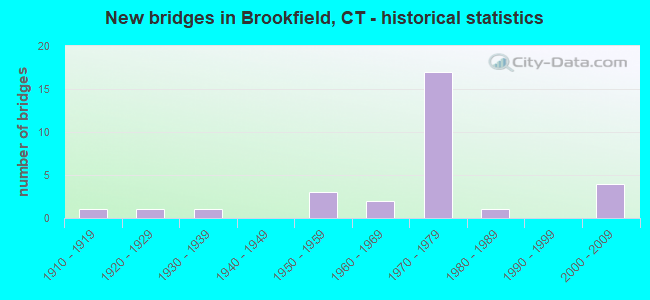
- New bridges - historical statistics
- 11910-1919
- 11920-1929
- 11930-1939
- 31950-1959
- 21960-1969
- 171970-1979
- 11980-1989
- 42000-2009

- Reconstructed bridges - Historical Statistics
- 11970-1979
- 21980-1989
- 01990-1999
- 02000-2009
- 02010-2019
- 12020-2022


- Bridge Condition - Deck
- 14.3%Very good
- 61.9%Good
- 23.8%Satisfactory

- Bridge Condition - Superstructure
- 13.0%Very good
- 39.1%Good
- 39.1%Satisfactory
- 8.7%Fair

- Bridge Condition - Substructure
- 59.1%Good
- 36.4%Satisfactory
- 4.5%Fair

- Bridge Condition - Channel
- 21.4%Very good
- 64.3%Good
- 14.3%Satisfactory
Find on map >> Show street view
Structure Number: 9, Location: ROUTE I 95 EXIT 3 (Lat: 41.019664, Lng: -73.626283), Route carried "on" structure: Interstate 95, Year Built: 1958, Status: Open, Structure Length: 2.15m (7.05ft), Average Daily Traffic: 117,800 (year 2017), Truck Traffic: 9%, Average Future Daily Traffic: 175,039 (year 2037), Design Load: HS 20, Features Intersected: ARCH STREET
Minimum Vertical Clearance: 30+ m (98+ ft), Kilometerpoint: 4.088, Lanes on structure: 6, Lanes under structure: 5, Base Highway Network: Yes, Owner: State Highway Agency, Approaching Roadway Width: 29.6m (97.1ft), Skew: 31 degrees, Material/Design: Steel, Design/Construction: Stringer/Multi-beam, Number Of Spans In Main Unit: 1, Length of Maximum Span: 20.0m (65.6ft), Curb-To-Curb Width: 36.0m (118.1ft), Out-to-Out Width: 38.9m (127.6ft)
Condition: Deck: Good, Superstructure: Good, Substructure: Satisfactory, Operating Rating: 95.6 metric tons, Method Used To Determine Operating Rating: Load Factor (LF), Inventory Rating: 57.4 metric tons, Method Used To Determine Inventory Rating: Load Factor (LF), Structural Evaluation: Equal to present minimum criteria, Deck Geometry: Superior to present desirable criteria, Underclear: High priority of corrective action, Approach Roadway Alignment: Equal to present desirable criteria, Designated Inspection Frequency: Every 24 months, Inspection Date: Febuary 2020, Deck Structure Type: Concrete Cast-file-Place, Wearing Surface/Protective System: Wearing Surface: Bituminous, Membrane: Preformed Fabric
Find on map >> Show street view
Structure Number: 392, Location: ROUTE 2 EXIT NO 16 (Lat: 41.591358, Lng: -72.393897), Route carried "on" structure: State highway 2, Year Built: 1959, Year Reconstructed: 1987, Status: Open, Structure Length: 4.43m (14.53ft), Average Daily Traffic: 17,100 (year 2018), Truck Traffic: 6%, Average Future Daily Traffic: 25,409 (year 2038), Design Load: HS 20, Features Intersected: ROUTE 149
Minimum Vertical Clearance: 30+ m (98+ ft), Kilometerpoint: 32.782, Lanes on structure: 2, Lanes under structure: 2, Base Highway Network: Yes, Owner: State Highway Agency, Approaching Roadway Width: 14.0m (45.9ft), Skew: 12 degrees, Material/Design: Steel, Design/Construction: Stringer/Multi-beam, Number Of Spans In Main Unit: 3, Length of Maximum Span: 18.3m (60.0ft), Curb-To-Curb Width: 14.0m (45.9ft), Out-to-Out Width: 15.2m (49.9ft)
Condition: Deck: Good, Superstructure: Fair, Substructure: Satisfactory, Operating Rating: 61.1 metric tons, Method Used To Determine Operating Rating: Load Factor (LF), Inventory Rating: 36.6 metric tons, Method Used To Determine Inventory Rating: Load Factor (LF), Structural Evaluation: Somewhat better than minimum adequacy, Deck Geometry: Superior to present desirable criteria, Underclear: Better than present minimum criteria, Approach Roadway Alignment: Equal to present desirable criteria, Designated Inspection Frequency: Every 24 months, Inspection Date: Febuary 2020, Deck Structure Type: Concrete Cast-file-Place, Wearing Surface/Protective System: Wearing Surface: Bituminous, Membrane: Preformed Fabric, Deck Protection: Epoxy Coated Reinforcing
Find on map >> Show street view
Structure Number: 9, Location: .1 MI EAST OF US RTE 202 (Lat: 41.482406, Lng: -73.408386), Route carried "on" structure: State highway 25, Year Built: 1920, Year Reconstructed: 1975, Status: Open, Structure Length: 1.37m (4.49ft), Average Daily Traffic: 8,700 (year 2016), Truck Traffic: 6%, Average Future Daily Traffic: 12,927 (year 2036), Features Intersected: STILL RIVER
Minimum Vertical Clearance: 30+ m (98+ ft), Kilometerpoint: 45.915, Lanes on structure: 2, Owner: State Highway Agency, Approaching Roadway Width: 8.5m (27.9ft), Material/Design: Masonry, Design/Construction: Arch - Deck, Number Of Spans In Main Unit: 1, Length of Maximum Span: 13.7m (44.9ft), Curb or Sidewalk Widths: Left: 0.0m, Right: 1.5m (4.9ft), Curb-To-Curb Width: 7.0m (23.0ft), Out-to-Out Width: 9.4m (30.8ft)
Condition: Superstructure: Satisfactory, Substructure: Satisfactory, Channel: Good, Operating Rating: 42.6 metric tons, Method Used To Determine Operating Rating: Field evaluation and documented engineering judgment, Inventory Rating: 32.7 metric tons, Method Used To Determine Inventory Rating: Field evaluation and documented engineering judgment, Structural Evaluation: Equal to present minimum criteria, Deck Geometry: High priority of replacement, Waterway Adequacy: Superior to present desirable criteria, Approach Roadway Alignment: Equal to present minimum criteria, Designated Inspection Frequency: Every 24 months, Inspection Date: March 2020, Wearing Surface/Protective System: Wearing Surface: Bituminous
Find on map >> Show street view
Structure Number: 1203, Location: BETWEEN EXITS 8 AND 9 (Lat: 41.424578, Lng: -73.377261), Route carried "on" structure: City street , Year Built: 1962, Status: Open, Structure Length: 6.49m (21.29ft), Average Daily Traffic: 815 (year 2021), Truck Traffic: 4%, Average Future Daily Traffic: 1,211 (year 2041), Design Load: HS 20, Features Intersected: INTERSTATE 84, Facility Carried by Structure: SECOR ROAD
Minimum Vertical Clearance: 30+ m (98+ ft), Kilometerpoint: 16.512, Lanes on structure: 2, Lanes under structure: 4, Owner: State Highway Agency, Approaching Roadway Width: 10.4m (34.1ft), Skew: 2 degrees, Material/Design: Steel, Design/Construction: Stringer/Multi-beam, Number Of Spans In Main Unit: 4, Length of Maximum Span: 21.0m (68.9ft), Curb or Sidewalk Widths: Left: 0.5m (1.6ft), Right: 0.5m (1.6ft), Curb-To-Curb Width: 10.4m (34.1ft), Out-to-Out Width: 12.1m (39.7ft)
Condition: Deck: Satisfactory, Superstructure: Satisfactory, Substructure: Satisfactory, Operating Rating: 44.4 metric tons, Method Used To Determine Operating Rating: Load and Resistance Factor Rating (LRFR) rating reported by rating factor(RF) method using HL-93 loadings, Inventory Rating: 34.3 metric tons, Method Used To Determine Inventory Rating: Load and Resistance Factor Rating (LRFR) rating reported by rating factor(RF) method using HL-93 loadings, Structural Evaluation: Equal to present minimum criteria, Deck Geometry: Equal to present minimum criteria, Underclear: Meets minimum limits, Approach Roadway Alignment: Equal to present desirable criteria, Designated Inspection Frequency: Every 24 months, Inspection Date: October 2021, Deck Structure Type: Concrete Cast-file-Place, Wearing Surface/Protective System: Wearing Surface: Bituminous, Membrane: Preformed Fabric
Find on map >> Show street view
Structure Number: 1343, Location: BRIDGEWATER/BROOKFIELD TN (Lat: 41.479553, Lng: -73.350683), Route carried "on" structure: State highway 133, Year Built: 1954, Year Reconstructed: 2020, Status: Open, Structure Length: 25.94m (85.10ft), Average Daily Traffic: 3,500 (year 2017), Truck Traffic: 5%, Average Future Daily Traffic: 5,201 (year 2037), Design Load: HS 20, Features Intersected: HOUSATONIC RIVER
Minimum Vertical Clearance: 4.17m (13.68ft), Kilometerpoint: 5.729, Lanes on structure: 2, Owner: State Highway Agency, Approaching Roadway Width: 8.8m (28.9ft), Material/Design: Steel, Design/Construction: Truss - Thru, Number Of Spans In Main Unit: 4, Length of Maximum Span: 63.4m (208.0ft), Curb-To-Curb Width: 8.8m (28.9ft), Out-to-Out Width: 10.0m (32.8ft)
Condition: Deck: Very good, Superstructure: Fair, Substructure: Satisfactory, Channel: Satisfactory, Operating Rating: 70.8 metric tons, Method Used To Determine Operating Rating: Load Factor (LF), Inventory Rating: 42.4 metric tons, Method Used To Determine Inventory Rating: Load Factor (LF), Structural Evaluation: Somewhat better than minimum adequacy, Deck Geometry: High priority of corrective action, Waterway Adequacy: Superior to present desirable criteria, Approach Roadway Alignment: Equal to present desirable criteria, Designated Inspection Frequency: Every 24 months, Critical Feature Inspection Frequency: Every 24 months, Inspection Date: April 2021, Critical Feature Inspection Date: April 2021, Deck Structure Type: Concrete Precast Panels, Wearing Surface/Protective System: Wearing Surface: Monolithic Concrete, Membrane: Built-up, Deck Protection: Epoxy Coated Reinforcing
Find on map >> Show street view
Structure Number: 3918, Location: RT 7 NORTH FED. ROAD EXIT (Lat: 41.432492, Lng: -73.411100), Route carried "on" structure: US 202, Year Built: 1976, Status: Open, Structure Length: 4.66m (15.29ft), Average Daily Traffic: 30,700 (year 2016), Truck Traffic: 6%, Average Future Daily Traffic: 45,617 (year 2036), Design Load: HS 20, Features Intersected: STILL RIVER
Minimum Vertical Clearance: 30+ m (98+ ft), Kilometerpoint: 14.436, Lanes on structure: 6, Owner: State Highway Agency, Approaching Roadway Width: 19.8m (65.0ft), Material/Design: Steel, Design/Construction: Stringer/Multi-beam, Number Of Spans In Main Unit: 1, Length of Maximum Span: 44.8m (147.0ft), Curb or Sidewalk Widths: Left: 1.7m (5.6ft), Right: 0.0m, Curb-To-Curb Width: 19.8m (65.0ft), Out-to-Out Width: 22.5m (73.8ft)
Condition: Deck: Good, Superstructure: Good, Substructure: Good, Channel: Good, Operating Rating: 65.1 metric tons, Method Used To Determine Operating Rating: Load and Resistance Factor Rating (LRFR) rating reported by rating factor(RF) method using HL-93 loadings, Inventory Rating: 50.2 metric tons, Method Used To Determine Inventory Rating: Load and Resistance Factor Rating (LRFR) rating reported by rating factor(RF) method using HL-93 loadings, Structural Evaluation: Better than present minimum criteria, Deck Geometry: High priority of replacement, Waterway Adequacy: Better than present minimum criteria, Approach Roadway Alignment: Equal to present desirable criteria, Designated Inspection Frequency: Every 24 months, Inspection Date: July 2020, Deck Structure Type: Concrete Cast-file-Place, Wearing Surface/Protective System: Wearing Surface: Bituminous, Membrane: Built-up
Find on map >> Show street view
Structure Number: 3919, Location: ROUTE 7 FEDERAL RD EXIT (Lat: 41.431211, Lng: -73.410717), Route carried "on" structure: US 7, Year Built: 1975, Status: Open, Structure Length: 4.91m (16.11ft), Average Daily Traffic: 12,200 (year 2018), Truck Traffic: 9%, Average Future Daily Traffic: 18,128 (year 2038), Design Load: HS 20, Features Intersected: US ROUTE 202
Minimum Vertical Clearance: 30+ m (98+ ft), Kilometerpoint: 42.728, Lanes on structure: 2, Lanes under structure: 5, Base Highway Network: Yes, Owner: State Highway Agency, Approaching Roadway Width: 12.8m (42.0ft), Skew: 3 degrees, Material/Design: Steel, Design/Construction: Stringer/Multi-beam, Number Of Spans In Main Unit: 1, Length of Maximum Span: 46.6m (152.9ft), Curb-To-Curb Width: 12.8m (42.0ft), Out-to-Out Width: 13.9m (45.6ft)
Condition: Deck: Satisfactory, Superstructure: Good, Substructure: Good, Operating Rating: 64.2 metric tons, Method Used To Determine Operating Rating: Load and Resistance Factor Rating (LRFR) rating reported by rating factor(RF) method using HL-93 loadings, Inventory Rating: 49.6 metric tons, Method Used To Determine Inventory Rating: Load and Resistance Factor Rating (LRFR) rating reported by rating factor(RF) method using HL-93 loadings, Structural Evaluation: Better than present minimum criteria, Deck Geometry: Equal to present desirable criteria, Underclear: High priority of corrective action, Approach Roadway Alignment: Equal to present desirable criteria, Designated Inspection Frequency: Every 24 months, Inspection Date: June 2021, Deck Structure Type: Concrete Cast-file-Place, Wearing Surface/Protective System: Wearing Surface: Bituminous, Membrane: Built-up
Find on map >> Show street view
Structure Number: 392, Location: AT RTE. 7 FEDERAL RD EXIT (Lat: 41.430847, Lng: -73.410550), Route carried "on" structure: US 7, Year Built: 1975, Status: Open, Structure Length: 4.94m (16.21ft), Average Daily Traffic: 9,700 (year 2018), Truck Traffic: 6%, Average Future Daily Traffic: 14,413 (year 2038), Design Load: HS 20, Features Intersected: US ROUTE 202
Minimum Vertical Clearance: 30+ m (98+ ft), Kilometerpoint: 42.712, Lanes on structure: 2, Lanes under structure: 6, Base Highway Network: Yes, Owner: State Highway Agency, Approaching Roadway Width: 13.1m (43.0ft), Skew: 3 degrees, Material/Design: Steel, Design/Construction: Stringer/Multi-beam, Number Of Spans In Main Unit: 1, Length of Maximum Span: 46.9m (153.9ft), Curb-To-Curb Width: 12.8m (42.0ft), Out-to-Out Width: 13.9m (45.6ft)
Condition: Deck: Good, Superstructure: Good, Substructure: Good, Operating Rating: 63.8 metric tons, Method Used To Determine Operating Rating: Load and Resistance Factor Rating (LRFR) rating reported by rating factor(RF) method using HL-93 loadings, Inventory Rating: 49.2 metric tons, Method Used To Determine Inventory Rating: Load and Resistance Factor Rating (LRFR) rating reported by rating factor(RF) method using HL-93 loadings, Structural Evaluation: Better than present minimum criteria, Deck Geometry: Equal to present desirable criteria, Underclear: High priority of corrective action, Approach Roadway Alignment: Equal to present desirable criteria, Designated Inspection Frequency: Every 24 months, Inspection Date: June 2021, Deck Structure Type: Concrete Cast-file-Place, Wearing Surface/Protective System: Wearing Surface: Bituminous, Membrane: Built-up
Find on map >> Show street view
Structure Number: 3921, Location: 0.6 MI NO OF FEDERAL RD (Lat: 41.439572, Lng: -73.400117), Route carried "on" structure: US 7, Year Built: 1976, Status: Open, Structure Length: 11.98m (39.30ft), Average Daily Traffic: 15,250 (year 2018), Truck Traffic: 6%, Average Future Daily Traffic: 22,660 (year 2038), Design Load: HS 20, Features Intersected: STILL RIV & GRAYS BR RD
Minimum Vertical Clearance: 30+ m (98+ ft), Kilometerpoint: 43.999, Lanes on structure: 2, Lanes under structure: 2, Base Highway Network: Yes, Owner: State Highway Agency, Approaching Roadway Width: 12.8m (42.0ft), Skew: 3 degrees, Material/Design: Steel continuous, Design/Construction: Stringer/Multi-beam, Number Of Spans In Main Unit: 2, Length of Maximum Span: 58.8m (192.9ft), Curb-To-Curb Width: 12.8m (42.0ft), Out-to-Out Width: 13.9m (45.6ft)
Condition: Deck: Satisfactory, Superstructure: Satisfactory, Substructure: Good, Channel: Good, Operating Rating: 59.0 metric tons, Method Used To Determine Operating Rating: Load and Resistance Factor Rating (LRFR) rating reported by rating factor(RF) method using HL-93 loadings, Inventory Rating: 45.7 metric tons, Method Used To Determine Inventory Rating: Load and Resistance Factor Rating (LRFR) rating reported by rating factor(RF) method using HL-93 loadings, Structural Evaluation: Equal to present minimum criteria, Deck Geometry: Equal to present desirable criteria, Underclear: Meets minimum limits, Waterway Adequacy: Superior to present desirable criteria, Approach Roadway Alignment: Equal to present desirable criteria, Designated Inspection Frequency: Every 24 months, Inspection Date: November 2020, Deck Structure Type: Concrete Cast-file-Place, Wearing Surface/Protective System: Wearing Surface: Bituminous, Membrane: Preformed Fabric
Find on map >> Show street view
Structure Number: 3923, Location: 1 MILE NE INT RTE 202 (Lat: 41.439883, Lng: -73.398356), Route carried "on" structure: City street , Year Built: 1975, Status: Open, Structure Length: 4.91m (16.11ft), Average Daily Traffic: 8,742 (year 2017), Truck Traffic: 5%, Average Future Daily Traffic: 12,990 (year 2037), Design Load: HS 20, Features Intersected: STILL RIVER, Facility Carried by Structure: GRAYS BRIDGE ROAD
Minimum Vertical Clearance: 30+ m (98+ ft), Kilometerpoint: 1.207, Lanes on structure: 2, Owner: Town or Township Highway Agency, Approaching Roadway Width: 10.4m (34.1ft), Skew: 3 degrees, Material/Design: Steel, Design/Construction: Stringer/Multi-beam, Number Of Spans In Main Unit: 1, Length of Maximum Span: 47.2m (154.9ft), Curb or Sidewalk Widths: Left: 2.4m (7.9ft), Right: 2.4m (7.9ft), Curb-To-Curb Width: 10.4m (34.1ft), Out-to-Out Width: 16.0m (52.5ft)
Condition: Deck: Good, Superstructure: Satisfactory, Substructure: Good, Channel: Satisfactory, Inventory Rating: 61.7 metric tons, Method Used To Determine Inventory Rating: Load Factor (LF), Structural Evaluation: Equal to present minimum criteria, Deck Geometry: Meets minimum limits, Waterway Adequacy: Superior to present desirable criteria, Approach Roadway Alignment: Equal to present desirable criteria, Designated Inspection Frequency: Every 24 months, Inspection Date: July 2021, Deck Structure Type: Concrete Cast-file-Place, Wearing Surface/Protective System: Wearing Surface: Bituminous, Membrane: Built-up
Find on map >> Show street view
Structure Number: 3924, Location: 2 MI. SOUTH OF RTE. 202 (Lat: 41.444036, Lng: -73.397203), Route carried "on" structure: US 7, Year Built: 1976, Status: Open, Structure Length: 6.04m (19.82ft), Average Daily Traffic: 15,250 (year 2018), Truck Traffic: 6%, Average Future Daily Traffic: 22,660 (year 2038), Design Load: HS 20, Features Intersected: STILL RIVER
Minimum Vertical Clearance: 30+ m (98+ ft), Kilometerpoint: 44.579, Lanes on structure: 2, Base Highway Network: Yes, Owner: State Highway Agency, Approaching Roadway Width: 13.1m (43.0ft), Skew: 4 degrees, Material/Design: Steel, Design/Construction: Stringer/Multi-beam, Number Of Spans In Main Unit: 1, Length of Maximum Span: 57.9m (190.0ft), Curb-To-Curb Width: 12.8m (42.0ft), Out-to-Out Width: 13.9m (45.6ft)
Condition: Deck: Good, Superstructure: Satisfactory, Substructure: Good, Channel: Good, Operating Rating: 64.8 metric tons, Method Used To Determine Operating Rating: Load and Resistance Factor Rating (LRFR) rating reported by rating factor(RF) method using HL-93 loadings, Inventory Rating: 49.9 metric tons, Method Used To Determine Inventory Rating: Load and Resistance Factor Rating (LRFR) rating reported by rating factor(RF) method using HL-93 loadings, Structural Evaluation: Equal to present minimum criteria, Deck Geometry: Equal to present desirable criteria, Waterway Adequacy: Superior to present desirable criteria, Approach Roadway Alignment: Equal to present desirable criteria, Designated Inspection Frequency: Every 24 months, Inspection Date: September 2020, Deck Structure Type: Concrete Cast-file-Place, Wearing Surface/Protective System: Wearing Surface: Bituminous, Membrane: Built-up
Find on map >> Show street view
Structure Number: 3925, Location: 1 MI NORTH OF FED RD EXT (Lat: 41.443656, Lng: -73.396878), Route carried "on" structure: US 7, Year Built: 1976, Status: Open, Structure Length: 5.97m (19.59ft), Average Daily Traffic: 15,250 (year 2018), Truck Traffic: 6%, Average Future Daily Traffic: 22,660 (year 2038), Design Load: HS 20, Features Intersected: STILL RIVER
Minimum Vertical Clearance: 30+ m (98+ ft), Kilometerpoint: 44.547, Lanes on structure: 2, Base Highway Network: Yes, Owner: State Highway Agency, Approaching Roadway Width: 13.1m (43.0ft), Skew: 3 degrees, Material/Design: Steel, Design/Construction: Stringer/Multi-beam, Number Of Spans In Main Unit: 1, Length of Maximum Span: 57.3m (188.0ft), Curb-To-Curb Width: 12.8m (42.0ft), Out-to-Out Width: 13.9m (45.6ft)
Condition: Deck: Good, Superstructure: Satisfactory, Substructure: Good, Channel: Good, Operating Rating: 68.4 metric tons, Method Used To Determine Operating Rating: Load and Resistance Factor Rating (LRFR) rating reported by rating factor(RF) method using HL-93 loadings, Inventory Rating: 52.8 metric tons, Method Used To Determine Inventory Rating: Load and Resistance Factor Rating (LRFR) rating reported by rating factor(RF) method using HL-93 loadings, Structural Evaluation: Equal to present minimum criteria, Deck Geometry: Equal to present desirable criteria, Waterway Adequacy: Superior to present desirable criteria, Approach Roadway Alignment: Equal to present desirable criteria, Designated Inspection Frequency: Every 24 months, Inspection Date: September 2020, Deck Structure Type: Concrete Cast-file-Place, Wearing Surface/Protective System: Wearing Surface: Bituminous, Membrane: Built-up
Find on map >> Show street view
Structure Number: 3926, Location: 1 MILES N OF FEDERAL ROAD (Lat: 41.456050, Lng: -73.396339), Route carried "on" structure: State highway 133, Year Built: 1976, Status: Open, Structure Length: 12.44m (40.81ft), Average Daily Traffic: 8,000 (year 2016), Truck Traffic: 5%, Average Future Daily Traffic: 11,887 (year 2036), Design Load: HS 20, Features Intersected: US ROUTE 7 & STILL RIVER
Minimum Vertical Clearance: 30+ m (98+ ft), Kilometerpoint: 0.515, Lanes on structure: 2, Lanes under structure: 4, Owner: State Highway Agency, Approaching Roadway Width: 12.2m (40.0ft), Material/Design: Steel continuous, Design/Construction: Stringer/Multi-beam, Number Of Spans In Main Unit: 3, Length of Maximum Span: 40.8m (133.9ft), Curb or Sidewalk Widths: Left: 2.3m (7.5ft), Right: 2.3m (7.5ft), Curb-To-Curb Width: 12.2m (40.0ft), Out-to-Out Width: 17.5m (57.4ft)
Condition: Deck: Good, Superstructure: Satisfactory, Substructure: Good, Channel: Good, Operating Rating: 55.1 metric tons, Method Used To Determine Operating Rating: Load and Resistance Factor Rating (LRFR) rating reported by rating factor(RF) method using HL-93 loadings, Inventory Rating: 42.4 metric tons, Method Used To Determine Inventory Rating: Load and Resistance Factor Rating (LRFR) rating reported by rating factor(RF) method using HL-93 loadings, Structural Evaluation: Equal to present minimum criteria, Deck Geometry: Somewhat better than minimum adequacy, Underclear: Better than present minimum criteria, Waterway Adequacy: Superior to present desirable criteria, Approach Roadway Alignment: Equal to present desirable criteria, Designated Inspection Frequency: Every 24 months, Inspection Date: January 2020, Deck Structure Type: Concrete Cast-file-Place, Wearing Surface/Protective System: Wearing Surface: Bituminous, Membrane: Built-up
Find on map >> Show street view
Structure Number: 3927, Location: .56 MI S OF US 202 JCT. (Lat: 41.466183, Lng: -73.403164), Route carried "on" structure: US 7, Year Built: 1975, Status: Open, Structure Length: 4.24m (13.91ft), Average Daily Traffic: 15,250 (year 2018), Truck Traffic: 6%, Average Future Daily Traffic: 22,660 (year 2038), Design Load: HS 20, Features Intersected: STILL RIVER
Minimum Vertical Clearance: 30+ m (98+ ft), Kilometerpoint: 47.266, Lanes on structure: 2, Base Highway Network: Yes, Owner: State Highway Agency, Approaching Roadway Width: 13.1m (43.0ft), Material/Design: Steel, Design/Construction: Stringer/Multi-beam, Number Of Spans In Main Unit: 1, Length of Maximum Span: 40.8m (133.9ft), Curb-To-Curb Width: 12.8m (42.0ft), Out-to-Out Width: 13.9m (45.6ft)
Condition: Deck: Good, Superstructure: Good, Substructure: Good, Channel: Good, Inventory Rating: 62.0 metric tons, Method Used To Determine Inventory Rating: Load Factor (LF), Structural Evaluation: Better than present minimum criteria, Deck Geometry: Equal to present desirable criteria, Waterway Adequacy: Equal to present desirable criteria, Approach Roadway Alignment: Equal to present desirable criteria, Designated Inspection Frequency: Every 24 months, Inspection Date: August 2020, Deck Structure Type: Concrete Cast-file-Place, Wearing Surface/Protective System: Wearing Surface: Bituminous, Membrane: Preformed Fabric
Find on map >> Show street view
Structure Number: 3928, Location: .55 MI S OF US 202 JCT. (Lat: 41.466372, Lng: -73.402761), Route carried "on" structure: US 7, Year Built: 1975, Status: Open, Structure Length: 4.24m (13.91ft), Average Daily Traffic: 15,250 (year 2018), Truck Traffic: 6%, Average Future Daily Traffic: 22,660 (year 2038), Design Load: HS 20, Features Intersected: STILL RIVER
Minimum Vertical Clearance: 30+ m (98+ ft), Kilometerpoint: 47.266, Lanes on structure: 2, Base Highway Network: Yes, Owner: State Highway Agency, Approaching Roadway Width: 13.1m (43.0ft), Material/Design: Steel, Design/Construction: Stringer/Multi-beam, Number Of Spans In Main Unit: 1, Length of Maximum Span: 40.8m (133.9ft), Curb-To-Curb Width: 12.8m (42.0ft), Out-to-Out Width: 13.9m (45.6ft)
Condition: Deck: Good, Superstructure: Good, Substructure: Good, Channel: Good, Operating Rating: 89.8 metric tons, Method Used To Determine Operating Rating: Load Factor (LF), Inventory Rating: 61.7 metric tons, Method Used To Determine Inventory Rating: Load Factor (LF), Structural Evaluation: Better than present minimum criteria, Deck Geometry: Equal to present desirable criteria, Waterway Adequacy: Equal to present desirable criteria, Approach Roadway Alignment: Equal to present desirable criteria, Designated Inspection Frequency: Every 24 months, Inspection Date: August 2020, Deck Structure Type: Concrete Cast-file-Place, Wearing Surface/Protective System: Wearing Surface: Bituminous, Membrane: Built-up
Find on map >> Show street view
Structure Number: 3929, Location: 0.9 MI N OF ROUTE 133 (Lat: 41.467733, Lng: -73.403553), Route carried "on" structure: City street , Year Built: 1976, Status: Open, Structure Length: 20.42m (66.99ft), Average Daily Traffic: 6,773 (year 2019), Truck Traffic: 4%, Average Future Daily Traffic: 10,064 (year 2039), Design Load: HS 20, Features Intersected: US ROUTE 7 & STILL RIVER, Facility Carried by Structure: SILVERMINE ROAD
Minimum Vertical Clearance: 30+ m (98+ ft), Kilometerpoint: 0.451, Lanes on structure: 2, Lanes under structure: 4, Owner: State Highway Agency, Approaching Roadway Width: 10.4m (34.1ft), Skew: 2 degrees, Material/Design: Steel continuous, Design/Construction: Stringer/Multi-beam, Number Of Spans In Main Unit: 4, Length of Maximum Span: 53.0m (173.9ft), Curb or Sidewalk Widths: Left: 2.4m (7.9ft), Right: 2.4m (7.9ft), Curb-To-Curb Width: 10.4m (34.1ft), Out-to-Out Width: 16.0m (52.5ft)
Condition: Deck: Satisfactory, Superstructure: Satisfactory, Substructure: Satisfactory, Channel: Good, Operating Rating: 67.7 metric tons, Method Used To Determine Operating Rating: Load and Resistance Factor Rating (LRFR) rating reported by rating factor(RF) method using HL-93 loadings, Inventory Rating: 52.2 metric tons, Method Used To Determine Inventory Rating: Load and Resistance Factor Rating (LRFR) rating reported by rating factor(RF) method using HL-93 loadings, Structural Evaluation: Equal to present minimum criteria, Deck Geometry: Meets minimum limits, Underclear: Somewhat better than minimum adequacy, Waterway Adequacy: Superior to present desirable criteria, Approach Roadway Alignment: Equal to present desirable criteria, Designated Inspection Frequency: Every 24 months, Inspection Date: March 2021, Deck Structure Type: Concrete Cast-file-Place, Wearing Surface/Protective System: Wearing Surface: Bituminous, Membrane: Built-up
Find on map >> Show street view
Structure Number: 393, Location: 1.3 MI N OF ROUTE 133 (Lat: 41.472228, Lng: -73.408267), Route carried "on" structure: US 202, Year Built: 1976, Status: Open, Structure Length: 8.72m (28.61ft), Average Daily Traffic: 17,400 (year 2016), Truck Traffic: 6%, Average Future Daily Traffic: 25,855 (year 2036), Design Load: HS 20, Features Intersected: US ROUTE 7
Minimum Vertical Clearance: 30+ m (98+ ft), Kilometerpoint: 19.183, Lanes on structure: 4, Lanes under structure: 4, Base Highway Network: Yes, Owner: State Highway Agency, Approaching Roadway Width: 15.9m (52.2ft), Skew: 3 degrees, Material/Design: Steel continuous, Design/Construction: Box Beam or Girders - Single/Spread, Number Of Spans In Main Unit: 2, Length of Maximum Span: 44.2m (145.0ft), Curb or Sidewalk Widths: Left: 2.7m (8.9ft), Right: 2.7m (8.9ft), Curb-To-Curb Width: 15.9m (52.2ft), Out-to-Out Width: 22.1m (72.5ft)
Condition: Deck: Satisfactory, Superstructure: Satisfactory, Substructure: Good, Operating Rating: 58.0 metric tons, Method Used To Determine Operating Rating: Load Factor (LF), Inventory Rating: 34.5 metric tons, Method Used To Determine Inventory Rating: Load Factor (LF), Structural Evaluation: Equal to present minimum criteria, Deck Geometry: Meets minimum limits, Underclear: Somewhat better than minimum adequacy, Approach Roadway Alignment: Equal to present minimum criteria, Designated Inspection Frequency: Every 24 months, Inspection Date: March 2021, Deck Structure Type: Concrete Cast-file-Place, Wearing Surface/Protective System: Wearing Surface: Bituminous, Membrane: Built-up
Find on map >> Show street view
Structure Number: 5747, Location: 0.5 mi east of US Rt 202 (Lat: 41.467906, Lng: -73.397403), Route carried "on" structure: City street , Year Built: 1910, Year Reconstructed: 1989, Status: Open, Structure Length: 3.44m (11.29ft), Average Daily Traffic: 3,978 (year 2021), Truck Traffic: 4%, Average Future Daily Traffic: 5,911 (year 2041), Design Load: HS 20, Features Intersected: HOUSATONIC RR, Facility Carried by Structure: SILVERMINE ROAD
Minimum Vertical Clearance: 30+ m (98+ ft), Kilometerpoint: 11.877, Lanes on structure: 2, Maintenance Responsibility: Local Agency, Approaching Roadway Width: 6.7m (22.0ft), Skew: 2 degrees, Material/Design: Steel continuous, Design/Construction: Stringer/Multi-beam, Number Of Spans In Main Unit: 3, Length of Maximum Span: 10.7m (35.1ft), Curb-To-Curb Width: 7.9m (25.9ft), Out-to-Out Width: 9.0m (29.5ft)
Condition: Deck: Good, Superstructure: Good, Substructure: Satisfactory, Operating Rating: 35.3 metric tons, Method Used To Determine Operating Rating: Load and Resistance Factor Rating (LRFR) rating reported by rating factor(RF) method using HL-93 loadings, Inventory Rating: 27.2 metric tons, Method Used To Determine Inventory Rating: Load and Resistance Factor Rating (LRFR) rating reported by rating factor(RF) method using HL-93 loadings, Structural Evaluation: Equal to present minimum criteria, Deck Geometry: High priority of corrective action, Underclear: High priority of corrective action, Approach Roadway Alignment: Equal to present desirable criteria, Designated Inspection Frequency: Every 24 months, Critical Feature Inspection Frequency: Every 24 months, Inspection Date: June 2021, Critical Feature Inspection Date: June 2021, Deck Structure Type: Concrete Cast-file-Place, Wearing Surface/Protective System: Wearing Surface: Bituminous, Membrane: Built-up, Deck Protection: Epoxy Coated Reinforcing
Find on map >> Show street view
Structure Number: 5776, Location: .25 MI EAST OF ROUTE 7 (Lat: 41.481094, Lng: -73.406447), Route carried "on" structure: State highway 25, Year Built: 1989, Status: Open, Structure Length: 2.04m (6.69ft), Average Daily Traffic: 4,200 (year 2013), Truck Traffic: 3%, Average Future Daily Traffic: 6,241 (year 2033), Design Load: HS 20, Features Intersected: HOUSATONIC RAILROAD
Minimum Vertical Clearance: 30+ m (98+ ft), Kilometerpoint: 45.673, Lanes on structure: 3, Owner: State Highway Agency, Approaching Roadway Width: 13.4m (44.0ft), Skew: 5 degrees, Material/Design: Steel, Design/Construction: Stringer/Multi-beam, Number Of Spans In Main Unit: 1, Length of Maximum Span: 18.6m (61.0ft), Curb or Sidewalk Widths: Left: 1.8m (5.9ft), Right: 0.0m, Curb-To-Curb Width: 13.4m (44.0ft), Out-to-Out Width: 16.2m (53.1ft)
Condition: Deck: Good, Superstructure: Good, Substructure: Good, Inventory Rating: 68.0 metric tons, Method Used To Determine Inventory Rating: Load Factor (LF), Structural Evaluation: Better than present minimum criteria, Deck Geometry: Somewhat better than minimum adequacy, Underclear: High priority of corrective action, Approach Roadway Alignment: Equal to present minimum criteria, Designated Inspection Frequency: Every 48 months, Inspection Date: November 2019, Deck Structure Type: Concrete Cast-file-Place, Wearing Surface/Protective System: Wearing Surface: Bituminous, Membrane: Preformed Fabric, Deck Protection: Epoxy Coated Reinforcing
Find on map >> Show street view
Structure Number: 6563, Location: 1/2 MI. SO. OF US RT. 202 (Lat: 41.477475, Lng: -73.411933), Route carried "on" structure: Bypass US 7, Year Built: 2009, Status: Open, Structure Length: 6.00m (19.69ft), Average Daily Traffic: 21,600 (year 2018), Truck Traffic: 7%, Average Future Daily Traffic: 32,095 (year 2038), Design Load: HS 20, Features Intersected: WETLAND 'A'
Minimum Vertical Clearance: 30+ m (98+ ft), Kilometerpoint: 48.361, Lanes on structure: 4, Owner: State Highway Agency, Approaching Roadway Width: 26.2m (86.0ft), Skew: 36 degrees, Material/Design: Steel, Design/Construction: Stringer/Multi-beam, Number Of Spans In Main Unit: 1, Length of Maximum Span: 58.5m (191.9ft), Curb-To-Curb Width: 25.2m (82.7ft), Out-to-Out Width: 27.1m (88.9ft)
Condition: Deck: Very good, Superstructure: Very good, Substructure: Good, Channel: Very good, Inventory Rating: 62.9 metric tons, Method Used To Determine Inventory Rating: Load Factor (LF), Structural Evaluation: Better than present minimum criteria, Deck Geometry: Superior to present desirable criteria, Waterway Adequacy: Equal to present desirable criteria, Approach Roadway Alignment: Equal to present desirable criteria, Designated Inspection Frequency: Every 24 months, Inspection Date: July 2021, Deck Structure Type: Concrete Cast-file-Place, Wearing Surface/Protective System: Wearing Surface: Bituminous, Membrane: Built-up, Deck Protection: Epoxy Coated Reinforcing
Find on map >> Show street view
Structure Number: 6564, Location: 1.26 MI NORTH O ROUTE 202 (Lat: 41.488953, Lng: -73.419017), Route carried "on" structure: Bypass US 7, Year Built: 2009, Status: Open, Structure Length: 13.20m (43.31ft), Average Daily Traffic: 25,900 (year 2018), Truck Traffic: 6%, Average Future Daily Traffic: 38,485 (year 2038), Design Load: HS 20, Features Intersected: TRIBUTARY BROOK/ WETLAND
Minimum Vertical Clearance: 30+ m (98+ ft), Kilometerpoint: 50.147, Lanes on structure: 4, Owner: State Highway Agency, Approaching Roadway Width: 25.6m (84.0ft), Material/Design: Steel continuous, Design/Construction: Stringer/Multi-beam, Number Of Spans In Main Unit: 2, Length of Maximum Span: 66.1m (216.9ft), Curb-To-Curb Width: 25.7m (84.3ft), Out-to-Out Width: 27.0m (88.6ft)
Condition: Deck: Very good, Superstructure: Very good, Substructure: Satisfactory, Channel: Very good, Operating Rating: 48.6 metric tons, Method Used To Determine Operating Rating: Load and Resistance Factor Rating (LRFR) rating reported by rating factor(RF) method using HL-93 loadings, Inventory Rating: 37.6 metric tons, Method Used To Determine Inventory Rating: Load and Resistance Factor Rating (LRFR) rating reported by rating factor(RF) method using HL-93 loadings, Structural Evaluation: Equal to present minimum criteria, Deck Geometry: Superior to present desirable criteria, Approach Roadway Alignment: Equal to present desirable criteria, Designated Inspection Frequency: Every 24 months, Inspection Date: October 2021, Deck Structure Type: Concrete Cast-file-Place, Wearing Surface/Protective System: Wearing Surface: Bituminous, Membrane: Built-up, Deck Protection: Epoxy Coated Reinforcing
Find on map >> Show street view
Structure Number: 6565, Location: STRUCTURE 18-113-3 (Lat: 41.486311, Lng: -73.418275), Route carried "on" structure: US 7, Year Built: 2009, Status: Open, Structure Length: 13.93m (45.70ft), Average Daily Traffic: 25,900 (year 2018), Truck Traffic: 6%, Average Future Daily Traffic: 38,485 (year 2038), Design Load: HS 20, Features Intersected: N MOUNTAIN RD & LIMEKILN
Minimum Vertical Clearance: 30+ m (98+ ft), Kilometerpoint: 49.857, Lanes on structure: 4, Lanes under structure: 2, Base Highway Network: Yes, Owner: State Highway Agency, Approaching Roadway Width: 26.2m (86.0ft), Material/Design: Steel continuous, Design/Construction: Stringer/Multi-beam, Number Of Spans In Main Unit: 3, Length of Maximum Span: 60.0m (196.9ft), Curb-To-Curb Width: 26.0m (85.3ft), Out-to-Out Width: 27.1m (88.9ft)
Condition: Deck: Good, Superstructure: Very good, Substructure: Fair, Channel: Very good, Operating Rating: 57.4 metric tons, Method Used To Determine Operating Rating: Load Factor (LF), Inventory Rating: 34.6 metric tons, Method Used To Determine Inventory Rating: Load Factor (LF), Structural Evaluation: Somewhat better than minimum adequacy, Deck Geometry: Superior to present desirable criteria, Underclear: Meets minimum limits, Approach Roadway Alignment: Equal to present desirable criteria, Designated Inspection Frequency: Every 24 months, Inspection Date: October 2021, Deck Structure Type: Concrete Cast-file-Place, Wearing Surface/Protective System: Wearing Surface: Bituminous, Membrane: Built-up, Deck Protection: Epoxy Coated Reinforcing
Find on map >> Show street view
Structure Number: 6761, Location: 2 MI. NORTH OF RTE. 202 (Lat: 41.493036, Lng: -73.419711), Route carried "on" structure: State highway 7, Year Built: 2009, Status: Open, Structure Length: 0.73m (2.40ft), Average Daily Traffic: 31,600 (year 2014), Truck Traffic: 5%, Average Future Daily Traffic: 46,954 (year 2034), Design Load: HS 20, Features Intersected: REPTILE CROSSING
Minimum Vertical Clearance: 30+ m (98+ ft), Kilometerpoint: 50.598, Lanes on structure: 4, Base Highway Network: Yes, Owner: State Highway Agency, Approaching Roadway Width: 12.8m (42.0ft), Material/Design: Concrete, Design/Construction: Frame, Number Of Spans In Main Unit: 1, Length of Maximum Span: 7.3m (24.0ft), Curb-To-Curb Width: 12.8m (42.0ft), Out-to-Out Width: 32.4m (106.3ft)
Condition: Superstructure: Good, Inventory Rating: 52.2 metric tons, Method Used To Determine Inventory Rating: Load Factor (LF), Structural Evaluation: Better than present minimum criteria, Deck Geometry: High priority of replacement, Approach Roadway Alignment: Equal to present desirable criteria, Designated Inspection Frequency: Every 48 months, Inspection Date: September 2019, Wearing Surface/Protective System: Wearing Surface: Bituminous
Find on map >> Show street view
Structure Number: 1203, Location: BETWEEN EXITS 8 AND 9 (Lat: 41.424578, Lng: -73.377261), Route carried "under" structure: Interstate 84, Year Built: 1962, Structure Length: 0. m, Average Daily Traffic: 82,500 (year 2018), Truck Traffic: 9%, Features Intersected: INTERSTATE 84, Facility Carried by Structure: SECOR ROAD
Minimum Vertical Clearance: 6.45m (21.16ft), Kilometerpoint: 16.512, Lanes on structure: 2, Lanes under structure: 4, Material/Design: Steel, Design/Construction: Stringer/Multi-beam, Length of Maximum Span: 21.0m (68.9ft)
Find on map >> Show street view
Structure Number: 1342, Location: JCT RT133 & STONY HILL RD (Lat: 41.456461, Lng: -73.393167), Route carried "under" structure: Alternate State highway 133, Year Built: 1933, Structure Length: 0. m, Average Daily Traffic: 6,800 (year 2015), Truck Traffic: 3%, Features Intersected: ROUTE 133, Facility Carried by Structure: HSTNC RR/ DNBY TRM
Minimum Vertical Clearance: 3.79m (12.43ft), Kilometerpoint: 0.837, Lanes under structure: 2, Material/Design: Steel, Design/Construction: Girder and Floorbeam System, Length of Maximum Span: 9.1m (29.9ft)
Find on map >> Show street view
Structure Number: 3919, Location: ROUTE 7 FEDERAL RD EXIT (Lat: 41.431211, Lng: -73.410717), Route carried "under" structure: US 202, Year Built: 1975, Structure Length: 0. m, Average Daily Traffic: 22,700 (year 2013), Truck Traffic: 5%, Features Intersected: US ROUTE 202, Facility Carried by Structure: US ROUTE 7 SB
Minimum Vertical Clearance: 5.36m (17.59ft), Kilometerpoint: 14.275, Lanes on structure: 2, Lanes under structure: 5, Material/Design: Steel, Design/Construction: Stringer/Multi-beam, Length of Maximum Span: 46.6m (152.9ft)
Find on map >> Show street view
Structure Number: 392, Location: AT RTE. 7 FEDERAL RD EXIT (Lat: 41.430847, Lng: -73.410550), Route carried "under" structure: US 202, Year Built: 1975, Structure Length: 0. m, Average Daily Traffic: 22,700 (year 2013), Truck Traffic: 5%, Features Intersected: US ROUTE 202, Facility Carried by Structure: US ROUTE 7 NB
Minimum Vertical Clearance: 5.21m (17.09ft), Kilometerpoint: 14.275, Lanes on structure: 2, Lanes under structure: 6, Material/Design: Steel, Design/Construction: Stringer/Multi-beam, Length of Maximum Span: 46.9m (153.9ft)
Find on map >> Show street view
Structure Number: 3926, Location: 1 MILES N OF FEDERAL ROAD (Lat: 41.456050, Lng: -73.396339), Route carried "under" structure: US 7, Year Built: 1976, Structure Length: 0. m, Average Daily Traffic: 30,500 (year 2018), Truck Traffic: 6%, Features Intersected: US ROUTE 7 & STILL RIVER, Facility Carried by Structure: ROUTE 133
Minimum Vertical Clearance: 5.44m (17.85ft), Kilometerpoint: 45.995, Lanes on structure: 2, Lanes under structure: 4, Material/Design: Steel continuous, Design/Construction: Stringer/Multi-beam, Length of Maximum Span: 40.8m (133.9ft)
Find on map >> Show street view
Structure Number: 3929, Location: 0.9 MI N OF ROUTE 133 (Lat: 41.467733, Lng: -73.403553), Route carried "under" structure: US 7, Year Built: 1976, Structure Length: 0. m, Average Daily Traffic: 30,500 (year 2018), Truck Traffic: 6%, Features Intersected: US ROUTE 7 & STILL RIVER, Facility Carried by Structure: SILVERMINE ROAD
Minimum Vertical Clearance: 5.82m (19.09ft), Kilometerpoint: 47.460, Lanes on structure: 2, Lanes under structure: 4, Material/Design: Steel continuous, Design/Construction: Stringer/Multi-beam, Length of Maximum Span: 53.0m (173.9ft)
Find on map >> Show street view
Structure Number: 393, Location: 1.3 MI N OF ROUTE 133 (Lat: 41.472228, Lng: -73.408267), Route carried "under" structure: US 7, Year Built: 1976, Structure Length: 0. m, Average Daily Traffic: 21,600 (year 2018), Truck Traffic: 6%, Features Intersected: US ROUTE 7, Facility Carried by Structure: US ROUTE 202
Minimum Vertical Clearance: 5.36m (17.59ft), Kilometerpoint: 48.087, Lanes on structure: 4, Lanes under structure: 4, Material/Design: Steel continuous, Design/Construction: Box Beam or Girders - Single/Spread, Length of Maximum Span: 44.2m (145.0ft)