Bridge Statistics for Brighton, Michigan (MI)
Condition, Traffic, Stress, Structural Evaluation, Project Costs
- National Bridge Inventory (NBI) Statistics
- 43Number of bridges
- 262ft / 80.2mTotal length
- 2,721,733Total average daily traffic
- 70,381Total average daily truck traffic
- National Bridge Inventory (NBI) Registered Bridges for Brighton
- No street view available for this location
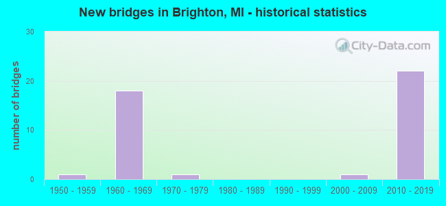
- New bridges - historical statistics
- 11950-1959
- 181960-1969
- 11970-1979
- 12000-2009
- 222010-2019

- Reconstructed bridges - Historical Statistics
- 11970-1979
- 01980-1989
- 01990-1999
- 12000-2009


- Bridge Condition - Deck
- 11.1%Very good
- 50.0%Good
- 16.7%Satisfactory
- 22.2%Fair

- Bridge Condition - Superstructure
- 22.2%Excellent
- 5.6%Very good
- 22.2%Good
- 27.8%Satisfactory
- 22.2%Fair

- Bridge Condition - Substructure
- 5.6%Excellent
- 33.3%Very good
- 22.2%Good
- 38.9%Satisfactory

- Bridge Condition - Channel
- 50.0%Good
- 50.0%Poor
Find on map >> Show street view
Structure Number: 5735, Location: 1.0 MI S OF I-96 (Lat: 42.505386, Lng: -83.757933), Route carried "on" structure: County highway , Year Built: 1962, Status: Open, Structure Length: 6.89m (22.60ft), Average Daily Traffic: 2,260 (year 1974), Truck Traffic: 3%, Average Future Daily Traffic: 2,260 (year 1977), Design Load: H 15, Features Intersected: US-23, Facility Carried by Structure: LEE RD
Minimum Vertical Clearance: 30.48m (100.00ft), Kilometerpoint: 0.555, Lanes on structure: 2, Lanes under structure: 5, Owner: State Highway Agency, Approaching Roadway Width: 7.9m (25.9ft), Skew: 3 degrees, Material/Design: Steel, Design/Construction: Stringer/Multi-beam, Number Of Spans In Main Unit: 4, Length of Maximum Span: 23.3m (76.4ft), Curb-To-Curb Width: 8.2m (26.9ft), Out-to-Out Width: 9.4m (30.8ft)
Condition: Deck: Fair, Superstructure: Satisfactory, Substructure: Satisfactory, Operating Rating: 56.4 metric tons, Method Used To Determine Operating Rating: Load Factor (LF) rating reported by rating factor (RF) method using MS18 loading, Inventory Rating: 33.7 metric tons, Method Used To Determine Inventory Rating: Load Factor (LF) rating reported by rating factor (RF) method using MS18 loading, Structural Evaluation: Equal to present minimum criteria, Deck Geometry: High priority of corrective action, Underclear: Meets minimum limits, Approach Roadway Alignment: Equal to present minimum criteria, Designated Inspection Frequency: Every 24 months, Inspection Date: July 2021, Deck Structure Type: Concrete Cast-file-Place, Wearing Surface/Protective System: Wearing Surface: Epoxy Overlay
Find on map >> Show street view
Structure Number: 5736, Location: 0.5 MI S OF I-96 (Lat: 42.520533, Lng: -83.757239), Route carried "on" structure: County highway 4740, Year Built: 1962, Year Reconstructed: 1984, Status: Open, Structure Length: 5.00m (16.40ft), Average Daily Traffic: 3,300 (year 1995), Truck Traffic: 3%, Average Future Daily Traffic: 3,300 (year 2015), Design Load: H 15, Features Intersected: US-23 SB, Facility Carried by Structure: GRAND RIVER AVE
Minimum Vertical Clearance: 30.48m (100.00ft), Kilometerpoint: 38.429, Lanes on structure: 4, Lanes under structure: 3, Owner: State Highway Agency, Approaching Roadway Width: 17.6m (57.7ft), Material/Design: Steel, Design/Construction: Stringer/Multi-beam, Number Of Spans In Main Unit: 3, Length of Maximum Span: 20.4m (66.9ft), Curb-To-Curb Width: 15.7m (51.5ft), Out-to-Out Width: 16.7m (54.8ft)
Condition: Deck: Satisfactory, Superstructure: Fair, Substructure: Satisfactory, Operating Rating: 54.1 metric tons, Method Used To Determine Operating Rating: Load Factor (LF) rating reported by rating factor (RF) method using MS18 loading, Inventory Rating: 28.5 metric tons, Method Used To Determine Inventory Rating: Load Factor (LF) rating reported by rating factor (RF) method using MS18 loading, Structural Evaluation: Somewhat better than minimum adequacy, Deck Geometry: Meets minimum limits, Underclear: High priority of corrective action, Approach Roadway Alignment: Equal to present minimum criteria, Designated Inspection Frequency: Every 24 months, Inspection Date: July 2021, Deck Structure Type: Concrete Cast-file-Place, Wearing Surface/Protective System: Wearing Surface: Latex Concrete
Find on map >> Show street view
Structure Number: 5737, Location: 0.5 MI S OF I-96 (Lat: 42.520067, Lng: -83.755000), Route carried "on" structure: County highway 4740, Year Built: 1962, Status: Open, Structure Length: 5.00m (16.40ft), Average Daily Traffic: 3,300 (year 1995), Average Future Daily Traffic: 3,300 (year 2015), Design Load: H 15, Features Intersected: US-23 NB, Facility Carried by Structure: GRAND RIVER AVE
Minimum Vertical Clearance: 30.48m (100.00ft), Kilometerpoint: 38.619, Lanes on structure: 4, Lanes under structure: 3, Owner: State Highway Agency, Approaching Roadway Width: 14.6m (47.9ft), Material/Design: Steel, Design/Construction: Stringer/Multi-beam, Number Of Spans In Main Unit: 3, Length of Maximum Span: 20.4m (66.9ft), Curb-To-Curb Width: 15.7m (51.5ft), Out-to-Out Width: 16.7m (54.8ft)
Condition: Deck: Satisfactory, Superstructure: Fair, Substructure: Satisfactory, Operating Rating: 53.1 metric tons, Method Used To Determine Operating Rating: Load Factor (LF) rating reported by rating factor (RF) method using MS18 loading, Inventory Rating: 28.2 metric tons, Method Used To Determine Inventory Rating: Load Factor (LF) rating reported by rating factor (RF) method using MS18 loading, Structural Evaluation: Somewhat better than minimum adequacy, Deck Geometry: Meets minimum limits, Underclear: High priority of corrective action, Approach Roadway Alignment: Equal to present minimum criteria, Designated Inspection Frequency: Every 24 months, Inspection Date: July 2021, Deck Structure Type: Concrete Cast-file-Place, Wearing Surface/Protective System: Wearing Surface: Latex Concrete, Deck Protection: Epoxy Coated Reinforcing
Find on map >> Show street view
Structure Number: 5745, Location: 0.9 MI N OF I-96 (Lat: 42.537619, Lng: -83.749689), Route carried "on" structure: County highway , Year Built: 1962, Status: Open, Structure Length: 7.27m (23.85ft), Average Daily Traffic: 1,580 (year 1995), Truck Traffic: 3%, Average Future Daily Traffic: 1,580 (year 2015), Design Load: H 15, Features Intersected: US-23, Facility Carried by Structure: SPENCER RD
Minimum Vertical Clearance: 30.48m (100.00ft), Kilometerpoint: 0.420, Lanes on structure: 2, Lanes under structure: 4, Owner: State Highway Agency, Approaching Roadway Width: 12.2m (40.0ft), Skew: 2 degrees, Material/Design: Steel, Design/Construction: Stringer/Multi-beam, Number Of Spans In Main Unit: 4, Length of Maximum Span: 22.6m (74.1ft), Curb-To-Curb Width: 9.8m (32.2ft), Out-to-Out Width: 10.7m (35.1ft)
Condition: Deck: Satisfactory, Superstructure: Satisfactory, Substructure: Satisfactory, Operating Rating: 52.8 metric tons, Method Used To Determine Operating Rating: Load Factor (LF) rating reported by rating factor (RF) method using MS18 loading, Inventory Rating: 27.2 metric tons, Method Used To Determine Inventory Rating: Load Factor (LF) rating reported by rating factor (RF) method using MS18 loading, Structural Evaluation: Equal to present minimum criteria, Deck Geometry: Somewhat better than minimum adequacy, Underclear: Somewhat better than minimum adequacy, Approach Roadway Alignment: Equal to present minimum criteria, Designated Inspection Frequency: Every 24 months, Inspection Date: August 2020, Deck Structure Type: Concrete Cast-file-Place, Wearing Surface/Protective System: Wearing Surface: Monolithic Concrete
Find on map >> Show street view
Structure Number: 5747, Location: 4.1 MI N OF I-96 (Lat: 42.582297, Lng: -83.738036), Route carried "on" structure: US 23, Year Built: 1962, Year Reconstructed: 2011, Status: Open, Structure Length: 3.26m (10.70ft), Average Daily Traffic: 25,275 (year 2007), Truck Traffic: 9%, Average Future Daily Traffic: 28,845 (year 2018), Design Load: HS 20, Features Intersected: HYNE RD
Minimum Vertical Clearance: 30.48m (100.00ft), Kilometerpoint: 17.758, Lanes on structure: 2, Lanes under structure: 2, Base Highway Network: Yes (Inventory Route: 93, Subroute: 2), Owner: State Highway Agency, Approaching Roadway Width: 13.7m (44.9ft), Material/Design: Steel, Design/Construction: Stringer/Multi-beam, Number Of Spans In Main Unit: 3, Length of Maximum Span: 12.5m (41.0ft), Curb-To-Curb Width: 13.4m (44.0ft), Out-to-Out Width: 14.4m (47.2ft)
Condition: Deck: Fair, Superstructure: Fair, Substructure: Satisfactory, Operating Rating: 62.2 metric tons, Method Used To Determine Operating Rating: Load Factor (LF), Inventory Rating: 37.2 metric tons, Method Used To Determine Inventory Rating: Load Factor (LF), Structural Evaluation: Somewhat better than minimum adequacy, Deck Geometry: Superior to present desirable criteria, Underclear: Meets minimum limits, Approach Roadway Alignment: Equal to present desirable criteria, Designated Inspection Frequency: Every 24 months, Inspection Date: August 2020, Deck Structure Type: Concrete Cast-file-Place, Wearing Surface/Protective System: Wearing Surface: Latex Concrete
Find on map >> Show street view
Structure Number: 5765, Location: @ US-23 (Lat: 42.523228, Lng: -83.756672), Route carried "on" structure: Interstate 96, Year Built: 2016, Status: Open, Structure Length: 3.30m (10.83ft), Average Daily Traffic: 36,361 (year 2012), Truck Traffic: 2%, Average Future Daily Traffic: 41,815 (year 2032), Design Load: Greater than HL93, Features Intersected: US-23 SB
Minimum Vertical Clearance: 30.48m (100.00ft), Kilometerpoint: 37.018, Lanes on structure: 2, Lanes under structure: 2, Base Highway Network: Yes (Inventory Route: 93, Subroute: 5), Owner: State Highway Agency, Approaching Roadway Width: 14.0m (45.9ft), Skew: 1 degrees, Material/Design: Prestressed concrete, Design/Construction: Stringer/Multi-beam, Number Of Spans In Main Unit: 1, Length of Maximum Span: 31.9m (104.7ft), Curb-To-Curb Width: 14.4m (47.2ft), Out-to-Out Width: 15.3m (50.2ft)
Condition: Deck: Very good, Superstructure: Excellent, Substructure: Very good, Operating Rating: 67.1 metric tons, Method Used To Determine Operating Rating: Load and Resistance Factor Rating (LRFR) rating reported by rating factor(RF) method using HL-93 loadings, Inventory Rating: 38.2 metric tons, Method Used To Determine Inventory Rating: Load and Resistance Factor Rating (LRFR) rating reported by rating factor(RF) method using HL-93 loadings, Structural Evaluation: Equal to present desirable criteria, Deck Geometry: Superior to present desirable criteria, Underclear: Superior to present desirable criteria, Approach Roadway Alignment: Equal to present desirable criteria, Designated Inspection Frequency: Every 24 months, Inspection Date: October 2020, Deck Structure Type: Concrete Cast-file-Place, Wearing Surface/Protective System: Wearing Surface: Monolithic Concrete, Deck Protection: Epoxy Coated Reinforcing
Find on map >> Show street view
Structure Number: 5766, Location: @ US-23 (Lat: 42.525753, Lng: -83.756067), Route carried "on" structure: Interstate 96, Year Built: 2016, Status: Open, Structure Length: 3.52m (11.55ft), Average Daily Traffic: 36,361 (year 2012), Truck Traffic: 2%, Average Future Daily Traffic: 41,815 (year 2032), Design Load: Greater than HL93, Features Intersected: US-23 SB
Minimum Vertical Clearance: 30.48m (100.00ft), Kilometerpoint: 37.026, Lanes on structure: 3, Lanes under structure: 4, Base Highway Network: Yes (Inventory Route: 93, Subroute: 7), Owner: State Highway Agency, Approaching Roadway Width: 19.4m (63.6ft), Material/Design: Prestressed concrete, Design/Construction: Stringer/Multi-beam, Number Of Spans In Main Unit: 1, Length of Maximum Span: 33.9m (111.2ft), Curb-To-Curb Width: 19.4m (63.6ft), Out-to-Out Width: 21.8m (71.5ft)
Condition: Deck: Good, Superstructure: Excellent, Substructure: Very good, Operating Rating: 58.0 metric tons, Method Used To Determine Operating Rating: Load and Resistance Factor Rating (LRFR) rating reported by rating factor(RF) method using HL-93 loadings, Inventory Rating: 28.8 metric tons, Method Used To Determine Inventory Rating: Load and Resistance Factor Rating (LRFR) rating reported by rating factor(RF) method using HL-93 loadings, Structural Evaluation: Better than present minimum criteria, Deck Geometry: Superior to present desirable criteria, Underclear: Better than present minimum criteria, Approach Roadway Alignment: Equal to present desirable criteria, Designated Inspection Frequency: Every 24 months, Inspection Date: October 2020, Deck Structure Type: Concrete Cast-file-Place, Wearing Surface/Protective System: Wearing Surface: Monolithic Concrete, Deck Protection: Epoxy Coated Reinforcing
Find on map >> Show street view
Structure Number: 5787, Location: 1.4 MI NW OF US-23 (Lat: 42.539347, Lng: -83.771953), Route carried "on" structure: City street , Year Built: 1962, Status: Open, Structure Length: 7.64m (25.07ft), Average Daily Traffic: 400 (year 1974), Truck Traffic: 3%, Average Future Daily Traffic: 400 (year 1977), Design Load: H 15, Features Intersected: I-96, Facility Carried by Structure: FLINT RD
Minimum Vertical Clearance: 30.48m (100.00ft), Kilometerpoint: 1.394, Lanes on structure: 2, Lanes under structure: 6, Owner: State Highway Agency, Approaching Roadway Width: 11.2m (36.7ft), Skew: 2 degrees, Material/Design: Steel, Design/Construction: Stringer/Multi-beam, Number Of Spans In Main Unit: 4, Length of Maximum Span: 23.7m (77.8ft), Curb-To-Curb Width: 8.8m (28.9ft), Out-to-Out Width: 9.8m (32.2ft)
Condition: Deck: Fair, Superstructure: Fair, Substructure: Satisfactory, Operating Rating: 55.1 metric tons, Method Used To Determine Operating Rating: Load Factor (LF) rating reported by rating factor (RF) method using MS18 loading, Inventory Rating: 28.2 metric tons, Method Used To Determine Inventory Rating: Load Factor (LF) rating reported by rating factor (RF) method using MS18 loading, Structural Evaluation: Somewhat better than minimum adequacy, Deck Geometry: Equal to present minimum criteria, Underclear: Meets minimum limits, Approach Roadway Alignment: Equal to present minimum criteria, Designated Inspection Frequency: Every 24 months, Inspection Date: May 2021, Bridge Improvement Cost: $181,000, Deck Structure Type: Concrete Cast-file-Place, Wearing Surface/Protective System: Wearing Surface: Monolithic Concrete
Find on map >> Show street view
Structure Number: 5789, Location: @ US-23 (Lat: 42.524567, Lng: -83.759594), Route carried "on" structure: Interstate 96, Year Built: 2016, Status: Open, Structure Length: 3.90m (12.80ft), Average Daily Traffic: 36,361 (year 2012), Truck Traffic: 2%, Average Future Daily Traffic: 41,815 (year 2032), Design Load: Greater than HL93, Features Intersected: OLD US-23
Minimum Vertical Clearance: 30.48m (100.00ft), Kilometerpoint: 36.735, Lanes on structure: 3, Lanes under structure: 2, Base Highway Network: Yes (Inventory Route: 93, Subroute: 5), Owner: State Highway Agency, Approaching Roadway Width: 16.5m (54.1ft), Skew: 4 degrees, Material/Design: Prestressed concrete, Design/Construction: Stringer/Multi-beam, Number Of Spans In Main Unit: 1, Length of Maximum Span: 37.7m (123.7ft), Curb-To-Curb Width: 17.8m (58.4ft), Out-to-Out Width: 19.1m (62.7ft)
Condition: Deck: Good, Superstructure: Very good, Substructure: Good, Operating Rating: 65.1 metric tons, Method Used To Determine Operating Rating: Load and Resistance Factor Rating (LRFR) rating reported by rating factor(RF) method using HL-93 loadings, Inventory Rating: 36.6 metric tons, Method Used To Determine Inventory Rating: Load and Resistance Factor Rating (LRFR) rating reported by rating factor(RF) method using HL-93 loadings, Structural Evaluation: Better than present minimum criteria, Deck Geometry: Better than present minimum criteria, Underclear: Equal to present minimum criteria, Approach Roadway Alignment: Equal to present desirable criteria, Designated Inspection Frequency: Every 24 months, Inspection Date: October 2020, Deck Structure Type: Concrete Cast-file-Place, Wearing Surface/Protective System: Wearing Surface: Monolithic Concrete, Deck Protection: Epoxy Coated Reinforcing
Find on map >> Show street view
Structure Number: 579, Location: @ US-23 (Lat: 42.526233, Lng: -83.759522), Route carried "on" structure: Interstate 96, Year Built: 2016, Status: Open, Structure Length: 3.11m (10.20ft), Average Daily Traffic: 36,361 (year 2012), Truck Traffic: 2%, Average Future Daily Traffic: 41,815 (year 2032), Design Load: Greater than HL93, Features Intersected: OLD US-23
Minimum Vertical Clearance: 30.48m (100.00ft), Kilometerpoint: 36.736, Lanes on structure: 3, Lanes under structure: 2, Base Highway Network: Yes (Inventory Route: 93, Subroute: 7), Owner: State Highway Agency, Approaching Roadway Width: 16.5m (54.1ft), Skew: 1 degrees, Material/Design: Prestressed concrete, Design/Construction: Stringer/Multi-beam, Number Of Spans In Main Unit: 1, Length of Maximum Span: 28.9m (94.8ft), Curb-To-Curb Width: 17.9m (58.7ft), Out-to-Out Width: 19.4m (63.6ft)
Condition: Deck: Good, Superstructure: Good, Substructure: Very good, Operating Rating: 62.5 metric tons, Method Used To Determine Operating Rating: Load and Resistance Factor Rating (LRFR) rating reported by rating factor(RF) method using HL-93 loadings, Inventory Rating: 44.4 metric tons, Method Used To Determine Inventory Rating: Load and Resistance Factor Rating (LRFR) rating reported by rating factor(RF) method using HL-93 loadings, Structural Evaluation: Better than present minimum criteria, Deck Geometry: Better than present minimum criteria, Underclear: Equal to present minimum criteria, Approach Roadway Alignment: Equal to present desirable criteria, Designated Inspection Frequency: Every 24 months, Inspection Date: October 2020, Deck Structure Type: Concrete Cast-file-Place, Wearing Surface/Protective System: Wearing Surface: Monolithic Concrete, Deck Protection: Epoxy Coated Reinforcing
Find on map >> Show street view
Structure Number: 5839, Location: SEC 12 HAMBURG TWP (Lat: 42.497686, Lng: -83.802183), Route carried "on" structure: County highway 4771, Year Built: 2003, Status: Open, Structure Length: 3.65m (11.98ft), Average Daily Traffic: 5,013 (year 2015), Truck Traffic: 2%, Average Future Daily Traffic: 5,270 (year 2035), Design Load: HS 25 or greater, Features Intersected: SOUTH ORE CREEK, Facility Carried by Structure: HAMBURG ROAD
Minimum Vertical Clearance: 30.48m (100.00ft), Kilometerpoint: 3.592, Lanes on structure: 2, Owner: County Highway Agency, Approaching Roadway Width: 13.1m (43.0ft), Skew: 3 degrees, Material/Design: Prestressed concrete, Design/Construction: Box Beam or Girders - Multiple, Number Of Spans In Main Unit: 1, Length of Maximum Span: 35.3m (115.8ft), Curb-To-Curb Width: 13.0m (42.7ft), Out-to-Out Width: 13.8m (45.3ft)
Condition: Deck: Very good, Superstructure: Satisfactory, Substructure: Good, Channel: Good, Operating Rating: 97.2 metric tons, Method Used To Determine Operating Rating: Load and Resistance Factor Rating (LRFR) rating reported by rating factor(RF) method using HL-93 loadings, Inventory Rating: 61.9 metric tons, Method Used To Determine Inventory Rating: Load and Resistance Factor Rating (LRFR) rating reported by rating factor(RF) method using HL-93 loadings, Structural Evaluation: Equal to present minimum criteria, Deck Geometry: Somewhat better than minimum adequacy, Waterway Adequacy: Equal to present desirable criteria, Approach Roadway Alignment: Somewhat better than minimum adequacy, Designated Inspection Frequency: Every 24 months, Inspection Date: November 2020, Deck Structure Type: Concrete Cast-file-Place, Wearing Surface/Protective System: Wearing Surface: Epoxy Overlay, Deck Protection: Epoxy Coated Reinforcing
Find on map >> Show street view
Structure Number: 13652, Location: @ US-23 INTERCHANGE (Lat: 42.524147, Lng: -83.756486), Route carried "on" structure: Interstate 96, Year Built: 2015, Status: Open, Structure Length: 5.30m (17.39ft), Average Daily Traffic: 363,610 (year 2012), Truck Traffic: 2%, Average Future Daily Traffic: 41,815 (year 2032), Design Load: Greater than HL93, Features Intersected: US-23 SB
Minimum Vertical Clearance: 30.48m (100.00ft), Kilometerpoint: 0.579, Lanes on structure: 2, Lanes under structure: 4, Base Highway Network: Yes (Inventory Route: 200, Subroute: 30), Owner: State Highway Agency, Approaching Roadway Width: 15.2m (49.9ft), Skew: 9 degrees, Material/Design: Prestressed concrete, Design/Construction: Stringer/Multi-beam, Number Of Spans In Main Unit: 1, Length of Maximum Span: 51.8m (169.9ft), Curb-To-Curb Width: 14.6m (47.9ft), Out-to-Out Width: 15.6m (51.2ft)
Condition: Deck: Good, Superstructure: Good, Substructure: Very good, Operating Rating: 60.6 metric tons, Method Used To Determine Operating Rating: Load and Resistance Factor Rating (LRFR) rating reported by rating factor(RF) method using HL-93 loadings, Inventory Rating: 32.4 metric tons, Method Used To Determine Inventory Rating: Load and Resistance Factor Rating (LRFR) rating reported by rating factor(RF) method using HL-93 loadings, Structural Evaluation: Better than present minimum criteria, Deck Geometry: Superior to present desirable criteria, Underclear: Superior to present desirable criteria, Approach Roadway Alignment: Superior to present desirable criteria, Designated Inspection Frequency: Every 24 months, Inspection Date: October 2021, Deck Structure Type: Concrete Cast-file-Place, Wearing Surface/Protective System: Wearing Surface: Monolithic Concrete, Deck Protection: Epoxy Coated Reinforcing
Find on map >> Show street view
Structure Number: 13653, Location: @ US-23 INTERCHANGE (Lat: 42.524614, Lng: -83.756369), Route carried "on" structure: Interstate 96, Year Built: 2015, Status: Open, Structure Length: 5.04m (16.54ft), Average Daily Traffic: 36,361 (year 2012), Truck Traffic: 2%, Average Future Daily Traffic: 41,815 (year 2032), Design Load: Greater than HL93, Features Intersected: US-23 SB
Minimum Vertical Clearance: 30.48m (100.00ft), Kilometerpoint: 0.610, Lanes on structure: 2, Lanes under structure: 4, Base Highway Network: Yes (Inventory Route: 200, Subroute: 31), Owner: State Highway Agency, Approaching Roadway Width: 15.2m (49.9ft), Skew: 9 degrees, Material/Design: Prestressed concrete, Design/Construction: Stringer/Multi-beam, Number Of Spans In Main Unit: 1, Length of Maximum Span: 49.3m (161.7ft), Curb-To-Curb Width: 14.8m (48.6ft), Out-to-Out Width: 15.8m (51.8ft)
Condition: Deck: Good, Superstructure: Good, Substructure: Very good, Operating Rating: 69.7 metric tons, Method Used To Determine Operating Rating: Load and Resistance Factor Rating (LRFR) rating reported by rating factor(RF) method using HL-93 loadings, Inventory Rating: 53.5 metric tons, Method Used To Determine Inventory Rating: Load and Resistance Factor Rating (LRFR) rating reported by rating factor(RF) method using HL-93 loadings, Structural Evaluation: Better than present minimum criteria, Deck Geometry: Superior to present desirable criteria, Underclear: Superior to present desirable criteria, Approach Roadway Alignment: Superior to present desirable criteria, Designated Inspection Frequency: Every 24 months, Inspection Date: October 2021, Deck Structure Type: Concrete Cast-file-Place, Wearing Surface/Protective System: Wearing Surface: Monolithic Concrete, Deck Protection: Epoxy Coated Reinforcing
Find on map >> Show street view
Structure Number: 13654, Location: @ US-23 INTERCHANGE (Lat: 42.523264, Lng: -83.752936), Route carried "on" structure: Interstate 96, Year Built: 2015, Status: Open, Structure Length: 4.19m (13.75ft), Average Daily Traffic: 36,361 (year 2012), Truck Traffic: 2%, Average Future Daily Traffic: 41,815 (year 2032), Design Load: Greater than HL93, Features Intersected: US-23 NB
Minimum Vertical Clearance: 30.48m (100.00ft), Kilometerpoint: 0.900, Lanes on structure: 2, Lanes under structure: 4, Base Highway Network: Yes (Inventory Route: 200, Subroute: 30), Owner: State Highway Agency, Approaching Roadway Width: 15.2m (49.9ft), Material/Design: Prestressed concrete, Design/Construction: Stringer/Multi-beam, Number Of Spans In Main Unit: 1, Length of Maximum Span: 41.1m (134.8ft), Curb-To-Curb Width: 14.6m (47.9ft), Out-to-Out Width: 15.6m (51.2ft)
Condition: Deck: Good, Superstructure: Satisfactory, Substructure: Good, Operating Rating: 50.9 metric tons, Method Used To Determine Operating Rating: Load and Resistance Factor Rating (LRFR) rating reported by rating factor(RF) method using HL-93 loadings, Inventory Rating: 39.9 metric tons, Method Used To Determine Inventory Rating: Load and Resistance Factor Rating (LRFR) rating reported by rating factor(RF) method using HL-93 loadings, Structural Evaluation: Equal to present minimum criteria, Deck Geometry: Superior to present desirable criteria, Underclear: Superior to present desirable criteria, Approach Roadway Alignment: Superior to present desirable criteria, Designated Inspection Frequency: Every 24 months, Inspection Date: October 2021, Deck Structure Type: Concrete Cast-file-Place, Wearing Surface/Protective System: Wearing Surface: Monolithic Concrete, Deck Protection: Epoxy Coated Reinforcing
Find on map >> Show street view
Structure Number: 13655, Location: @ US-23 (Lat: 42.523689, Lng: -83.752603), Route carried "on" structure: Interstate 96, Year Built: 2015, Status: Open, Structure Length: 4.31m (14.14ft), Average Daily Traffic: 36,361 (year 2012), Truck Traffic: 2%, Average Future Daily Traffic: 41,815 (year 2032), Design Load: Greater than HL93, Features Intersected: US-23 NB
Minimum Vertical Clearance: 30.48m (100.00ft), Kilometerpoint: 0.935, Lanes on structure: 2, Lanes under structure: 4, Base Highway Network: Yes (Inventory Route: 200, Subroute: 31), Owner: State Highway Agency, Approaching Roadway Width: 15.2m (49.9ft), Material/Design: Prestressed concrete, Design/Construction: Stringer/Multi-beam, Number Of Spans In Main Unit: 1, Length of Maximum Span: 42.3m (138.8ft), Curb-To-Curb Width: 14.6m (47.9ft), Out-to-Out Width: 15.6m (51.2ft)
Condition: Deck: Good, Superstructure: Satisfactory, Substructure: Good, Operating Rating: 52.2 metric tons, Method Used To Determine Operating Rating: Load and Resistance Factor Rating (LRFR) rating reported by rating factor(RF) method using HL-93 loadings, Inventory Rating: 40.2 metric tons, Method Used To Determine Inventory Rating: Load and Resistance Factor Rating (LRFR) rating reported by rating factor(RF) method using HL-93 loadings, Structural Evaluation: Equal to present minimum criteria, Deck Geometry: Superior to present desirable criteria, Underclear: Superior to present desirable criteria, Approach Roadway Alignment: Superior to present desirable criteria, Designated Inspection Frequency: Every 24 months, Inspection Date: October 2021, Deck Structure Type: Concrete Cast-file-Place, Wearing Surface/Protective System: Wearing Surface: Monolithic Concrete, Deck Protection: Epoxy Coated Reinforcing
Find on map >> Show street view
Structure Number: 13656, Location: @ US-23 INTERCHANGE (Lat: 42.525242, Lng: -83.759592), Route carried "on" structure: Interstate 96, Year Built: 2015, Status: Open, Structure Length: 3.42m (11.22ft), Average Daily Traffic: 36,361 (year 2012), Truck Traffic: 2%, Average Future Daily Traffic: 41,815 (year 2032), Design Load: Greater than HL93, Features Intersected: OLD US-23
Minimum Vertical Clearance: 30.48m (100.00ft), Kilometerpoint: 0.296, Lanes on structure: 2, Lanes under structure: 4, Base Highway Network: Yes (Inventory Route: 200, Subroute: 30), Owner: State Highway Agency, Approaching Roadway Width: 15.2m (49.9ft), Skew: 2 degrees, Material/Design: Prestressed concrete, Design/Construction: Stringer/Multi-beam, Number Of Spans In Main Unit: 1, Length of Maximum Span: 33.4m (109.6ft), Curb-To-Curb Width: 15.0m (49.2ft), Out-to-Out Width: 16.1m (52.8ft)
Condition: Deck: Good, Superstructure: Excellent, Substructure: Very good, Operating Rating: 68.0 metric tons, Method Used To Determine Operating Rating: Load and Resistance Factor Rating (LRFR) rating reported by rating factor(RF) method using HL-93 loadings, Inventory Rating: 52.5 metric tons, Method Used To Determine Inventory Rating: Load and Resistance Factor Rating (LRFR) rating reported by rating factor(RF) method using HL-93 loadings, Structural Evaluation: Equal to present desirable criteria, Deck Geometry: Superior to present desirable criteria, Underclear: Better than present minimum criteria, Approach Roadway Alignment: Superior to present desirable criteria, Designated Inspection Frequency: Every 24 months, Inspection Date: October 2021, Deck Structure Type: Concrete Cast-file-Place, Wearing Surface/Protective System: Wearing Surface: Monolithic Concrete, Deck Protection: Epoxy Coated Reinforcing
Find on map >> Show street view
Structure Number: 13657, Location: @ US -23 INTERCHANGE (Lat: 42.525697, Lng: -83.759569), Route carried "on" structure: Interstate 96, Year Built: 2015, Status: Open, Structure Length: 3.45m (11.32ft), Average Daily Traffic: 36,361 (year 2012), Truck Traffic: 2%, Average Future Daily Traffic: 41,815 (year 2032), Design Load: Greater than HL93, Features Intersected: OLD US-23
Minimum Vertical Clearance: 30.48m (100.00ft), Kilometerpoint: 0.322, Lanes on structure: 2, Lanes under structure: 4, Base Highway Network: Yes (Inventory Route: 200, Subroute: 31), Owner: State Highway Agency, Approaching Roadway Width: 15.2m (49.9ft), Skew: 3 degrees, Material/Design: Prestressed concrete, Design/Construction: Stringer/Multi-beam, Number Of Spans In Main Unit: 1, Length of Maximum Span: 33.6m (110.2ft), Curb-To-Curb Width: 15.2m (49.9ft), Out-to-Out Width: 16.2m (53.1ft)
Condition: Deck: Good, Superstructure: Excellent, Substructure: Excellent, Operating Rating: 66.7 metric tons, Method Used To Determine Operating Rating: Load and Resistance Factor Rating (LRFR) rating reported by rating factor(RF) method using HL-93 loadings, Inventory Rating: 51.5 metric tons, Method Used To Determine Inventory Rating: Load and Resistance Factor Rating (LRFR) rating reported by rating factor(RF) method using HL-93 loadings, Structural Evaluation: Superior to present desirable criteria, Deck Geometry: Superior to present desirable criteria, Underclear: Better than present minimum criteria, Approach Roadway Alignment: Superior to present desirable criteria, Designated Inspection Frequency: Every 24 months, Inspection Date: October 2021, Deck Structure Type: Concrete Cast-file-Place, Wearing Surface/Protective System: Wearing Surface: Monolithic Concrete, Deck Protection: Epoxy Coated Reinforcing
Find on map >> Show street view
Structure Number: 13706, Location: 3.7 MI SW PARK ENTRANCE (Lat: 42.495200, Lng: -83.734500), Route carried "on" structure: State lands road , Year Built: 1976, Status: Posted for load, Structure Length: 1.98m (6.50ft), Average Daily Traffic: 500 (year 2010), Average Future Daily Traffic: 575 (year 2030), Design Load: H 15, Features Intersected: HURON RIVER, Facility Carried by Structure: STATE PARKWAY
Minimum Vertical Clearance: 30.48m (100.00ft), Kilometerpoint: 5.924, Lanes on structure: 2, Owner: State Park, Forest, or Reservation Agency, Approaching Roadway Width: 7.9m (25.9ft), Skew: 4 degrees, Material/Design: Steel, Design/Construction: Stringer/Multi-beam, Number Of Spans In Main Unit: 1, Length of Maximum Span: 18.6m (61.0ft), Curb-To-Curb Width: 7.9m (25.9ft), Out-to-Out Width: 8.8m (28.9ft)
Condition: Deck: Fair, Superstructure: Good, Substructure: Satisfactory, Channel: Poor, Operating Rating: 44.7 metric tons, Method Used To Determine Operating Rating: Load Factor (LF) rating reported by rating factor (RF) method using MS18 loading, Inventory Rating: 26.9 metric tons, Method Used To Determine Inventory Rating: Load Factor (LF) rating reported by rating factor (RF) method using MS18 loading, Structural Evaluation: Equal to present minimum criteria, Deck Geometry: Somewhat better than minimum adequacy, Waterway Adequacy: Meets minimum limits, Approach Roadway Alignment: Equal to present minimum criteria, Bridge Posting: Required (Relationship of Operating Rating to Maximum Legal Load: 20.0 - 29.9% below), Designated Inspection Frequency: Every 24 months, Inspection Date: July 2021, Deck Structure Type: Concrete Cast-file-Place, Wearing Surface/Protective System: Wearing Surface: Monolithic Concrete
Find on map >> Show street view
Structure Number: 5735, Location: 1.0 MI S OF I-96 (Lat: 42.505386, Lng: -83.757933), Route carried "under" structure: US 23, Year Built: 1962, Structure Length: 0. m, Average Daily Traffic: 68,350 (year 2016), Truck Traffic: 8%, Features Intersected: US-23, Facility Carried by Structure: LEE RD
Minimum Vertical Clearance: 4.57m (14.99ft), Kilometerpoint: 8.863, Lanes on structure: 2, Lanes under structure: 5, Material/Design: Steel, Design/Construction: Stringer/Multi-beam, Length of Maximum Span: 23.3m (76.4ft)
Find on map >> Show street view
Structure Number: 5736, Location: 0.5 MI S OF I-96 (Lat: 42.520533, Lng: -83.757239), Route carried "under" structure: US 23, Year Built: 1962, Structure Length: 0. m, Average Daily Traffic: 32,868 (year 2007), Truck Traffic: 12%, Features Intersected: US-23 SB, Facility Carried by Structure: GRAND RIVER AVE
Minimum Vertical Clearance: 4.62m (15.16ft), Kilometerpoint: 10.558, Lanes on structure: 4, Lanes under structure: 3, Material/Design: Steel, Design/Construction: Stringer/Multi-beam, Length of Maximum Span: 20.4m (66.9ft)
Find on map >> Show street view
Structure Number: 5737, Location: 0.5 MI S OF I-96 (Lat: 42.520067, Lng: -83.755000), Route carried "under" structure: US 23, Year Built: 1962, Structure Length: 0. m, Average Daily Traffic: 32,868 (year 2007), Truck Traffic: 12%, Features Intersected: US-23 NB, Facility Carried by Structure: GRAND RIVER AVE
Minimum Vertical Clearance: 4.65m (15.26ft), Kilometerpoint: 10.543, Lanes on structure: 4, Lanes under structure: 3, Material/Design: Steel, Design/Construction: Stringer/Multi-beam, Length of Maximum Span: 20.4m (66.9ft)
Find on map >> Show street view
Structure Number: 5738, Location: 0.6 MI S OF I-96 (Lat: 42.511264, Lng: -83.758192), Route carried "under" structure: US 23, Year Built: 1961, Structure Length: 0. m, Average Daily Traffic: 65,736 (year 2007), Truck Traffic: 12%, Features Intersected: US-23, Facility Carried by Structure: CSX RR
Minimum Vertical Clearance: 4.60m (15.09ft), Kilometerpoint: 9.516, Lanes under structure: 4, Material/Design: Steel, Design/Construction: Girder and Floorbeam System, Length of Maximum Span: 23.4m (76.8ft)
Find on map >> Show street view
Structure Number: 5745, Location: 0.9 MI N OF I-96 (Lat: 42.537619, Lng: -83.749689), Route carried "under" structure: US 23, Year Built: 1962, Structure Length: 0. m, Average Daily Traffic: 52,600 (year 2011), Truck Traffic: 10%, Features Intersected: US-23, Facility Carried by Structure: SPENCER RD
Minimum Vertical Clearance: 4.44m (14.57ft), Kilometerpoint: 12.577, Lanes on structure: 2, Lanes under structure: 4, Material/Design: Steel, Design/Construction: Stringer/Multi-beam, Length of Maximum Span: 22.6m (74.1ft)
Find on map >> Show street view
Structure Number: 5746, Location: 4.1 MI N OF I-96 (Lat: 42.582306, Lng: -83.737675), Route carried "under" structure: County highway , Year Built: 1962, Structure Length: 0. m, Average Daily Traffic: 750 (year 0000), Features Intersected: HYNE RD, Facility Carried by Structure: US-23 NB
Minimum Vertical Clearance: 4.65m (15.26ft), Kilometerpoint: 2.940, Lanes on structure: 2, Lanes under structure: 2, Material/Design: Steel, Design/Construction: Stringer/Multi-beam, Length of Maximum Span: 12.5m (41.0ft)
Find on map >> Show street view
Structure Number: 5747, Location: 4.1 MI N OF I-96 (Lat: 42.582297, Lng: -83.738036), Route carried "under" structure: County highway , Year Built: 1962, Structure Length: 0. m, Average Daily Traffic: 750 (year 1974), Features Intersected: HYNE RD, Facility Carried by Structure: US-23 SB
Minimum Vertical Clearance: 4.55m (14.93ft), Kilometerpoint: 2.910, Lanes on structure: 2, Lanes under structure: 2, Material/Design: Steel, Design/Construction: Stringer/Multi-beam, Length of Maximum Span: 12.5m (41.0ft)
Find on map >> Show street view
Structure Number: 5765, Location: @ US-23 (Lat: 42.523228, Lng: -83.756672), Route carried "under" structure: US 23, Year Built: 2016, Structure Length: 0. m, Average Daily Traffic: 40,578 (year 2012), Truck Traffic: 2%, Features Intersected: US-23 SB, Facility Carried by Structure: I-96 EB CD
Minimum Vertical Clearance: 5.33m (17.49ft), Kilometerpoint: 10.860, Lanes on structure: 2, Lanes under structure: 2, Material/Design: Prestressed concrete, Design/Construction: Stringer/Multi-beam, Length of Maximum Span: 31.9m (104.7ft)
Find on map >> Show street view
Structure Number: 5766, Location: @ US-23 (Lat: 42.525753, Lng: -83.756067), Route carried "under" structure: US 23, Year Built: 2016, Structure Length: 0. m, Average Daily Traffic: 40,578 (year 2012), Truck Traffic: 2%, Features Intersected: US-23 SB, Facility Carried by Structure: I-96 WB CD
Minimum Vertical Clearance: 5.54m (18.18ft), Kilometerpoint: 11.145, Lanes on structure: 3, Lanes under structure: 4, Material/Design: Prestressed concrete, Design/Construction: Stringer/Multi-beam, Length of Maximum Span: 33.9m (111.2ft)
Find on map >> Show street view
Structure Number: 5767, Location: @ US-23 (Lat: 42.522517, Lng: -83.753347), Route carried "under" structure: US 23, Year Built: 2016, Structure Length: 0. m, Average Daily Traffic: 40,578 (year 2012), Truck Traffic: 2%, Features Intersected: US-23 NB, Facility Carried by Structure: I-96 EB CD
Minimum Vertical Clearance: 5.66m (18.57ft), Kilometerpoint: 10.847, Lanes on structure: 3, Lanes under structure: 4, Material/Design: Prestressed concrete, Design/Construction: Stringer/Multi-beam, Length of Maximum Span: 33.7m (110.6ft)
Find on map >> Show street view
Structure Number: 5768, Location: @ US-23 (Lat: 42.525236, Lng: -83.751958), Route carried "under" structure: Interstate 96, Year Built: 2016, Structure Length: 0. m, Average Daily Traffic: 36,361 (year 2012), Truck Traffic: 2%, Features Intersected: I-96 WB CD, Facility Carried by Structure: US-23 NB
Minimum Vertical Clearance: 5.21m (17.09ft), Kilometerpoint: 37.369, Lanes on structure: 3, Lanes under structure: 2, Material/Design: Prestressed concrete, Design/Construction: Stringer/Multi-beam, Length of Maximum Span: 30.3m (99.4ft)
Find on map >> Show street view
Structure Number: 5769, Location: 2.0 MI E OF US-23 (Lat: 42.522353, Lng: -83.720008), Route carried "under" structure: Interstate 96, Year Built: 1958, Structure Length: 0. m, Average Daily Traffic: 98,900 (year 2007), Truck Traffic: 8%, Features Intersected: I-96, Facility Carried by Structure: PLEASANT VALLEY RD
Minimum Vertical Clearance: 5.05m (16.57ft), Kilometerpoint: 40.048, Lanes on structure: 2, Lanes under structure: 6, Material/Design: Steel, Design/Construction: Stringer/Multi-beam, Length of Maximum Span: 20.0m (65.6ft)
Find on map >> Show street view
Structure Number: 5784, Location: 1.6 MI SE OF I-96 BL (Lat: 42.563536, Lng: -83.833953), Route carried "under" structure: Interstate 96, Year Built: 1961, Structure Length: 0. m, Average Daily Traffic: 75,498 (year 2007), Truck Traffic: 7%, Features Intersected: I-96, Facility Carried by Structure: DORR RD
Minimum Vertical Clearance: 5.00m (16.40ft), Kilometerpoint: 28.892, Lanes on structure: 2, Lanes under structure: 6, Material/Design: Steel, Design/Construction: Stringer/Multi-beam, Length of Maximum Span: 27.7m (90.9ft)
Find on map >> Show street view
Structure Number: 5785, Location: 2.4 MI NW OF US-23 (Lat: 42.547775, Lng: -83.789536), Route carried "under" structure: County highway 4740, Year Built: 1962, Structure Length: 0. m, Average Daily Traffic: 4,680 (year 1974), Features Intersected: GRAND RIVER AVE, Facility Carried by Structure: I-96 EB
Minimum Vertical Clearance: 4.67m (15.32ft), Kilometerpoint: 33.974, Lanes on structure: 4, Lanes under structure: 4, Material/Design: Steel, Design/Construction: Stringer/Multi-beam, Length of Maximum Span: 25.3m (83.0ft)
Find on map >> Show street view
Structure Number: 5786, Location: 2.4 MI NW OF US-23 (Lat: 42.548089, Lng: -83.789522), Route carried "under" structure: County highway 4740, Year Built: 1962, Structure Length: 0. m, Average Daily Traffic: 4,680 (year 1974), Features Intersected: GRAND RIVER AVE, Facility Carried by Structure: I-96 WB
Minimum Vertical Clearance: 4.93m (16.17ft), Kilometerpoint: 33.939, Lanes on structure: 4, Lanes under structure: 4, Material/Design: Steel, Design/Construction: Stringer/Multi-beam, Length of Maximum Span: 25.3m (83.0ft)
Find on map >> Show street view
Structure Number: 5787, Location: 1.4 MI NW OF US-23 (Lat: 42.539347, Lng: -83.771953), Route carried "under" structure: Interstate 96, Year Built: 1962, Structure Length: 0. m, Average Daily Traffic: 89,200 (year 2007), Truck Traffic: 8%, Features Intersected: I-96, Facility Carried by Structure: FLINT RD
Minimum Vertical Clearance: 6.10m (20.01ft), Kilometerpoint: 34.784, Lanes on structure: 2, Lanes under structure: 6, Material/Design: Steel, Design/Construction: Stringer/Multi-beam, Length of Maximum Span: 23.7m (77.8ft)
Find on map >> Show street view
Structure Number: 5788, Location: 0.8 MI NW OF US-23 (Lat: 42.532278, Lng: -83.766183), Route carried "under" structure: Interstate 96, Year Built: 1962, Structure Length: 0. m, Average Daily Traffic: 36,361 (year 2012), Truck Traffic: 2%, Features Intersected: I-96, Facility Carried by Structure: SPENCER RD
Minimum Vertical Clearance: 5.26m (17.26ft), Kilometerpoint: 35.709, Lanes on structure: 3, Lanes under structure: 9, Material/Design: Steel, Design/Construction: Stringer/Multi-beam, Length of Maximum Span: 24.4m (80.1ft)
Find on map >> Show street view
Structure Number: 5789, Location: @ US-23 (Lat: 42.524567, Lng: -83.759594), Route carried "under" structure: County highway 4783, Year Built: 2016, Structure Length: 0. m, Average Daily Traffic: 2,800 (year 1995), Features Intersected: OLD US-23, Facility Carried by Structure: I-96 EB CD
Minimum Vertical Clearance: 4.42m (14.50ft), Kilometerpoint: 11.319, Lanes on structure: 3, Lanes under structure: 2, Material/Design: Prestressed concrete, Design/Construction: Stringer/Multi-beam, Length of Maximum Span: 37.7m (123.7ft)
Find on map >> Show street view
Structure Number: 579, Location: @ US-23 (Lat: 42.526233, Lng: -83.759522), Route carried "under" structure: County highway 4783, Year Built: 2016, Structure Length: 0. m, Average Daily Traffic: 2,800 (year 1995), Features Intersected: OLD US-23, Facility Carried by Structure: I-96 WB CD
Minimum Vertical Clearance: 4.42m (14.50ft), Kilometerpoint: 11.504, Lanes on structure: 3, Lanes under structure: 2, Material/Design: Prestressed concrete, Design/Construction: Stringer/Multi-beam, Length of Maximum Span: 28.9m (94.8ft)
Find on map >> Show street view
Structure Number: 13652, Location: @ US-23 INTERCHANGE (Lat: 42.524147, Lng: -83.756486), Route carried "under" structure: US 23, Year Built: 2015, Structure Length: 0. m, Average Daily Traffic: 40,578 (year 2012), Truck Traffic: 2%, Features Intersected: US-23 SB, Facility Carried by Structure: I-96 EB
Minimum Vertical Clearance: 7.87m (25.82ft), Kilometerpoint: 10.981, Lanes on structure: 2, Lanes under structure: 4, Material/Design: Prestressed concrete, Design/Construction: Stringer/Multi-beam, Length of Maximum Span: 51.8m (169.9ft)
Find on map >> Show street view
Structure Number: 13653, Location: @ US-23 INTERCHANGE (Lat: 42.524614, Lng: -83.756369), Route carried "under" structure: US 23, Year Built: 2015, Structure Length: 0. m, Average Daily Traffic: 40,578 (year 2012), Truck Traffic: 2%, Features Intersected: US-23 SB, Facility Carried by Structure: I-96 WB
Minimum Vertical Clearance: 30+ m (98+ ft), Kilometerpoint: 10.997, Lanes on structure: 2, Lanes under structure: 4, Material/Design: Prestressed concrete, Design/Construction: Stringer/Multi-beam, Length of Maximum Span: 49.3m (161.7ft)
Find on map >> Show street view
Structure Number: 13654, Location: @ US-23 INTERCHANGE (Lat: 42.523264, Lng: -83.752936), Route carried "under" structure: US 23, Year Built: 2015, Structure Length: 0. m, Average Daily Traffic: 40,578 (year 2012), Truck Traffic: 2%, Features Intersected: US-23 NB, Facility Carried by Structure: I-96 EB
Minimum Vertical Clearance: 30+ m (98+ ft), Kilometerpoint: 10.970, Lanes on structure: 2, Lanes under structure: 4, Material/Design: Prestressed concrete, Design/Construction: Stringer/Multi-beam, Length of Maximum Span: 41.1m (134.8ft)
Find on map >> Show street view
Structure Number: 13655, Location: @ US-23 (Lat: 42.523689, Lng: -83.752603), Route carried "under" structure: US 23, Year Built: 2015, Structure Length: 0. m, Average Daily Traffic: 40,578 (year 2012), Truck Traffic: 2%, Features Intersected: US-23 NB, Facility Carried by Structure: I-96 WB
Minimum Vertical Clearance: 30+ m (98+ ft), Kilometerpoint: 10.986, Lanes on structure: 2, Lanes under structure: 4, Material/Design: Prestressed concrete, Design/Construction: Stringer/Multi-beam, Length of Maximum Span: 42.3m (138.8ft)
Find on map >> Show street view
Structure Number: 13656, Location: @ US-23 INTERCHANGE (Lat: 42.525242, Lng: -83.759592), Route carried "under" structure: County highway 4783, Year Built: 2015, Structure Length: 0. m, Average Daily Traffic: 99,999 (year 0000), Features Intersected: OLD US-23, Facility Carried by Structure: I-96 EB
Minimum Vertical Clearance: 5.54m (18.18ft), Kilometerpoint: 11.401, Lanes on structure: 2, Lanes under structure: 4, Material/Design: Prestressed concrete, Design/Construction: Stringer/Multi-beam, Length of Maximum Span: 33.4m (109.6ft)
Find on map >> Show street view
Structure Number: 13657, Location: @ US -23 INTERCHANGE (Lat: 42.525697, Lng: -83.759569), Route carried "under" structure: County highway 4783, Year Built: 2015, Structure Length: 0. m, Average Daily Traffic: 999,999 (year 0000), Features Intersected: OLD US-23, Facility Carried by Structure: I-96 WB
Minimum Vertical Clearance: 5.82m (19.09ft), Kilometerpoint: 11.424, Lanes on structure: 2, Lanes under structure: 4, Material/Design: Prestressed concrete, Design/Construction: Stringer/Multi-beam, Length of Maximum Span: 33.6m (110.2ft)