Bridge Statistics for Brandon, Florida (FL)
Condition, Traffic, Stress, Structural Evaluation, Project Costs
- National Bridge Inventory (NBI) Statistics
- 48Number of bridges
- 581ft / 177mTotal length
- $11,000Total costs
- 1,728,832Total average daily traffic
- 190,020Total average daily truck traffic
- National Bridge Inventory (NBI) Registered Bridges for Brandon
- No street view available for this location
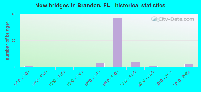
- New bridges - historical statistics
- 11930-1939
- 31970-1979
- 371980-1989
- 41990-1999
- 12000-2009
- 22020-2022

- Reconstructed bridges - Historical Statistics
- 11960-1969
- 01970-1979
- 01980-1989
- 01990-1999
- 12000-2009
- 02010-2019
- 32020-2022


- Bridge Condition - Deck
- 19.0%Very good
- 76.2%Good
- 4.8%Satisfactory

- Bridge Condition - Superstructure
- 19.0%Very good
- 81.0%Good

- Bridge Condition - Substructure
- 33.3%Very good
- 66.7%Good

- Bridge Condition - Channel
- 9.1%Very good
- 27.3%Good
- 54.5%Satisfactory
- 9.1%Fair

- Bridge Condition - Culverts
- 50.0%Good
- 33.3%Satisfactory
- 16.7%Fair
Find on map >> Show street view
Structure Number: 100101, Location: 0.3 MILE NORTH OF SR-60 (Lat: 27.953017, Lng: -82.354744), Route carried "on" structure: US 301, Year Built: 1970, Status: Open, Structure Length: 5.36m (17.59ft), Average Daily Traffic: 17,750 (year 2020), Truck Traffic: 13%, Average Future Daily Traffic: 30,796 (year 2042), Design Load: HL 93, Features Intersected: CSX RR
Minimum Vertical Clearance: 30+ m (98+ ft), Kilometerpoint: 36.592, Lanes on structure: 2, Base Highway Network: Yes, Owner: State Highway Agency, Approaching Roadway Width: 10.9m (35.8ft), Skew: 1 degrees, Material/Design: Prestressed concrete, Design/Construction: Stringer/Multi-beam, Number Of Spans In Main Unit: 4, Length of Maximum Span: 15.2m (49.9ft), Curb-To-Curb Width: 11.8m (38.7ft), Out-to-Out Width: 12.4m (40.7ft)
Condition: Deck: Good, Superstructure: Good, Substructure: Good, Operating Rating: 46.1 metric tons, Method Used To Determine Operating Rating: Load and Resistance Factor (LRFR), Inventory Rating: 35.6 metric tons, Method Used To Determine Inventory Rating: Load and Resistance Factor (LRFR), Structural Evaluation: Better than present minimum criteria, Deck Geometry: Better than present minimum criteria, Underclear: High priority of corrective action, Approach Roadway Alignment: Equal to present desirable criteria, Designated Inspection Frequency: Every 24 months, Inspection Date: March 2021, Deck Structure Type: Concrete Cast-file-Place
Find on map >> Show street view
Structure Number: 100421, Location: 0.8MI SOUTH OF SR-60 (Lat: 27.931972, Lng: -82.330786), Route carried "on" structure: Interstate 75, Year Built: 1985, Status: Open, Structure Length: 1.16m (3.81ft), Average Daily Traffic: 89,500 (year 2021), Truck Traffic: 11%, Average Future Daily Traffic: 155,282 (year 2041), Design Load: HS 20+Mod, Features Intersected: MEMORIAL GARDENS SLOUGH
Minimum Vertical Clearance: 30+ m (98+ ft), Kilometerpoint: 35.810, Lanes on structure: 12, Base Highway Network: Yes, Owner: State Highway Agency, Approaching Roadway Width: 69.5m (228.0ft), Skew: 20 degrees, Material/Design: Concrete, Design/Construction: Culvert, Number Of Spans In Main Unit: 3, Length of Maximum Span: 3.8m (12.5ft)
Condition: Channel: Satisfactory, Culverts: Satisfactory, Inventory Rating: 62.7 metric tons, Method Used To Determine Inventory Rating: Load Factor (LF), Structural Evaluation: Equal to present minimum criteria, Waterway Adequacy: Superior to present desirable criteria, Approach Roadway Alignment: Equal to present desirable criteria, Designated Inspection Frequency: Every 24 months, Inspection Date: October 2021
Find on map >> Show street view
Structure Number: 100468, Location: 0.9MI N OF SR-60 (Lat: 27.952222, Lng: -82.328086), Route carried "on" structure: Interstate 75, Year Built: 1983, Year Reconstructed: 2013, Status: Open, Structure Length: 4.90m (16.08ft), Average Daily Traffic: 70,750 (year 2021), Truck Traffic: 7%, Average Future Daily Traffic: 122,751 (year 2041), Design Load: HL 93, Features Intersected: WOODBERRY ROAD
Minimum Vertical Clearance: 30+ m (98+ ft), Kilometerpoint: 38.051, Lanes on structure: 3, Lanes under structure: 2, Base Highway Network: Yes, Owner: State Highway Agency, Approaching Roadway Width: 17.1m (56.1ft), Material/Design: Prestressed concrete, Design/Construction: Stringer/Multi-beam, Number Of Spans In Main Unit: 3, Length of Maximum Span: 27.4m (89.9ft), Curb-To-Curb Width: 17.1m (56.1ft), Out-to-Out Width: 18.0m (59.1ft)
Condition: Deck: Very good, Superstructure: Very good, Substructure: Very good, Operating Rating: 41.2 metric tons, Method Used To Determine Operating Rating: Load and Resistance Factor (LRFR), Inventory Rating: 37.2 metric tons, Method Used To Determine Inventory Rating: Load and Resistance Factor (LRFR), Structural Evaluation: Equal to present desirable criteria, Deck Geometry: Equal to present minimum criteria, Underclear: Superior to present desirable criteria, Approach Roadway Alignment: Equal to present desirable criteria, Designated Inspection Frequency: Every 24 months, Inspection Date: October 2021, Deck Structure Type: Concrete Cast-file-Place, Wearing Surface/Protective System: Wearing Surface: Monolithic Concrete
Find on map >> Show street view
Structure Number: 100469, Location: 0.9MI N OF SR-60 (Lat: 27.952225, Lng: -82.327692), Route carried "on" structure: Interstate 75, Year Built: 1983, Year Reconstructed: 2020, Status: Open, Structure Length: 4.88m (16.01ft), Average Daily Traffic: 70,750 (year 2021), Truck Traffic: 7%, Average Future Daily Traffic: 122,751 (year 2041), Design Load: HS 20+Mod, Features Intersected: WOODBERRY ROAD
Minimum Vertical Clearance: 30+ m (98+ ft), Kilometerpoint: 38.056, Lanes on structure: 3, Lanes under structure: 2, Base Highway Network: Yes, Owner: State Highway Agency, Approaching Roadway Width: 17.1m (56.1ft), Material/Design: Prestressed concrete, Design/Construction: Stringer/Multi-beam, Number Of Spans In Main Unit: 3, Length of Maximum Span: 27.1m (88.9ft), Curb-To-Curb Width: 17.1m (56.1ft), Out-to-Out Width: 18.0m (59.1ft)
Condition: Deck: Very good, Superstructure: Very good, Substructure: Good, Operating Rating: 53.9 metric tons, Method Used To Determine Operating Rating: Load and Resistance Factor (LRFR), Inventory Rating: 40.8 metric tons, Method Used To Determine Inventory Rating: Load and Resistance Factor (LRFR), Structural Evaluation: Better than present minimum criteria, Deck Geometry: Equal to present minimum criteria, Underclear: Better than present minimum criteria, Approach Roadway Alignment: Equal to present desirable criteria, Designated Inspection Frequency: Every 24 months, Inspection Date: October 2021, Deck Structure Type: Concrete Cast-file-Place
Find on map >> Show street view
Structure Number: 100471, Location: 0.6MI NORTH OF SR-60 (Lat: 27.950106, Lng: -82.328008), Route carried "on" structure: Interstate 75, Year Built: 1983, Year Reconstructed: 2020, Status: Open, Structure Length: 4.53m (14.86ft), Average Daily Traffic: 70,750 (year 2021), Truck Traffic: 7%, Average Future Daily Traffic: 122,751 (year 2041), Design Load: HS 20+Mod, Features Intersected: CSX RR
Minimum Vertical Clearance: 30+ m (98+ ft), Kilometerpoint: 37.826, Lanes on structure: 3, Base Highway Network: Yes, Owner: State Highway Agency, Approaching Roadway Width: 17.1m (56.1ft), Material/Design: Prestressed concrete, Design/Construction: Stringer/Multi-beam, Number Of Spans In Main Unit: 3, Length of Maximum Span: 15.1m (49.5ft), Curb-To-Curb Width: 17.1m (56.1ft), Out-to-Out Width: 18.0m (59.1ft)
Condition: Deck: Good, Superstructure: Very good, Substructure: Very good, Operating Rating: 67.0 metric tons, Method Used To Determine Operating Rating: Load and Resistance Factor (LRFR), Inventory Rating: 49.0 metric tons, Method Used To Determine Inventory Rating: Load and Resistance Factor (LRFR), Structural Evaluation: Equal to present desirable criteria, Deck Geometry: Equal to present minimum criteria, Underclear: Better than present minimum criteria, Approach Roadway Alignment: Equal to present desirable criteria, Designated Inspection Frequency: Every 24 months, Inspection Date: October 2021, Deck Structure Type: Concrete Cast-file-Place
Find on map >> Show street view
Structure Number: 100484, Location: 2MI SOUTH OF SR-618 (Lat: 27.902739, Lng: -82.343456), Route carried "on" structure: Ramp Interstate 75, Year Built: 1984, Status: Open, Structure Length: 9.75m (31.99ft), Average Daily Traffic: 5,900 (year 2021), Truck Traffic: 9%, Average Future Daily Traffic: 10,236 (year 2041), Design Load: HS 20+Mod, Features Intersected: US-301/SR-43
Minimum Vertical Clearance: 30+ m (98+ ft), Kilometerpoint: 0.484, Lanes on structure: 1, Lanes under structure: 8, Owner: State Highway Agency, Approaching Roadway Width: 6.4m (21.0ft), Skew: 5 degrees, Material/Design: Prestressed concrete, Design/Construction: Stringer/Multi-beam, Number Of Spans In Main Unit: 4, Length of Maximum Span: 34.8m (114.2ft), Curb-To-Curb Width: 8.3m (27.2ft), Out-to-Out Width: 9.1m (29.9ft)
Condition: Deck: Good, Superstructure: Good, Substructure: Very good, Operating Rating: 69.9 metric tons, Method Used To Determine Operating Rating: Load Factor (LF), Inventory Rating: 58.1 metric tons, Method Used To Determine Inventory Rating: Load Factor (LF), Structural Evaluation: Better than present minimum criteria, Deck Geometry: Superior to present desirable criteria, Underclear: Better than present minimum criteria, Approach Roadway Alignment: Equal to present desirable criteria, Designated Inspection Frequency: Every 24 months, Inspection Date: October 2021, Deck Structure Type: Concrete Cast-file-Place
Find on map >> Show street view
Structure Number: 100485, Location: 2MI SOUTH OF SR-618 (Lat: 27.903483, Lng: -82.343897), Route carried "on" structure: Interstate 75, Year Built: 1985, Status: Open, Structure Length: 9.75m (31.99ft), Average Daily Traffic: 71,750 (year 2021), Truck Traffic: 12%, Average Future Daily Traffic: 124,486 (year 2041), Design Load: HS 20+Mod, Features Intersected: US-301/SR-43
Minimum Vertical Clearance: 30+ m (98+ ft), Kilometerpoint: 32.338, Lanes on structure: 4, Lanes under structure: 8, Base Highway Network: Yes, Owner: State Highway Agency, Approaching Roadway Width: 20.9m (68.6ft), Skew: 3 degrees, Material/Design: Prestressed concrete, Design/Construction: Stringer/Multi-beam, Number Of Spans In Main Unit: 4, Length of Maximum Span: 34.6m (113.5ft), Curb-To-Curb Width: 20.9m (68.6ft), Out-to-Out Width: 21.8m (71.5ft)
Condition: Deck: Good, Superstructure: Good, Substructure: Good, Operating Rating: 60.8 metric tons, Method Used To Determine Operating Rating: Allowable Stress (AS), Inventory Rating: 49.0 metric tons, Method Used To Determine Inventory Rating: Allowable Stress (AS), Structural Evaluation: Better than present minimum criteria, Deck Geometry: Better than present minimum criteria, Underclear: Better than present minimum criteria, Approach Roadway Alignment: Equal to present desirable criteria, Length Of Structure Improvement: 0.97m (3.18ft), Designated Inspection Frequency: Every 24 months, Inspection Date: October 2021, Bridge Improvement Cost: $10,000, Roadway Improvement Cost: $1,000, Total Project Cost: $11,000, Deck Structure Type: Concrete Cast-file-Place
Find on map >> Show street view
Structure Number: 100487, Location: 0.9MI SOUTH OF SR-60 (Lat: 27.927539, Lng: -82.331483), Route carried "on" structure: State highway 618, Year Built: 1985, Status: Open, Structure Length: 15.48m (50.79ft), Average Daily Traffic: 42,500 (year 2021), Truck Traffic: 9%, Average Future Daily Traffic: 53,125 (year 2041), Design Load: HS 20+Mod, Features Intersected: I-75 (SR-93A)
Minimum Vertical Clearance: 30+ m (98+ ft), Kilometerpoint: 22.722, Lanes on structure: 1, Lanes under structure: 16, Toll: On toll road, Owner: State Highway Agency, Approaching Roadway Width: 8.2m (26.9ft), Material/Design: Prestressed concrete, Design/Construction: Stringer/Multi-beam, Number Of Spans In Main Unit: 4, Length of Maximum Span: 40.5m (132.9ft), Curb-To-Curb Width: 8.2m (26.9ft), Out-to-Out Width: 9.1m (29.9ft)
Condition: Deck: Good, Superstructure: Good, Substructure: Good, Operating Rating: 84.5 metric tons, Method Used To Determine Operating Rating: Load Factor (LF), Inventory Rating: 50.6 metric tons, Method Used To Determine Inventory Rating: Load Factor (LF), Structural Evaluation: Better than present minimum criteria, Deck Geometry: High priority of corrective action, Underclear: Better than present minimum criteria, Approach Roadway Alignment: Equal to present desirable criteria, Designated Inspection Frequency: Every 24 months, Inspection Date: October 2021, Deck Structure Type: Concrete Cast-file-Place
Find on map >> Show street view
Structure Number: 100488, Location: 0.8MI SOUTH OF SR-60 (Lat: 27.928222, Lng: -82.331289), Route carried "on" structure: State highway 618, Year Built: 1985, Status: Open, Structure Length: 15.17m (49.77ft), Average Daily Traffic: 21,250 (year 2021), Truck Traffic: 9%, Average Future Daily Traffic: 36,869 (year 2041), Design Load: HS 20+Mod, Features Intersected: I-75 (SR-93A)
Minimum Vertical Clearance: 30+ m (98+ ft), Kilometerpoint: 22.729, Lanes on structure: 2, Lanes under structure: 16, Toll: On toll road, Owner: State Highway Agency, Approaching Roadway Width: 12.2m (40.0ft), Material/Design: Prestressed concrete, Design/Construction: Stringer/Multi-beam, Number Of Spans In Main Unit: 4, Length of Maximum Span: 40.5m (132.9ft), Curb-To-Curb Width: 12.2m (40.0ft), Out-to-Out Width: 13.1m (43.0ft)
Condition: Deck: Good, Superstructure: Good, Substructure: Good, Operating Rating: 84.3 metric tons, Method Used To Determine Operating Rating: Load Factor (LF), Inventory Rating: 50.4 metric tons, Method Used To Determine Inventory Rating: Load Factor (LF), Structural Evaluation: Better than present minimum criteria, Deck Geometry: Better than present minimum criteria, Underclear: Equal to present minimum criteria, Approach Roadway Alignment: Equal to present desirable criteria, Designated Inspection Frequency: Every 24 months, Inspection Date: October 2021, Deck Structure Type: Concrete Cast-file-Place
Find on map >> Show street view
Structure Number: 100491, Location: 0.4MI NORTH OF US-301 (Lat: 27.908775, Lng: -82.339908), Route carried "on" structure: Ramp Interstate 75, Year Built: 1985, Status: Open, Structure Length: 8.11m (26.61ft), Average Daily Traffic: 21,500 (year 2021), Truck Traffic: 9%, Average Future Daily Traffic: 37,302 (year 2041), Design Load: HS 20+Mod, Features Intersected: I-75NB - SR618WB
Minimum Vertical Clearance: 30+ m (98+ ft), Kilometerpoint: 1.184, Lanes on structure: 2, Lanes under structure: 2, Owner: State Highway Agency, Approaching Roadway Width: 12.2m (40.0ft), Material/Design: Steel, Design/Construction: Box Beam or Girders - Single/Spread, Number Of Spans In Main Unit: 1, Length of Maximum Span: 81.1m (266.1ft), Curb-To-Curb Width: 12.2m (40.0ft), Out-to-Out Width: 13.3m (43.6ft)
Condition: Deck: Satisfactory, Superstructure: Good, Substructure: Good, Inventory Rating: 54.4 metric tons, Method Used To Determine Inventory Rating: Allowable Stress (AS), Structural Evaluation: Better than present minimum criteria, Deck Geometry: Superior to present desirable criteria, Underclear: Somewhat better than minimum adequacy, Approach Roadway Alignment: Equal to present desirable criteria, Designated Inspection Frequency: Every 24 months, Critical Feature Inspection Frequency: Every 12 months, Inspection Date: October 2021, Critical Feature Inspection Date: October 2021, Deck Structure Type: Concrete Cast-file-Place
Find on map >> Show street view
Structure Number: 100494, Location: INTERSECTION SR-60&I-75 (Lat: 27.941769, Lng: -82.329853), Route carried "on" structure: Ramp Interstate 75, Year Built: 1985, Year Reconstructed: 2020, Status: Open, Structure Length: 8.89m (29.17ft), Average Daily Traffic: 10,000 (year 2021), Truck Traffic: 9%, Average Future Daily Traffic: 17,350 (year 2041), Design Load: HS 20+Mod, Features Intersected: SR-60
Minimum Vertical Clearance: 30+ m (98+ ft), Kilometerpoint: 0.497, Lanes on structure: 2, Lanes under structure: 9, Owner: State Highway Agency, Approaching Roadway Width: 13.5m (44.3ft), Skew: 1 degrees, Material/Design: Prestressed concrete, Design/Construction: Stringer/Multi-beam, Number Of Spans In Main Unit: 4, Length of Maximum Span: 32.0m (105.0ft), Curb-To-Curb Width: 13.5m (44.3ft), Out-to-Out Width: 14.4m (47.2ft)
Condition: Deck: Good, Superstructure: Good, Substructure: Good, Operating Rating: 47.7 metric tons, Method Used To Determine Operating Rating: Load and Resistance Factor (LRFR), Inventory Rating: 32.7 metric tons, Method Used To Determine Inventory Rating: Load and Resistance Factor (LRFR), Structural Evaluation: Better than present minimum criteria, Deck Geometry: Superior to present desirable criteria, Underclear: Equal to present minimum criteria, Approach Roadway Alignment: Equal to present desirable criteria, Designated Inspection Frequency: Every 24 months, Inspection Date: October 2021, Deck Structure Type: Concrete Cast-file-Place
Find on map >> Show street view
Structure Number: 100495, Location: INTERSECTION SR-60&I-75 (Lat: 27.941647, Lng: -82.329594), Route carried "on" structure: Interstate 75, Year Built: 1985, Status: Open, Structure Length: 8.89m (29.17ft), Average Daily Traffic: 44,750 (year 2021), Truck Traffic: 11%, Average Future Daily Traffic: 77,641 (year 2041), Design Load: HS 20+Mod, Features Intersected: SR-60
Minimum Vertical Clearance: 30+ m (98+ ft), Kilometerpoint: 36.852, Lanes on structure: 3, Lanes under structure: 8, Base Highway Network: Yes, Owner: State Highway Agency, Approaching Roadway Width: 17.1m (56.1ft), Skew: 1 degrees, Material/Design: Prestressed concrete, Design/Construction: Stringer/Multi-beam, Number Of Spans In Main Unit: 4, Length of Maximum Span: 32.0m (105.0ft), Curb-To-Curb Width: 17.1m (56.1ft), Out-to-Out Width: 18.5m (60.7ft)
Condition: Deck: Good, Superstructure: Good, Substructure: Good, Operating Rating: 59.0 metric tons, Method Used To Determine Operating Rating: Allowable Stress (AS), Inventory Rating: 49.0 metric tons, Method Used To Determine Inventory Rating: Allowable Stress (AS), Structural Evaluation: Better than present minimum criteria, Deck Geometry: Equal to present minimum criteria, Underclear: Superior to present desirable criteria, Approach Roadway Alignment: Equal to present desirable criteria, Designated Inspection Frequency: Every 24 months, Inspection Date: October 2021, Deck Structure Type: Concrete Cast-file-Place
Find on map >> Show street view
Structure Number: 100496, Location: INTERSECTION SR-60&I-75 (Lat: 27.941528, Lng: -82.329203), Route carried "on" structure: Interstate 75, Year Built: 1985, Status: Open, Structure Length: 8.85m (29.04ft), Average Daily Traffic: 44,750 (year 2021), Truck Traffic: 11%, Average Future Daily Traffic: 77,641 (year 2041), Design Load: HS 20+Mod, Features Intersected: SR-60
Minimum Vertical Clearance: 30+ m (98+ ft), Kilometerpoint: 36.839, Lanes on structure: 4, Lanes under structure: 8, Base Highway Network: Yes, Owner: State Highway Agency, Approaching Roadway Width: 19.7m (64.6ft), Skew: 1 degrees, Material/Design: Prestressed concrete, Design/Construction: Stringer/Multi-beam, Number Of Spans In Main Unit: 4, Length of Maximum Span: 32.0m (105.0ft), Curb-To-Curb Width: 19.7m (64.6ft), Out-to-Out Width: 20.6m (67.6ft)
Condition: Deck: Good, Superstructure: Good, Substructure: Very good, Operating Rating: 59.0 metric tons, Method Used To Determine Operating Rating: Allowable Stress (AS), Inventory Rating: 49.9 metric tons, Method Used To Determine Inventory Rating: Allowable Stress (AS), Structural Evaluation: Better than present minimum criteria, Deck Geometry: Equal to present minimum criteria, Underclear: Better than present minimum criteria, Approach Roadway Alignment: Equal to present desirable criteria, Designated Inspection Frequency: Every 24 months, Inspection Date: October 2021, Deck Structure Type: Concrete Cast-file-Place
Find on map >> Show street view
Structure Number: 100497, Location: 1.3MI SOUTH OF SR-60 (Lat: 27.923011, Lng: -82.332922), Route carried "on" structure: County highway 676, Year Built: 1985, Status: Open, Structure Length: 22.48m (73.75ft), Average Daily Traffic: 25,500 (year 2021), Truck Traffic: 9%, Average Future Daily Traffic: 44,242 (year 2041), Design Load: HS 20+Mod, Features Intersected: I-75 (SR-93A), Facility Carried by Structure: CAUSEWAY BLVD
Minimum Vertical Clearance: 30.45m (99.90ft), Kilometerpoint: 1.568, Lanes on structure: 6, Lanes under structure: 14, Owner: State Highway Agency, Approaching Roadway Width: 34.8m (114.2ft), Skew: 22 degrees, Material/Design: Steel continuous, Design/Construction: Box Beam or Girders - Single/Spread, Number Of Spans In Main Unit: 5, Length of Maximum Span: 57.3m (188.0ft), Curb-To-Curb Width: 34.8m (114.2ft), Out-to-Out Width: 36.0m (118.1ft)
Condition: Deck: Good, Superstructure: Good, Substructure: Very good, Operating Rating: 73.2 metric tons, Method Used To Determine Operating Rating: Allowable Stress (AS), Inventory Rating: 35.4 metric tons, Method Used To Determine Inventory Rating: Allowable Stress (AS), Structural Evaluation: Better than present minimum criteria, Deck Geometry: Superior to present desirable criteria, Underclear: Equal to present minimum criteria, Approach Roadway Alignment: Equal to present desirable criteria, Designated Inspection Frequency: Every 24 months, Inspection Date: October 2021, Deck Structure Type: Concrete Cast-file-Place
Find on map >> Show street view
Structure Number: 100498, Location: 1.1MI SOUTH OF SR-60 (Lat: 27.925461, Lng: -82.333008), Route carried "on" structure: Ramp Interstate 75, Year Built: 1987, Status: Open, Structure Length: 8.71m (28.58ft), Average Daily Traffic: 27,000 (year 2021), Truck Traffic: 6%, Average Future Daily Traffic: 46,845 (year 2041), Design Load: HS 20+Mod, Features Intersected: SR618EB - I-75 SB
Minimum Vertical Clearance: 30+ m (98+ ft), Kilometerpoint: 0.000, Lanes on structure: 2, Lanes under structure: 2, Owner: State Highway Agency, Approaching Roadway Width: 12.3m (40.4ft), Material/Design: Steel, Design/Construction: Box Beam or Girders - Single/Spread, Number Of Spans In Main Unit: 1, Length of Maximum Span: 87.1m (285.8ft), Curb-To-Curb Width: 12.3m (40.4ft), Out-to-Out Width: 13.2m (43.3ft)
Condition: Deck: Good, Superstructure: Good, Substructure: Good, Operating Rating: 58.4 metric tons, Method Used To Determine Operating Rating: Load Factor (LF), Inventory Rating: 34.9 metric tons, Method Used To Determine Inventory Rating: Load Factor (LF), Structural Evaluation: Better than present minimum criteria, Deck Geometry: Superior to present desirable criteria, Underclear: Equal to present minimum criteria, Approach Roadway Alignment: Equal to present desirable criteria, Designated Inspection Frequency: Every 24 months, Critical Feature Inspection Frequency: Every 12 months, Inspection Date: October 2021, Critical Feature Inspection Date: October 2021, Deck Structure Type: Concrete Cast-file-Place
Find on map >> Show street view
Structure Number: 100502, Location: 0.8 MILE SOUTH OF SR-60 (Lat: 27.936736, Lng: -82.352675), Route carried "on" structure: US 301, Year Built: 1985, Status: Open, Structure Length: 1.22m (4.00ft), Average Daily Traffic: 37,000 (year 2020), Truck Traffic: 9%, Average Future Daily Traffic: 64,195 (year 2042), Design Load: HS 20+Mod, Features Intersected: DELANEY CREEK
Minimum Vertical Clearance: 30+ m (98+ ft), Kilometerpoint: 34.800, Lanes on structure: 4, Base Highway Network: Yes, Owner: State Highway Agency, Approaching Roadway Width: 16.9m (55.4ft), Skew: 22 degrees, Material/Design: Concrete, Design/Construction: Culvert, Number Of Spans In Main Unit: 3, Length of Maximum Span: 3.9m (12.8ft)
Condition: Channel: Fair, Culverts: Satisfactory, Operating Rating: 68.9 metric tons, Method Used To Determine Operating Rating: Load Factor (LF), Inventory Rating: 40.8 metric tons, Method Used To Determine Inventory Rating: Load Factor (LF), Structural Evaluation: Equal to present minimum criteria, Waterway Adequacy: Equal to present desirable criteria, Approach Roadway Alignment: Equal to present desirable criteria, Designated Inspection Frequency: Every 24 months, Inspection Date: March 2021
Find on map >> Show street view
Structure Number: 100574, Location: 0.4 MILE NORTH OF SR-60 (Lat: 27.955556, Lng: -82.355556), Route carried "on" structure: US 301, Year Built: 1973, Status: Open, Structure Length: 0.67m (2.20ft), Average Daily Traffic: 35,500 (year 2020), Truck Traffic: 13%, Average Future Daily Traffic: 61,592 (year 2042), Design Load: HS 20+Mod, Features Intersected: BRUCE CREEK
Minimum Vertical Clearance: 30+ m (98+ ft), Kilometerpoint: 36.925, Lanes on structure: 8, Base Highway Network: Yes, Owner: State Highway Agency, Approaching Roadway Width: 37.5m (123.0ft), Skew: 21 degrees, Material/Design: Concrete, Design/Construction: Culvert, Number Of Spans In Main Unit: 2, Length of Maximum Span: 3.3m (10.8ft)
Condition: Channel: Satisfactory, Culverts: Good, Structural Evaluation: Better than present minimum criteria, Waterway Adequacy: Equal to present minimum criteria, Approach Roadway Alignment: Better than present minimum criteria, Designated Inspection Frequency: Every 24 months, Inspection Date: March 2021
Find on map >> Show street view
Structure Number: 100595, Location: 0.5 MI E OF US-301 (Lat: 27.995325, Lng: -82.350747), Route carried "on" structure: Ramp US 92, Year Built: 2001, Status: Open, Structure Length: 16.01m (52.53ft), Average Daily Traffic: 8,600 (year 2021), Truck Traffic: 8%, Average Future Daily Traffic: 14,921 (year 2041), Design Load: HS 20+Mod, Features Intersected: TAMPA BYPASS CANAL
Minimum Vertical Clearance: 30+ m (98+ ft), Kilometerpoint: 2.173, Lanes on structure: 3, Owner: State Highway Agency, Approaching Roadway Width: 17.1m (56.1ft), Material/Design: Prestressed concrete, Design/Construction: Stringer/Multi-beam, Number Of Spans In Main Unit: 12, Length of Maximum Span: 13.3m (43.6ft), Curb-To-Curb Width: 17.1m (56.1ft), Out-to-Out Width: 18.0m (59.1ft)
Condition: Deck: Very good, Superstructure: Very good, Substructure: Very good, Channel: Good, Operating Rating: 73.3 metric tons, Method Used To Determine Operating Rating: Load Factor (LF), Inventory Rating: 43.8 metric tons, Method Used To Determine Inventory Rating: Load Factor (LF), Structural Evaluation: Equal to present desirable criteria, Deck Geometry: Superior to present desirable criteria, Waterway Adequacy: Equal to present desirable criteria, Approach Roadway Alignment: Equal to present desirable criteria, Designated Inspection Frequency: Every 24 months, Underwater Inspection Frequency: Every 24 months, Inspection Date: March 2021, Underwater Inspection Date: Febuary 2021, Deck Structure Type: Concrete Cast-file-Place
Find on map >> Show street view
Structure Number: 100851, Location: INTERSECTION SR-60 & I-75 (Lat: 27.941000, Lng: -82.329083), Route carried "on" structure: Ramp Interstate 75, Year Built: 2021, Status: Open, Structure Length: 8.28m (27.17ft), Average Daily Traffic: 21,900 (year 2021), Truck Traffic: 7%, Average Future Daily Traffic: 34,700 (year 2041), Design Load: HL 93, Features Intersected: SR-60
Minimum Vertical Clearance: 30+ m (98+ ft), Kilometerpoint: 36.835, Lanes on structure: 3, Lanes under structure: 8, Owner: State Highway Agency, Approaching Roadway Width: 13.7m (44.9ft), Skew: 1 degrees, Material/Design: Prestressed concrete, Design/Construction: Stringer/Multi-beam, Number Of Spans In Main Unit: 2, Length of Maximum Span: 49.6m (162.7ft), Curb-To-Curb Width: 13.7m (44.9ft), Out-to-Out Width: 14.0m (45.9ft)
Condition: Deck: Very good, Superstructure: Good, Substructure: Very good, Operating Rating: 50.0 metric tons, Method Used To Determine Operating Rating: Load and Resistance Factor (LRFR), Inventory Rating: 35.3 metric tons, Method Used To Determine Inventory Rating: Load and Resistance Factor (LRFR), Structural Evaluation: Better than present minimum criteria, Deck Geometry: Equal to present minimum criteria, Underclear: High priority of corrective action, Approach Roadway Alignment: Equal to present desirable criteria, Designated Inspection Frequency: Every 24 months, Inspection Date: Febuary 2021, Deck Structure Type: Concrete Cast-file-Place
Find on map >> Show street view
Structure Number: 10091, Location: 0.3 MILE NORTH OF SR-60 (Lat: 27.953042, Lng: -82.354881), Route carried "on" structure: US 301, Year Built: 1937, Year Reconstructed: 1971, Status: Open, Structure Length: 5.34m (17.52ft), Average Daily Traffic: 17,750 (year 2020), Truck Traffic: 13%, Average Future Daily Traffic: 30,796 (year 2042), Design Load: HL 93, Features Intersected: CSX RR
Minimum Vertical Clearance: 30+ m (98+ ft), Kilometerpoint: 36.598, Lanes on structure: 2, Base Highway Network: Yes, Owner: State Highway Agency, Approaching Roadway Width: 10.2m (33.5ft), Skew: 1 degrees, Material/Design: Concrete, Design/Construction: Tee Beam, Number Of Spans In Main Unit: 5, Length of Maximum Span: 10.7m (35.1ft), Curb-To-Curb Width: 11.8m (38.7ft), Out-to-Out Width: 12.4m (40.7ft)
Condition: Deck: Good, Superstructure: Good, Substructure: Good, Operating Rating: 43.4 metric tons, Method Used To Determine Operating Rating: Load and Resistance Factor (LRFR), Inventory Rating: 33.5 metric tons, Method Used To Determine Inventory Rating: Load and Resistance Factor (LRFR), Structural Evaluation: Better than present minimum criteria, Deck Geometry: Better than present minimum criteria, Underclear: High priority of corrective action, Approach Roadway Alignment: Equal to present desirable criteria, Designated Inspection Frequency: Every 24 months, Inspection Date: March 2021, Deck Structure Type: Concrete Cast-file-Place, Wearing Surface/Protective System: Wearing Surface: Bituminous
Find on map >> Show street view
Structure Number: 104103, Location: 75YDS EAST OF US-301 (Lat: 27.955914, Lng: -82.354881), Route carried "on" structure: County highway , Year Built: 1970, Status: Open, Structure Length: 0.93m (3.05ft), Average Daily Traffic: 750 (year 2022), Truck Traffic: 25%, Average Future Daily Traffic: 938 (year 2042), Design Load: H 15, Features Intersected: APEX CREEK, Facility Carried by Structure: OLD HOPEWELL RD
Minimum Vertical Clearance: 30+ m (98+ ft), Kilometerpoint: 0.000, Lanes on structure: 2, Owner: County Highway Agency, Approaching Roadway Width: 7.0m (23.0ft), Material/Design: Prestressed concrete, Design/Construction: Channel Beam, Number Of Spans In Main Unit: 1, Length of Maximum Span: 9.3m (30.5ft), Curb or Sidewalk Widths: Left: 0.6m (2.0ft), Right: 0.6m (2.0ft), Curb-To-Curb Width: 8.0m (26.2ft), Out-to-Out Width: 9.8m (32.2ft)
Condition: Deck: Good, Superstructure: Good, Substructure: Good, Channel: Satisfactory, Operating Rating: 51.4 metric tons, Method Used To Determine Operating Rating: Load Factor (LF), Inventory Rating: 28.0 metric tons, Method Used To Determine Inventory Rating: Load Factor (LF), Structural Evaluation: Better than present minimum criteria, Deck Geometry: Somewhat better than minimum adequacy, Waterway Adequacy: Better than present minimum criteria, Approach Roadway Alignment: Equal to present minimum criteria, Designated Inspection Frequency: Every 24 months, Inspection Date: January 2022, Deck Structure Type: Concrete Cast-file-Place, Wearing Surface/Protective System: Wearing Surface: Epoxy Overlay
Find on map >> Show street view
Structure Number: 104138, Location: 3.3 MI. EAST OF US-301 (Lat: 27.893367, Lng: -82.284194), Route carried "on" structure: Other road , Year Built: 1986, Status: Open, Structure Length: 0.67m (2.20ft), Average Daily Traffic: 1,090 (year 2020), Truck Traffic: 1%, Average Future Daily Traffic: 1,362 (year 2040), Design Load: HS 20, Features Intersected: BUCKHORN CREEK, Facility Carried by Structure: BLOOMINGDALE PLAZA
Minimum Vertical Clearance: 30+ m (98+ ft), Kilometerpoint: 0.000, Lanes on structure: 2, Owner: County Highway Agency, Approaching Roadway Width: 10.1m (33.1ft), Skew: 1 degrees, Material/Design: Steel, Design/Construction: Culvert, Number Of Spans In Main Unit: 2, Length of Maximum Span: 3.0m (9.8ft)
Condition: Channel: Satisfactory, Culverts: Fair, Structural Evaluation: Somewhat better than minimum adequacy, Waterway Adequacy: Better than present minimum criteria, Approach Roadway Alignment: Better than present minimum criteria, Designated Inspection Frequency: Every 24 months, Inspection Date: April 2020
Find on map >> Show street view
Structure Number: 104141, Location: 0.2MI N/O BLOOMINGDALE AV (Lat: 27.896953, Lng: -82.293975), Route carried "on" structure: County highway , Year Built: 1993, Status: Open, Structure Length: 1.65m (5.41ft), Average Daily Traffic: 11,300 (year 2020), Truck Traffic: 5%, Average Future Daily Traffic: 14,125 (year 2040), Design Load: HS 20, Features Intersected: BUCKHORN CREEK, Facility Carried by Structure: KINGS AVE.
Minimum Vertical Clearance: 30+ m (98+ ft), Kilometerpoint: 1.979, Lanes on structure: 4, Owner: County Highway Agency, Approaching Roadway Width: 17.1m (56.1ft), Skew: 20 degrees, Material/Design: Prestressed concrete, Design/Construction: Stringer/Multi-beam, Number Of Spans In Main Unit: 1, Length of Maximum Span: 16.5m (54.1ft), Curb or Sidewalk Widths: Left: 1.5m (4.9ft), Right: 1.5m (4.9ft), Curb-To-Curb Width: 19.8m (65.0ft), Out-to-Out Width: 26.6m (87.3ft)
Condition: Deck: Good, Superstructure: Good, Substructure: Good, Channel: Very good, Operating Rating: 82.2 metric tons, Method Used To Determine Operating Rating: Load Factor (LF), Inventory Rating: 49.3 metric tons, Method Used To Determine Inventory Rating: Load Factor (LF), Structural Evaluation: Better than present minimum criteria, Deck Geometry: Better than present minimum criteria, Waterway Adequacy: Equal to present desirable criteria, Approach Roadway Alignment: Equal to present desirable criteria, Designated Inspection Frequency: Every 24 months, Inspection Date: April 2020, Deck Structure Type: Concrete Cast-file-Place
Find on map >> Show street view
Structure Number: 104142, Location: 2.4MI. EAST OF US-301 (Lat: 27.893642, Lng: -82.298547), Route carried "on" structure: County highway , Year Built: 1997, Status: Open, Structure Length: 2.35m (7.71ft), Average Daily Traffic: 17,000 (year 2020), Truck Traffic: 4%, Average Future Daily Traffic: 21,250 (year 2040), Design Load: HS 20, Features Intersected: BUCKHORN CREEK, Facility Carried by Structure: BLOOMINGDALE AVE.
Minimum Vertical Clearance: 30+ m (98+ ft), Kilometerpoint: 3.854, Lanes on structure: 4, Owner: County Highway Agency, Approaching Roadway Width: 19.5m (64.0ft), Skew: 1 degrees, Material/Design: Prestressed concrete, Design/Construction: Stringer/Multi-beam, Number Of Spans In Main Unit: 1, Length of Maximum Span: 23.5m (77.1ft), Curb or Sidewalk Widths: Left: 1.6m (5.2ft), Right: 1.6m (5.2ft), Curb-To-Curb Width: 20.5m (67.3ft), Out-to-Out Width: 25.1m (82.3ft)
Condition: Deck: Good, Superstructure: Good, Substructure: Good, Channel: Satisfactory, Operating Rating: 63.4 metric tons, Method Used To Determine Operating Rating: Load Factor (LF), Inventory Rating: 38.0 metric tons, Method Used To Determine Inventory Rating: Load Factor (LF), Structural Evaluation: Better than present minimum criteria, Deck Geometry: Superior to present desirable criteria, Waterway Adequacy: Better than present minimum criteria, Approach Roadway Alignment: Equal to present desirable criteria, Designated Inspection Frequency: Every 24 months, Inspection Date: April 2020, Deck Structure Type: Concrete Cast-file-Place
Find on map >> Show street view
Structure Number: 104145, Location: 3.2MI. EAST OF US-301 (Lat: 27.893619, Lng: -82.284992), Route carried "on" structure: County highway 676A, Year Built: 1996, Status: Open, Structure Length: 0.91m (2.99ft), Average Daily Traffic: 22,900 (year 2020), Truck Traffic: 5%, Average Future Daily Traffic: 38,700 (year 2040), Design Load: HS 20, Features Intersected: BUCKHORN CREEK, Facility Carried by Structure: BLOOMINGDALE AVE.
Minimum Vertical Clearance: 30+ m (98+ ft), Kilometerpoint: 5.201, Lanes on structure: 6, Owner: County Highway Agency, Approaching Roadway Width: 20.9m (68.6ft), Material/Design: Concrete, Design/Construction: Culvert, Number Of Spans In Main Unit: 3, Length of Maximum Span: 3.2m (10.5ft)
Condition: Channel: Good, Culverts: Good, Operating Rating: 63.0 metric tons, Method Used To Determine Operating Rating: Load Factor (LF), Inventory Rating: 32.7 metric tons, Method Used To Determine Inventory Rating: Load Factor (LF), Structural Evaluation: Better than present minimum criteria, Waterway Adequacy: Superior to present desirable criteria, Approach Roadway Alignment: Equal to present desirable criteria, Designated Inspection Frequency: Every 24 months, Inspection Date: April 2020
Find on map >> Show street view
Structure Number: 104146, Location: 110FT W OF BUCKHORN CK RD (Lat: 27.895944, Lng: -82.296636), Route carried "on" structure: County highway , Year Built: 1985, Status: Open, Structure Length: 1.07m (3.51ft), Average Daily Traffic: 810 (year 2020), Truck Traffic: 2%, Average Future Daily Traffic: 1,012 (year 2040), Features Intersected: BUCKHORN CREEK, Facility Carried by Structure: CREEK BRIDGE RD.
Minimum Vertical Clearance: 30+ m (98+ ft), Kilometerpoint: 0.000, Lanes on structure: 2, Owner: County Highway Agency, Approaching Roadway Width: 9.1m (29.9ft), Material/Design: Prestressed concrete, Design/Construction: Channel Beam, Number Of Spans In Main Unit: 1, Length of Maximum Span: 10.7m (35.1ft), Curb or Sidewalk Widths: Left: 0.0m, Right: 1.3m (4.3ft), Curb-To-Curb Width: 8.4m (27.6ft), Out-to-Out Width: 10.4m (34.1ft)
Condition: Deck: Good, Superstructure: Good, Substructure: Good, Channel: Satisfactory, Operating Rating: 46.8 metric tons, Method Used To Determine Operating Rating: Load Factor (LF), Inventory Rating: 28.1 metric tons, Method Used To Determine Inventory Rating: Load Factor (LF), Structural Evaluation: Better than present minimum criteria, Deck Geometry: Somewhat better than minimum adequacy, Waterway Adequacy: Better than present minimum criteria, Approach Roadway Alignment: Better than present minimum criteria, Designated Inspection Frequency: Every 24 months, Inspection Date: April 2020, Deck Structure Type: Concrete Cast-file-Place, Wearing Surface/Protective System: Wearing Surface: Epoxy Overlay
Find on map >> Show street view
Structure Number: 104147, Location: 300FT N OF BLOOMINGDALE (Lat: 27.894256, Lng: -82.285731), Route carried "on" structure: County highway , Year Built: 1995, Status: Open, Structure Length: 1.25m (4.10ft), Average Daily Traffic: 14,332 (year 2020), Truck Traffic: 5%, Average Future Daily Traffic: 17,198 (year 2040), Design Load: HS 20, Features Intersected: BUCKHORN CREEK, Facility Carried by Structure: JOHN MOORE ROAD
Minimum Vertical Clearance: 30+ m (98+ ft), Kilometerpoint: 0.000, Lanes on structure: 3, Owner: County Highway Agency, Approaching Roadway Width: 11.7m (38.4ft), Material/Design: Concrete, Design/Construction: Culvert, Number Of Spans In Main Unit: 4, Length of Maximum Span: 3.2m (10.5ft)
Condition: Channel: Good, Culverts: Good, Operating Rating: 41.7 metric tons, Method Used To Determine Operating Rating: Load Factor (LF), Inventory Rating: 24.9 metric tons, Method Used To Determine Inventory Rating: Load Factor (LF), Structural Evaluation: Equal to present minimum criteria, Waterway Adequacy: Better than present minimum criteria, Approach Roadway Alignment: Equal to present desirable criteria, Designated Inspection Frequency: Every 24 months, Inspection Date: April 2020
Find on map >> Show street view
Structure Number: 100468, Location: 0.9MI N OF SR-60 (Lat: 27.952222, Lng: -82.328086), Route carried "under" structure: County highway , Year Built: 1983, Structure Length: 0. m, Average Daily Traffic: 3,000 (year 2021), Truck Traffic: 30%, Features Intersected: WOODBERRY ROAD, Facility Carried by Structure: I-75 SB (SR-93A)
Minimum Vertical Clearance: 5.67m (18.60ft), Kilometerpoint: 0.000, Lanes on structure: 3, Lanes under structure: 2, Material/Design: Prestressed concrete, Design/Construction: Stringer/Multi-beam, Length of Maximum Span: 27.4m (89.9ft)
Find on map >> Show street view
Structure Number: 100469, Location: 0.9MI N OF SR-60 (Lat: 27.952225, Lng: -82.327692), Route carried "under" structure: County highway , Year Built: 1983, Structure Length: 0. m, Average Daily Traffic: 3,000 (year 2021), Truck Traffic: 30%, Features Intersected: WOODBERRY ROAD, Facility Carried by Structure: I-75 NB (SR-93A)
Minimum Vertical Clearance: 4.94m (16.21ft), Kilometerpoint: 0.000, Lanes on structure: 3, Lanes under structure: 2, Material/Design: Prestressed concrete, Design/Construction: Stringer/Multi-beam, Length of Maximum Span: 27.1m (88.9ft)
Find on map >> Show street view
Structure Number: 100484, Location: 2MI SOUTH OF SR-618 (Lat: 27.902739, Lng: -82.343456), Route carried "under" structure: US 301, Year Built: 1984, Structure Length: 0. m, Average Daily Traffic: 50,000 (year 2021), Truck Traffic: 6%, Features Intersected: US-301/SR-43
Minimum Vertical Clearance: 5.00m (16.40ft), Kilometerpoint: 30.898, Lanes on structure: 1, Lanes under structure: 8, Material/Design: Prestressed concrete, Design/Construction: Stringer/Multi-beam, Length of Maximum Span: 34.8m (114.2ft)
Find on map >> Show street view
Structure Number: 100485, Location: 2MI SOUTH OF SR-618 (Lat: 27.903483, Lng: -82.343897), Route carried "under" structure: US 301, Year Built: 1985, Structure Length: 0. m, Average Daily Traffic: 50,000 (year 2021), Truck Traffic: 6%, Features Intersected: US-301/SR-43, Facility Carried by Structure: I-75 SB
Minimum Vertical Clearance: 4.91m (16.11ft), Kilometerpoint: 30.983, Lanes on structure: 4, Lanes under structure: 8, Material/Design: Prestressed concrete, Design/Construction: Stringer/Multi-beam, Length of Maximum Span: 34.6m (113.5ft)
Find on map >> Show street view
Structure Number: 100487, Location: 0.9MI SOUTH OF SR-60 (Lat: 27.927539, Lng: -82.331483), Route carried "under" structure: Interstate 75, Year Built: 1985, Structure Length: 0. m, Average Daily Traffic: 89,500 (year 2021), Truck Traffic: 11%, Features Intersected: I-75 (SR-93A)
Minimum Vertical Clearance: 5.18m (16.99ft), Kilometerpoint: 35.253, Lanes on structure: 1, Lanes under structure: 6, Material/Design: Prestressed concrete, Design/Construction: Stringer/Multi-beam, Length of Maximum Span: 40.5m (132.9ft)
Find on map >> Show street view
Structure Number: 100487, Location: 0.9MI SOUTH OF SR-60 (Lat: 27.927539, Lng: -82.331483), Route carried "under" structure: Ramp Interstate 75, Year Built: 1985, Structure Length: 0. m, Average Daily Traffic: 27,000 (year 2021), Truck Traffic: 9%, Features Intersected: I-75 (SR-93A)
Minimum Vertical Clearance: 5.00m (16.40ft), Kilometerpoint: 2.118, Lanes on structure: 1, Lanes under structure: 2, Material/Design: Prestressed concrete, Design/Construction: Stringer/Multi-beam, Length of Maximum Span: 40.5m (132.9ft)
Find on map >> Show street view
Structure Number: 100487, Location: 0.9MI SOUTH OF SR-60 (Lat: 27.927539, Lng: -82.331483), Route carried "under" structure: Ramp Interstate 75, Year Built: 1985, Structure Length: 0. m, Average Daily Traffic: 21,500 (year 2021), Truck Traffic: 9%, Features Intersected: I-75 (SR-93A)
Minimum Vertical Clearance: 5.40m (17.72ft), Kilometerpoint: 3.470, Lanes on structure: 1, Lanes under structure: 3, Material/Design: Prestressed concrete, Design/Construction: Stringer/Multi-beam, Length of Maximum Span: 40.5m (132.9ft)
Find on map >> Show street view
Structure Number: 100488, Location: 0.8MI SOUTH OF SR-60 (Lat: 27.928222, Lng: -82.331289), Route carried "under" structure: Interstate 75, Year Built: 1985, Structure Length: 0. m, Average Daily Traffic: 89,500 (year 2021), Truck Traffic: 11%, Features Intersected: I-75 (SR-93A), Facility Carried by Structure: SR-618 WB RAMP C
Minimum Vertical Clearance: 4.91m (16.11ft), Kilometerpoint: 35.327, Lanes on structure: 2, Lanes under structure: 6, Material/Design: Prestressed concrete, Design/Construction: Stringer/Multi-beam, Length of Maximum Span: 40.5m (132.9ft)
Find on map >> Show street view
Structure Number: 100488, Location: 0.8MI SOUTH OF SR-60 (Lat: 27.928222, Lng: -82.331289), Route carried "under" structure: Ramp Interstate 75, Year Built: 1985, Structure Length: 0. m, Average Daily Traffic: 27,000 (year 2021), Truck Traffic: 6%, Features Intersected: I-75 (SR-93A), Facility Carried by Structure: SR-618 WB RAMP C
Minimum Vertical Clearance: 5.91m (19.39ft), Kilometerpoint: 0.000, Lanes on structure: 2, Lanes under structure: 2, Material/Design: Prestressed concrete, Design/Construction: Stringer/Multi-beam, Length of Maximum Span: 40.5m (132.9ft)
Find on map >> Show street view
Structure Number: 100488, Location: 0.8MI SOUTH OF SR-60 (Lat: 27.928222, Lng: -82.331289), Route carried "under" structure: Ramp Interstate 75, Year Built: 1985, Structure Length: 0. m, Average Daily Traffic: 21,500 (year 2021), Truck Traffic: 10%, Features Intersected: I-75 (SR-93A), Facility Carried by Structure: SR-618 WB RAMP C
Minimum Vertical Clearance: 5.00m (16.40ft), Kilometerpoint: 0.000, Lanes on structure: 2, Lanes under structure: 3, Material/Design: Prestressed concrete, Design/Construction: Stringer/Multi-beam, Length of Maximum Span: 40.5m (132.9ft)
Find on map >> Show street view
Structure Number: 100491, Location: 0.4MI NORTH OF US-301 (Lat: 27.908775, Lng: -82.339908), Route carried "under" structure: Ramp Interstate 75, Year Built: 1985, Structure Length: 0. m, Average Daily Traffic: 16,000 (year 2021), Truck Traffic: 9%, Features Intersected: I-75NB - SR618WB
Minimum Vertical Clearance: 4.97m (16.31ft), Kilometerpoint: 0.000, Lanes on structure: 2, Lanes under structure: 2, Material/Design: Steel, Design/Construction: Box Beam or Girders - Single/Spread, Length of Maximum Span: 81.1m (266.1ft)
Find on map >> Show street view
Structure Number: 100494, Location: INTERSECTION SR-60&I-75 (Lat: 27.941769, Lng: -82.329853), Route carried "under" structure: State highway 60, Year Built: 1985, Structure Length: 0. m, Average Daily Traffic: 78,500 (year 2021), Truck Traffic: 13%, Features Intersected: SR-60, Facility Carried by Structure: I-75 SB RAMP
Minimum Vertical Clearance: 5.06m (16.60ft), Kilometerpoint: 10.738, Lanes on structure: 2, Lanes under structure: 8, Material/Design: Prestressed concrete, Design/Construction: Stringer/Multi-beam, Length of Maximum Span: 32.0m (105.0ft)
Find on map >> Show street view
Structure Number: 100494, Location: INTERSECTION SR-60&I-75 (Lat: 27.941769, Lng: -82.329853), Route carried "under" structure: Ramp Interstate 75, Year Built: 1985, Structure Length: 0. m, Average Daily Traffic: 4,700 (year 2021), Truck Traffic: 9%, Features Intersected: SR-60
Minimum Vertical Clearance: 5.15m (16.90ft), Kilometerpoint: 0.177, Lanes on structure: 2, Lanes under structure: 1, Material/Design: Prestressed concrete, Design/Construction: Stringer/Multi-beam, Length of Maximum Span: 32.0m (105.0ft)
Find on map >> Show street view
Structure Number: 100495, Location: INTERSECTION SR-60&I-75 (Lat: 27.941647, Lng: -82.329594), Route carried "under" structure: State highway 60, Year Built: 1985, Structure Length: 0. m, Average Daily Traffic: 78,500 (year 2021), Truck Traffic: 13%, Features Intersected: SR-60, Facility Carried by Structure: I-75 SB (SR-93A)
Minimum Vertical Clearance: 5.21m (17.09ft), Kilometerpoint: 10.762, Lanes on structure: 3, Lanes under structure: 8, Material/Design: Prestressed concrete, Design/Construction: Stringer/Multi-beam, Length of Maximum Span: 32.0m (105.0ft)
Find on map >> Show street view
Structure Number: 100496, Location: INTERSECTION SR-60&I-75 (Lat: 27.941528, Lng: -82.329203), Route carried "under" structure: State highway 60, Year Built: 1985, Structure Length: 0. m, Average Daily Traffic: 78,500 (year 2021), Truck Traffic: 13%, Features Intersected: SR-60, Facility Carried by Structure: I-75 NB (SR-93A)
Minimum Vertical Clearance: 5.00m (16.40ft), Kilometerpoint: 10.802, Lanes on structure: 4, Lanes under structure: 8, Material/Design: Prestressed concrete, Design/Construction: Stringer/Multi-beam, Length of Maximum Span: 32.0m (105.0ft)
Find on map >> Show street view
Structure Number: 100497, Location: 1.3MI SOUTH OF SR-60 (Lat: 27.923011, Lng: -82.332922), Route carried "under" structure: Ramp Interstate 75, Year Built: 1985, Structure Length: 0. m, Average Daily Traffic: 21,300 (year 2021), Truck Traffic: 25%, Features Intersected: I-75 (SR-93A), Facility Carried by Structure: CAUSEWAY BLVD
Minimum Vertical Clearance: 5.06m (16.60ft), Kilometerpoint: 34.693, Lanes on structure: 6, Lanes under structure: 2, Material/Design: Steel continuous, Design/Construction: Box Beam or Girders - Single/Spread, Length of Maximum Span: 57.3m (188.0ft)
Find on map >> Show street view
Structure Number: 100497, Location: 1.3MI SOUTH OF SR-60 (Lat: 27.923011, Lng: -82.332922), Route carried "under" structure: Ramp Interstate 75, Year Built: 1985, Structure Length: 0. m, Average Daily Traffic: 53,000 (year 2021), Truck Traffic: 25%, Features Intersected: I-75 (SR-93A), Facility Carried by Structure: CAUSEWAY BLVD
Minimum Vertical Clearance: 5.18m (16.99ft), Kilometerpoint: 34.691, Lanes on structure: 6, Lanes under structure: 2, Material/Design: Steel continuous, Design/Construction: Box Beam or Girders - Single/Spread, Length of Maximum Span: 57.3m (188.0ft)
Find on map >> Show street view
Structure Number: 100497, Location: 1.3MI SOUTH OF SR-60 (Lat: 27.923011, Lng: -82.332922), Route carried "under" structure: Interstate 75, Year Built: 1985, Structure Length: 0. m, Average Daily Traffic: 94,000 (year 2021), Truck Traffic: 9%, Features Intersected: I-75 (SR-93A), Facility Carried by Structure: CAUSEWAY BLVD
Minimum Vertical Clearance: 5.18m (16.99ft), Kilometerpoint: 34.714, Lanes on structure: 6, Lanes under structure: 8, Material/Design: Steel continuous, Design/Construction: Box Beam or Girders - Single/Spread, Length of Maximum Span: 57.3m (188.0ft)
Find on map >> Show street view
Structure Number: 100497, Location: 1.3MI SOUTH OF SR-60 (Lat: 27.923011, Lng: -82.332922), Route carried "under" structure: Ramp Interstate 75, Year Built: 1985, Structure Length: 0. m, Average Daily Traffic: 63,500 (year 2021), Truck Traffic: 25%, Features Intersected: I-75 (SR-93A), Facility Carried by Structure: CAUSEWAY BLVD
Minimum Vertical Clearance: 5.33m (17.49ft), Kilometerpoint: 34.693, Lanes on structure: 6, Lanes under structure: 2, Material/Design: Steel continuous, Design/Construction: Box Beam or Girders - Single/Spread, Length of Maximum Span: 57.3m (188.0ft)
Find on map >> Show street view
Structure Number: 100498, Location: 1.1MI SOUTH OF SR-60 (Lat: 27.925461, Lng: -82.333008), Route carried "under" structure: Ramp State highway 618, Year Built: 1987, Structure Length: 0. m, Average Daily Traffic: 13,500 (year 2021), Truck Traffic: 9%, Features Intersected: SR618EB - I-75 SB, Facility Carried by Structure: I-75 SB TO US-301
Minimum Vertical Clearance: 5.06m (16.60ft), Kilometerpoint: 0.000, Lanes on structure: 2, Lanes under structure: 2, Material/Design: Steel, Design/Construction: Box Beam or Girders - Single/Spread, Length of Maximum Span: 87.1m (285.8ft)
Find on map >> Show street view
Structure Number: 100851, Location: INTERSECTION SR-60 & I-75 (Lat: 27.941000, Lng: -82.329083), Route carried "under" structure: State highway 60, Year Built: 2021, Structure Length: 0. m, Average Daily Traffic: 22,000 (year 2021), Truck Traffic: 16%, Features Intersected: SR-60, Facility Carried by Structure: I-75 NB RAMP B-3
Minimum Vertical Clearance: 5.27m (17.29ft), Kilometerpoint: 10.802, Lanes on structure: 3, Lanes under structure: 8, Material/Design: Prestressed concrete, Design/Construction: Stringer/Multi-beam, Length of Maximum Span: 49.6m (162.7ft)