Bridge Statistics for Bonne Terre, Missouri (MO)
Condition, Traffic, Stress, Structural Evaluation, Project Costs
- National Bridge Inventory (NBI) Statistics
- 25Number of bridges
- 256ft / 78.0mTotal length
- $6,946,000Total costs
- 171,387Total average daily traffic
- 13,432Total average daily truck traffic
- National Bridge Inventory (NBI) Registered Bridges for Bonne Terre
- No street view available for this location
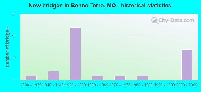
- New bridges - historical statistics
- 11930-1939
- 21940-1949
- 121950-1959
- 11960-1969
- 11970-1979
- 11980-1989
- 72000-2009
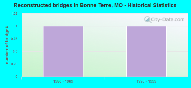
- Reconstructed bridges - Historical Statistics
- 11980-1989
- 11990-1999

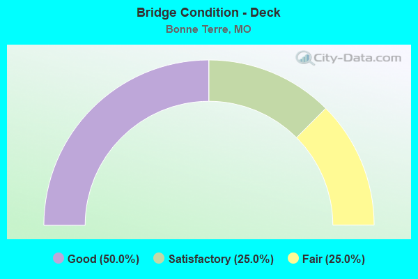
- Bridge Condition - Deck
- 50.0%Good
- 25.0%Satisfactory
- 25.0%Fair
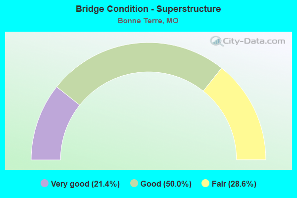
- Bridge Condition - Superstructure
- 21.4%Very good
- 50.0%Good
- 28.6%Fair
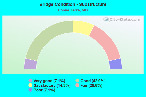
- Bridge Condition - Substructure
- 7.1%Very good
- 42.9%Good
- 14.3%Satisfactory
- 28.6%Fair
- 7.1%Poor
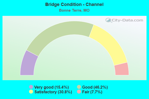
- Bridge Condition - Channel
- 15.4%Very good
- 46.2%Good
- 30.8%Satisfactory
- 7.7%Fair
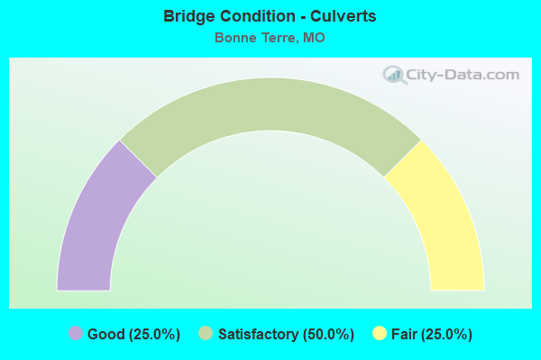
- Bridge Condition - Culverts
- 25.0%Good
- 50.0%Satisfactory
- 25.0%Fair
Find on map >> Show street view
Structure Number: 12069, Location: S 10 T 37 N R 5 E (Lat: 37.929639, Lng: -90.461419), Route carried "on" structure: State highway K, Year Built: 2001, Status: Open, Structure Length: 1.46m (4.79ft), Average Daily Traffic: 1,423 (year 2021), Truck Traffic: 11%, Average Future Daily Traffic: 2,277 (year 2041), Design Load: HS 20, Features Intersected: DRY BR
Minimum Vertical Clearance: 30+ m (98+ ft), Kilometerpoint: 7.216, Lanes on structure: 2, Owner: State Highway Agency, Approaching Roadway Width: 8.5m (27.9ft), Skew: 2 degrees, Material/Design: Concrete continuous, Design/Construction: Culvert, Number Of Spans In Main Unit: 3, Length of Maximum Span: 4.3m (14.1ft)
Condition: Channel: Good, Culverts: Good, Structural Evaluation: Better than present minimum criteria, Waterway Adequacy: Superior to present desirable criteria, Approach Roadway Alignment: Equal to present desirable criteria, Designated Inspection Frequency: Every 24 months, Inspection Date: March 2021
Find on map >> Show street view
Structure Number: 12234, Location: S 27 T 38 N R 4 E (Lat: 37.981239, Lng: -90.581800), Route carried "on" structure: County highway 3, Year Built: 1950, Status: Open, Structure Length: 0.91m (2.99ft), Average Daily Traffic: 15 (year 2021), Truck Traffic: 10%, Average Future Daily Traffic: 23 (year 2041), Features Intersected: PETER CR, Facility Carried by Structure: CROSSMAN RD
Minimum Vertical Clearance: 30+ m (98+ ft), Kilometerpoint: 1.448, Lanes on structure: 1, Owner: County Highway Agency, Approaching Roadway Width: 4.3m (14.1ft), Skew: 1 degrees, Material/Design: Steel continuous, Design/Construction: Stringer/Multi-beam, Number Of Spans In Main Unit: 2, Length of Maximum Span: 4.3m (14.1ft), Curb-To-Curb Width: 3.8m (12.5ft), Out-to-Out Width: 4.2m (13.8ft)
Condition: Deck: Satisfactory, Superstructure: Fair, Substructure: Good, Channel: Good, Operating Rating: 30.6 metric tons, Method Used To Determine Operating Rating: Load Factor (LF), Inventory Rating: 18.0 metric tons, Method Used To Determine Inventory Rating: Load Factor (LF), Structural Evaluation: Somewhat better than minimum adequacy, Deck Geometry: Meets minimum limits, Waterway Adequacy: Equal to present minimum criteria, Approach Roadway Alignment: Somewhat better than minimum adequacy, Designated Inspection Frequency: Every 24 months, Inspection Date: December 2020, Deck Structure Type: Concrete Cast-file-Place, Wearing Surface/Protective System: Wearing Surface: Bituminous
Find on map >> Show street view
Structure Number: 13143, Location: S 4 T 37 N R 4 E (Lat: 37.943728, Lng: -90.586264), Route carried "on" structure: County highway 30, Year Built: 1950, Status: Open, Structure Length: 1.71m (5.61ft), Average Daily Traffic: 250 (year 2021), Truck Traffic: 10%, Average Future Daily Traffic: 375 (year 2041), Features Intersected: CABANNA COURSE CR, Facility Carried by Structure: OLD CADET RD
Minimum Vertical Clearance: 30+ m (98+ ft), Kilometerpoint: 0.322, Lanes on structure: 2, Owner: County Highway Agency, Approaching Roadway Width: 5.5m (18.0ft), Material/Design: Concrete, Design/Construction: Slab, Number Of Spans In Main Unit: 4, Length of Maximum Span: 4.3m (14.1ft), Curb-To-Curb Width: 6.1m (20.0ft), Out-to-Out Width: 6.6m (21.7ft)
Condition: Deck: Good, Superstructure: Good, Substructure: Poor, Channel: Very good, Operating Rating: 49.5 metric tons, Method Used To Determine Operating Rating: Allowable Stress (AS), Inventory Rating: 16.2 metric tons, Method Used To Determine Inventory Rating: Allowable Stress (AS), Structural Evaluation: Meets minimum limits, Deck Geometry: Meets minimum limits, Waterway Adequacy: Somewhat better than minimum adequacy, Approach Roadway Alignment: Somewhat better than minimum adequacy, Length Of Structure Improvement: 0.24m (0.79ft), Designated Inspection Frequency: Every 24 months, Inspection Date: December 2020, Bridge Improvement Cost: $175,000, Roadway Improvement Cost: $18,000, Total Project Cost: $263,000 ( Estimate for 2022), Deck Structure Type: Concrete Cast-file-Place, Wearing Surface/Protective System: Wearing Surface: Bituminous
Find on map >> Show street view
Structure Number: 13146, Location: S 10 T 37 N R 4 E (Lat: 37.940881, Lng: -90.582986), Route carried "on" structure: County highway 30, Year Built: 1950, Status: Open, Structure Length: 0.70m (2.30ft), Average Daily Traffic: 250 (year 2021), Truck Traffic: 10%, Average Future Daily Traffic: 375 (year 2041), Features Intersected: CABANNA COURSE CR, Facility Carried by Structure: OLD CADET RD
Minimum Vertical Clearance: 30+ m (98+ ft), Kilometerpoint: 0.644, Lanes on structure: 2, Owner: County Highway Agency, Approaching Roadway Width: 6.7m (22.0ft), Skew: 5 degrees, Material/Design: Concrete, Design/Construction: Slab, Number Of Spans In Main Unit: 1, Length of Maximum Span: 6.7m (22.0ft), Curb-To-Curb Width: 6.1m (20.0ft), Out-to-Out Width: 6.6m (21.7ft)
Condition: Deck: Good, Superstructure: Good, Substructure: Satisfactory, Channel: Good, Operating Rating: 49.5 metric tons, Method Used To Determine Operating Rating: Allowable Stress (AS), Inventory Rating: 16.2 metric tons, Method Used To Determine Inventory Rating: Allowable Stress (AS), Structural Evaluation: Somewhat better than minimum adequacy, Deck Geometry: Meets minimum limits, Waterway Adequacy: Somewhat better than minimum adequacy, Approach Roadway Alignment: Somewhat better than minimum adequacy, Designated Inspection Frequency: Every 24 months, Inspection Date: December 2020, Deck Structure Type: Concrete Cast-file-Place, Wearing Surface/Protective System: Wearing Surface: Bituminous
Find on map >> Show street view
Structure Number: 13394, Location: S 2114 T 37 N R 5 E (Lat: 37.947281, Lng: -90.499128), Route carried "on" structure: County highway 37, Year Built: 1940, Year Reconstructed: 1992, Status: Open, Structure Length: 2.65m (8.69ft), Average Daily Traffic: 35 (year 2021), Truck Traffic: 10%, Average Future Daily Traffic: 53 (year 2041), Features Intersected: TERRE BLUE, Facility Carried by Structure: SAFFELL RD
Minimum Vertical Clearance: 30+ m (98+ ft), Kilometerpoint: 2.253, Lanes on structure: 2, Owner: County Highway Agency, Approaching Roadway Width: 6.1m (20.0ft), Material/Design: Concrete, Design/Construction: Slab, Number Of Spans In Main Unit: 6, Length of Maximum Span: 4.6m (15.1ft), Curb-To-Curb Width: 6.1m (20.0ft), Out-to-Out Width: 6.1m (20.0ft)
Condition: Deck: Good, Superstructure: Good, Substructure: Fair, Channel: Good, Operating Rating: 31.5 metric tons, Method Used To Determine Operating Rating: Allowable Stress (AS), Inventory Rating: 25.2 metric tons, Method Used To Determine Inventory Rating: Allowable Stress (AS), Structural Evaluation: Somewhat better than minimum adequacy, Deck Geometry: Somewhat better than minimum adequacy, Waterway Adequacy: Meets minimum limits, Approach Roadway Alignment: Equal to present minimum criteria, Designated Inspection Frequency: Every 24 months, Inspection Date: December 2020, Deck Structure Type: Concrete Cast-file-Place
Find on map >> Show street view
Structure Number: 13972, Location: S 2107 T 37 N R 5 E (Lat: 37.927481, Lng: -90.472006), Route carried "on" structure: County highway 53, Year Built: 1935, Status: Posted for load, Structure Length: 6.19m (20.31ft), Average Daily Traffic: 130 (year 2021), Truck Traffic: 10%, Average Future Daily Traffic: 195 (year 2041), Features Intersected: TERRE BLEUE, Facility Carried by Structure: HILLSBORO RD
Minimum Vertical Clearance: 30+ m (98+ ft), Kilometerpoint: 0.322, Lanes on structure: 2, Owner: County Highway Agency, Approaching Roadway Width: 7.3m (24.0ft), Material/Design: Masonry, Number Of Spans In Main Unit: 9, Length of Maximum Span: 9.1m (29.9ft), Curb-To-Curb Width: 6.1m (20.0ft), Out-to-Out Width: 6.8m (22.3ft)
Condition: Deck: Fair, Superstructure: Fair, Substructure: Fair, Channel: Fair, Operating Rating: 28.8 metric tons, Method Used To Determine Operating Rating: Allowable Stress (AS), Inventory Rating: 16.2 metric tons, Method Used To Determine Inventory Rating: Allowable Stress (AS), Structural Evaluation: Somewhat better than minimum adequacy, Deck Geometry: Meets minimum limits, Waterway Adequacy: Better than present minimum criteria, Approach Roadway Alignment: Equal to present desirable criteria, Designated Inspection Frequency: Every 24 months, Inspection Date: December 2020, Deck Structure Type: Concrete Cast-file-Place, Wearing Surface/Protective System: Wearing Surface: Bituminous
Find on map >> Show street view
Structure Number: 20664, Location: S 85 T 37 N R 5 E (Lat: 37.902939, Lng: -90.514964), Route carried "on" structure: County highway 269, Year Built: 1945, Status: Open, Structure Length: 1.13m (3.71ft), Average Daily Traffic: 1,500 (year 2021), Truck Traffic: 10%, Average Future Daily Traffic: 2,250 (year 2041), Features Intersected: BR OF BIG RVR, Facility Carried by Structure: VO-TECH RD
Minimum Vertical Clearance: 30+ m (98+ ft), Kilometerpoint: 2.575, Lanes on structure: 2, Owner: County Highway Agency, Approaching Roadway Width: 9.1m (29.9ft), Skew: 3 degrees, Material/Design: Concrete, Design/Construction: Culvert, Number Of Spans In Main Unit: 2, Length of Maximum Span: 5.2m (17.1ft), Curb-To-Curb Width: 9.1m (29.9ft), Out-to-Out Width: 9.8m (32.2ft)
Condition: Channel: Good, Culverts: Fair, Operating Rating: 49.5 metric tons, Method Used To Determine Operating Rating: Allowable Stress (AS), Inventory Rating: 16.2 metric tons, Method Used To Determine Inventory Rating: Allowable Stress (AS), Structural Evaluation: Meets minimum limits, Deck Geometry: Somewhat better than minimum adequacy, Waterway Adequacy: Equal to present desirable criteria, Approach Roadway Alignment: Better than present minimum criteria, Designated Inspection Frequency: Every 24 months, Inspection Date: December 2020
Find on map >> Show street view
Structure Number: 2997, Location: S 9 T 37 N R 4 E (Lat: 37.934192, Lng: -90.584572), Route carried "on" structure: State highway 47, Year Built: 1976, Status: Open, Structure Length: 1.18m (3.87ft), Average Daily Traffic: 3,012 (year 2021), Truck Traffic: 6%, Average Future Daily Traffic: 4,819 (year 2041), Design Load: HS 20, Features Intersected: CABANNE CR
Minimum Vertical Clearance: 30+ m (98+ ft), Kilometerpoint: 187.011, Lanes on structure: 2, Owner: State Highway Agency, Approaching Roadway Width: 6.1m (20.0ft), Skew: 1 degrees, Material/Design: Concrete continuous, Design/Construction: Culvert, Number Of Spans In Main Unit: 3, Length of Maximum Span: 3.7m (12.1ft)
Condition: Channel: Very good, Culverts: Satisfactory, Operating Rating: 87.3 metric tons, Method Used To Determine Operating Rating: Field evaluation and documented engineering judgment, Inventory Rating: 52.2 metric tons, Method Used To Determine Inventory Rating: Field evaluation and documented engineering judgment, Structural Evaluation: Equal to present minimum criteria, Waterway Adequacy: Equal to present desirable criteria, Approach Roadway Alignment: Equal to present desirable criteria, Designated Inspection Frequency: Every 24 months, Inspection Date: March 2021
Find on map >> Show street view
Structure Number: 31458, Location: S 23 T 37 N R 4 E (Lat: 37.906106, Lng: -90.549772), Route carried "on" structure: County highway , Year Built: 2006, Status: Open, Structure Length: 2.29m (7.51ft), Average Daily Traffic: 1,200 (year 2021), Truck Traffic: 10%, Average Future Daily Traffic: 1,800 (year 2041), Design Load: HS 20, Features Intersected: UP RR, Facility Carried by Structure: OLD BONNE TERRE RD
Minimum Vertical Clearance: 30+ m (98+ ft), Kilometerpoint: 0.000, Lanes on structure: 2, Owner: County Highway Agency, Approaching Roadway Width: 6.1m (20.0ft), Material/Design: Prestressed concrete, Design/Construction: Box Beam or Girders - Single/Spread, Number Of Spans In Main Unit: 1, Length of Maximum Span: 21.3m (69.9ft), Curb-To-Curb Width: 8.2m (26.9ft), Out-to-Out Width: 9.1m (29.9ft)
Condition: Deck: Good, Superstructure: Very good, Substructure: Very good, Operating Rating: 65.7 metric tons, Method Used To Determine Operating Rating: Load Factor (LF), Inventory Rating: 39.6 metric tons, Method Used To Determine Inventory Rating: Load Factor (LF), Structural Evaluation: Equal to present desirable criteria, Deck Geometry: Meets minimum limits, Approach Roadway Alignment: Equal to present desirable criteria, Designated Inspection Frequency: Every 24 months, Inspection Date: December 2020, Deck Structure Type: Concrete Cast-file-Place, Wearing Surface/Protective System: Wearing Surface: Monolithic Concrete
Find on map >> Show street view
Structure Number: 32275, Location: S 13 T 37 N R 4 E (Lat: 37.912047, Lng: -90.530794), Route carried "on" structure: US 67, Year Built: 2008, Status: Open, Structure Length: 1.92m (6.30ft), Average Daily Traffic: 13,486 (year 2021), Truck Traffic: 10%, Average Future Daily Traffic: 23,601 (year 2041), Features Intersected: CST OLD ORCHARD RD
Minimum Vertical Clearance: 30+ m (98+ ft), Kilometerpoint: 137.858, Lanes on structure: 2, Lanes under structure: 2, Base Highway Network: Yes, Owner: State Highway Agency, Approaching Roadway Width: 14.8m (48.6ft), Material/Design: Concrete, Design/Construction: Arch - Deck, Number Of Spans In Main Unit: 1, Length of Maximum Span: 18.3m (60.0ft), Curb-To-Curb Width: 14.8m (48.6ft), Out-to-Out Width: 18.0m (59.1ft)
Condition: Superstructure: Very good, Substructure: Good, Operating Rating: 51.3 metric tons, Method Used To Determine Operating Rating: Load Factor (LF), Inventory Rating: 41.4 metric tons, Method Used To Determine Inventory Rating: Load Factor (LF), Structural Evaluation: Better than present minimum criteria, Deck Geometry: Superior to present desirable criteria, Underclear: Somewhat better than minimum adequacy, Approach Roadway Alignment: Equal to present desirable criteria, Designated Inspection Frequency: Every 24 months, Inspection Date: October 2020
Find on map >> Show street view
Structure Number: 32278, Location: S 13 T 37 N R 4 E (Lat: 37.912228, Lng: -90.530742), Route carried "on" structure: US 67, Year Built: 2008, Status: Open, Structure Length: 1.92m (6.30ft), Average Daily Traffic: 13,455 (year 2021), Truck Traffic: 9%, Average Future Daily Traffic: 23,546 (year 2041), Features Intersected: CST OLD ORCHARD RD
Minimum Vertical Clearance: 30+ m (98+ ft), Kilometerpoint: 180.287, Lanes on structure: 2, Lanes under structure: 2, Base Highway Network: Yes, Owner: State Highway Agency, Approaching Roadway Width: 11.8m (38.7ft), Material/Design: Concrete, Design/Construction: Arch - Deck, Number Of Spans In Main Unit: 1, Length of Maximum Span: 18.3m (60.0ft), Curb-To-Curb Width: 11.8m (38.7ft), Out-to-Out Width: 13.5m (44.3ft)
Condition: Superstructure: Very good, Substructure: Good, Operating Rating: 51.3 metric tons, Method Used To Determine Operating Rating: Load Factor (LF), Inventory Rating: 41.4 metric tons, Method Used To Determine Inventory Rating: Load Factor (LF), Structural Evaluation: Better than present minimum criteria, Deck Geometry: Equal to present minimum criteria, Underclear: Somewhat better than minimum adequacy, Approach Roadway Alignment: Equal to present desirable criteria, Designated Inspection Frequency: Every 24 months, Inspection Date: October 2020
Find on map >> Show street view
Structure Number: 32735, Location: S 5 T 37 N R 5 E (Lat: 37.951078, Lng: -90.488794), Route carried "on" structure: County highway 37, Year Built: 2008, Status: Open, Structure Length: 1.23m (4.04ft), Average Daily Traffic: 35 (year 2021), Truck Traffic: 10%, Average Future Daily Traffic: 53 (year 2041), Features Intersected: BR TERRE BLEUE CR, Facility Carried by Structure: SAFFELL RD
Minimum Vertical Clearance: 30+ m (98+ ft), Kilometerpoint: 0.000, Lanes on structure: 2, Owner: County Highway Agency, Approaching Roadway Width: 7.6m (24.9ft), Material/Design: Steel, Design/Construction: Stringer/Multi-beam, Number Of Spans In Main Unit: 2, Length of Maximum Span: 5.8m (19.0ft), Curb-To-Curb Width: 7.3m (24.0ft), Out-to-Out Width: 7.6m (24.9ft)
Condition: Deck: Good, Superstructure: Good, Substructure: Good, Channel: Good, Operating Rating: 47.7 metric tons, Method Used To Determine Operating Rating: Load Factor (LF), Inventory Rating: 28.8 metric tons, Method Used To Determine Inventory Rating: Load Factor (LF), Structural Evaluation: Better than present minimum criteria, Deck Geometry: Equal to present minimum criteria, Waterway Adequacy: Superior to present desirable criteria, Approach Roadway Alignment: Equal to present desirable criteria, Designated Inspection Frequency: Every 24 months, Inspection Date: December 2020, Deck Structure Type: Concrete Cast-file-Place, Wearing Surface/Protective System: Wearing Surface: Monolithic Concrete
Find on map >> Show street view
Structure Number: 3373, Location: S 34 T 38 N R 4 E (Lat: 37.965500, Lng: -90.574342), Route carried "on" structure: State highway E, Year Built: 1983, Status: Open, Structure Length: 16.34m (53.61ft), Average Daily Traffic: 2,476 (year 2021), Truck Traffic: 9%, Average Future Daily Traffic: 3,962 (year 2041), Design Load: H 15, Features Intersected: BIG RVR
Minimum Vertical Clearance: 30+ m (98+ ft), Kilometerpoint: 20.205, Lanes on structure: 2, Owner: State Highway Agency, Approaching Roadway Width: 6.7m (22.0ft), Skew: 3 degrees, Material/Design: Prestressed concrete continuous, Design/Construction: Stringer/Multi-beam, Number Of Spans In Main Unit: 9, Length of Maximum Span: 27.4m (89.9ft), Curb or Sidewalk Widths: Left: 0.2m (0.7ft), Right: 0.2m (0.7ft), Curb-To-Curb Width: 10.0m (32.8ft), Out-to-Out Width: 10.8m (35.4ft)
Condition: Deck: Good, Superstructure: Fair, Substructure: Satisfactory, Channel: Satisfactory, Operating Rating: 55.8 metric tons, Method Used To Determine Operating Rating: Load Factor (LF), Inventory Rating: 22.5 metric tons, Method Used To Determine Inventory Rating: Load Factor (LF), Structural Evaluation: Somewhat better than minimum adequacy, Deck Geometry: Meets minimum limits, Waterway Adequacy: Equal to present desirable criteria, Approach Roadway Alignment: Equal to present desirable criteria, Designated Inspection Frequency: Every 24 months, Inspection Date: October 2020, Deck Structure Type: Concrete Cast-file-Place, Wearing Surface/Protective System: Wearing Surface: Bituminous, Deck Protection: Epoxy Coated Reinforcing
Find on map >> Show street view
Structure Number: 471, Location: S 467 T 37 N R 4 E (Lat: 37.921956, Lng: -90.538267), Route carried "on" structure: US 67, Year Built: 1959, Status: Open, Structure Length: 5.18m (16.99ft), Average Daily Traffic: 13,455 (year 2021), Truck Traffic: 9%, Average Future Daily Traffic: 23,546 (year 2041), Design Load: H 20, Features Intersected: MO 47
Minimum Vertical Clearance: 30+ m (98+ ft), Kilometerpoint: 181.633, Lanes on structure: 2, Lanes under structure: 4, Base Highway Network: Yes, Owner: State Highway Agency, Approaching Roadway Width: 7.3m (24.0ft), Skew: 1 degrees, Material/Design: Steel continuous, Design/Construction: Stringer/Multi-beam, Number Of Spans In Main Unit: 3, Length of Maximum Span: 21.3m (69.9ft), Curb-To-Curb Width: 9.4m (30.8ft), Out-to-Out Width: 10.1m (33.1ft)
Condition: Deck: Satisfactory, Superstructure: Good, Substructure: Good, Operating Rating: 39.6 metric tons, Method Used To Determine Operating Rating: Load Factor (LF), Inventory Rating: 24.3 metric tons, Method Used To Determine Inventory Rating: Load Factor (LF), Structural Evaluation: Equal to present minimum criteria, Deck Geometry: High priority of replacement, Underclear: Somewhat better than minimum adequacy, Approach Roadway Alignment: Equal to present desirable criteria, Length Of Structure Improvement: 0.62m (2.03ft), Designated Inspection Frequency: Every 24 months, Inspection Date: October 2020, Bridge Improvement Cost: $505,000, Roadway Improvement Cost: $51,000, Total Project Cost: $758,000 ( Estimate for 2022), Deck Structure Type: Concrete Cast-file-Place, Wearing Surface/Protective System: Wearing Surface: Latex Concrete, Membrane: Built-up, Deck Protection: Internally Sealed
Find on map >> Show street view
Structure Number: 6402, Location: S 2 T 37 N R 4 E (Lat: 37.955017, Lng: -90.551533), Route carried "on" structure: US 67, Year Built: 1956, Year Reconstructed: 2002, Status: Open, Structure Length: 14.39m (47.21ft), Average Daily Traffic: 10,921 (year 2021), Truck Traffic: 9%, Average Future Daily Traffic: 19,112 (year 2041), Design Load: H 20, Features Intersected: BIG RIVER, DECLUE LN
Minimum Vertical Clearance: 30+ m (98+ ft), Kilometerpoint: 185.508, Lanes on structure: 2, Lanes under structure: 1, Base Highway Network: Yes, Owner: State Highway Agency, Approaching Roadway Width: 10.3m (33.8ft), Skew: 1 degrees, Material/Design: Steel continuous, Design/Construction: Stringer/Multi-beam, Number Of Spans In Main Unit: 3, Number Of Approach Spans: 5, Length of Maximum Span: 27.4m (89.9ft), Curb-To-Curb Width: 8.5m (27.9ft), Out-to-Out Width: 9.7m (31.8ft)
Condition: Deck: Satisfactory, Superstructure: Fair, Substructure: Fair, Channel: Satisfactory, Operating Rating: 38.7 metric tons, Method Used To Determine Operating Rating: Load Factor (LF), Inventory Rating: 23.4 metric tons, Method Used To Determine Inventory Rating: Load Factor (LF), Structural Evaluation: Somewhat better than minimum adequacy, Deck Geometry: High priority of corrective action, Waterway Adequacy: Equal to present desirable criteria, Approach Roadway Alignment: Equal to present desirable criteria, Length Of Structure Improvement: 1.52m (4.99ft), Designated Inspection Frequency: Every 24 months, Inspection Date: January 2022, Bridge Improvement Cost: $1,242,000, Roadway Improvement Cost: $124,000, Total Project Cost: $1,863,000 ( Estimate for 2022), Deck Structure Type: Concrete Cast-file-Place, Wearing Surface/Protective System: Wearing Surface: Monolithic Concrete, Deck Protection: Epoxy Coated Reinforcing
Find on map >> Show street view
Structure Number: 6403, Location: S 83 T 37 N R 5 E (Lat: 37.902219, Lng: -90.513478), Route carried "on" structure: US 67, Year Built: 1957, Status: Open, Structure Length: 0.84m (2.76ft), Average Daily Traffic: 26,941 (year 2021), Truck Traffic: 10%, Average Future Daily Traffic: 47,147 (year 2041), Design Load: H 20, Features Intersected: DAYCE CR
Minimum Vertical Clearance: 30+ m (98+ ft), Kilometerpoint: 139.670, Lanes on structure: 4, Base Highway Network: Yes, Owner: State Highway Agency, Approaching Roadway Width: 32.9m (107.9ft), Skew: 2 degrees, Material/Design: Concrete continuous, Design/Construction: Culvert, Number Of Spans In Main Unit: 2, Length of Maximum Span: 3.7m (12.1ft)
Condition: Channel: Satisfactory, Culverts: Satisfactory, Operating Rating: 72.0 metric tons, Method Used To Determine Operating Rating: Field evaluation and documented engineering judgment, Inventory Rating: 43.2 metric tons, Method Used To Determine Inventory Rating: Field evaluation and documented engineering judgment, Structural Evaluation: Equal to present minimum criteria, Waterway Adequacy: Equal to present desirable criteria, Approach Roadway Alignment: Equal to present desirable criteria, Designated Inspection Frequency: Every 24 months, Inspection Date: March 2021
Find on map >> Show street view
Structure Number: 717, Location: S 72 T 37 N R 5 E (Lat: 37.926664, Lng: -90.502003), Route carried "on" structure: State highway K, Year Built: 1964, Status: Open, Structure Length: 12.83m (42.09ft), Average Daily Traffic: 6,737 (year 2021), Truck Traffic: 11%, Average Future Daily Traffic: 10,779 (year 2041), Design Load: H 15, Features Intersected: BIG RIVER
Minimum Vertical Clearance: 30+ m (98+ ft), Kilometerpoint: 3.484, Lanes on structure: 2, Owner: State Highway Agency, Approaching Roadway Width: 6.7m (22.0ft), Skew: 2 degrees, Material/Design: Steel continuous, Design/Construction: Stringer/Multi-beam, Number Of Spans In Main Unit: 3, Length of Maximum Span: 50.2m (164.7ft), Curb-To-Curb Width: 7.9m (25.9ft), Out-to-Out Width: 9.0m (29.5ft)
Condition: Deck: Fair, Superstructure: Good, Substructure: Fair, Channel: Satisfactory, Operating Rating: 32.4 metric tons, Method Used To Determine Operating Rating: Load Factor (LF), Inventory Rating: 19.8 metric tons, Method Used To Determine Inventory Rating: Load Factor (LF), Structural Evaluation: Somewhat better than minimum adequacy, Deck Geometry: High priority of corrective action, Waterway Adequacy: Equal to present desirable criteria, Approach Roadway Alignment: Equal to present desirable criteria, Length Of Structure Improvement: 1.37m (4.49ft), Designated Inspection Frequency: Every 24 months, Inspection Date: January 2022, Bridge Improvement Cost: $2,203,000, Roadway Improvement Cost: $220,000, Total Project Cost: $3,304,000 ( Estimate for 2022), Deck Structure Type: Concrete Cast-file-Place, Wearing Surface/Protective System: Wearing Surface: Bituminous
Find on map >> Show street view
Structure Number: 784, Location: S 467 T 37 N R 4 E (Lat: 37.922003, Lng: -90.538503), Route carried "on" structure: US 67, Year Built: 1959, Status: Open, Structure Length: 5.18m (16.99ft), Average Daily Traffic: 10,660 (year 2021), Truck Traffic: 10%, Average Future Daily Traffic: 18,655 (year 2041), Design Load: H 20, Features Intersected: MO 47
Minimum Vertical Clearance: 30+ m (98+ ft), Kilometerpoint: 136.426, Lanes on structure: 2, Lanes under structure: 4, Base Highway Network: Yes, Owner: State Highway Agency, Approaching Roadway Width: 7.3m (24.0ft), Skew: 1 degrees, Material/Design: Steel continuous, Design/Construction: Stringer/Multi-beam, Number Of Spans In Main Unit: 3, Length of Maximum Span: 21.3m (69.9ft), Curb-To-Curb Width: 9.4m (30.8ft), Out-to-Out Width: 10.1m (33.1ft)
Condition: Deck: Fair, Superstructure: Good, Substructure: Good, Operating Rating: 38.7 metric tons, Method Used To Determine Operating Rating: Load Factor (LF), Inventory Rating: 23.4 metric tons, Method Used To Determine Inventory Rating: Load Factor (LF), Structural Evaluation: Somewhat better than minimum adequacy, Deck Geometry: High priority of replacement, Underclear: Somewhat better than minimum adequacy, Approach Roadway Alignment: Equal to present desirable criteria, Length Of Structure Improvement: 0.62m (2.03ft), Designated Inspection Frequency: Every 24 months, Inspection Date: October 2020, Bridge Improvement Cost: $505,000, Roadway Improvement Cost: $51,000, Total Project Cost: $758,000 ( Estimate for 2022), Deck Structure Type: Concrete Cast-file-Place, Wearing Surface/Protective System: Wearing Surface: Bituminous, Membrane: Built-up
Find on map >> Show street view
Structure Number: 32275, Location: S 13 T 37 N R 4 E (Lat: 37.912047, Lng: -90.530794), Route carried "under" structure: City street , Year Built: 2008, Structure Length: 0. m, Average Daily Traffic: 4,662 (year 2021), Truck Traffic: 5%, Features Intersected: CST OLD ORCHARD RD, Facility Carried by Structure: US 67 S
Minimum Vertical Clearance: 5.03m (16.50ft), Kilometerpoint: 1.014, Lanes on structure: 2, Lanes under structure: 2, Material/Design: Concrete, Design/Construction: Arch - Deck, Length of Maximum Span: 18.3m (60.0ft)
Find on map >> Show street view
Structure Number: 32278, Location: S 13 T 37 N R 4 E (Lat: 37.912228, Lng: -90.530742), Route carried "under" structure: City street , Year Built: 2008, Structure Length: 0. m, Average Daily Traffic: 4,662 (year 2021), Truck Traffic: 5%, Features Intersected: CST OLD ORCHARD RD, Facility Carried by Structure: US 67 N
Minimum Vertical Clearance: 5.03m (16.50ft), Kilometerpoint: 0.995, Lanes on structure: 2, Lanes under structure: 2, Material/Design: Concrete, Design/Construction: Arch - Deck, Length of Maximum Span: 18.3m (60.0ft)
Find on map >> Show street view
Structure Number: 471, Location: S 467 T 37 N R 4 E (Lat: 37.921956, Lng: -90.538267), Route carried "under" structure: State highway 47, Year Built: 1959, Structure Length: 0. m, Average Daily Traffic: 13,845 (year 2021), Truck Traffic: 3%, Features Intersected: MO 47, Facility Carried by Structure: US 67 N
Minimum Vertical Clearance: 4.62m (15.16ft), Kilometerpoint: 191.747, Lanes on structure: 2, Lanes under structure: 4, Material/Design: Steel continuous, Design/Construction: Stringer/Multi-beam, Length of Maximum Span: 21.3m (69.9ft)
Find on map >> Show street view
Structure Number: 472, Location: S 29 T 37 N R 5 E (Lat: 37.880850, Lng: -90.509408), Route carried "under" structure: State highway 8, Year Built: 1959, Structure Length: 0. m, Average Daily Traffic: 14,186 (year 2021), Truck Traffic: 7%, Features Intersected: MO 8, Facility Carried by Structure: US 67 N
Minimum Vertical Clearance: 4.72m (15.49ft), Kilometerpoint: 115.933, Lanes on structure: 2, Lanes under structure: 2, Material/Design: Steel, Design/Construction: Stringer/Multi-beam, Length of Maximum Span: 20.7m (67.9ft)
Find on map >> Show street view
Structure Number: 6402, Location: S 2 T 37 N R 4 E (Lat: 37.955017, Lng: -90.551533), Route carried "under" structure: County highway , Year Built: 1956, Structure Length: 0. m, Average Daily Traffic: 20 (year 2018), Truck Traffic: 5%, Features Intersected: DECLUE LN, Facility Carried by Structure: US 67 N
Minimum Vertical Clearance: 30+ m (98+ ft), Kilometerpoint: 0.000, Lanes on structure: 2, Lanes under structure: 1, Material/Design: Steel continuous, Design/Construction: Stringer/Multi-beam, Length of Maximum Span: 27.4m (89.9ft)
Find on map >> Show street view
Structure Number: 784, Location: S 467 T 37 N R 4 E (Lat: 37.922003, Lng: -90.538503), Route carried "under" structure: State highway 47, Year Built: 1959, Structure Length: 0. m, Average Daily Traffic: 13,845 (year 2021), Truck Traffic: 3%, Features Intersected: MO 47, Facility Carried by Structure: US 67 S
Minimum Vertical Clearance: 4.62m (15.16ft), Kilometerpoint: 191.726, Lanes on structure: 2, Lanes under structure: 4, Material/Design: Steel continuous, Design/Construction: Stringer/Multi-beam, Length of Maximum Span: 21.3m (69.9ft)
Find on map >> Show street view
Structure Number: 785, Location: S 29 T 37 N R 5 E (Lat: 37.880947, Lng: -90.509631), Route carried "under" structure: State highway 8, Year Built: 1959, Structure Length: 0. m, Average Daily Traffic: 14,186 (year 2021), Truck Traffic: 7%, Features Intersected: MO 8, Facility Carried by Structure: US 67 S
Minimum Vertical Clearance: 4.62m (15.16ft), Kilometerpoint: 115.913, Lanes on structure: 2, Lanes under structure: 2, Material/Design: Steel, Design/Construction: Stringer/Multi-beam, Length of Maximum Span: 20.7m (67.9ft)