Bridge Statistics for Bloomfield Township, Michigan (MI)
Condition, Traffic, Stress, Structural Evaluation, Project Costs
- National Bridge Inventory (NBI) Statistics
- 18Number of bridges
- 151ft / 45.7mTotal length
- $277,000Total costs
- 419,373Total average daily traffic
- 21,393Total average daily truck traffic
- National Bridge Inventory (NBI) Registered Bridges for Bloomfield Township
- No street view available for this location
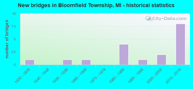
- New bridges - historical statistics
- 11930-1939
- 11950-1959
- 11960-1969
- 41980-1989
- 11990-1999
- 22000-2009
- 82010-2019


- Bridge Condition - Deck
- 55.6%Very good
- 22.2%Good
- 11.1%Satisfactory
- 11.1%Poor

- Bridge Condition - Superstructure
- 55.6%Very good
- 22.2%Good
- 11.1%Fair
- 11.1%Poor

- Bridge Condition - Substructure
- 55.6%Very good
- 11.1%Good
- 11.1%Satisfactory
- 22.2%Fair

- Bridge Condition - Channel
- 30.0%Very good
- 20.0%Good
- 30.0%Satisfactory
- 10.0%Fair
- 10.0%Poor

- Bridge Condition - Culverts
- 40.0%Good
- 60.0%Poor
Find on map >> Show street view
Structure Number: 1543, Location: SEC.13/24,T34N,R2W (Lat: 45.330472, Lng: -84.494997), Route carried "on" structure: County highway , Year Built: 1995, Status: Posted for load, Structure Length: 2.28m (7.48ft), Average Daily Traffic: 620 (year 2005), Average Future Daily Traffic: 1,100 (year 2025), Design Load: HS 20+Mod, Features Intersected: PIGEON RIVER, Facility Carried by Structure: PIGEON RIVER ROAD
Minimum Vertical Clearance: 30.48m (100.00ft), Kilometerpoint: 6.088, Lanes on structure: 2, Owner: County Highway Agency, Approaching Roadway Width: 7.3m (24.0ft), Material/Design: Prestressed concrete, Design/Construction: Box Beam or Girders - Multiple, Number Of Spans In Main Unit: 1, Length of Maximum Span: 21.6m (70.9ft), Curb-To-Curb Width: 9.8m (32.2ft), Out-to-Out Width: 10.4m (34.1ft)
Condition: Deck: Very good, Superstructure: Very good, Substructure: Very good, Channel: Good, Operating Rating: 51.5 metric tons, Method Used To Determine Operating Rating: Load Factor (LF) rating reported by rating factor (RF) method using MS18 loading, Inventory Rating: 13.6 metric tons, Method Used To Determine Inventory Rating: Load Factor (LF) rating reported by rating factor (RF) method using MS18 loading, Structural Evaluation: Meets minimum limits, Deck Geometry: Equal to present minimum criteria, Waterway Adequacy: Equal to present desirable criteria, Approach Roadway Alignment: Equal to present desirable criteria, Bridge Posting: Required (Relationship of Operating Rating to Maximum Legal Load: 0.1 - 9.9% below), Designated Inspection Frequency: Every 24 months, Inspection Date: July 2021, Deck Structure Type: Concrete Cast-file-Place, Wearing Surface/Protective System: Wearing Surface: Monolithic Concrete, Deck Protection: Epoxy Coated Reinforcing
Find on map >> Show street view
Structure Number: 1546, Location: SEC 29 T33NR1E (Lat: 45.224300, Lng: -84.331003), Route carried "on" structure: County highway , Year Built: 1987, Status: Open, Structure Length: 1.95m (6.40ft), Average Daily Traffic: 230 (year 2005), Average Future Daily Traffic: 410 (year 2025), Design Load: HS 20+Mod, Features Intersected: BLACK RIVER, Facility Carried by Structure: CLARK BRIDGE ROAD
Minimum Vertical Clearance: 30.48m (100.00ft), Kilometerpoint: 5.078, Lanes on structure: 2, Owner: County Highway Agency, Approaching Roadway Width: 9.1m (29.9ft), Material/Design: Prestressed concrete, Design/Construction: Box Beam or Girders - Multiple, Number Of Spans In Main Unit: 1, Length of Maximum Span: 19.5m (64.0ft), Curb-To-Curb Width: 9.4m (30.8ft), Out-to-Out Width: 9.4m (30.8ft)
Condition: Deck: Satisfactory, Superstructure: Good, Substructure: Good, Channel: Very good, Operating Rating: 51.8 metric tons, Method Used To Determine Operating Rating: Load and Resistance Factor Rating (LRFR) rating reported by rating factor(RF) method using HL-93 loadings, Inventory Rating: 39.9 metric tons, Method Used To Determine Inventory Rating: Load and Resistance Factor Rating (LRFR) rating reported by rating factor(RF) method using HL-93 loadings, Structural Evaluation: Better than present minimum criteria, Deck Geometry: Equal to present minimum criteria, Waterway Adequacy: Better than present minimum criteria, Approach Roadway Alignment: Better than present minimum criteria, Designated Inspection Frequency: Every 24 months, Inspection Date: July 2021, Deck Structure Type: Concrete Cast-file-Place, Wearing Surface/Protective System: Wearing Surface: Bituminous, Membrane: Preformed Fabric, Deck Protection: Epoxy Coated Reinforcing
Find on map >> Show street view
Structure Number: 5336, Location: SE OF LAPEER (Lat: 43.024417, Lng: -83.316242), Route carried "on" structure: Interstate 69, Year Built: 1983, Status: Open, Structure Length: 3.75m (12.30ft), Average Daily Traffic: 12,398 (year 2007), Truck Traffic: 18%, Average Future Daily Traffic: 14,061 (year 2018), Design Load: HS 25 or greater, Features Intersected: HUNTER CREEK
Minimum Vertical Clearance: 30.48m (100.00ft), Kilometerpoint: 12.050, Lanes on structure: 3, Base Highway Network: Yes (Inventory Route: 75, Subroute: 2), Owner: State Highway Agency, Approaching Roadway Width: 18.0m (59.1ft), Material/Design: Prestressed concrete, Design/Construction: Stringer/Multi-beam, Number Of Spans In Main Unit: 3, Length of Maximum Span: 12.5m (41.0ft), Curb-To-Curb Width: 16.1m (52.8ft), Out-to-Out Width: 17.3m (56.8ft)
Condition: Deck: Good, Superstructure: Fair, Substructure: Satisfactory, Channel: Good, Operating Rating: 73.9 metric tons, Method Used To Determine Operating Rating: Load Factor (LF) rating reported by rating factor (RF) method using MS18 loading, Inventory Rating: 44.1 metric tons, Method Used To Determine Inventory Rating: Load Factor (LF) rating reported by rating factor (RF) method using MS18 loading, Structural Evaluation: Somewhat better than minimum adequacy, Deck Geometry: Equal to present minimum criteria, Waterway Adequacy: Equal to present desirable criteria, Approach Roadway Alignment: Equal to present desirable criteria, Designated Inspection Frequency: Every 24 months, Inspection Date: May 2021, Deck Structure Type: Concrete Cast-file-Place, Wearing Surface/Protective System: Wearing Surface: Epoxy Overlay, Deck Protection: Epoxy Coated Reinforcing
Find on map >> Show street view
Structure Number: 5394, Location: SEC. 4 ALMONT TWP. (Lat: 42.976892, Lng: -83.064967), Route carried "on" structure: County highway , Year Built: 1980, Status: Open, Structure Length: 0.91m (2.99ft), Average Daily Traffic: 105 (year 2018), Truck Traffic: 3%, Average Future Daily Traffic: 128 (year 2038), Design Load: H 20, Features Intersected: WESTON DRAIN, Facility Carried by Structure: WEBSTER ROAD
Minimum Vertical Clearance: 30.48m (100.00ft), Kilometerpoint: 2.010, Lanes on structure: 2, Owner: County Highway Agency, Approaching Roadway Width: 7.3m (24.0ft), Material/Design: Steel, Design/Construction: Culvert, Number Of Spans In Main Unit: 3, Length of Maximum Span: 2.4m (7.9ft), Out-to-Out Width: 28.2m (92.5ft)
Condition: Channel: Fair, Culverts: Poor, Operating Rating: 49.9 metric tons, Method Used To Determine Operating Rating: Load Factor (LF) rating reported by rating factor (RF) method using MS18 loading, Inventory Rating: 29.8 metric tons, Method Used To Determine Inventory Rating: Load Factor (LF) rating reported by rating factor (RF) method using MS18 loading, Structural Evaluation: Meets minimum limits, Waterway Adequacy: Equal to present desirable criteria, Approach Roadway Alignment: Better than present minimum criteria, Designated Inspection Frequency: Every 12 months, Inspection Date: June 2021
Find on map >> Show street view
Structure Number: 8083, Location: 2.7 MI SE OF M-59 (Lat: 42.610317, Lng: -83.222997), Route carried "on" structure: County highway , Year Built: 2017, Status: Open, Structure Length: 7.19m (23.59ft), Average Daily Traffic: 3,700 (year 2005), Average Future Daily Traffic: 4,255 (year 2025), Design Load: Greater than HL93, Features Intersected: I-75, Facility Carried by Structure: SQUIRREL RD
Minimum Vertical Clearance: 30.48m (100.00ft), Kilometerpoint: 3.906, Lanes on structure: 2, Lanes under structure: 11, Owner: State Highway Agency, Approaching Roadway Width: 10.9m (35.8ft), Skew: 2 degrees, Material/Design: Prestressed concrete, Design/Construction: Stringer/Multi-beam, Number Of Spans In Main Unit: 2, Length of Maximum Span: 38.5m (126.3ft), Curb or Sidewalk Widths: Left: 1.8m (5.9ft), Right: 0.0m, Curb-To-Curb Width: 10.1m (33.1ft), Out-to-Out Width: 13.0m (42.7ft)
Condition: Deck: Very good, Superstructure: Very good, Substructure: Very good, Operating Rating: 56.7 metric tons, Method Used To Determine Operating Rating: Load and Resistance Factor Rating (LRFR) rating reported by rating factor(RF) method using HL-93 loadings, Inventory Rating: 43.7 metric tons, Method Used To Determine Inventory Rating: Load and Resistance Factor Rating (LRFR) rating reported by rating factor(RF) method using HL-93 loadings, Structural Evaluation: Equal to present desirable criteria, Deck Geometry: Meets minimum limits, Underclear: Somewhat better than minimum adequacy, Approach Roadway Alignment: Equal to present desirable criteria, Designated Inspection Frequency: Every 24 months, Inspection Date: December 2021, Deck Structure Type: Concrete Cast-file-Place, Wearing Surface/Protective System: Wearing Surface: Monolithic Concrete, Deck Protection: Epoxy Coated Reinforcing
Find on map >> Show street view
Structure Number: 8085, Location: 9.5 MI E OF PONTIAC (Lat: 42.613519, Lng: -83.232806), Route carried "on" structure: Ramp Interstate 75, Year Built: 2017, Status: Open, Structure Length: 14.30m (46.92ft), Average Daily Traffic: 24,209 (year 1999), Truck Traffic: 2%, Average Future Daily Traffic: 31,472 (year 2014), Design Load: Greater than HL93, Features Intersected: I-75 SB & I-75BL
Minimum Vertical Clearance: 30.48m (100.00ft), Kilometerpoint: 0.494, Lanes on structure: 2, Lanes under structure: 5, Owner: State Highway Agency, Approaching Roadway Width: 12.8m (42.0ft), Skew: 9 degrees, Material/Design: Prestressed concrete, Design/Construction: Stringer/Multi-beam, Number Of Spans In Main Unit: 4, Length of Maximum Span: 46.5m (152.6ft), Curb-To-Curb Width: 13.4m (44.0ft), Out-to-Out Width: 14.4m (47.2ft)
Condition: Deck: Very good, Superstructure: Very good, Substructure: Very good, Operating Rating: 52.8 metric tons, Method Used To Determine Operating Rating: Load and Resistance Factor Rating (LRFR) rating reported by rating factor(RF) method using HL-93 loadings, Inventory Rating: 34.7 metric tons, Method Used To Determine Inventory Rating: Load and Resistance Factor Rating (LRFR) rating reported by rating factor(RF) method using HL-93 loadings, Structural Evaluation: Equal to present desirable criteria, Deck Geometry: Superior to present desirable criteria, Underclear: Somewhat better than minimum adequacy, Approach Roadway Alignment: Equal to present desirable criteria, Designated Inspection Frequency: Every 24 months, Inspection Date: October 2021, Bridge Improvement Cost: $35,000, Roadway Improvement Cost: $4,000, Total Project Cost: $41,000, Deck Structure Type: Concrete Cast-file-Place, Wearing Surface/Protective System: Wearing Surface: Monolithic Concrete, Deck Protection: Epoxy Coated Reinforcing
Find on map >> Show street view
Structure Number: 8146, Location: NORTH OF FOURTEEN MILE (Lat: 42.529897, Lng: -83.305178), Route carried "on" structure: County highway , Year Built: 1959, Status: Open, Structure Length: 0.91m (2.99ft), Average Daily Traffic: 8,740 (year 1993), Truck Traffic: 5%, Average Future Daily Traffic: 10,500 (year 2017), Design Load: HS 20+Mod, Features Intersected: ROUGE RIVER, Facility Carried by Structure: FRANKLIN
Minimum Vertical Clearance: 30.48m (100.00ft), Kilometerpoint: 3.327, Lanes on structure: 2, Owner: County Highway Agency, Approaching Roadway Width: 7.3m (24.0ft), Material/Design: Steel, Design/Construction: Culvert, Number Of Spans In Main Unit: 2, Length of Maximum Span: 3.6m (11.8ft), Out-to-Out Width: 6.1m (20.0ft)
Condition: Channel: Satisfactory, Culverts: Poor, Operating Rating: 97.2 metric tons, Method Used To Determine Operating Rating: Load Factor (LF) rating reported by rating factor (RF) method using MS18 loading, Inventory Rating: 97.2 metric tons, Method Used To Determine Inventory Rating: Load Factor (LF) rating reported by rating factor (RF) method using MS18 loading, Structural Evaluation: Meets minimum limits, Waterway Adequacy: Equal to present desirable criteria, Approach Roadway Alignment: Equal to present minimum criteria, Length Of Structure Improvement: 0.91m (2.99ft), Designated Inspection Frequency: Every 12 months, Inspection Date: August 2021, Bridge Improvement Cost: $200,000, Roadway Improvement Cost: $20,000, Total Project Cost: $236,000 ( Estimate for 2050), Wearing Surface/Protective System: Wearing Surface: Bituminous
Find on map >> Show street view
Structure Number: 815, Location: BET WATTLES AND BIG BEAVE (Lat: 42.574197, Lng: -83.207072), Route carried "on" structure: County highway 2059, Year Built: 2004, Status: Open, Structure Length: 1.22m (4.00ft), Average Daily Traffic: 16,577 (year 1991), Truck Traffic: 5%, Average Future Daily Traffic: 22,000 (year 2010), Design Load: HS 20, Features Intersected: ROUGE RIVER, Facility Carried by Structure: ADAMS ROAD
Minimum Vertical Clearance: 30.48m (100.00ft), Kilometerpoint: 4.110, Lanes on structure: 2, Base Highway Network: Yes (Inventory Route: 441, Subroute: 61), Owner: County Highway Agency, Approaching Roadway Width: 12.2m (40.0ft), Material/Design: Concrete, Design/Construction: Culvert, Number Of Spans In Main Unit: 1, Length of Maximum Span: 6.7m (22.0ft), Curb-To-Curb Width: 12.2m (40.0ft), Out-to-Out Width: 13.6m (44.6ft)
Condition: Channel: Very good, Culverts: Good, Operating Rating: 54.5 metric tons, Method Used To Determine Operating Rating: Field evaluation and documented engineering judgment, Inventory Rating: 32.7 metric tons, Method Used To Determine Inventory Rating: Field evaluation and documented engineering judgment, Structural Evaluation: Better than present minimum criteria, Deck Geometry: Somewhat better than minimum adequacy, Waterway Adequacy: Somewhat better than minimum adequacy, Approach Roadway Alignment: Equal to present desirable criteria, Designated Inspection Frequency: Every 24 months, Inspection Date: August 2020, Deck Structure Type: Concrete Cast-file-Place, Wearing Surface/Protective System: Wearing Surface: Bituminous
Find on map >> Show street view
Structure Number: 8195, Location: EAST OF FRANKLIN (Lat: 42.529689, Lng: -83.304169), Route carried "on" structure: County highway 2059, Year Built: 1961, Status: Open, Structure Length: 0.91m (2.99ft), Average Daily Traffic: 7,158 (year 1993), Truck Traffic: 5%, Average Future Daily Traffic: 8,590 (year 2013), Design Load: HS 20+Mod, Features Intersected: FRANKLIN RIVER, Facility Carried by Structure: FOURTEEN MILE
Minimum Vertical Clearance: 30.48m (100.00ft), Kilometerpoint: 6.030, Lanes on structure: 2, Owner: County Highway Agency, Approaching Roadway Width: 9.1m (29.9ft), Material/Design: Steel, Design/Construction: Culvert, Number Of Spans In Main Unit: 2, Length of Maximum Span: 3.6m (11.8ft), Curb-To-Curb Width: 6.1m (20.0ft), Out-to-Out Width: 10.1m (33.1ft)
Condition: Channel: Poor, Culverts: Poor, Operating Rating: 97.2 metric tons, Method Used To Determine Operating Rating: Load Factor (LF) rating reported by rating factor (RF) method using MS18 loading, Inventory Rating: 97.2 metric tons, Method Used To Determine Inventory Rating: Load Factor (LF) rating reported by rating factor (RF) method using MS18 loading, Structural Evaluation: Meets minimum limits, Deck Geometry: High priority of replacement, Waterway Adequacy: Equal to present minimum criteria, Approach Roadway Alignment: Equal to present minimum criteria, Designated Inspection Frequency: Every 12 months, Inspection Date: August 2021, Wearing Surface/Protective System: Wearing Surface: Bituminous
Find on map >> Show street view
Structure Number: 8196, Location: 0.2 MI N OF LONG LAKE RD (Lat: 42.582872, Lng: -83.292242), Route carried "on" structure: County highway , Year Built: 2004, Status: Open, Structure Length: 0.92m (3.02ft), Average Daily Traffic: 900 (year 2002), Average Future Daily Traffic: 900 (year 2022), Design Load: HS 20, Features Intersected: LOWER LONG LAKE, Facility Carried by Structure: KIRKWAY RD
Minimum Vertical Clearance: 30.48m (100.00ft), Kilometerpoint: 0.277, Lanes on structure: 2, Owner: County Highway Agency, Approaching Roadway Width: 7.9m (25.9ft), Material/Design: Concrete, Design/Construction: Culvert, Number Of Spans In Main Unit: 1, Length of Maximum Span: 9.2m (30.2ft), Curb or Sidewalk Widths: Left: 0.6m (2.0ft), Right: 0.6m (2.0ft), Curb-To-Curb Width: 7.9m (25.9ft), Out-to-Out Width: 9.1m (29.9ft)
Condition: Channel: Very good, Culverts: Good, Operating Rating: 54.6 metric tons, Method Used To Determine Operating Rating: Field evaluation and documented engineering judgment, Inventory Rating: 32.7 metric tons, Method Used To Determine Inventory Rating: Field evaluation and documented engineering judgment, Structural Evaluation: Better than present minimum criteria, Deck Geometry: Somewhat better than minimum adequacy, Waterway Adequacy: Equal to present desirable criteria, Approach Roadway Alignment: High priority of corrective action, Designated Inspection Frequency: Every 24 months, Inspection Date: August 2020, Deck Structure Type: Concrete Precast Panels, Wearing Surface/Protective System: Wearing Surface: Bituminous
Find on map >> Show street view
Structure Number: 12728, Location: BLOOMFIELD TWP SEC 7 (Lat: 42.593611, Lng: -83.319653), Route carried "on" structure: County highway , Year Built: 1930, Year Reconstructed: 2002, Status: Posted for load, Structure Length: 1.58m (5.18ft), Average Daily Traffic: 300 (year 1997), Truck Traffic: 2%, Average Future Daily Traffic: 330 (year 2017), Design Load: HS 20, Features Intersected: LONG LAKE CANAL, Facility Carried by Structure: LONG LK SHORES DR
Minimum Vertical Clearance: 30.48m (100.00ft), Kilometerpoint: 0.835, Lanes on structure: 2, Owner: County Highway Agency, Approaching Roadway Width: 6.7m (22.0ft), Material/Design: Wood or Timber, Design/Construction: Girder and Floorbeam System, Number Of Spans In Main Unit: 2, Length of Maximum Span: 7.8m (25.6ft), Curb or Sidewalk Widths: Left: 0.3m (1.0ft), Right: 0.3m (1.0ft), Curb-To-Curb Width: 7.9m (25.9ft), Out-to-Out Width: 8.5m (27.9ft)
Condition: Deck: Good, Superstructure: Good, Substructure: Fair, Channel: Satisfactory, Operating Rating: 49.0 metric tons, Method Used To Determine Operating Rating: Allowable Stress (AS), Inventory Rating: 34.0 metric tons, Method Used To Determine Inventory Rating: Allowable Stress (AS), Structural Evaluation: Somewhat better than minimum adequacy, Deck Geometry: Somewhat better than minimum adequacy, Waterway Adequacy: Equal to present desirable criteria, Approach Roadway Alignment: Equal to present desirable criteria, Bridge Posting: Required (Relationship of Operating Rating to Maximum Legal Load: 10.0 - 19.9% below), Designated Inspection Frequency: Every 24 months, Inspection Date: August 2020, Deck Structure Type: Wood or Timber, Wearing Surface/Protective System: Wearing Surface: Bituminous
Find on map >> Show street view
Structure Number: 13594, Location: IN SUBDIVISION SEC 9 (Lat: 42.600972, Lng: -83.276111), Route carried "on" structure: County highway , Year Built: 1986, Status: Posted for load, Structure Length: 0.74m (2.43ft), Average Daily Traffic: 500 (year 2010), Average Future Daily Traffic: 743 (year 2030), Design Load: HS 20, Features Intersected: DEVONSHIRE DRAIN, Facility Carried by Structure: MEADOWWOOD ROAD
Minimum Vertical Clearance: 30.48m (100.00ft), Kilometerpoint: 0.774, Lanes on structure: 2, Owner: County Highway Agency, Approaching Roadway Width: 10.5m (34.4ft), Material/Design: Wood or Timber, Design/Construction: Slab, Number Of Spans In Main Unit: 1, Length of Maximum Span: 7.1m (23.3ft), Curb or Sidewalk Widths: Left: 0.0m, Right: 1.8m (5.9ft), Curb-To-Curb Width: 10.5m (34.4ft), Out-to-Out Width: 12.8m (42.0ft)
Condition: Deck: Poor, Superstructure: Poor, Substructure: Fair, Channel: Satisfactory, Operating Rating: 44.1 metric tons, Method Used To Determine Operating Rating: Allowable Stress (AS) rating reported by rating factor (RF) method using MS18 loading, Inventory Rating: 31.4 metric tons, Method Used To Determine Inventory Rating: Allowable Stress (AS) rating reported by rating factor (RF) method using MS18 loading, Structural Evaluation: Meets minimum limits, Deck Geometry: Equal to present minimum criteria, Waterway Adequacy: Better than present minimum criteria, Approach Roadway Alignment: Equal to present desirable criteria, Bridge Posting: Required (Relationship of Operating Rating to Maximum Legal Load: 20.0 - 29.9% below), Designated Inspection Frequency: Every 12 months, Inspection Date: August 2021, Deck Structure Type: Wood or Timber, Wearing Surface/Protective System: Wearing Surface: Bituminous
Find on map >> Show street view
Structure Number: 13958, Location: SQUARE LAKE INTERCHANGE (Lat: 42.614250, Lng: -83.233167), Route carried "on" structure: Interstate 75, Year Built: 2017, Status: Open, Structure Length: 4.68m (15.35ft), Average Daily Traffic: 45,400 (year 2015), Average Future Daily Traffic: 52,210 (year 2035), Design Load: Greater than HL93, Features Intersected: NORTH TO WEST RAMP
Minimum Vertical Clearance: 30.48m (100.00ft), Kilometerpoint: 0.000, Lanes on structure: 4, Lanes under structure: 2, Base Highway Network: Yes, Owner: State Highway Agency, Approaching Roadway Width: 21.4m (70.2ft), Skew: 5 degrees, Material/Design: Prestressed concrete, Design/Construction: Stringer/Multi-beam, Number Of Spans In Main Unit: 1, Length of Maximum Span: 46.8m (153.5ft), Curb-To-Curb Width: 21.4m (70.2ft), Out-to-Out Width: 22.4m (73.5ft)
Condition: Deck: Very good, Superstructure: Very good, Substructure: Very good, Operating Rating: 67.7 metric tons, Method Used To Determine Operating Rating: Load and Resistance Factor Rating (LRFR) rating reported by rating factor(RF) method using HL-93 loadings, Inventory Rating: 39.2 metric tons, Method Used To Determine Inventory Rating: Load and Resistance Factor Rating (LRFR) rating reported by rating factor(RF) method using HL-93 loadings, Structural Evaluation: Equal to present desirable criteria, Deck Geometry: Better than present minimum criteria, Underclear: Somewhat better than minimum adequacy, Approach Roadway Alignment: Equal to present desirable criteria, Designated Inspection Frequency: Every 24 months, Inspection Date: July 2021, Deck Structure Type: Concrete Cast-file-Place, Wearing Surface/Protective System: Wearing Surface: Monolithic Concrete, Deck Protection: Epoxy Coated Reinforcing
Find on map >> Show street view
Structure Number: 13959, Location: SQUARE LAKE INTERCHANGE (Lat: 42.614139, Lng: -83.233500), Route carried "on" structure: Interstate 75, Year Built: 2017, Status: Open, Structure Length: 4.36m (14.30ft), Average Daily Traffic: 45,000 (year 2015), Average Future Daily Traffic: 52,210 (year 2035), Design Load: Greater than HL93, Features Intersected: NORTH TO WEST RAMP
Minimum Vertical Clearance: 30.48m (100.00ft), Kilometerpoint: 0.000, Lanes on structure: 4, Lanes under structure: 2, Base Highway Network: Yes, Owner: State Highway Agency, Approaching Roadway Width: 21.9m (71.9ft), Skew: 4 degrees, Material/Design: Prestressed concrete, Design/Construction: Stringer/Multi-beam, Number Of Spans In Main Unit: 1, Length of Maximum Span: 43.6m (143.0ft), Curb-To-Curb Width: 21.9m (71.9ft), Out-to-Out Width: 23.0m (75.5ft)
Condition: Deck: Very good, Superstructure: Very good, Substructure: Very good, Operating Rating: 68.4 metric tons, Method Used To Determine Operating Rating: Load and Resistance Factor Rating (LRFR) rating reported by rating factor(RF) method using HL-93 loadings, Inventory Rating: 48.0 metric tons, Method Used To Determine Inventory Rating: Load and Resistance Factor Rating (LRFR) rating reported by rating factor(RF) method using HL-93 loadings, Structural Evaluation: Equal to present desirable criteria, Deck Geometry: Better than present minimum criteria, Underclear: Somewhat better than minimum adequacy, Approach Roadway Alignment: Equal to present desirable criteria, Designated Inspection Frequency: Every 24 months, Inspection Date: October 2021, Deck Structure Type: Concrete Cast-file-Place, Wearing Surface/Protective System: Wearing Surface: Monolithic Concrete, Deck Protection: Epoxy Coated Reinforcing
Find on map >> Show street view
Structure Number: 8083, Location: 2.7 MI SE OF M-59 (Lat: 42.610317, Lng: -83.222997), Route carried "under" structure: Interstate 75, Year Built: 2017, Structure Length: 0. m, Average Daily Traffic: 106,782 (year 2007), Truck Traffic: 8%, Features Intersected: I-75, Facility Carried by Structure: SQUIRREL RD
Minimum Vertical Clearance: 5.00m (16.40ft), Kilometerpoint: 25.926, Lanes on structure: 2, Lanes under structure: 11, Material/Design: Prestressed concrete, Design/Construction: Stringer/Multi-beam, Length of Maximum Span: 38.5m (126.3ft)
Find on map >> Show street view
Structure Number: 8085, Location: 9.5 MI E OF PONTIAC (Lat: 42.613519, Lng: -83.232806), Route carried "under" structure: Interstate 75, Year Built: 2017, Structure Length: 0. m, Average Daily Traffic: 141,754 (year 2007), Truck Traffic: 6%, Features Intersected: I-75 SB & I-75BL
Minimum Vertical Clearance: 5.18m (16.99ft), Kilometerpoint: 26.769, Lanes on structure: 2, Lanes under structure: 5, Material/Design: Prestressed concrete, Design/Construction: Stringer/Multi-beam, Length of Maximum Span: 46.5m (152.6ft)
Find on map >> Show street view
Structure Number: 13958, Location: SQUARE LAKE INTERCHANGE (Lat: 42.614250, Lng: -83.233167), Route carried "under" structure: Ramp Interstate 75, Year Built: 2017, Structure Length: 0. m, Average Daily Traffic: 2,500 (year 2015), Features Intersected: NORTH TO WEST RAMP
Minimum Vertical Clearance: 4.95m (16.24ft), Kilometerpoint: 0.000, Lanes on structure: 4, Lanes under structure: 2, Material/Design: Prestressed concrete, Design/Construction: Stringer/Multi-beam, Length of Maximum Span: 46.8m (153.5ft)
Find on map >> Show street view
Structure Number: 13959, Location: SQUARE LAKE INTERCHANGE (Lat: 42.614139, Lng: -83.233500), Route carried "under" structure: Ramp Interstate 75, Year Built: 2017, Structure Length: 0. m, Average Daily Traffic: 2,500 (year 2015), Features Intersected: NORTH TO WEST RAMP
Minimum Vertical Clearance: 4.95m (16.24ft), Kilometerpoint: 0.000, Lanes on structure: 4, Lanes under structure: 2, Material/Design: Prestressed concrete, Design/Construction: Stringer/Multi-beam, Length of Maximum Span: 43.6m (143.0ft)