Bridge Statistics for Birch Bay, Washington (WA)
Condition, Traffic, Stress, Structural Evaluation, Project Costs
- National Bridge Inventory (NBI) Statistics
- 11Number of bridges
- 92ft / 27.6mTotal length
- $22,039,000Total costs
- 49,096Total average daily traffic
- 3,654Total average daily truck traffic
- National Bridge Inventory (NBI) Registered Bridges for Birch Bay
- No street view available for this location
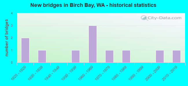
- New bridges - historical statistics
- 21920-1929
- 11930-1939
- 11950-1959
- 31960-1969
- 11970-1979
- 11980-1989
- 12000-2009
- 12010-2019
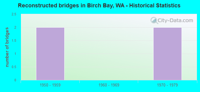
- Reconstructed bridges - Historical Statistics
- 21950-1959
- 01960-1969
- 21970-1979
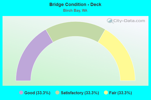
- Bridge Condition - Deck
- 33.3%Good
- 33.3%Satisfactory
- 33.3%Fair
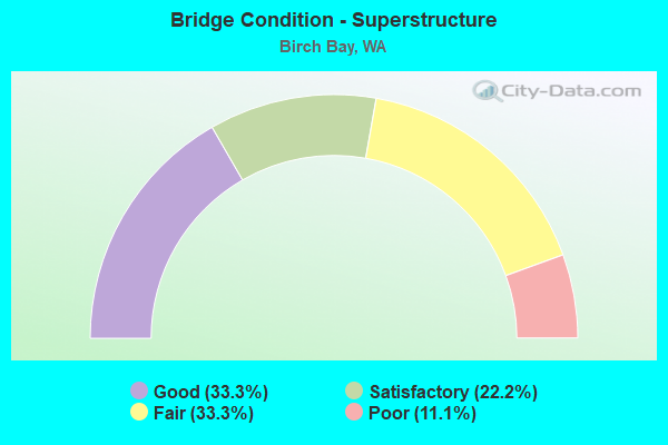
- Bridge Condition - Superstructure
- 33.3%Good
- 22.2%Satisfactory
- 33.3%Fair
- 11.1%Poor
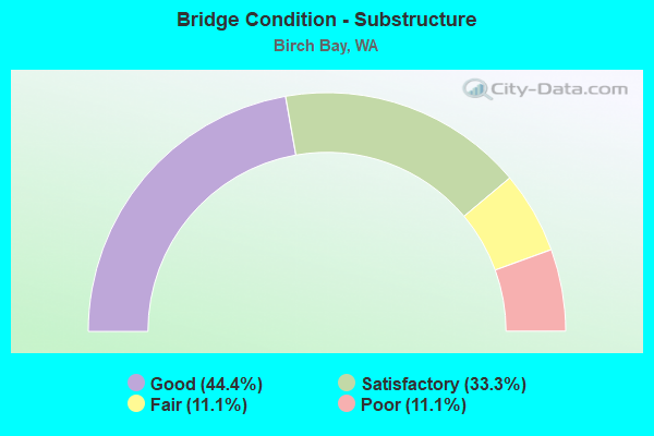
- Bridge Condition - Substructure
- 44.4%Good
- 33.3%Satisfactory
- 11.1%Fair
- 11.1%Poor
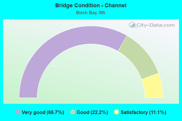
- Bridge Condition - Channel
- 66.7%Very good
- 22.2%Good
- 11.1%Satisfactory
Find on map >> Show street view
Structure Number: 6926D, Location: 5.6 N JCT SR 548 (Lat: 48.949000, Lng: -122.683944), Route carried "on" structure: County highway , Year Built: 1963, Status: Open, Structure Length: 7.25m (23.79ft), Average Daily Traffic: 1,500 (year 2002), Truck Traffic: 5%, Average Future Daily Traffic: 2,520 (year 2036), Design Load: HS 20, Features Intersected: I-5, Facility Carried by Structure: LOOMIS TRAIL RD
Minimum Vertical Clearance: 30+ m (98+ ft), Kilometerpoint: 0.001, Lanes on structure: 2, Lanes under structure: 4, Owner: State Highway Agency, Approaching Roadway Width: 11.6m (38.1ft), Skew: 1 degrees, Material/Design: Prestressed concrete, Design/Construction: Stringer/Multi-beam, Number Of Spans In Main Unit: 5, Length of Maximum Span: 16.8m (55.1ft), Curb or Sidewalk Widths: Left: 0.9m (3.0ft), Right: 0.9m (3.0ft), Curb-To-Curb Width: 7.9m (25.9ft), Out-to-Out Width: 10.1m (33.1ft)
Condition: Deck: Good, Superstructure: Good, Substructure: Good, Operating Rating: 19.8 metric tons, Method Used To Determine Operating Rating: Load and Resistance Factor Rating (LRFR) rating reported by rating factor(RF) method using HL-93 loadings, Inventory Rating: 15.2 metric tons, Method Used To Determine Inventory Rating: Load and Resistance Factor Rating (LRFR) rating reported by rating factor(RF) method using HL-93 loadings, Structural Evaluation: Meets minimum limits, Deck Geometry: Meets minimum limits, Underclear: High priority of corrective action, Approach Roadway Alignment: Equal to present desirable criteria, Length Of Structure Improvement: 7.25m (23.79ft), Designated Inspection Frequency: Every 48 months, Inspection Date: June 2018, Bridge Improvement Cost: $1,904,000, Roadway Improvement Cost: $381,000, Total Project Cost: $3,808,000 ( Estimate for 2014), Deck Structure Type: Concrete Cast-file-Place, Wearing Surface/Protective System: Wearing Surface: Monolithic Concrete
Find on map >> Show street view
Structure Number: 18089A, Location: 4.7 N JCT I-5 (Lat: 48.892111, Lng: -122.698778), Route carried "on" structure: State highway 548, Year Built: 2011, Status: Open, Structure Length: 0.94m (3.08ft), Average Daily Traffic: 5,154 (year 2019), Truck Traffic: 10%, Average Future Daily Traffic: 7,401 (year 2039), Design Load: HL 93, Features Intersected: TERRELL CREEK
Minimum Vertical Clearance: 30+ m (98+ ft), Kilometerpoint: 7.532, Lanes on structure: 2, Owner: State Highway Agency, Approaching Roadway Width: 11.3m (37.1ft), Skew: 3 degrees, Material/Design: Concrete, Design/Construction: Culvert, Number Of Spans In Main Unit: 1, Length of Maximum Span: 9.4m (30.8ft)
Condition: Channel: Satisfactory, Culverts: Good, Operating Rating: 89.8 metric tons, Method Used To Determine Operating Rating: Load Factor (LF), Inventory Rating: 54.4 metric tons, Method Used To Determine Inventory Rating: Load Factor (LF), Structural Evaluation: Better than present minimum criteria, Waterway Adequacy: Equal to present desirable criteria, Approach Roadway Alignment: Equal to present desirable criteria, Length Of Structure Improvement: 0.94m (3.08ft), Designated Inspection Frequency: Every 48 months, Inspection Date: August 2019, Bridge Improvement Cost: $242,000, Roadway Improvement Cost: $48,000, Total Project Cost: $484,000 ( Estimate for 2014)
Find on map >> Show street view
Structure Number: 82365, Location: 10.3 N JCT I-5 (Lat: 48.954528, Lng: -122.726028), Route carried "on" structure: State highway 548, Year Built: 1924, Year Reconstructed: 1956, Status: Open, Structure Length: 3.17m (10.40ft), Average Daily Traffic: 3,738 (year 2019), Truck Traffic: 5%, Average Future Daily Traffic: 5,367 (year 2039), Design Load: HS 15, Features Intersected: CALIFORNIA CR
Minimum Vertical Clearance: 30+ m (98+ ft), Kilometerpoint: 16.496, Lanes on structure: 2, Owner: State Highway Agency, Approaching Roadway Width: 9.1m (29.9ft), Material/Design: Concrete, Design/Construction: Slab, Number Of Spans In Main Unit: 5, Length of Maximum Span: 6.7m (22.0ft), Curb-To-Curb Width: 7.3m (24.0ft), Out-to-Out Width: 8.1m (26.6ft)
Condition: Deck: Good, Superstructure: Good, Substructure: Fair, Channel: Very good, Operating Rating: 35.0 metric tons, Method Used To Determine Operating Rating: Load and Resistance Factor Rating (LRFR) rating reported by rating factor(RF) method using HL-93 loadings, Inventory Rating: 27.2 metric tons, Method Used To Determine Inventory Rating: Load and Resistance Factor Rating (LRFR) rating reported by rating factor(RF) method using HL-93 loadings, Structural Evaluation: Somewhat better than minimum adequacy, Deck Geometry: High priority of replacement, Waterway Adequacy: Equal to present desirable criteria, Approach Roadway Alignment: High priority of corrective action, Length Of Structure Improvement: 3.17m (10.40ft), Designated Inspection Frequency: Every 24 months, Inspection Date: May 2021, Bridge Improvement Cost: $666,000, Roadway Improvement Cost: $133,000, Total Project Cost: $1,331,000 ( Estimate for 2014), Deck Structure Type: Concrete Cast-file-Place, Wearing Surface/Protective System: Wearing Surface: Monolithic Concrete
Find on map >> Show street view
Structure Number: 82367, Location: 00.1 W. BLAINE RD. (Lat: 48.962144, Lng: -122.732900), Route carried "on" structure: County highway 20350, Year Built: 1933, Year Reconstructed: 1950, Status: Open, Structure Length: 3.17m (10.40ft), Average Daily Traffic: 5,920 (year 2018), Truck Traffic: 5%, Average Future Daily Traffic: 7,000 (year 2040), Design Load: H 15, Features Intersected: CALIFORNIA CR, Facility Carried by Structure: DRAYTON HARBOR RD
Minimum Vertical Clearance: 30+ m (98+ ft), Kilometerpoint: 0.001, Lanes on structure: 2, Owner: County Highway Agency, Approaching Roadway Width: 11.3m (37.1ft), Material/Design: Concrete, Design/Construction: Slab, Number Of Spans In Main Unit: 5, Length of Maximum Span: 6.7m (22.0ft), Curb-To-Curb Width: 7.3m (24.0ft), Out-to-Out Width: 7.8m (25.6ft)
Condition: Deck: Satisfactory, Superstructure: Satisfactory, Substructure: Satisfactory, Channel: Very good, Operating Rating: 28.1 metric tons, Method Used To Determine Operating Rating: Load and Resistance Factor (LRFR), Inventory Rating: 21.8 metric tons, Method Used To Determine Inventory Rating: Load and Resistance Factor (LRFR), Structural Evaluation: Somewhat better than minimum adequacy, Deck Geometry: High priority of replacement, Waterway Adequacy: Equal to present desirable criteria, Approach Roadway Alignment: Equal to present minimum criteria, Length Of Structure Improvement: 3.47m (11.38ft), Designated Inspection Frequency: Every 24 months, Inspection Date: Febuary 2021, Bridge Improvement Cost: $1,733,000, Roadway Improvement Cost: $347,000, Total Project Cost: $3,466,000 ( Estimate for 2014), Deck Structure Type: Concrete Cast-file-Place, Wearing Surface/Protective System: Wearing Surface: Monolithic Concrete
Find on map >> Show street view
Structure Number: 82694, Location: 0.02 SW LOOMIS TR (Lat: 48.949847, Lng: -122.711456), Route carried "on" structure: County highway 26290, Year Built: 1922, Year Reconstructed: 1984, Status: Posted for load, Structure Length: 2.59m (8.50ft), Average Daily Traffic: 10 (year 2018), Truck Traffic: 1%, Average Future Daily Traffic: 20 (year 2040), Design Load: H 10, Features Intersected: CALIFORNIA CR, Facility Carried by Structure: BRIDGE WY
Minimum Vertical Clearance: 30+ m (98+ ft), Kilometerpoint: 0.001, Lanes on structure: 1, Owner: County Highway Agency, Approaching Roadway Width: 4.6m (15.1ft), Material/Design: Prestressed concrete, Design/Construction: Stringer/Multi-beam, Number Of Spans In Main Unit: 1, Length of Maximum Span: 25.9m (85.0ft), Curb-To-Curb Width: 4.9m (16.1ft), Out-to-Out Width: 4.9m (16.1ft)
Condition: Deck: Satisfactory, Superstructure: Fair, Substructure: Satisfactory, Channel: Good, Operating Rating: 29.9 metric tons, Method Used To Determine Operating Rating: Field evaluation and documented engineering judgment, Inventory Rating: 18.1 metric tons, Method Used To Determine Inventory Rating: Field evaluation and documented engineering judgment, Structural Evaluation: Somewhat better than minimum adequacy, Deck Geometry: High priority of corrective action, Waterway Adequacy: Equal to present desirable criteria, Approach Roadway Alignment: Equal to present desirable criteria, Bridge Posting: Required (Relationship of Operating Rating to Maximum Legal Load: 0.1 - 9.9% below), Length Of Structure Improvement: 2.90m (9.51ft), Designated Inspection Frequency: Every 12 months, Inspection Date: April 2021, Bridge Improvement Cost: $988,000, Roadway Improvement Cost: $198,000, Total Project Cost: $1,976,000 ( Estimate for 2014), Deck Structure Type: Other, Wearing Surface/Protective System: Wearing Surface: Bituminous
Find on map >> Show street view
Structure Number: 82778, Location: 00.2 S LOOMIS TO RD (Lat: 48.947156, Lng: -122.704367), Route carried "on" structure: County highway 21850, Year Built: 1956, Year Reconstructed: 1976, Status: Open, Structure Length: 5.15m (16.90ft), Average Daily Traffic: 951 (year 2021), Truck Traffic: 2%, Average Future Daily Traffic: 1,200 (year 2041), Design Load: HS 20, Features Intersected: CALIFORNIA CR, Facility Carried by Structure: KICKERVILLE RD
Minimum Vertical Clearance: 30+ m (98+ ft), Kilometerpoint: 0.001, Lanes on structure: 2, Owner: County Highway Agency, Approaching Roadway Width: 9.1m (29.9ft), Skew: 3 degrees, Material/Design: Wood or Timber, Design/Construction: Girder and Floorbeam System, Number Of Spans In Main Unit: 3, Length of Maximum Span: 21.3m (69.9ft), Curb-To-Curb Width: 9.1m (29.9ft), Out-to-Out Width: 9.9m (32.5ft)
Condition: Deck: Good, Superstructure: Good, Substructure: Good, Channel: Very good, Operating Rating: 29.0 metric tons, Method Used To Determine Operating Rating: Load and Resistance Factor (LRFR), Inventory Rating: 21.8 metric tons, Method Used To Determine Inventory Rating: Load and Resistance Factor (LRFR), Structural Evaluation: Somewhat better than minimum adequacy, Deck Geometry: Equal to present minimum criteria, Waterway Adequacy: Equal to present desirable criteria, Approach Roadway Alignment: Equal to present desirable criteria, Length Of Structure Improvement: 5.46m (17.91ft), Designated Inspection Frequency: Every 24 months, Inspection Date: Febuary 2021, Bridge Improvement Cost: $2,721,000, Roadway Improvement Cost: $544,000, Total Project Cost: $5,442,000 ( Estimate for 2014), Deck Structure Type: Concrete Cast-file-Place, Wearing Surface/Protective System: Wearing Surface: Monolithic Concrete
Find on map >> Show street view
Structure Number: 84159, Location: S OF BIRCH BAY DR. (Lat: 48.912644, Lng: -122.748044), Route carried "on" structure: County highway 21950, Year Built: 1975, Status: Posted for load, Structure Length: 1.89m (6.20ft), Average Daily Traffic: 1,037 (year 2019), Truck Traffic: 7%, Average Future Daily Traffic: 1,400 (year 2041), Design Load: H 20, Features Intersected: TERRELL CR, Facility Carried by Structure: JACKSON RD
Minimum Vertical Clearance: 30+ m (98+ ft), Kilometerpoint: 0.001, Lanes on structure: 2, Owner: County Highway Agency, Approaching Roadway Width: 7.9m (25.9ft), Material/Design: Concrete, Design/Construction: Channel Beam, Number Of Spans In Main Unit: 2, Length of Maximum Span: 9.4m (30.8ft), Curb-To-Curb Width: 7.3m (24.0ft), Out-to-Out Width: 7.8m (25.6ft)
Condition: Deck: Fair, Superstructure: Poor, Substructure: Poor, Channel: Very good, Operating Rating: 19.0 metric tons, Method Used To Determine Operating Rating: Load and Resistance Factor (LRFR), Inventory Rating: 14.5 metric tons, Method Used To Determine Inventory Rating: Load and Resistance Factor (LRFR), Structural Evaluation: Meets minimum limits, Deck Geometry: Meets minimum limits, Waterway Adequacy: Equal to present desirable criteria, Approach Roadway Alignment: High priority of corrective action, Bridge Posting: Required (Relationship of Operating Rating to Maximum Legal Load: 20.0 - 29.9% below), Length Of Structure Improvement: 2.19m (7.19ft), Designated Inspection Frequency: Every 12 months, Inspection Date: April 2021, Bridge Improvement Cost: $1,094,000, Roadway Improvement Cost: $219,000, Total Project Cost: $2,189,000 ( Estimate for 2014), Deck Structure Type: Other, Wearing Surface/Protective System: Wearing Surface: Bituminous, Membrane: Other
Find on map >> Show street view
Structure Number: 85799, Location: 0.01 W BIRCHBAY DR (Lat: 48.917711, Lng: -122.745472), Route carried "on" structure: County highway 22450, Year Built: 1987, Status: Open, Structure Length: 1.52m (4.99ft), Average Daily Traffic: 2,766 (year 2018), Truck Traffic: 2%, Average Future Daily Traffic: 4,000 (year 2040), Design Load: H 20, Features Intersected: TERRELL CREEK, Facility Carried by Structure: ALDERSON RD
Minimum Vertical Clearance: 30+ m (98+ ft), Kilometerpoint: 0.001, Lanes on structure: 2, Owner: County Highway Agency, Approaching Roadway Width: 11.0m (36.1ft), Material/Design: Steel, Design/Construction: Channel Beam, Number Of Spans In Main Unit: 2, Length of Maximum Span: 9.4m (30.8ft), Curb or Sidewalk Widths: Left: 1.1m (3.6ft), Right: 1.1m (3.6ft), Curb-To-Curb Width: 11.2m (36.7ft), Out-to-Out Width: 14.3m (46.9ft)
Condition: Deck: Fair, Superstructure: Fair, Substructure: Satisfactory, Channel: Very good, Operating Rating: 29.9 metric tons, Method Used To Determine Operating Rating: Load and Resistance Factor (LRFR), Inventory Rating: 20.9 metric tons, Method Used To Determine Inventory Rating: Load and Resistance Factor (LRFR), Structural Evaluation: Somewhat better than minimum adequacy, Deck Geometry: Somewhat better than minimum adequacy, Waterway Adequacy: Equal to present desirable criteria, Approach Roadway Alignment: Equal to present desirable criteria, Length Of Structure Improvement: 1.83m (6.00ft), Designated Inspection Frequency: Every 24 months, Inspection Date: April 2021, Bridge Improvement Cost: $912,000, Roadway Improvement Cost: $182,000, Total Project Cost: $1,824,000 ( Estimate for 2014), Deck Structure Type: Other, Wearing Surface/Protective System: Wearing Surface: Monolithic Concrete
Find on map >> Show street view
Structure Number: 86472, Location: BIRCH BAY STATE PARK (Lat: 48.903361, Lng: -122.770556), Route carried "on" structure: State lands road 51500, Year Built: 1963, Status: Open, Structure Length: 0.94m (3.08ft), Average Daily Traffic: 135 (year 2012), Average Future Daily Traffic: 171 (year 2036), Design Load: HS 20, Features Intersected: TERRELL CREEK, Facility Carried by Structure: PARK ENTRANCE ROAD
Minimum Vertical Clearance: 30+ m (98+ ft), Kilometerpoint: 0.001, Lanes on structure: 1, Owner: State Park, Forest, or Reservation Agency, Approaching Roadway Width: 6.1m (20.0ft), Material/Design: Concrete, Design/Construction: Channel Beam, Number Of Spans In Main Unit: 1, Length of Maximum Span: 9.4m (30.8ft), Curb or Sidewalk Widths: Left: 1.1m (3.6ft), Right: 0.0m, Curb-To-Curb Width: 3.4m (11.2ft), Out-to-Out Width: 5.2m (17.1ft)
Condition: Deck: Satisfactory, Superstructure: Satisfactory, Substructure: Good, Channel: Good, Operating Rating: 29.9 metric tons, Method Used To Determine Operating Rating: Load Factor (LF), Inventory Rating: 18.1 metric tons, Method Used To Determine Inventory Rating: Load Factor (LF), Structural Evaluation: Somewhat better than minimum adequacy, Deck Geometry: High priority of replacement, Waterway Adequacy: Equal to present minimum criteria, Approach Roadway Alignment: Equal to present desirable criteria, Length Of Structure Improvement: 0.94m (3.08ft), Designated Inspection Frequency: Every 24 months, Inspection Date: March 2021, Bridge Improvement Cost: $136,000, Roadway Improvement Cost: $27,000, Total Project Cost: $273,000 ( Estimate for 2014), Deck Structure Type: Other, Wearing Surface/Protective System: Wearing Surface: Monolithic Concrete
Find on map >> Show street view
Structure Number: 87233, Location: 00.3 N Grandview Road (Lat: 48.896953, Lng: -122.748856), Route carried "on" structure: County highway 21950, Year Built: 2003, Status: Open, Structure Length: 0.94m (3.08ft), Average Daily Traffic: 897 (year 2017), Truck Traffic: 1%, Average Future Daily Traffic: 1,700 (year 2039), Design Load: HS 25 or greater, Features Intersected: TERRELL CREEK, Facility Carried by Structure: JACKSON RD
Minimum Vertical Clearance: 30+ m (98+ ft), Kilometerpoint: 0.001, Lanes on structure: 2, Owner: County Highway Agency, Approaching Roadway Width: 7.9m (25.9ft), Material/Design: Concrete, Design/Construction: Channel Beam, Number Of Spans In Main Unit: 1, Length of Maximum Span: 9.4m (30.8ft), Curb-To-Curb Width: 10.0m (32.8ft), Out-to-Out Width: 10.4m (34.1ft)
Condition: Deck: Fair, Superstructure: Fair, Substructure: Good, Channel: Very good, Operating Rating: 34.5 metric tons, Method Used To Determine Operating Rating: Load and Resistance Factor (LRFR), Inventory Rating: 24.5 metric tons, Method Used To Determine Inventory Rating: Load and Resistance Factor (LRFR), Structural Evaluation: Somewhat better than minimum adequacy, Deck Geometry: Equal to present minimum criteria, Waterway Adequacy: Equal to present desirable criteria, Approach Roadway Alignment: Equal to present desirable criteria, Length Of Structure Improvement: 1.25m (4.10ft), Designated Inspection Frequency: Every 24 months, Inspection Date: Febuary 2021, Bridge Improvement Cost: $623,000, Roadway Improvement Cost: $125,000, Total Project Cost: $1,246,000 ( Estimate for 2014), Deck Structure Type: Other, Wearing Surface/Protective System: Wearing Surface: Monolithic Concrete, Deck Protection: Epoxy Coated Reinforcing
Find on map >> Show street view
Structure Number: 6926D, Location: 5.6 N JCT SR 548 (Lat: 48.949000, Lng: -122.683944), Route carried "under" structure: Interstate 5, Year Built: 1963, Structure Length: 0. m, Average Daily Traffic: 26,988 (year 2019), Truck Traffic: 9%, Features Intersected: I-5, Facility Carried by Structure: LOOMIS TRAIL RD
Minimum Vertical Clearance: 5.05m (16.57ft), Kilometerpoint: 437.098, Lanes on structure: 2, Lanes under structure: 4, Material/Design: Prestressed concrete, Design/Construction: Stringer/Multi-beam, Length of Maximum Span: 16.8m (55.1ft)