Bridge Statistics for Billerica, Massachusetts (MA)
Condition, Traffic, Stress, Structural Evaluation, Project Costs
- National Bridge Inventory (NBI) Statistics
- 21Number of bridges
- 289ft / 88.2mTotal length
- $38,155,000Total costs
- 434,325Total average daily traffic
- 31,356Total average daily truck traffic
- 672,073Total future (year 2031) average daily traffic
- National Bridge Inventory (NBI) Registered Bridges for Billerica
- No street view available for this location
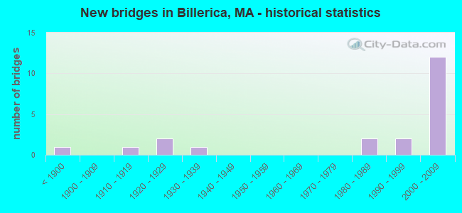
- New bridges - historical statistics
- 1Before 1900
- 11910-1919
- 21920-1929
- 11930-1939
- 21980-1989
- 21990-1999
- 122000-2009

- Reconstructed bridges - Historical Statistics
- 11930-1939
- 01940-1949
- 01950-1959
- 01960-1969
- 01970-1979
- 01980-1989
- 01990-1999
- 12000-2009


- Bridge Condition - Deck
- 61.1%Good
- 22.2%Satisfactory
- 16.7%Fair

- Bridge Condition - Superstructure
- 42.9%Good
- 28.6%Satisfactory
- 28.6%Fair

- Bridge Condition - Substructure
- 52.4%Good
- 28.6%Satisfactory
- 19.0%Fair

- Bridge Condition - Channel
- 66.7%Good
- 22.2%Satisfactory
- 11.1%Fair
Find on map >> Show street view
Structure Number: B120019CPDOTNBI, Location: I.0 MILE N. OF BEDFD LINE (Lat: 42.534944, Lng: -71.299583), Route carried "on" structure: State highway 4, Year Built: 2008, Status: Open, Structure Length: 4.81m (15.78ft), Average Daily Traffic: 13,600 (year 2019), Truck Traffic: 10%, Average Future Daily Traffic: 15,003 (year 2032), Design Load: HS 20, Features Intersected: WATER CONCORD RIVER
Minimum Vertical Clearance: 30+ m (98+ ft), Kilometerpoint: 16.431, Lanes on structure: 2, Owner: State Highway Agency, Approaching Roadway Width: 13.5m (44.3ft), Material/Design: Steel continuous, Design/Construction: Stringer/Multi-beam, Number Of Spans In Main Unit: 3, Length of Maximum Span: 16.5m (54.1ft), Curb or Sidewalk Widths: Left: 1.6m (5.2ft), Right: 0.0m, Curb-To-Curb Width: 12.5m (41.0ft), Out-to-Out Width: 15.0m (49.2ft)
Condition: Deck: Good, Superstructure: Good, Substructure: Good, Channel: Good, Operating Rating: 96.8 metric tons, Method Used To Determine Operating Rating: Load Factor (LF), Inventory Rating: 58.0 metric tons, Method Used To Determine Inventory Rating: Load Factor (LF), Structural Evaluation: Better than present minimum criteria, Deck Geometry: Somewhat better than minimum adequacy, Waterway Adequacy: Equal to present minimum criteria, Approach Roadway Alignment: Equal to present desirable criteria, Length Of Structure Improvement: 4.90m (16.08ft), Designated Inspection Frequency: Every 24 months, Underwater Inspection Frequency: Every 36 months, Inspection Date: March 2021, Underwater Inspection Date: April 2019, Bridge Improvement Cost: $416,000, Roadway Improvement Cost: $42,000, Total Project Cost: $625,000 ( Estimate for 2022), Deck Structure Type: Concrete Cast-file-Place, Wearing Surface/Protective System: Wearing Surface: Bituminous, Membrane: Other, Deck Protection: Epoxy Coated Reinforcing
Find on map >> Show street view
Structure Number: B12002ANJMUNNBI, Location: .8 M SE OF RTE 3 (Lat: 42.557486, Lng: -71.282556), Route carried "on" structure: City street , Year Built: 2003, Status: Open, Structure Length: 4.57m (14.99ft), Average Daily Traffic: 12,900 (year 2021), Truck Traffic: 5%, Average Future Daily Traffic: 9,160 (year 2032), Design Load: HS 20, Features Intersected: WATER CONCORD RIVER, Facility Carried by Structure: HWY RIVER ST
Minimum Vertical Clearance: 30+ m (98+ ft), Kilometerpoint: 1.271, Lanes on structure: 2, Owner: Town or Township Highway Agency, Approaching Roadway Width: 9.1m (29.9ft), Navigation Control: Yes ( Vertical Clearance: 1.8m (5.9ft), Horizontal Clearance: 13.8m (45.3ft)), Material/Design: Steel continuous, Design/Construction: Stringer/Multi-beam, Number Of Spans In Main Unit: 2, Length of Maximum Span: 21.9m (71.9ft), Curb or Sidewalk Widths: Left: 0.0m, Right: 1.8m (5.9ft), Curb-To-Curb Width: 9.1m (29.9ft), Out-to-Out Width: 11.4m (37.4ft)
Condition: Deck: Good, Superstructure: Satisfactory, Substructure: Good, Channel: Good, Operating Rating: 51.0 metric tons, Method Used To Determine Operating Rating: Load Factor (LF), Inventory Rating: 30.5 metric tons, Method Used To Determine Inventory Rating: Load Factor (LF), Structural Evaluation: Equal to present minimum criteria, Deck Geometry: High priority of corrective action, Waterway Adequacy: Superior to present desirable criteria, Approach Roadway Alignment: Equal to present minimum criteria, Length Of Structure Improvement: 4.60m (15.09ft), Designated Inspection Frequency: Every 24 months, Underwater Inspection Frequency: Every 36 months, Inspection Date: June 2021, Underwater Inspection Date: March 2021, Bridge Improvement Cost: $2,060,000, Roadway Improvement Cost: $207,000, Total Project Cost: $3,091,000 ( Estimate for 2022), Deck Structure Type: Concrete Cast-file-Place, Wearing Surface/Protective System: Wearing Surface: Bituminous, Membrane: Built-up, Deck Protection: Epoxy Coated Reinforcing
Find on map >> Show street view
Structure Number: B120032DGDOTNBI, Location: 1 MI N OF BILLERICA CTR (Lat: 42.574100, Lng: -71.280225), Route carried "on" structure: Alternate State highway 3A, Year Built: 1920, Status: Open, Structure Length: 5.49m (18.01ft), Average Daily Traffic: 19,655 (year 2018), Truck Traffic: 8%, Average Future Daily Traffic: 34,745 (year 2031), Design Load: H 20, Features Intersected: WATER CONCORD RIVER, Facility Carried by Structure: ST 3 A/BOSTON RD
Minimum Vertical Clearance: 30+ m (98+ ft), Kilometerpoint: 98.087, Lanes on structure: 2, Base Highway Network: Yes, Owner: State Highway Agency, Approaching Roadway Width: 9.1m (29.9ft), Material/Design: Concrete, Design/Construction: Arch - Deck, Number Of Spans In Main Unit: 3, Length of Maximum Span: 19.8m (65.0ft), Curb or Sidewalk Widths: Left: 0.0m, Right: 1.8m (5.9ft), Curb-To-Curb Width: 9.2m (30.2ft), Out-to-Out Width: 12.1m (39.7ft)
Condition: Superstructure: Good, Substructure: Fair, Channel: Good, Operating Rating: 93.2 metric tons, Method Used To Determine Operating Rating: Load Factor (LF), Inventory Rating: 56.8 metric tons, Method Used To Determine Inventory Rating: Load Factor (LF), Structural Evaluation: Somewhat better than minimum adequacy, Deck Geometry: High priority of corrective action, Waterway Adequacy: Equal to present desirable criteria, Approach Roadway Alignment: Equal to present minimum criteria, Length Of Structure Improvement: 5.50m (18.04ft), Designated Inspection Frequency: Every 24 months, Underwater Inspection Frequency: Every 36 months, Inspection Date: October 2020, Underwater Inspection Date: April 2021, Bridge Improvement Cost: $2,615,000, Roadway Improvement Cost: $262,000, Total Project Cost: $3,923,000 ( Estimate for 2022), Wearing Surface/Protective System: Wearing Surface: Bituminous
Find on map >> Show street view
Structure Number: B12005ARCMUNNBI, Location: AT JCT TREBLE COVE RD (Lat: 42.585008, Lng: -71.287131), Route carried "on" structure: City street , Year Built: 1998, Status: Open, Structure Length: 7.33m (24.05ft), Average Daily Traffic: 5,500 (year 2018), Truck Traffic: 7%, Average Future Daily Traffic: 16,425 (year 2031), Design Load: HS 20, Features Intersected: WATER CONCORD RIVER, Facility Carried by Structure: HWY POLLARD ST
Minimum Vertical Clearance: 30+ m (98+ ft), Kilometerpoint: 1.851, Lanes on structure: 2, Owner: Town or Township Highway Agency, Approaching Roadway Width: 10.5m (34.4ft), Skew: 4 degrees, Material/Design: Prestressed concrete, Design/Construction: Box Beam or Girders - Single/Spread, Number Of Spans In Main Unit: 3, Length of Maximum Span: 24.6m (80.7ft), Curb or Sidewalk Widths: Left: 1.8m (5.9ft), Right: 1.8m (5.9ft), Curb-To-Curb Width: 10.5m (34.4ft), Out-to-Out Width: 14.8m (48.6ft)
Condition: Deck: Fair, Superstructure: Fair, Substructure: Satisfactory, Channel: Good, Operating Rating: 72.7 metric tons, Method Used To Determine Operating Rating: Load Factor (LF), Inventory Rating: 43.5 metric tons, Method Used To Determine Inventory Rating: Load Factor (LF), Structural Evaluation: Somewhat better than minimum adequacy, Deck Geometry: Meets minimum limits, Waterway Adequacy: Superior to present desirable criteria, Approach Roadway Alignment: High priority of corrective action, Length Of Structure Improvement: 7.40m (24.28ft), Designated Inspection Frequency: Every 24 months, Inspection Date: July 2020, Bridge Improvement Cost: $4,302,000, Roadway Improvement Cost: $431,000, Total Project Cost: $6,454,000 ( Estimate for 2022), Deck Structure Type: Concrete Cast-file-Place, Wearing Surface/Protective System: Wearing Surface: Bituminous, Deck Protection: Epoxy Coated Reinforcing
Find on map >> Show street view
Structure Number: B120062BBMUNNBI, Location: 1.2 KM E OF RTE 3A (Lat: 42.591839, Lng: -71.284089), Route carried "on" structure: City street , Year Built: 1850, Status: Posted for load, Structure Length: 3.14m (10.30ft), Average Daily Traffic: 6,871 (year 2020), Truck Traffic: 8%, Average Future Daily Traffic: 14,056 (year 2032), Features Intersected: WATER CONCORD RIVER, Facility Carried by Structure: HWY FAULKNER ST
Minimum Vertical Clearance: 30+ m (98+ ft), Kilometerpoint: 0.451, Lanes on structure: 2, Owner: Town or Township Highway Agency, Approaching Roadway Width: 7.6m (24.9ft), Skew: 1 degrees, Material/Design: Concrete, Design/Construction: Arch - Deck, Number Of Spans In Main Unit: 2, Length of Maximum Span: 14.9m (48.9ft), Curb or Sidewalk Widths: Left: 1.5m (4.9ft), Right: 0.0m, Curb-To-Curb Width: 7.1m (23.3ft), Out-to-Out Width: 9.0m (29.5ft)
Condition: Superstructure: Fair, Substructure: Satisfactory, Channel: Satisfactory, Operating Rating: 43.1 metric tons, Method Used To Determine Operating Rating: Load Factor (LF), Inventory Rating: 25.8 metric tons, Method Used To Determine Inventory Rating: Load Factor (LF), Structural Evaluation: Somewhat better than minimum adequacy, Deck Geometry: High priority of replacement, Waterway Adequacy: Equal to present desirable criteria, Approach Roadway Alignment: Somewhat better than minimum adequacy, Length Of Structure Improvement: 3.20m (10.50ft), Designated Inspection Frequency: Every 24 months, Underwater Inspection Frequency: Every 36 months, Inspection Date: September 2021, Underwater Inspection Date: August 2019, Bridge Improvement Cost: $1,132,000, Roadway Improvement Cost: $114,000, Total Project Cost: $1,699,000 ( Estimate for 2022), Wearing Surface/Protective System: Wearing Surface: Bituminous
Find on map >> Show street view
Structure Number: B120082KRDOTNBI, Location: 0.75 MI E SALEM & BALDWIN (Lat: 42.568061, Lng: -71.215103), Route carried "on" structure: State highway 129, Year Built: 1932, Status: Posted for load, Structure Length: 0.64m (2.10ft), Average Daily Traffic: 10,600 (year 2018), Truck Traffic: 5%, Average Future Daily Traffic: 20,689 (year 2033), Features Intersected: WATER SHAWSHEEN RIVER
Minimum Vertical Clearance: 30+ m (98+ ft), Kilometerpoint: 0.000, Lanes on structure: 2, Owner: State Highway Agency, Approaching Roadway Width: 9.1m (29.9ft), Material/Design: Masonry, Design/Construction: Arch - Deck, Number Of Spans In Main Unit: 1, Length of Maximum Span: 6.4m (21.0ft), Curb-To-Curb Width: 9.1m (29.9ft), Out-to-Out Width: 12.2m (40.0ft)
Condition: Superstructure: Fair, Substructure: Satisfactory, Channel: Satisfactory, Structural Evaluation: Somewhat better than minimum adequacy, Deck Geometry: High priority of corrective action, Waterway Adequacy: Equal to present minimum criteria, Approach Roadway Alignment: Equal to present minimum criteria, Length Of Structure Improvement: 0.70m (2.30ft), Designated Inspection Frequency: Every 24 months, Underwater Inspection Frequency: Every 36 months, Inspection Date: Febuary 2022, Underwater Inspection Date: Febuary 2020, Bridge Improvement Cost: $336,000, Roadway Improvement Cost: $34,000, Total Project Cost: $505,000 ( Estimate for 2022), Wearing Surface/Protective System: Wearing Surface: Bituminous
Find on map >> Show street view
Structure Number: B120092DFDOTNBI, Location: 0.25 MI E RT3A/ALLEN RD (Lat: 42.534572, Lng: -71.233547), Route carried "on" structure: Alternate State highway 3A, Year Built: 1915, Year Reconstructed: 1930, Status: Posted for load, Structure Length: 0.85m (2.79ft), Average Daily Traffic: 19,400 (year 2016), Truck Traffic: 5%, Average Future Daily Traffic: 34,745 (year 2031), Design Load: H 20, Features Intersected: WATER SHAWSHEEN RIVER, Facility Carried by Structure: ST 3 A/BOSTON RD
Minimum Vertical Clearance: 30+ m (98+ ft), Kilometerpoint: 91.799, Lanes on structure: 2, Base Highway Network: Yes, Owner: State Highway Agency, Approaching Roadway Width: 15.5m (50.9ft), Skew: 1 degrees, Material/Design: Concrete, Design/Construction: Tee Beam, Number Of Spans In Main Unit: 1, Length of Maximum Span: 7.6m (24.9ft), Curb or Sidewalk Widths: Left: 1.8m (5.9ft), Right: 1.8m (5.9ft), Curb-To-Curb Width: 15.5m (50.9ft), Out-to-Out Width: 20.2m (66.3ft)
Condition: Deck: Satisfactory, Superstructure: Fair, Substructure: Fair, Channel: Fair, Operating Rating: 38.1 metric tons, Method Used To Determine Operating Rating: Load Factor (LF), Inventory Rating: 22.9 metric tons, Method Used To Determine Inventory Rating: Load Factor (LF), Structural Evaluation: Somewhat better than minimum adequacy, Deck Geometry: Superior to present desirable criteria, Waterway Adequacy: Equal to present desirable criteria, Approach Roadway Alignment: Better than present minimum criteria, Length Of Structure Improvement: 0.90m (2.95ft), Designated Inspection Frequency: Every 12 months, Underwater Inspection Frequency: Every 12 months, Inspection Date: October 2020, Underwater Inspection Date: December 2021, Bridge Improvement Cost: $715,000, Roadway Improvement Cost: $72,000, Total Project Cost: $1,073,000 ( Estimate for 2022), Deck Structure Type: Concrete Cast-file-Place, Wearing Surface/Protective System: Wearing Surface: Bituminous
Find on map >> Show street view
Structure Number: B120112MRDOT634, Location: 1 MI S RT 3A & WOBURN ST (Lat: 42.602306, Lng: -71.284486), Route carried "on" structure: State highway , Year Built: 1925, Year Reconstructed: 2008, Status: Open, Structure Length: 1.04m (3.41ft), Average Daily Traffic: 800 (year 2018), Truck Traffic: 17%, Average Future Daily Traffic: 1,895 (year 2031), Design Load: HS 20, Features Intersected: RR MBTA/BMRR, Facility Carried by Structure: HWY TOWN FARM LN
Minimum Vertical Clearance: 30+ m (98+ ft), Kilometerpoint: 0.000, Lanes on structure: 1, Owner: State Highway Agency, Approaching Roadway Width: 3.7m (12.1ft), Material/Design: Steel, Design/Construction: Stringer/Multi-beam, Number Of Spans In Main Unit: 1, Length of Maximum Span: 9.8m (32.2ft), Curb-To-Curb Width: 3.7m (12.1ft), Out-to-Out Width: 4.5m (14.8ft)
Condition: Deck: Good, Superstructure: Good, Substructure: Good, Operating Rating: 37.9 metric tons, Method Used To Determine Operating Rating: Load Factor (LF), Inventory Rating: 22.7 metric tons, Method Used To Determine Inventory Rating: Load Factor (LF), Structural Evaluation: Equal to present minimum criteria, Deck Geometry: High priority of replacement, Underclear: High priority of replacement, Approach Roadway Alignment: Meets minimum limits, Length Of Structure Improvement: 1.80m (5.91ft), Designated Inspection Frequency: Every 24 months, Inspection Date: November 2020, Bridge Improvement Cost: $1,226,000, Roadway Improvement Cost: $123,000, Total Project Cost: $1,840,000 ( Estimate for 2022), Deck Structure Type: Corrugated Steel, Wearing Surface/Protective System: Wearing Surface: Bituminous, Membrane: Other, Deck Protection: Epoxy Coated Reinforcing
Find on map >> Show street view
Structure Number: B120122MVDOT634, Location: .4 MILES TWKS. TWN. LINE (Lat: 42.580403, Lng: -71.237467), Route carried "on" structure: State highway , Year Built: 1996, Status: Open, Structure Length: 3.81m (12.50ft), Average Daily Traffic: 4,300 (year 2017), Truck Traffic: 10%, Average Future Daily Traffic: 6,001 (year 2032), Design Load: HS 20, Features Intersected: RR MBTA/BMRR, Facility Carried by Structure: HWY GRAY ST
Minimum Vertical Clearance: 30+ m (98+ ft), Kilometerpoint: 0.644, Lanes on structure: 2, Owner: State Highway Agency, Approaching Roadway Width: 7.3m (24.0ft), Material/Design: Prestressed concrete continuous, Design/Construction: Slab, Number Of Spans In Main Unit: 3, Length of Maximum Span: 15.8m (51.8ft), Curb or Sidewalk Widths: Left: 1.8m (5.9ft), Right: 0.2m (0.7ft), Curb-To-Curb Width: 7.3m (24.0ft), Out-to-Out Width: 10.1m (33.1ft)
Condition: Deck: Good, Superstructure: Good, Substructure: Good, Operating Rating: 59.7 metric tons, Method Used To Determine Operating Rating: Load Factor (LF), Inventory Rating: 35.5 metric tons, Method Used To Determine Inventory Rating: Load Factor (LF), Structural Evaluation: Better than present minimum criteria, Deck Geometry: High priority of replacement, Underclear: High priority of corrective action, Approach Roadway Alignment: Somewhat better than minimum adequacy, Length Of Structure Improvement: 3.90m (12.80ft), Designated Inspection Frequency: Every 24 months, Inspection Date: Febuary 2021, Bridge Improvement Cost: $2,244,000, Roadway Improvement Cost: $225,000, Total Project Cost: $3,367,000 ( Estimate for 2022), Deck Structure Type: Concrete Precast Panels, Wearing Surface/Protective System: Wearing Surface: Bituminous, Membrane: Other, Deck Protection: Epoxy Coated Reinforcing
Find on map >> Show street view
Structure Number: B12013AN2DOT634, Location: 0.1 MI NE ANDOVER & SALEM (Lat: 42.577650, Lng: -71.231256), Route carried "on" structure: State highway , Year Built: 2006, Status: Open, Structure Length: 2.04m (6.69ft), Average Daily Traffic: 6,207 (year 2019), Truck Traffic: 10%, Average Future Daily Traffic: 7,581 (year 2032), Design Load: HS 20, Features Intersected: RR MBTA/BMRR, Facility Carried by Structure: HWY ANDOVER RD
Minimum Vertical Clearance: 30+ m (98+ ft), Kilometerpoint: 0.000, Lanes on structure: 2, Owner: State Highway Agency, Approaching Roadway Width: 8.7m (28.5ft), Skew: 3 degrees, Material/Design: Prestressed concrete, Design/Construction: Box Beam or Girders - Multiple, Number Of Spans In Main Unit: 1, Length of Maximum Span: 18.5m (60.7ft), Curb or Sidewalk Widths: Left: 0.0m, Right: 1.6m (5.2ft), Curb-To-Curb Width: 7.1m (23.3ft), Out-to-Out Width: 9.3m (30.5ft)
Condition: Deck: Good, Superstructure: Good, Substructure: Satisfactory, Operating Rating: 74.7 metric tons, Method Used To Determine Operating Rating: Load Factor (LF), Inventory Rating: 41.5 metric tons, Method Used To Determine Inventory Rating: Load Factor (LF), Structural Evaluation: Equal to present minimum criteria, Deck Geometry: High priority of replacement, Underclear: High priority of corrective action, Approach Roadway Alignment: Meets minimum limits, Length Of Structure Improvement: 2.10m (6.89ft), Designated Inspection Frequency: Every 24 months, Inspection Date: September 2021, Bridge Improvement Cost: $1,248,000, Roadway Improvement Cost: $125,000, Total Project Cost: $1,873,000 ( Estimate for 2022), Deck Structure Type: Concrete Precast Panels, Wearing Surface/Protective System: Wearing Surface: Bituminous, Membrane: Built-up, Deck Protection: Epoxy Coated Reinforcing
Find on map >> Show street view
Structure Number: B12014AF7DOT634, Location: .16 KM NE SALEM & BROWN (Lat: 42.571319, Lng: -71.216847), Route carried "on" structure: State highway , Year Built: 2005, Status: Open, Structure Length: 1.63m (5.35ft), Average Daily Traffic: 1,700 (year 2017), Truck Traffic: 6%, Average Future Daily Traffic: 3,001 (year 2032), Design Load: HS 20, Features Intersected: RR MBTA/BMRR, Facility Carried by Structure: HWY GEO BROWN ST
Minimum Vertical Clearance: 30+ m (98+ ft), Kilometerpoint: 0.000, Lanes on structure: 2, Owner: State Highway Agency, Approaching Roadway Width: 6.7m (22.0ft), Material/Design: Prestressed concrete, Design/Construction: Slab, Number Of Spans In Main Unit: 1, Length of Maximum Span: 15.2m (49.9ft), Curb or Sidewalk Widths: Left: 1.5m (4.9ft), Right: 0.0m, Curb-To-Curb Width: 6.7m (22.0ft), Out-to-Out Width: 8.9m (29.2ft)
Condition: Deck: Satisfactory, Superstructure: Satisfactory, Substructure: Satisfactory, Operating Rating: 73.9 metric tons, Method Used To Determine Operating Rating: Load Factor (LF), Inventory Rating: 44.4 metric tons, Method Used To Determine Inventory Rating: Load Factor (LF), Structural Evaluation: Equal to present minimum criteria, Deck Geometry: High priority of corrective action, Underclear: High priority of corrective action, Approach Roadway Alignment: Meets minimum limits, Length Of Structure Improvement: 1.70m (5.58ft), Designated Inspection Frequency: Every 24 months, Inspection Date: Febuary 2021, Bridge Improvement Cost: $1,074,000, Roadway Improvement Cost: $108,000, Total Project Cost: $1,612,000 ( Estimate for 2022), Deck Structure Type: Concrete Precast Panels, Wearing Surface/Protective System: Wearing Surface: Bituminous, Membrane: Other, Deck Protection: Epoxy Coated Reinforcing
Find on map >> Show street view
Structure Number: B120152MUDOT634, Location: 1 MI NE SALEM & POND (Lat: 42.587747, Lng: -71.254228), Route carried "on" structure: City street , Year Built: 1986, Status: Open, Structure Length: 2.35m (7.71ft), Average Daily Traffic: 5,400 (year 2020), Truck Traffic: 5%, Average Future Daily Traffic: 5,528 (year 2033), Design Load: HS 20, Features Intersected: RR MBTA/BMRR, Facility Carried by Structure: HWY POND ST
Minimum Vertical Clearance: 30+ m (98+ ft), Kilometerpoint: 0.000, Lanes on structure: 2, Owner: State Highway Agency, Approaching Roadway Width: 11.6m (38.1ft), Skew: 2 degrees, Material/Design: Prestressed concrete, Design/Construction: Box Beam or Girders - Multiple, Number Of Spans In Main Unit: 1, Length of Maximum Span: 21.9m (71.9ft), Curb or Sidewalk Widths: Left: 0.3m (1.0ft), Right: 2.0m (6.6ft), Curb-To-Curb Width: 11.6m (38.1ft), Out-to-Out Width: 14.5m (47.6ft)
Condition: Deck: Fair, Superstructure: Fair, Substructure: Fair, Operating Rating: 66.7 metric tons, Method Used To Determine Operating Rating: Load Factor (LF), Inventory Rating: 34.4 metric tons, Method Used To Determine Inventory Rating: Load Factor (LF), Structural Evaluation: Somewhat better than minimum adequacy, Deck Geometry: Somewhat better than minimum adequacy, Underclear: Meets minimum limits, Approach Roadway Alignment: Equal to present minimum criteria, Length Of Structure Improvement: 2.40m (7.87ft), Designated Inspection Frequency: Every 24 months, Inspection Date: Febuary 2022, Bridge Improvement Cost: $1,367,000, Roadway Improvement Cost: $137,000, Total Project Cost: $2,051,000 ( Estimate for 2022), Deck Structure Type: Concrete Precast Panels, Wearing Surface/Protective System: Wearing Surface: Bituminous
Find on map >> Show street view
Structure Number: B120162MTDOT634, Location: 0.8 KM NE ROGERS ST (Lat: 42.587914, Lng: -71.271550), Route carried "on" structure: City street , Year Built: 1986, Status: Open, Structure Length: 1.55m (5.09ft), Average Daily Traffic: 4,500 (year 2020), Truck Traffic: 6%, Average Future Daily Traffic: 7,739 (year 2031), Design Load: HS 20, Features Intersected: RR MBTA/BMRR, Facility Carried by Structure: HWY HIGH ST
Minimum Vertical Clearance: 30+ m (98+ ft), Kilometerpoint: 0.000, Lanes on structure: 2, Owner: State Highway Agency, Approaching Roadway Width: 10.4m (34.1ft), Material/Design: Prestressed concrete, Design/Construction: Box Beam or Girders - Multiple, Number Of Spans In Main Unit: 1, Length of Maximum Span: 14.6m (47.9ft), Curb or Sidewalk Widths: Left: 0.2m (0.7ft), Right: 1.5m (4.9ft), Curb-To-Curb Width: 10.4m (34.1ft), Out-to-Out Width: 13.0m (42.7ft)
Condition: Deck: Fair, Superstructure: Fair, Substructure: Fair, Operating Rating: 67.7 metric tons, Method Used To Determine Operating Rating: Load Factor (LF), Inventory Rating: 40.2 metric tons, Method Used To Determine Inventory Rating: Load Factor (LF), Structural Evaluation: Somewhat better than minimum adequacy, Deck Geometry: Somewhat better than minimum adequacy, Underclear: Meets minimum limits, Approach Roadway Alignment: Meets minimum limits, Length Of Structure Improvement: 1.60m (5.25ft), Designated Inspection Frequency: Every 24 months, Inspection Date: December 2020, Bridge Improvement Cost: $818,000, Roadway Improvement Cost: $82,000, Total Project Cost: $1,228,000 ( Estimate for 2022), Deck Structure Type: Concrete Precast Panels, Wearing Surface/Protective System: Wearing Surface: Bituminous, Membrane: Built-up
Find on map >> Show street view
Structure Number: B12021AY8DOTNBI, Location: 1.6 KM N RTE 4 (Lat: 42.542800, Lng: -71.283553), Route carried "on" structure: City street , Year Built: 2004, Status: Open, Structure Length: 9.17m (30.09ft), Average Daily Traffic: 23,405 (year 2019), Truck Traffic: 6%, Average Future Daily Traffic: 53,222 (year 2032), Design Load: HS 25 or greater, Features Intersected: US 3, Facility Carried by Structure: HWY CONCORD RD
Minimum Vertical Clearance: 30+ m (98+ ft), Kilometerpoint: 1.609, Lanes on structure: 4, Lanes under structure: 8, Owner: State Highway Agency, Approaching Roadway Width: 18.9m (62.0ft), Skew: 4 degrees, Material/Design: Steel continuous, Design/Construction: Stringer/Multi-beam, Number Of Spans In Main Unit: 2, Length of Maximum Span: 44.8m (147.0ft), Curb or Sidewalk Widths: Left: 0.0m, Right: 1.7m (5.6ft), Curb-To-Curb Width: 18.9m (62.0ft), Out-to-Out Width: 22.5m (73.8ft)
Condition: Deck: Good, Superstructure: Satisfactory, Substructure: Good, Inventory Rating: 60.3 metric tons, Method Used To Determine Inventory Rating: Load Factor (LF), Structural Evaluation: Equal to present minimum criteria, Deck Geometry: Equal to present minimum criteria, Underclear: High priority of corrective action, Approach Roadway Alignment: Equal to present desirable criteria, Length Of Structure Improvement: 9.20m (30.18ft), Designated Inspection Frequency: Every 24 months, Inspection Date: July 2021, Bridge Improvement Cost: $2,776,000, Roadway Improvement Cost: $278,000, Total Project Cost: $4,165,000 ( Estimate for 2022), Deck Structure Type: Concrete Cast-file-Place, Wearing Surface/Protective System: Wearing Surface: Integral Concrete, Deck Protection: Epoxy Coated Reinforcing
Find on map >> Show street view
Structure Number: B120228G2DOTNBI, Location: 0.5 MI NW RT3 & CNCRD RD (Lat: 42.548192, Lng: -71.287444), Route carried "on" structure: US 3, Year Built: 2004, Status: Open, Structure Length: 6.22m (20.41ft), Average Daily Traffic: 81,500 (year 2019), Truck Traffic: 5%, Average Future Daily Traffic: 94,600 (year 2032), Design Load: HS 25 or greater, Features Intersected: WATER CONCORD RIVER
Minimum Vertical Clearance: 30+ m (98+ ft), Kilometerpoint: 120.054, Lanes on structure: 3, Base Highway Network: Yes, Owner: State Highway Agency, Approaching Roadway Width: 22.8m (74.8ft), Skew: 1 degrees, Material/Design: Steel, Design/Construction: Stringer/Multi-beam, Number Of Spans In Main Unit: 1, Length of Maximum Span: 60.0m (196.9ft), Curb-To-Curb Width: 22.9m (75.1ft), Out-to-Out Width: 23.9m (78.4ft)
Condition: Deck: Good, Superstructure: Good, Substructure: Good, Channel: Good, Operating Rating: 94.8 metric tons, Method Used To Determine Operating Rating: Load Factor (LF), Inventory Rating: 56.8 metric tons, Method Used To Determine Inventory Rating: Load Factor (LF), Structural Evaluation: Better than present minimum criteria, Deck Geometry: Superior to present desirable criteria, Waterway Adequacy: Equal to present desirable criteria, Approach Roadway Alignment: Equal to present desirable criteria, Designated Inspection Frequency: Every 24 months, Inspection Date: June 2021, Deck Structure Type: Concrete Cast-file-Place, Wearing Surface/Protective System: Wearing Surface: Monolithic Concrete, Deck Protection: Epoxy Coated Reinforcing
Find on map >> Show street view
Structure Number: B120228G3DOTNBI, Location: 0.5 MI NW RT3 & CNCRD RD (Lat: 42.547972, Lng: -71.287750), Route carried "on" structure: US 3, Year Built: 2004, Status: Open, Structure Length: 6.22m (20.41ft), Average Daily Traffic: 86,400 (year 2019), Truck Traffic: 5%, Average Future Daily Traffic: 130,766 (year 2032), Design Load: HS 25 or greater, Features Intersected: WATER CONCORD RIVER
Minimum Vertical Clearance: 30+ m (98+ ft), Kilometerpoint: 120.054, Lanes on structure: 3, Base Highway Network: Yes, Owner: State Highway Agency, Approaching Roadway Width: 22.8m (74.8ft), Skew: 1 degrees, Material/Design: Steel, Design/Construction: Stringer/Multi-beam, Number Of Spans In Main Unit: 1, Length of Maximum Span: 60.0m (196.9ft), Curb-To-Curb Width: 22.9m (75.1ft), Out-to-Out Width: 23.9m (78.4ft)
Condition: Deck: Good, Superstructure: Good, Substructure: Good, Channel: Good, Operating Rating: 94.8 metric tons, Method Used To Determine Operating Rating: Load Factor (LF), Inventory Rating: 56.8 metric tons, Method Used To Determine Inventory Rating: Load Factor (LF), Structural Evaluation: Better than present minimum criteria, Deck Geometry: Superior to present desirable criteria, Waterway Adequacy: Equal to present desirable criteria, Approach Roadway Alignment: Equal to present desirable criteria, Designated Inspection Frequency: Every 24 months, Inspection Date: June 2021, Deck Structure Type: Concrete Cast-file-Place, Wearing Surface/Protective System: Wearing Surface: Monolithic Concrete, Deck Protection: Epoxy Coated Reinforcing
Find on map >> Show street view
Structure Number: B120238YBDOTNBI, Location: 0.25 MI S TREBLECOVE RD (Lat: 42.554950, Lng: -71.293275), Route carried "on" structure: US 3, Year Built: 2004, Status: Open, Structure Length: 1.40m (4.59ft), Average Daily Traffic: 59,224 (year 2019), Truck Traffic: 12%, Average Future Daily Traffic: 94,600 (year 2032), Design Load: HS 20, Features Intersected: HWY FARM RD
Minimum Vertical Clearance: 30+ m (98+ ft), Kilometerpoint: 0.000, Lanes on structure: 3, Lanes under structure: 2, Base Highway Network: Yes, Owner: State Highway Agency, Approaching Roadway Width: 22.4m (73.5ft), Skew: 1 degrees, Material/Design: Steel, Design/Construction: Stringer/Multi-beam, Number Of Spans In Main Unit: 1, Length of Maximum Span: 12.1m (39.7ft), Curb-To-Curb Width: 22.4m (73.5ft), Out-to-Out Width: 23.5m (77.1ft)
Condition: Deck: Satisfactory, Superstructure: Good, Substructure: Good, Inventory Rating: 61.0 metric tons, Method Used To Determine Inventory Rating: Load Factor (LF), Structural Evaluation: Better than present minimum criteria, Deck Geometry: Superior to present desirable criteria, Underclear: High priority of corrective action, Approach Roadway Alignment: Better than present minimum criteria, Length Of Structure Improvement: 1.50m (4.92ft), Designated Inspection Frequency: Every 24 months, Inspection Date: June 2021, Bridge Improvement Cost: $139,000, Roadway Improvement Cost: $14,000, Total Project Cost: $209,000 ( Estimate for 2022), Deck Structure Type: Concrete Cast-file-Place, Wearing Surface/Protective System: Wearing Surface: Integral Concrete, Membrane: Epoxy, Deck Protection: Epoxy Coated Reinforcing
Find on map >> Show street view
Structure Number: B120238YNDOTNBI, Location: 0.25 MI S TREBLECOVE RD (Lat: 42.555025, Lng: -71.292908), Route carried "on" structure: US 3, Year Built: 2004, Status: Open, Structure Length: 1.40m (4.59ft), Average Daily Traffic: 53,663 (year 2019), Truck Traffic: 10%, Average Future Daily Traffic: 94,600 (year 2032), Design Load: HS 20, Features Intersected: HWY FARM RD
Minimum Vertical Clearance: 30+ m (98+ ft), Kilometerpoint: 0.000, Lanes on structure: 3, Lanes under structure: 2, Base Highway Network: Yes, Owner: State Highway Agency, Approaching Roadway Width: 22.4m (73.5ft), Skew: 1 degrees, Material/Design: Steel, Design/Construction: Stringer/Multi-beam, Number Of Spans In Main Unit: 1, Length of Maximum Span: 12.1m (39.7ft), Curb-To-Curb Width: 22.4m (73.5ft), Out-to-Out Width: 23.5m (77.1ft)
Condition: Deck: Satisfactory, Superstructure: Good, Substructure: Good, Inventory Rating: 61.0 metric tons, Method Used To Determine Inventory Rating: Load Factor (LF), Structural Evaluation: Better than present minimum criteria, Deck Geometry: Superior to present desirable criteria, Underclear: High priority of corrective action, Approach Roadway Alignment: Equal to present desirable criteria, Length Of Structure Improvement: 1.50m (4.92ft), Designated Inspection Frequency: Every 24 months, Inspection Date: June 2021, Bridge Improvement Cost: $139,000, Roadway Improvement Cost: $14,000, Total Project Cost: $209,000 ( Estimate for 2022), Deck Structure Type: Concrete Cast-file-Place, Wearing Surface/Protective System: Wearing Surface: Integral Concrete, Membrane: Epoxy, Deck Protection: Epoxy Coated Reinforcing
Find on map >> Show street view
Structure Number: B120248G0DOTNBI, Location: 1.2 MI. N. OF CONCORD RD. (Lat: 42.560061, Lng: -71.297042), Route carried "on" structure: State highway , Year Built: 2004, Status: Open, Structure Length: 10.84m (35.56ft), Average Daily Traffic: 12,400 (year 2017), Truck Traffic: 7%, Average Future Daily Traffic: 18,162 (year 2032), Design Load: HS 25 or greater, Features Intersected: US 3, Facility Carried by Structure: HWY TREBLE COVE
Minimum Vertical Clearance: 30+ m (98+ ft), Kilometerpoint: 0.000, Lanes on structure: 4, Lanes under structure: 6, Owner: State Highway Agency, Approaching Roadway Width: 20.1m (65.9ft), Skew: 5 degrees, Material/Design: Steel continuous, Design/Construction: Stringer/Multi-beam, Number Of Spans In Main Unit: 2, Length of Maximum Span: 55.7m (182.7ft), Curb or Sidewalk Widths: Left: 0.1m (0.3ft), Right: 1.7m (5.6ft), Curb-To-Curb Width: 20.1m (65.9ft), Out-to-Out Width: 22.5m (73.8ft)
Condition: Deck: Good, Superstructure: Satisfactory, Substructure: Satisfactory, Inventory Rating: 60.3 metric tons, Method Used To Determine Inventory Rating: Load Factor (LF), Structural Evaluation: Equal to present minimum criteria, Deck Geometry: Better than present minimum criteria, Underclear: Better than present minimum criteria, Approach Roadway Alignment: Equal to present desirable criteria, Length Of Structure Improvement: 10.90m (35.76ft), Designated Inspection Frequency: Every 24 months, Inspection Date: May 2021, Bridge Improvement Cost: $2,056,000, Roadway Improvement Cost: $206,000, Total Project Cost: $3,085,000 ( Estimate for 2022), Deck Structure Type: Concrete Cast-file-Place, Wearing Surface/Protective System: Wearing Surface: Integral Concrete, Deck Protection: Epoxy Coated Reinforcing
Find on map >> Show street view
Structure Number: B120258V9DOTNBI, Location: 1.25 MI NE RTE 4 (Lat: 42.575614, Lng: -71.305653), Route carried "on" structure: US , Year Built: 2004, Status: Open, Structure Length: 7.08m (23.23ft), Average Daily Traffic: 4,500 (year 2019), Truck Traffic: 6%, Average Future Daily Traffic: 7,107 (year 2032), Design Load: HS 25 or greater, Features Intersected: US 3, Facility Carried by Structure: HWY RANGEWAY RD
Minimum Vertical Clearance: 30+ m (98+ ft), Kilometerpoint: 0.000, Lanes on structure: 2, Lanes under structure: 6, Owner: State Highway Agency, Approaching Roadway Width: 12.8m (42.0ft), Skew: 2 degrees, Material/Design: Steel continuous, Design/Construction: Stringer/Multi-beam, Number Of Spans In Main Unit: 2, Length of Maximum Span: 34.4m (112.9ft), Curb or Sidewalk Widths: Left: 1.7m (5.6ft), Right: 0.0m, Curb-To-Curb Width: 12.8m (42.0ft), Out-to-Out Width: 15.3m (50.2ft)
Condition: Deck: Good, Superstructure: Satisfactory, Substructure: Good, Operating Rating: 90.7 metric tons, Method Used To Determine Operating Rating: Load Factor (LF), Inventory Rating: 54.3 metric tons, Method Used To Determine Inventory Rating: Load Factor (LF), Structural Evaluation: Equal to present minimum criteria, Deck Geometry: Equal to present minimum criteria, Underclear: Equal to present minimum criteria, Approach Roadway Alignment: Superior to present desirable criteria, Length Of Structure Improvement: 7.10m (23.29ft), Designated Inspection Frequency: Every 24 months, Inspection Date: May 2021, Bridge Improvement Cost: $402,000, Roadway Improvement Cost: $41,000, Total Project Cost: $604,000 ( Estimate for 2022), Deck Structure Type: Concrete Cast-file-Place, Wearing Surface/Protective System: Wearing Surface: Integral Concrete, Deck Protection: Epoxy Coated Reinforcing
Find on map >> Show street view
Structure Number: B120268FRDOTNBI, Location: 1.5 MI SE CONCORD RIVER (Lat: 42.529322, Lng: -71.273469), Route carried "on" structure: City street , Year Built: 2004, Status: Open, Structure Length: 6.59m (21.62ft), Average Daily Traffic: 1,800 (year 2019), Truck Traffic: 6%, Average Future Daily Traffic: 2,448 (year 2032), Design Load: HS 25 or greater, Features Intersected: US 3, Facility Carried by Structure: HWY ORCHARD RD
Minimum Vertical Clearance: 30+ m (98+ ft), Kilometerpoint: 0.000, Lanes on structure: 2, Lanes under structure: 6, Owner: State Highway Agency, Approaching Roadway Width: 14.6m (47.9ft), Material/Design: Steel continuous, Design/Construction: Stringer/Multi-beam, Number Of Spans In Main Unit: 2, Length of Maximum Span: 32.3m (106.0ft), Curb or Sidewalk Widths: Left: 0.0m, Right: 1.6m (5.2ft), Curb-To-Curb Width: 12.8m (42.0ft), Out-to-Out Width: 15.2m (49.9ft)
Condition: Deck: Good, Superstructure: Satisfactory, Substructure: Good, Operating Rating: 85.0 metric tons, Method Used To Determine Operating Rating: Load Factor (LF), Inventory Rating: 50.9 metric tons, Method Used To Determine Inventory Rating: Load Factor (LF), Structural Evaluation: Equal to present minimum criteria, Deck Geometry: Better than present minimum criteria, Underclear: Equal to present minimum criteria, Approach Roadway Alignment: Better than present minimum criteria, Length Of Structure Improvement: 6.60m (21.65ft), Designated Inspection Frequency: Every 24 months, Inspection Date: May 2021, Bridge Improvement Cost: $361,000, Roadway Improvement Cost: $37,000, Total Project Cost: $542,000 ( Estimate for 2022), Deck Structure Type: Concrete Cast-file-Place, Wearing Surface/Protective System: Wearing Surface: Integral Concrete, Deck Protection: Epoxy Coated Reinforcing