Bridge Statistics for Belvedere Park, Georgia (GA)
Condition, Traffic, Stress, Structural Evaluation, Project Costs
- National Bridge Inventory (NBI) Statistics
- 30Number of bridges
- 226ft / 68.9mTotal length
- $18,162,000Total costs
- 1,448,038Total average daily traffic
- 16,121Total average daily truck traffic
- National Bridge Inventory (NBI) Registered Bridges for Belvedere Park
- No street view available for this location
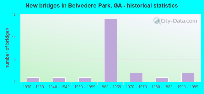
- New bridges - historical statistics
- 11930-1939
- 11940-1949
- 11950-1959
- 141960-1969
- 21970-1979
- 11980-1989
- 21990-1999

- Reconstructed bridges - Historical Statistics
- 11970-1979
- 21980-1989


- Bridge Condition - Deck
- 7.7%Very good
- 61.5%Good
- 23.1%Satisfactory
- 7.7%Fair

- Bridge Condition - Superstructure
- 7.7%Very good
- 69.2%Good
- 23.1%Satisfactory

- Bridge Condition - Substructure
- 7.7%Very good
- 69.2%Good
- 23.1%Satisfactory

- Bridge Condition - Channel
- 13.3%Very good
- 53.3%Good
- 13.3%Satisfactory
- 20.0%Fair

- Bridge Condition - Culverts
- 11.1%Very good
- 77.8%Good
- 11.1%Satisfactory
Find on map >> Show street view
Structure Number: 890015, Location: 6 MI SE OF DECATUR (Lat: 33.752578, Lng: -84.231789), Route carried "on" structure: US 278, Year Built: 1967, Status: Open, Structure Length: 9.51m (31.20ft), Average Daily Traffic: 32,930 (year 2011), Truck Traffic: 3%, Average Future Daily Traffic: 49,395 (year 2031), Design Load: HS 20+Mod, Features Intersected: I-285 (SR 407), Facility Carried by Structure: COVINGTON HIGHWAY
Minimum Vertical Clearance: 30+ m (98+ ft), Kilometerpoint: 3.219, Lanes on structure: 6, Lanes under structure: 8, Base Highway Network: Yes, Owner: State Highway Agency, Approaching Roadway Width: 19.5m (64.0ft), Skew: 4 degrees, Material/Design: Steel continuous, Design/Construction: Stringer/Multi-beam, Number Of Spans In Main Unit: 4, Length of Maximum Span: 28.0m (91.9ft), Curb or Sidewalk Widths: Left: 1.5m (4.9ft), Right: 1.5m (4.9ft), Curb-To-Curb Width: 19.5m (64.0ft), Out-to-Out Width: 22.6m (74.1ft)
Condition: Deck: Good, Superstructure: Satisfactory, Substructure: Satisfactory, Operating Rating: 30.8 metric tons, Method Used To Determine Operating Rating: Load Factor (LF), Inventory Rating: 18.1 metric tons, Method Used To Determine Inventory Rating: Load Factor (LF), Structural Evaluation: Meets minimum limits, Deck Geometry: High priority of replacement, Underclear: Meets minimum limits, Approach Roadway Alignment: Equal to present desirable criteria, Designated Inspection Frequency: Every 24 months, Inspection Date: May 2020, Other Special Inspection Date: April 2021, Bridge Improvement Cost: $2,549,000, Roadway Improvement Cost: $255,000, Total Project Cost: $3,823,000, Deck Structure Type: Concrete Cast-file-Place
Find on map >> Show street view
Structure Number: 890038, Location: 3.5 MI S OF DECATUR (Lat: 33.748036, Lng: -84.280936), Route carried "on" structure: State highway 154, Year Built: 1961, Status: Open, Structure Length: 1.01m (3.31ft), Average Daily Traffic: 18,740 (year 2011), Truck Traffic: 1%, Average Future Daily Traffic: 28,110 (year 2031), Design Load: HS 20+Mod, Features Intersected: SHOAL CREEK, Facility Carried by Structure: MEMORIAL DRIVE
Minimum Vertical Clearance: 30+ m (98+ ft), Kilometerpoint: 6.437, Lanes on structure: 5, Base Highway Network: Yes, Owner: State Highway Agency, Approaching Roadway Width: 15.8m (51.8ft), Skew: 1 degrees, Material/Design: Concrete, Design/Construction: Culvert, Number Of Spans In Main Unit: 3, Length of Maximum Span: 3.0m (9.8ft), Curb or Sidewalk Widths: Left: 1.5m (4.9ft), Right: 1.5m (4.9ft)
Condition: Channel: Fair, Culverts: Satisfactory, Operating Rating: 34.4 metric tons, Method Used To Determine Operating Rating: Load Factor (LF), Inventory Rating: 20.8 metric tons, Method Used To Determine Inventory Rating: Load Factor (LF), Structural Evaluation: Somewhat better than minimum adequacy, Waterway Adequacy: Equal to present minimum criteria, Approach Roadway Alignment: Equal to present desirable criteria, Designated Inspection Frequency: Every 24 months, Inspection Date: May 2020, Bridge Improvement Cost: $234,000, Roadway Improvement Cost: $23,000, Total Project Cost: $352,000
Find on map >> Show street view
Structure Number: 890051, Location: 3 MI SE OF DECATUR (Lat: 33.738250, Lng: -84.269606), Route carried "on" structure: State highway 260, Year Built: 1963, Status: Open, Structure Length: 1.52m (4.99ft), Average Daily Traffic: 14,060 (year 2011), Truck Traffic: 1%, Average Future Daily Traffic: 21,090 (year 2031), Design Load: HS 20+Mod, Features Intersected: SHOAL CREEK, Facility Carried by Structure: GLENWOOD AVE.
Minimum Vertical Clearance: 30+ m (98+ ft), Kilometerpoint: 8.047, Lanes on structure: 4, Base Highway Network: Yes, Owner: State Highway Agency, Approaching Roadway Width: 14.6m (47.9ft), Material/Design: Concrete, Design/Construction: Culvert, Number Of Spans In Main Unit: 5, Length of Maximum Span: 2.7m (8.9ft)
Condition: Channel: Fair, Culverts: Good, Operating Rating: 64.4 metric tons, Method Used To Determine Operating Rating: Load Factor (LF), Inventory Rating: 39.0 metric tons, Method Used To Determine Inventory Rating: Load Factor (LF), Structural Evaluation: Better than present minimum criteria, Waterway Adequacy: Equal to present minimum criteria, Approach Roadway Alignment: Equal to present desirable criteria, Designated Inspection Frequency: Every 24 months, Inspection Date: April 2020, Bridge Improvement Cost: $302,000, Roadway Improvement Cost: $30,000, Total Project Cost: $453,000
Find on map >> Show street view
Structure Number: 890052, Location: 5 MI SE OF DECATUR (Lat: 33.737689, Lng: -84.242997), Route carried "on" structure: State highway 260, Year Built: 1963, Status: Open, Structure Length: 1.37m (4.49ft), Average Daily Traffic: 20,030 (year 2011), Truck Traffic: 3%, Average Future Daily Traffic: 30,045 (year 2031), Design Load: HS 20+Mod, Features Intersected: COBB CREEK, Facility Carried by Structure: GLENWOOD ROAD
Minimum Vertical Clearance: 30+ m (98+ ft), Kilometerpoint: 9.656, Lanes on structure: 4, Base Highway Network: Yes, Owner: State Highway Agency, Approaching Roadway Width: 14.6m (47.9ft), Skew: 1 degrees, Material/Design: Concrete, Design/Construction: Culvert, Number Of Spans In Main Unit: 4, Length of Maximum Span: 3.4m (11.2ft)
Condition: Channel: Satisfactory, Culverts: Good, Inventory Rating: 80.7 metric tons, Method Used To Determine Inventory Rating: Load Factor (LF), Structural Evaluation: Better than present minimum criteria, Waterway Adequacy: Equal to present minimum criteria, Approach Roadway Alignment: Equal to present desirable criteria, Designated Inspection Frequency: Every 24 months, Inspection Date: May 2020, Bridge Improvement Cost: $272,000, Roadway Improvement Cost: $27,000, Total Project Cost: $408,000
Find on map >> Show street view
Structure Number: 890053, Location: 3.5 MI SE OF DECATUR (Lat: 33.737208, Lng: -84.230839), Route carried "on" structure: State highway 260, Year Built: 1966, Status: Open, Structure Length: 7.41m (24.31ft), Average Daily Traffic: 14,810 (year 2011), Truck Traffic: 1%, Average Future Daily Traffic: 22,215 (year 2031), Design Load: HS 20+Mod, Features Intersected: I-285 (SR 407), Facility Carried by Structure: GLENWOOD ROAD
Minimum Vertical Clearance: 30+ m (98+ ft), Kilometerpoint: 11.265, Lanes on structure: 5, Lanes under structure: 8, Base Highway Network: Yes, Owner: State Highway Agency, Approaching Roadway Width: 15.8m (51.8ft), Material/Design: Steel continuous, Design/Construction: Stringer/Multi-beam, Number Of Spans In Main Unit: 4, Length of Maximum Span: 21.3m (69.9ft), Curb or Sidewalk Widths: Left: 1.6m (5.2ft), Right: 1.6m (5.2ft), Curb-To-Curb Width: 15.8m (51.8ft), Out-to-Out Width: 19.7m (64.6ft)
Condition: Deck: Satisfactory, Superstructure: Satisfactory, Substructure: Satisfactory, Operating Rating: 34.4 metric tons, Method Used To Determine Operating Rating: Load Factor (LF), Inventory Rating: 20.8 metric tons, Method Used To Determine Inventory Rating: Load Factor (LF), Structural Evaluation: Somewhat better than minimum adequacy, Deck Geometry: High priority of replacement, Underclear: Meets minimum limits, Approach Roadway Alignment: Equal to present desirable criteria, Designated Inspection Frequency: Every 24 months, Inspection Date: May 2020, Bridge Improvement Cost: $1,726,000, Roadway Improvement Cost: $173,000, Total Project Cost: $2,589,000, Deck Structure Type: Concrete Cast-file-Place
Find on map >> Show street view
Structure Number: 890091, Location: 5.5 MI E OF DECATUR (Lat: 33.770869, Lng: -84.233256), Route carried "on" structure: Interstate 285, Year Built: 1966, Year Reconstructed: 1981, Status: Open, Structure Length: 4.39m (14.40ft), Average Daily Traffic: 173,270 (year 2011), Truck Traffic: 1%, Average Future Daily Traffic: 259,905 (year 2031), Design Load: HS 20+Mod, Features Intersected: M-9301 DURHAM PARK RD
Minimum Vertical Clearance: 30+ m (98+ ft), Kilometerpoint: 67.592, Lanes on structure: 8, Lanes under structure: 2, Base Highway Network: Yes, Owner: State Highway Agency, Approaching Roadway Width: 39.0m (128.0ft), Skew: 32 degrees, Material/Design: Steel, Design/Construction: Stringer/Multi-beam, Number Of Spans In Main Unit: 3, Length of Maximum Span: 21.9m (71.9ft), Curb-To-Curb Width: 39.0m (128.0ft), Out-to-Out Width: 41.0m (134.5ft)
Condition: Deck: Good, Superstructure: Good, Substructure: Good, Operating Rating: 38.1 metric tons, Method Used To Determine Operating Rating: Load Factor (LF), Inventory Rating: 22.6 metric tons, Method Used To Determine Inventory Rating: Load Factor (LF), Structural Evaluation: Somewhat better than minimum adequacy, Deck Geometry: Superior to present desirable criteria, Underclear: High priority of corrective action, Approach Roadway Alignment: Equal to present desirable criteria, Designated Inspection Frequency: Every 24 months, Inspection Date: May 2020, Bridge Improvement Cost: $1,483,000, Roadway Improvement Cost: $148,000, Total Project Cost: $2,225,000, Deck Structure Type: Concrete Cast-file-Place, Wearing Surface/Protective System: Wearing Surface: Epoxy Overlay
Find on map >> Show street view
Structure Number: 890115, Location: 6.5 MI SE OF DECATUR (Lat: 33.750658, Lng: -84.231539), Route carried "on" structure: County highway 519, Year Built: 1966, Status: Open, Structure Length: 9.72m (31.89ft), Average Daily Traffic: 2,202 (year 2011), Truck Traffic: 1%, Average Future Daily Traffic: 3,303 (year 2031), Design Load: HS 20+Mod, Features Intersected: I-285- 2 I-285 RAMPS, Facility Carried by Structure: REDWING C(3 X-REF)
Minimum Vertical Clearance: 30+ m (98+ ft), Kilometerpoint: 0.000, Lanes on structure: 2, Lanes under structure: 10, Base Highway Network: Yes, Owner: State Highway Agency, Approaching Roadway Width: 6.7m (22.0ft), Material/Design: Steel continuous, Design/Construction: Stringer/Multi-beam, Number Of Spans In Main Unit: 5, Length of Maximum Span: 29.0m (95.1ft), Curb or Sidewalk Widths: Left: 1.5m (4.9ft), Right: 1.5m (4.9ft), Curb-To-Curb Width: 8.5m (27.9ft), Out-to-Out Width: 11.9m (39.0ft)
Condition: Deck: Good, Superstructure: Good, Substructure: Good, Operating Rating: 46.2 metric tons, Method Used To Determine Operating Rating: Allowable Stress (AS), Inventory Rating: 32.6 metric tons, Method Used To Determine Inventory Rating: Allowable Stress (AS), Structural Evaluation: Better than present minimum criteria, Deck Geometry: Meets minimum limits, Underclear: Somewhat better than minimum adequacy, Approach Roadway Alignment: Equal to present desirable criteria, Designated Inspection Frequency: Every 24 months, Inspection Date: May 2020, Bridge Improvement Cost: $1,246,000, Roadway Improvement Cost: $125,000, Total Project Cost: $1,870,000, Deck Structure Type: Concrete Cast-file-Place
Find on map >> Show street view
Structure Number: 890186, Location: 3.2 MI SE OF DECATUR (Lat: 33.746358, Lng: -84.252208), Route carried "on" structure: City street 9233, Year Built: 1960, Status: Open, Structure Length: 0.85m (2.79ft), Average Daily Traffic: 4,810 (year 2011), Truck Traffic: 1%, Average Future Daily Traffic: 7,215 (year 2031), Design Load: H 15, Features Intersected: COBB CREEK, Facility Carried by Structure: PEACHCREST ROAD
Minimum Vertical Clearance: 30+ m (98+ ft), Kilometerpoint: 0.000, Lanes on structure: 2, Base Highway Network: Yes, Owner: County Highway Agency, Approaching Roadway Width: 9.1m (29.9ft), Material/Design: Concrete continuous, Design/Construction: Slab, Number Of Spans In Main Unit: 2, Length of Maximum Span: 4.3m (14.1ft), Curb or Sidewalk Widths: Left: 1.9m (6.2ft), Right: 1.9m (6.2ft), Curb-To-Curb Width: 9.2m (30.2ft), Out-to-Out Width: 13.4m (44.0ft)
Condition: Deck: Good, Superstructure: Good, Substructure: Good, Channel: Good, Operating Rating: 32.6 metric tons, Method Used To Determine Operating Rating: Allowable Stress (AS), Inventory Rating: 23.5 metric tons, Method Used To Determine Inventory Rating: Allowable Stress (AS), Structural Evaluation: Equal to present minimum criteria, Deck Geometry: Meets minimum limits, Waterway Adequacy: Equal to present desirable criteria, Approach Roadway Alignment: Equal to present desirable criteria, Designated Inspection Frequency: Every 24 months, Inspection Date: May 2020, Bridge Improvement Cost: $109,000, Roadway Improvement Cost: $11,000, Total Project Cost: $164,000, Deck Structure Type: Concrete Cast-file-Place
Find on map >> Show street view
Structure Number: 890188, Location: 5.5 MI E OF DECATUR (Lat: 33.763750, Lng: -84.232389), Route carried "on" structure: City street 9235, Year Built: 1966, Status: Open, Structure Length: 7.04m (23.10ft), Average Daily Traffic: 16,070 (year 2011), Truck Traffic: 1%, Average Future Daily Traffic: 24,105 (year 2031), Design Load: HS 20+Mod, Features Intersected: I-285 (SR 407), Facility Carried by Structure: REDAN ROAD
Minimum Vertical Clearance: 30+ m (98+ ft), Kilometerpoint: 3.219, Lanes on structure: 2, Lanes under structure: 8, Base Highway Network: Yes, Owner: State Highway Agency, Approaching Roadway Width: 7.9m (25.9ft), Material/Design: Steel continuous, Design/Construction: Stringer/Multi-beam, Number Of Spans In Main Unit: 4, Length of Maximum Span: 21.0m (68.9ft), Curb or Sidewalk Widths: Left: 1.6m (5.2ft), Right: 0.8m (2.6ft), Curb-To-Curb Width: 8.5m (27.9ft), Out-to-Out Width: 11.5m (37.7ft)
Condition: Deck: Good, Superstructure: Good, Substructure: Good, Operating Rating: 46.2 metric tons, Method Used To Determine Operating Rating: Allowable Stress (AS), Inventory Rating: 32.6 metric tons, Method Used To Determine Inventory Rating: Allowable Stress (AS), Structural Evaluation: Better than present minimum criteria, Deck Geometry: Meets minimum limits, Underclear: Meets minimum limits, Approach Roadway Alignment: Equal to present minimum criteria, Length Of Structure Improvement: 47.37m (155.41ft), Designated Inspection Frequency: Every 24 months, Inspection Date: May 2020, Bridge Improvement Cost: $903,000, Roadway Improvement Cost: $90,000, Total Project Cost: $1,354,000, Deck Structure Type: Concrete Cast-file-Place
Find on map >> Show street view
Structure Number: 890189, Location: 3.4 MI SE OF CLARKSTON (Lat: 33.763339, Lng: -84.220389), Route carried "on" structure: City street 9235, Year Built: 1940, Year Reconstructed: 1992, Status: Open, Structure Length: 2.74m (8.99ft), Average Daily Traffic: 15,720 (year 2011), Truck Traffic: 3%, Average Future Daily Traffic: 23,580 (year 2031), Design Load: H 15, Features Intersected: SNAPFINGER CREEK, Facility Carried by Structure: REDAN ROAD
Minimum Vertical Clearance: 30+ m (98+ ft), Kilometerpoint: 6.437, Lanes on structure: 5, Base Highway Network: Yes, Owner: County Highway Agency, Approaching Roadway Width: 7.3m (24.0ft), Material/Design: Steel, Design/Construction: Stringer/Multi-beam, Number Of Spans In Main Unit: 3, Length of Maximum Span: 9.1m (29.9ft), Curb or Sidewalk Widths: Left: 1.8m (5.9ft), Right: 1.8m (5.9ft), Curb-To-Curb Width: 19.5m (64.0ft), Out-to-Out Width: 23.9m (78.4ft)
Condition: Deck: Good, Superstructure: Good, Substructure: Good, Channel: Good, Operating Rating: 38.1 metric tons, Method Used To Determine Operating Rating: Load Factor (LF), Inventory Rating: 22.6 metric tons, Method Used To Determine Inventory Rating: Load Factor (LF), Structural Evaluation: Somewhat better than minimum adequacy, Deck Geometry: Meets minimum limits, Waterway Adequacy: Equal to present desirable criteria, Approach Roadway Alignment: Equal to present desirable criteria, Length Of Structure Improvement: 42.98m (141.01ft), Designated Inspection Frequency: Every 24 months, Inspection Date: May 2020, Bridge Improvement Cost: $639,000, Roadway Improvement Cost: $64,000, Total Project Cost: $959,000, Deck Structure Type: Concrete Cast-file-Place
Find on map >> Show street view
Structure Number: 890219, Location: 4 MI SE OF CLARKSTON (Lat: 33.754356, Lng: -84.220564), Route carried "on" structure: City street 9300, Year Built: 1960, Status: Open, Structure Length: 0.67m (2.20ft), Average Daily Traffic: 13,770 (year 2011), Truck Traffic: 2%, Average Future Daily Traffic: 20,655 (year 2031), Design Load: H 15, Features Intersected: SNAPFINGER CREEK TRIB, Facility Carried by Structure: INDIAN CREEK ROAD
Minimum Vertical Clearance: 30+ m (98+ ft), Kilometerpoint: 1.609, Lanes on structure: 2, Base Highway Network: Yes, Owner: City or Municipal Highway Agency, Approaching Roadway Width: 7.9m (25.9ft), Skew: 3 degrees, Material/Design: Concrete, Design/Construction: Culvert, Number Of Spans In Main Unit: 2, Length of Maximum Span: 3.0m (9.8ft)
Condition: Channel: Very good, Culverts: Good, Operating Rating: 43.5 metric tons, Method Used To Determine Operating Rating: Field evaluation and documented engineering judgment, Inventory Rating: 24.4 metric tons, Method Used To Determine Inventory Rating: Field evaluation and documented engineering judgment, Structural Evaluation: Equal to present minimum criteria, Waterway Adequacy: Equal to present desirable criteria, Approach Roadway Alignment: Equal to present minimum criteria, Designated Inspection Frequency: Every 24 months, Inspection Date: May 2020, Bridge Improvement Cost: $86,000, Roadway Improvement Cost: $9,000, Total Project Cost: $129,000
Find on map >> Show street view
Structure Number: 89022, Location: 2.8 MI S OF CLARKSTON (Lat: 33.768439, Lng: -84.224728), Route carried "on" structure: City street 9300, Year Built: 1935, Year Reconstructed: 1992, Status: Open, Structure Length: 1.13m (3.71ft), Average Daily Traffic: 13,770 (year 2011), Truck Traffic: 2%, Average Future Daily Traffic: 20,655 (year 2031), Design Load: H 15, Features Intersected: INDIAN CREEK, Facility Carried by Structure: INDIAN CREEK ROAD
Minimum Vertical Clearance: 30+ m (98+ ft), Kilometerpoint: 3.219, Lanes on structure: 3, Base Highway Network: Yes, Owner: County Highway Agency, Approaching Roadway Width: 12.2m (40.0ft), Skew: 9 degrees, Material/Design: Concrete, Design/Construction: Tee Beam, Number Of Spans In Main Unit: 1, Length of Maximum Span: 11.3m (37.1ft), Curb or Sidewalk Widths: Left: 1.8m (5.9ft), Right: 1.8m (5.9ft), Curb-To-Curb Width: 12.4m (40.7ft), Out-to-Out Width: 16.7m (54.8ft)
Condition: Deck: Satisfactory, Superstructure: Good, Substructure: Satisfactory, Channel: Good, Operating Rating: 38.1 metric tons, Method Used To Determine Operating Rating: Allowable Stress (AS), Inventory Rating: 19.0 metric tons, Method Used To Determine Inventory Rating: Allowable Stress (AS), Structural Evaluation: Meets minimum limits, Deck Geometry: Meets minimum limits, Waterway Adequacy: Equal to present desirable criteria, Approach Roadway Alignment: Equal to present desirable criteria, Length Of Structure Improvement: 8.38m (27.49ft), Designated Inspection Frequency: Every 24 months, Inspection Date: May 2020, Bridge Improvement Cost: $184,000, Roadway Improvement Cost: $18,000, Total Project Cost: $276,000, Deck Structure Type: Concrete Cast-file-Place, Wearing Surface/Protective System: Wearing Surface: Bituminous
Find on map >> Show street view
Structure Number: 890221, Location: 2.7 MI S OF CLARKSTON (Lat: 33.770919, Lng: -84.229339), Route carried "on" structure: City street 9301, Year Built: 1979, Status: Open, Structure Length: 1.34m (4.40ft), Average Daily Traffic: 5,020 (year 2011), Truck Traffic: 1%, Average Future Daily Traffic: 7,530 (year 2031), Design Load: HS 20+Mod, Features Intersected: INDIAN CREEK, Facility Carried by Structure: DURHAM PARK ROAD
Minimum Vertical Clearance: 30+ m (98+ ft), Kilometerpoint: 0.000, Lanes on structure: 2, Base Highway Network: Yes, Owner: City or Municipal Highway Agency, Approaching Roadway Width: 7.0m (23.0ft), Skew: 1 degrees, Material/Design: Concrete, Design/Construction: Culvert, Number Of Spans In Main Unit: 4, Length of Maximum Span: 3.0m (9.8ft)
Condition: Channel: Good, Culverts: Good, Operating Rating: 43.5 metric tons, Method Used To Determine Operating Rating: Field evaluation and documented engineering judgment, Inventory Rating: 24.4 metric tons, Method Used To Determine Inventory Rating: Field evaluation and documented engineering judgment, Structural Evaluation: Equal to present minimum criteria, Waterway Adequacy: Equal to present desirable criteria, Approach Roadway Alignment: Equal to present desirable criteria, Designated Inspection Frequency: Every 24 months, Inspection Date: May 2020, Bridge Improvement Cost: $172,000, Roadway Improvement Cost: $17,000, Total Project Cost: $258,000
Find on map >> Show street view
Structure Number: 890222, Location: 3.1 MI SE OF CLARKSTON (Lat: 33.767269, Lng: -84.223369), Route carried "on" structure: City street 9303, Year Built: 1963, Status: Open, Structure Length: 2.96m (9.71ft), Average Daily Traffic: 6,550 (year 2011), Truck Traffic: 1%, Average Future Daily Traffic: 9,825 (year 2031), Design Load: H 15, Features Intersected: INDIAN CREEK, Facility Carried by Structure: ROWLAND ROAD
Minimum Vertical Clearance: 30+ m (98+ ft), Kilometerpoint: 0.000, Lanes on structure: 2, Base Highway Network: Yes, Owner: County Highway Agency, Approaching Roadway Width: 8.5m (27.9ft), Material/Design: Concrete, Design/Construction: Tee Beam, Number Of Spans In Main Unit: 3, Length of Maximum Span: 10.1m (33.1ft), Curb or Sidewalk Widths: Left: 0.6m (2.0ft), Right: 0.6m (2.0ft), Curb-To-Curb Width: 8.5m (27.9ft), Out-to-Out Width: 10.5m (34.4ft)
Condition: Deck: Satisfactory, Superstructure: Good, Substructure: Good, Channel: Good, Operating Rating: 35.3 metric tons, Method Used To Determine Operating Rating: Allowable Stress (AS), Inventory Rating: 21.7 metric tons, Method Used To Determine Inventory Rating: Allowable Stress (AS), Structural Evaluation: Somewhat better than minimum adequacy, Deck Geometry: High priority of replacement, Waterway Adequacy: Equal to present desirable criteria, Approach Roadway Alignment: Equal to present desirable criteria, Length Of Structure Improvement: 43.22m (141.80ft), Designated Inspection Frequency: Every 24 months, Inspection Date: May 2020, Bridge Improvement Cost: $379,000, Roadway Improvement Cost: $38,000, Total Project Cost: $568,000, Deck Structure Type: Concrete Cast-file-Place
Find on map >> Show street view
Structure Number: 890312, Location: 5.5 MI E OF DECATUR (Lat: 33.769447, Lng: -84.232781), Route carried "on" structure: Ramp Interstate 285, Year Built: 1992, Status: Open, Structure Length: 10.21m (33.50ft), Average Daily Traffic: 173,270 (year 2011), Truck Traffic: 1%, Average Future Daily Traffic: 259,905 (year 2031), Design Load: HS 20+Mod, Features Intersected: I-285 (SR 407)
Minimum Vertical Clearance: 30+ m (98+ ft), Kilometerpoint: 67.592, Lanes on structure: 1, Lanes under structure: 8, Base Highway Network: Yes, Owner: State Highway Agency, Approaching Roadway Width: 8.5m (27.9ft), Material/Design: Steel continuous, Design/Construction: Stringer/Multi-beam, Number Of Spans In Main Unit: 2, Length of Maximum Span: 55.5m (182.1ft), Curb-To-Curb Width: 9.8m (32.2ft), Out-to-Out Width: 10.7m (35.1ft)
Condition: Deck: Good, Superstructure: Good, Substructure: Good, Operating Rating: 89.8 metric tons, Method Used To Determine Operating Rating: Load Factor (LF), Inventory Rating: 54.4 metric tons, Method Used To Determine Inventory Rating: Load Factor (LF), Structural Evaluation: Better than present minimum criteria, Deck Geometry: Superior to present desirable criteria, Underclear: Somewhat better than minimum adequacy, Approach Roadway Alignment: Equal to present desirable criteria, Designated Inspection Frequency: Every 24 months, Inspection Date: May 2020, Bridge Improvement Cost: $952,000, Roadway Improvement Cost: $95,000, Total Project Cost: $1,428,000, Deck Structure Type: Concrete Cast-file-Place
Find on map >> Show street view
Structure Number: 895006, Location: 1 MI SE OF DECATUR (Lat: 33.742378, Lng: -84.269978), Route carried "on" structure: County highway 277, Year Built: 1962, Status: Open, Structure Length: 1.25m (4.10ft), Average Daily Traffic: 2,202 (year 2011), Truck Traffic: 1%, Average Future Daily Traffic: 3,303 (year 2031), Design Load: H 15, Features Intersected: SHOAL CREEK, Facility Carried by Structure: WHITEOAK DRIVE
Minimum Vertical Clearance: 30+ m (98+ ft), Kilometerpoint: 0.000, Lanes on structure: 2, Base Highway Network: Yes, Owner: County Highway Agency, Approaching Roadway Width: 7.9m (25.9ft), Skew: 4 degrees, Material/Design: Concrete, Design/Construction: Culvert, Number Of Spans In Main Unit: 3, Length of Maximum Span: 4.0m (13.1ft), Curb or Sidewalk Widths: Left: 2.4m (7.9ft), Right: 0.0m
Condition: Channel: Satisfactory, Culverts: Good, Operating Rating: 43.5 metric tons, Method Used To Determine Operating Rating: Field evaluation and documented engineering judgment, Inventory Rating: 24.4 metric tons, Method Used To Determine Inventory Rating: Field evaluation and documented engineering judgment, Structural Evaluation: Equal to present minimum criteria, Waterway Adequacy: Equal to present desirable criteria, Approach Roadway Alignment: Equal to present minimum criteria, Designated Inspection Frequency: Every 24 months, Inspection Date: May 2020, Bridge Improvement Cost: $160,000, Roadway Improvement Cost: $16,000, Total Project Cost: $240,000
Find on map >> Show street view
Structure Number: 895007, Location: SE CORNER OF DECATUR (Lat: 33.750158, Lng: -84.282258), Route carried "on" structure: County highway 327, Year Built: 1981, Status: Open, Structure Length: 1.13m (3.71ft), Average Daily Traffic: 2,202 (year 2011), Truck Traffic: 1%, Average Future Daily Traffic: 3,303 (year 2031), Design Load: HS 20, Features Intersected: SHOAL CREEK, Facility Carried by Structure: OLDFIELD ROAD
Minimum Vertical Clearance: 30+ m (98+ ft), Kilometerpoint: 1.609, Lanes on structure: 2, Base Highway Network: Yes, Owner: County Highway Agency, Approaching Roadway Width: 6.7m (22.0ft), Skew: 3 degrees, Material/Design: Concrete, Design/Construction: Culvert, Number Of Spans In Main Unit: 3, Length of Maximum Span: 3.7m (12.1ft)
Condition: Channel: Good, Culverts: Good, Operating Rating: 55.3 metric tons, Method Used To Determine Operating Rating: Field evaluation and documented engineering judgment, Inventory Rating: 32.6 metric tons, Method Used To Determine Inventory Rating: Field evaluation and documented engineering judgment, Structural Evaluation: Better than present minimum criteria, Waterway Adequacy: Equal to present desirable criteria, Approach Roadway Alignment: Equal to present minimum criteria, Designated Inspection Frequency: Every 24 months, Inspection Date: May 2020, Bridge Improvement Cost: $145,000, Roadway Improvement Cost: $14,000, Total Project Cost: $217,000
Find on map >> Show street view
Structure Number: 895009, Location: 2 MI SE OF DECATUR (Lat: 33.748150, Lng: -84.254389), Route carried "on" structure: County highway 503, Year Built: 1964, Status: Open, Structure Length: 0.91m (2.99ft), Average Daily Traffic: 2,202 (year 2011), Truck Traffic: 1%, Average Future Daily Traffic: 3,303 (year 2031), Design Load: H 15, Features Intersected: COBB CREEK, Facility Carried by Structure: ALVERADO WAY
Minimum Vertical Clearance: 30+ m (98+ ft), Kilometerpoint: 0.000, Lanes on structure: 2, Base Highway Network: Yes, Owner: County Highway Agency, Approaching Roadway Width: 9.1m (29.9ft), Material/Design: Concrete, Design/Construction: Slab, Number Of Spans In Main Unit: 2, Length of Maximum Span: 4.6m (15.1ft), Curb or Sidewalk Widths: Left: 2.1m (6.9ft), Right: 2.1m (6.9ft), Curb-To-Curb Width: 9.1m (29.9ft), Out-to-Out Width: 13.5m (44.3ft)
Condition: Deck: Good, Superstructure: Good, Substructure: Good, Channel: Good, Operating Rating: 32.6 metric tons, Method Used To Determine Operating Rating: Load Factor (LF), Inventory Rating: 24.4 metric tons, Method Used To Determine Inventory Rating: Load Factor (LF), Structural Evaluation: Equal to present minimum criteria, Deck Geometry: Meets minimum limits, Waterway Adequacy: Equal to present desirable criteria, Approach Roadway Alignment: Equal to present desirable criteria, Designated Inspection Frequency: Every 24 months, Inspection Date: May 2020, Bridge Improvement Cost: $117,000, Roadway Improvement Cost: $12,000, Total Project Cost: $176,000, Deck Structure Type: Concrete Cast-file-Place
Find on map >> Show street view
Structure Number: 895062, Location: 2 MI SE OF DECATUR (Lat: 33.746828, Lng: -84.280239), Route carried "on" structure: County highway 2517, Year Built: 1965, Status: Open, Structure Length: 0.98m (3.22ft), Average Daily Traffic: 2,202 (year 2011), Truck Traffic: 1%, Average Future Daily Traffic: 3,303 (year 2031), Design Load: HS 20+Mod, Features Intersected: SHOAL CREEK, Facility Carried by Structure: LINE STREET
Minimum Vertical Clearance: 30+ m (98+ ft), Kilometerpoint: 0.000, Lanes on structure: 2, Base Highway Network: Yes, Owner: County Highway Agency, Approaching Roadway Width: 8.8m (28.9ft), Material/Design: Concrete, Design/Construction: Culvert, Number Of Spans In Main Unit: 3, Length of Maximum Span: 3.0m (9.8ft), Curb or Sidewalk Widths: Left: 1.7m (5.6ft), Right: 0.0m
Condition: Channel: Very good, Culverts: Good, Operating Rating: 55.3 metric tons, Method Used To Determine Operating Rating: Field evaluation and documented engineering judgment, Inventory Rating: 32.6 metric tons, Method Used To Determine Inventory Rating: Field evaluation and documented engineering judgment, Structural Evaluation: Better than present minimum criteria, Waterway Adequacy: Equal to present desirable criteria, Approach Roadway Alignment: Equal to present desirable criteria, Designated Inspection Frequency: Every 24 months, Inspection Date: May 2020, Bridge Improvement Cost: $125,000, Roadway Improvement Cost: $13,000, Total Project Cost: $188,000
Find on map >> Show street view
Structure Number: 895122, Location: 3.5 MI SE OF DECATUR (Lat: 33.744119, Lng: -84.249419), Route carried "on" structure: City street 4585, Year Built: 1975, Status: Open, Structure Length: 0.98m (3.22ft), Average Daily Traffic: 2,202 (year 2011), Truck Traffic: 1%, Average Future Daily Traffic: 3,303 (year 2031), Design Load: H 15, Features Intersected: COBB CREEK, Facility Carried by Structure: COBBS FERRY
Minimum Vertical Clearance: 30+ m (98+ ft), Kilometerpoint: 0.000, Lanes on structure: 2, Base Highway Network: Yes, Owner: County Highway Agency, Approaching Roadway Width: 7.9m (25.9ft), Skew: 2 degrees, Material/Design: Steel, Design/Construction: Culvert, Number Of Spans In Main Unit: 2, Length of Maximum Span: 4.6m (15.1ft)
Condition: Channel: Good, Culverts: Very good, Operating Rating: 43.5 metric tons, Method Used To Determine Operating Rating: Field evaluation and documented engineering judgment, Inventory Rating: 24.4 metric tons, Method Used To Determine Inventory Rating: Field evaluation and documented engineering judgment, Structural Evaluation: Equal to present minimum criteria, Waterway Adequacy: Better than present minimum criteria, Approach Roadway Alignment: Equal to present minimum criteria, Designated Inspection Frequency: Every 24 months, Inspection Date: May 2020, Bridge Improvement Cost: $125,000, Roadway Improvement Cost: $13,000, Total Project Cost: $188,000
Find on map >> Show street view
Structure Number: 895133, Location: 0.2 MI S OF AVONDALE (Lat: 33.770139, Lng: -84.236089), Route carried "on" structure: City street 9235, Year Built: 1991, Status: Open, Structure Length: 0.94m (3.08ft), Average Daily Traffic: 15,960 (year 2012), Truck Traffic: 1%, Average Future Daily Traffic: 23,940 (year 2032), Design Load: HS 20+Mod, Features Intersected: MARTA, Facility Carried by Structure: KENSINGTON ROAD
Minimum Vertical Clearance: 30+ m (98+ ft), Kilometerpoint: 1.609, Lanes on structure: 2, Base Highway Network: Yes, Owner: Private, Approaching Roadway Width: 6.7m (22.0ft), Skew: 5 degrees, Material/Design: Concrete, Design/Construction: Frame, Number Of Spans In Main Unit: 2, Length of Maximum Span: 4.6m (15.1ft), Curb-To-Curb Width: 8.4m (27.6ft), Out-to-Out Width: 50.0m (164.0ft)
Condition: Deck: Very good, Superstructure: Very good, Substructure: Very good, Operating Rating: 54.4 metric tons, Method Used To Determine Operating Rating: Field evaluation and documented engineering judgment, Inventory Rating: 32.6 metric tons, Method Used To Determine Inventory Rating: Field evaluation and documented engineering judgment, Structural Evaluation: Equal to present desirable criteria, Deck Geometry: High priority of replacement, Underclear: High priority of corrective action, Approach Roadway Alignment: Equal to present desirable criteria, Designated Inspection Frequency: Every 24 months, Inspection Date: April 2020, Bridge Improvement Cost: $121,000, Roadway Improvement Cost: $12,000, Total Project Cost: $182,000, Deck Structure Type: Concrete Cast-file-Place, Wearing Surface/Protective System: Wearing Surface: Bituminous
Find on map >> Show street view
Structure Number: 895153, Location: 3MI E OF DECATUR (Lat: 33.770278, Lng: -84.223839), Route carried "on" structure: County highway 5722, Year Built: 1950, Status: Open, Structure Length: 0.82m (2.69ft), Average Daily Traffic: 2,202 (year 2011), Truck Traffic: 1%, Average Future Daily Traffic: 3,303 (year 2031), Design Load: H 10, Features Intersected: SNAPFINGER CREEK, Facility Carried by Structure: PARK DRIVE
Minimum Vertical Clearance: 30+ m (98+ ft), Kilometerpoint: 0.000, Lanes on structure: 1, Base Highway Network: Yes, Owner: County Highway Agency, Approaching Roadway Width: 3.0m (9.8ft), Material/Design: Steel, Design/Construction: Stringer/Multi-beam, Number Of Spans In Main Unit: 1, Length of Maximum Span: 8.2m (26.9ft), Curb-To-Curb Width: 3.6m (11.8ft), Out-to-Out Width: 4.1m (13.5ft)
Condition: Deck: Fair, Superstructure: Satisfactory, Substructure: Good, Channel: Fair, Operating Rating: 39.9 metric tons, Method Used To Determine Operating Rating: Load Factor (LF), Inventory Rating: 24.4 metric tons, Method Used To Determine Inventory Rating: Load Factor (LF), Structural Evaluation: Equal to present minimum criteria, Deck Geometry: High priority of replacement, Waterway Adequacy: Equal to present minimum criteria, Approach Roadway Alignment: Equal to present minimum criteria, Length Of Structure Improvement: 0.82m (2.69ft), Designated Inspection Frequency: Every 24 months, Inspection Date: May 2020, Bridge Improvement Cost: $77,000, Roadway Improvement Cost: $8,000, Total Project Cost: $115,000, Deck Structure Type: Wood or Timber, Wearing Surface/Protective System: Wearing Surface: Wood or Timber
Find on map >> Show street view
Structure Number: 890015, Location: 6 MI SE OF DECATUR (Lat: 33.752578, Lng: -84.231789), Route carried "under" structure: Interstate 285, Structure Length: 0. m, Average Daily Traffic: 173,700 (year 1999), Truck Traffic: 1%, Features Intersected: SR 12 COVINGTON HIGHWAY, Facility Carried by Structure: COVINGTON HIGHWAY
Minimum Vertical Clearance: 5.20m (17.06ft), Kilometerpoint: 69.202, Lanes on structure: 6, Length of Maximum Span: 0.0m
Find on map >> Show street view
Structure Number: 890053, Location: 3.5 MI SE OF DECATUR (Lat: 33.737208, Lng: -84.230839), Route carried "under" structure: Interstate 285, Structure Length: 0. m, Average Daily Traffic: 173,600 (year 1999), Truck Traffic: 1%, Features Intersected: SR 260 GLENWOOD ROAD, Facility Carried by Structure: GLENWOOD ROAD
Minimum Vertical Clearance: 5.99m (19.65ft), Kilometerpoint: 70.811, Lanes on structure: 5, Length of Maximum Span: 0.0m
Find on map >> Show street view
Structure Number: 890091, Location: 5.5 MI E OF DECATUR (Lat: 33.770869, Lng: -84.233256), Route carried "under" structure: City street 9301, Structure Length: 0. m, Average Daily Traffic: 11,840 (year 1999), Truck Traffic: 1%, Features Intersected: I-285 (SR 407), Facility Carried by Structure: I-285
Minimum Vertical Clearance: 4.08m (13.39ft), Kilometerpoint: 0.000, Lanes on structure: 8, Length of Maximum Span: 0.0m
Find on map >> Show street view
Structure Number: 890115, Location: 6.5 MI SE OF DECATUR (Lat: 33.750658, Lng: -84.231539), Route carried "under" structure: Interstate 285, Structure Length: 0. m, Average Daily Traffic: 173,700 (year 1999), Truck Traffic: 1%, Features Intersected: CR 519 REDWING CIRCLE, Facility Carried by Structure: REDWING C(3 X-REF)
Minimum Vertical Clearance: 5.61m (18.41ft), Kilometerpoint: 69.202, Lanes on structure: 2, Length of Maximum Span: 0.0m
Find on map >> Show street view
Structure Number: 890115, Location: 6.5 MI SE OF DECATUR (Lat: 33.750658, Lng: -84.231539), Route carried "under" structure: Ramp Interstate 285, Structure Length: 0. m, Average Daily Traffic: 3,002 (year 1996), Truck Traffic: 1%, Features Intersected: CR 519 REDWING CIRCLE, Facility Carried by Structure: REDWING C(3 X-REF)
Minimum Vertical Clearance: 5.15m (16.90ft), Kilometerpoint: 69.202, Lanes on structure: 2, Length of Maximum Span: 0.0m
Find on map >> Show street view
Structure Number: 890115, Location: 6.5 MI SE OF DECATUR (Lat: 33.750658, Lng: -84.231539), Route carried "under" structure: Ramp Interstate 285, Structure Length: 0. m, Average Daily Traffic: 3,002 (year 1996), Truck Traffic: 1%, Features Intersected: CR 519 REDWING CIRCLE, Facility Carried by Structure: REDWING C(3 X-REF)
Minimum Vertical Clearance: 5.58m (18.31ft), Kilometerpoint: 69.202, Lanes on structure: 2, Length of Maximum Span: 0.0m
Find on map >> Show street view
Structure Number: 890188, Location: 5.5 MI E OF DECATUR (Lat: 33.763750, Lng: -84.232389), Route carried "under" structure: Interstate 285, Structure Length: 0. m, Average Daily Traffic: 177,500 (year 1999), Truck Traffic: 1%, Features Intersected: M-9235 REDAN ROAD, Facility Carried by Structure: REDAN ROAD
Minimum Vertical Clearance: 5.20m (17.06ft), Kilometerpoint: 67.592, Lanes on structure: 2, Length of Maximum Span: 0.0m
Find on map >> Show street view
Structure Number: 890312, Location: 5.5 MI E OF DECATUR (Lat: 33.769447, Lng: -84.232781), Route carried "under" structure: Interstate 285, Structure Length: 0. m, Average Daily Traffic: 177,500 (year 1999), Truck Traffic: 1%, Features Intersected: RAMP TO MARTA PARKING
Minimum Vertical Clearance: 7.62m (25.00ft), Kilometerpoint: 67.592, Lanes on structure: 1, Length of Maximum Span: 0.0m