Bridge Statistics for Bedford Heights, Ohio (OH)
Condition, Traffic, Stress, Structural Evaluation, Project Costs
- National Bridge Inventory (NBI) Statistics
- 33Number of bridges
- 604ft / 184mTotal length
- $19,881,000Total costs
- 924,070Total average daily traffic
- 91,527Total average daily truck traffic
- National Bridge Inventory (NBI) Registered Bridges for Bedford Heights
- No street view available for this location
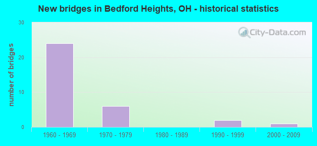
- New bridges - historical statistics
- 241960-1969
- 61970-1979
- 21990-1999
- 12000-2009

- Reconstructed bridges - Historical Statistics
- 11980-1989
- 81990-1999
- 52000-2009


- Bridge Condition - Deck
- 10.0%Excellent
- 25.0%Very good
- 30.0%Good
- 20.0%Satisfactory
- 15.0%Fair

- Bridge Condition - Superstructure
- 25.0%Excellent
- 10.0%Very good
- 40.0%Good
- 15.0%Satisfactory
- 10.0%Fair

- Bridge Condition - Substructure
- 10.0%Excellent
- 25.0%Very good
- 40.0%Good
- 15.0%Satisfactory
- 10.0%Fair

- Bridge Condition - Channel
- 33.3%Very good
- 33.3%Good
- 16.7%Satisfactory
- 16.7%Fair
Find on map >> Show street view
Structure Number: 1632183, Location: 0.2 MI SOUTH OF SR 60 (Lat: 40.297381, Lng: -82.005739), Route carried "on" structure: County highway T0078, Year Built: 2009, Status: Open, Structure Length: 1.10m (3.61ft), Average Daily Traffic: 96 (year 2015), Truck Traffic: 7%, Average Future Daily Traffic: 133 (year 2035), Design Load: HS 20, Features Intersected: SIMMONS RUN, Facility Carried by Structure: TOWNSHIP ROAD 78
Minimum Vertical Clearance: 30+ m (98+ ft), Kilometerpoint: 0.016, Lanes on structure: 1, Owner: County Highway Agency, Approaching Roadway Width: 6.1m (20.0ft), Material/Design: Prestressed concrete, Design/Construction: Box Beam or Girders - Multiple, Number Of Spans In Main Unit: 1, Length of Maximum Span: 10.4m (34.1ft), Curb-To-Curb Width: 7.3m (24.0ft), Out-to-Out Width: 7.3m (24.0ft)
Condition: Deck: Very good, Superstructure: Very good, Substructure: Very good, Channel: Satisfactory, Operating Rating: 74.5 metric tons, Method Used To Determine Operating Rating: Load Factor (LF) rating reported by rating factor (RF) method using MS18 loading, Inventory Rating: 45.4 metric tons, Method Used To Determine Inventory Rating: Load Factor (LF) rating reported by rating factor (RF) method using MS18 loading, Structural Evaluation: Equal to present desirable criteria, Deck Geometry: Equal to present minimum criteria, Waterway Adequacy: Equal to present desirable criteria, Approach Roadway Alignment: Equal to present desirable criteria, Designated Inspection Frequency: Every 24 months, Inspection Date: April 2021, Deck Structure Type: Concrete Cast-file-Place, Wearing Surface/Protective System: Wearing Surface: Bituminous, Deck Protection: Other
Find on map >> Show street view
Structure Number: 1632442, Location: 0.1 mile E jct CR12 (Lat: 40.367569, Lng: -81.855631), Route carried "on" structure: County highway T0206, Year Built: 1970, Year Reconstructed: 1996, Status: Open, Structure Length: 1.25m (4.10ft), Average Daily Traffic: 351 (year 2015), Truck Traffic: 7%, Average Future Daily Traffic: 487 (year 2035), Features Intersected: MILL CREEK, Facility Carried by Structure: TOWNSHIP ROAD 206
Minimum Vertical Clearance: 30+ m (98+ ft), Kilometerpoint: 0.016, Lanes on structure: 1, Owner: County Highway Agency, Approaching Roadway Width: 4.0m (13.1ft), Material/Design: Steel, Design/Construction: Stringer/Multi-beam, Number Of Spans In Main Unit: 1, Length of Maximum Span: 12.5m (41.0ft), Curb-To-Curb Width: 4.9m (16.1ft), Out-to-Out Width: 5.4m (17.7ft)
Condition: Deck: Fair, Superstructure: Fair, Substructure: Fair, Channel: Fair, Operating Rating: 87.5 metric tons, Method Used To Determine Operating Rating: Load Factor (LF) rating reported by rating factor (RF) method using MS18 loading, Inventory Rating: 51.8 metric tons, Method Used To Determine Inventory Rating: Load Factor (LF) rating reported by rating factor (RF) method using MS18 loading, Structural Evaluation: Somewhat better than minimum adequacy, Deck Geometry: High priority of replacement, Waterway Adequacy: Meets minimum limits, Approach Roadway Alignment: Equal to present desirable criteria, Designated Inspection Frequency: Every 12 months, Inspection Date: April 2021, Deck Structure Type: Wood or Timber
Find on map >> Show street view
Structure Number: 1802747, Location: 0.35 MI. EAST OF JCT SR 8 (Lat: 41.416989, Lng: -81.520589), Route carried "on" structure: State highway 17, Year Built: 1993, Status: Open, Structure Length: 0.82m (2.69ft), Average Daily Traffic: 9,037 (year 2015), Truck Traffic: 8%, Average Future Daily Traffic: 12,543 (year 2035), Design Load: HS 20+Mod, Features Intersected: BEAR CRK .21 MI W OF 480
Minimum Vertical Clearance: 30+ m (98+ ft), Kilometerpoint: 33.555, Lanes on structure: 4, Owner: State Highway Agency, Approaching Roadway Width: 15.9m (52.2ft), Skew: 1 degrees, Material/Design: Concrete, Design/Construction: Slab, Number Of Spans In Main Unit: 1, Length of Maximum Span: 7.9m (25.9ft), Curb or Sidewalk Widths: Left: 4.1m (13.5ft), Right: 4.1m (13.5ft), Curb-To-Curb Width: 15.9m (52.2ft), Out-to-Out Width: 24.7m (81.0ft)
Condition: Deck: Satisfactory, Superstructure: Satisfactory, Substructure: Good, Channel: Good, Operating Rating: 42.1 metric tons, Method Used To Determine Operating Rating: Load Factor (LF) rating reported by rating factor (RF) method using MS18 loading, Inventory Rating: 32.4 metric tons, Method Used To Determine Inventory Rating: Load Factor (LF) rating reported by rating factor (RF) method using MS18 loading, Structural Evaluation: Equal to present minimum criteria, Deck Geometry: Meets minimum limits, Waterway Adequacy: Superior to present desirable criteria, Approach Roadway Alignment: Equal to present desirable criteria, Designated Inspection Frequency: Every 12 months, Inspection Date: January 2021, Deck Structure Type: Concrete Cast-file-Place, Wearing Surface/Protective System: Wearing Surface: Latex Concrete, Deck Protection: Epoxy Coated Reinforcing
Find on map >> Show street view
Structure Number: 1810715, Location: .86 MI. N. OF JCT. SR-14 (Lat: 41.383019, Lng: -81.513119), Route carried "on" structure: Interstate 271, Year Built: 1964, Year Reconstructed: 1999, Status: Open, Structure Length: 32.46m (106.50ft), Average Daily Traffic: 60,889 (year 2015), Truck Traffic: 8%, Average Future Daily Traffic: 84,514 (year 2035), Design Load: HS 20+Mod, Features Intersected: TNKRS CR&WLE RR&SOLON RD
Minimum Vertical Clearance: 30+ m (98+ ft), Kilometerpoint: 3.734, Lanes on structure: 3, Lanes under structure: 4, Base Highway Network: Yes, Owner: State Highway Agency, Approaching Roadway Width: 21.5m (70.5ft), Skew: 9 degrees, Material/Design: Steel continuous, Design/Construction: Stringer/Multi-beam, Number Of Spans In Main Unit: 14, Length of Maximum Span: 30.5m (100.1ft), Curb-To-Curb Width: 21.5m (70.5ft), Out-to-Out Width: 23.0m (75.5ft)
Condition: Deck: Good, Superstructure: Good, Substructure: Good, Channel: Very good, Operating Rating: 38.9 metric tons, Method Used To Determine Operating Rating: Load and Resistance Factor Rating (LRFR) rating reported by rating factor(RF) method using HL-93 loadings, Inventory Rating: 29.2 metric tons, Method Used To Determine Inventory Rating: Load and Resistance Factor Rating (LRFR) rating reported by rating factor(RF) method using HL-93 loadings, Structural Evaluation: Better than present minimum criteria, Deck Geometry: Superior to present desirable criteria, Underclear: High priority of corrective action, Waterway Adequacy: Better than present minimum criteria, Approach Roadway Alignment: Equal to present desirable criteria, Length Of Structure Improvement: 32.46m (106.50ft), Designated Inspection Frequency: Every 24 months, Inspection Date: March 2021, Bridge Improvement Cost: $5,114,000, Roadway Improvement Cost: $568,000, Total Project Cost: $5,682,000, Deck Structure Type: Concrete Cast-file-Place, Wearing Surface/Protective System: Wearing Surface: Monolithic Concrete, Membrane: Epoxy, Deck Protection: Epoxy Coated Reinforcing
Find on map >> Show street view
Structure Number: 1810774, Location: .86 MI. N. OF JCT. SR-14 (Lat: 41.383019, Lng: -81.512369), Route carried "on" structure: Interstate 271, Year Built: 1964, Year Reconstructed: 1999, Status: Open, Structure Length: 33.22m (108.99ft), Average Daily Traffic: 60,889 (year 2015), Truck Traffic: 8%, Average Future Daily Traffic: 84,514 (year 2035), Design Load: HS 20+Mod, Features Intersected: TNKRS CR&WLE RR& SOLON R
Minimum Vertical Clearance: 30+ m (98+ ft), Kilometerpoint: 3.734, Lanes on structure: 3, Lanes under structure: 4, Base Highway Network: Yes, Owner: State Highway Agency, Approaching Roadway Width: 21.4m (70.2ft), Skew: 9 degrees, Material/Design: Steel continuous, Design/Construction: Stringer/Multi-beam, Number Of Spans In Main Unit: 14, Length of Maximum Span: 30.5m (100.1ft), Curb-To-Curb Width: 21.4m (70.2ft), Out-to-Out Width: 23.0m (75.5ft)
Condition: Deck: Good, Superstructure: Good, Substructure: Good, Channel: Very good, Operating Rating: 58.3 metric tons, Method Used To Determine Operating Rating: Allowable Stress (AS) rating reported by rating factor (RF) method using MS18 loading, Inventory Rating: 35.6 metric tons, Method Used To Determine Inventory Rating: Allowable Stress (AS) rating reported by rating factor (RF) method using MS18 loading, Structural Evaluation: Better than present minimum criteria, Deck Geometry: Superior to present desirable criteria, Underclear: High priority of corrective action, Waterway Adequacy: Better than present minimum criteria, Approach Roadway Alignment: Equal to present desirable criteria, Length Of Structure Improvement: 33.22m (108.99ft), Designated Inspection Frequency: Every 24 months, Inspection Date: March 2021, Bridge Improvement Cost: $5,236,000, Roadway Improvement Cost: $581,000, Total Project Cost: $5,818,000, Deck Structure Type: Concrete Cast-file-Place, Wearing Surface/Protective System: Wearing Surface: Monolithic Concrete
Find on map >> Show street view
Structure Number: 1810804, Location: 2.21 MI. N. OF JCT. SR-14 (Lat: 41.402169, Lng: -81.508389), Route carried "on" structure: County highway 265, Year Built: 1964, Year Reconstructed: 1993, Status: Open, Structure Length: 14.75m (48.39ft), Average Daily Traffic: 4,347 (year 2016), Truck Traffic: 3%, Average Future Daily Traffic: 6,034 (year 2036), Design Load: H 20, Features Intersected: IR-271 (COLUMBUS), Facility Carried by Structure: COLUMBUS RD.
Minimum Vertical Clearance: 30+ m (98+ ft), Kilometerpoint: 2.683, Lanes on structure: 2, Lanes under structure: 8, Owner: State Highway Agency, Approaching Roadway Width: 11.0m (36.1ft), Skew: 1 degrees, Material/Design: Steel continuous, Design/Construction: Stringer/Multi-beam, Number Of Spans In Main Unit: 8, Length of Maximum Span: 22.3m (73.2ft), Curb or Sidewalk Widths: Left: 1.5m (4.9ft), Right: 1.5m (4.9ft), Curb-To-Curb Width: 8.5m (27.9ft), Out-to-Out Width: 13.1m (43.0ft)
Condition: Deck: Fair, Superstructure: Good, Substructure: Good, Operating Rating: 42.1 metric tons, Method Used To Determine Operating Rating: Load Factor (LF) rating reported by rating factor (RF) method using MS18 loading, Inventory Rating: 32.4 metric tons, Method Used To Determine Inventory Rating: Load Factor (LF) rating reported by rating factor (RF) method using MS18 loading, Structural Evaluation: Better than present minimum criteria, Deck Geometry: Meets minimum limits, Underclear: Somewhat better than minimum adequacy, Approach Roadway Alignment: Equal to present desirable criteria, Designated Inspection Frequency: Every 12 months, Inspection Date: December 2021, Deck Structure Type: Concrete Cast-file-Place, Wearing Surface/Protective System: Wearing Surface: Monolithic Concrete, Deck Protection: Epoxy Coated Reinforcing
Find on map >> Show street view
Structure Number: 1810839, Location: JCT. I-271 WITH I-480 (Lat: 41.408250, Lng: -81.506519), Route carried "on" structure: Interstate 480, Year Built: 1964, Year Reconstructed: 2001, Status: Open, Structure Length: 18.53m (60.79ft), Average Daily Traffic: 24,141 (year 2015), Truck Traffic: 10%, Average Future Daily Traffic: 33,508 (year 2035), Design Load: HS 20+Mod, Features Intersected: IR 271 (CUY-271-0405)
Minimum Vertical Clearance: 30+ m (98+ ft), Kilometerpoint: 41.602, Lanes on structure: 2, Lanes under structure: 4, Base Highway Network: Yes, Owner: State Highway Agency, Approaching Roadway Width: 10.7m (35.1ft), Skew: 9 degrees, Material/Design: Steel continuous, Design/Construction: Stringer/Multi-beam, Number Of Spans In Main Unit: 4, Length of Maximum Span: 53.3m (174.9ft), Curb-To-Curb Width: 12.6m (41.3ft), Out-to-Out Width: 13.6m (44.6ft)
Condition: Deck: Good, Superstructure: Satisfactory, Substructure: Good, Operating Rating: 42.1 metric tons, Method Used To Determine Operating Rating: Allowable Stress (AS) rating reported by rating factor (RF) method using MS18 loading, Inventory Rating: 32.4 metric tons, Method Used To Determine Inventory Rating: Allowable Stress (AS) rating reported by rating factor (RF) method using MS18 loading, Structural Evaluation: Equal to present minimum criteria, Deck Geometry: Better than present minimum criteria, Underclear: Meets minimum limits, Approach Roadway Alignment: Equal to present desirable criteria, Length Of Structure Improvement: 18.53m (60.79ft), Designated Inspection Frequency: Every 12 months, Inspection Date: November 2021, Bridge Improvement Cost: $2,295,000, Roadway Improvement Cost: $255,000, Total Project Cost: $2,550,000, Deck Structure Type: Concrete Cast-file-Place, Wearing Surface/Protective System: Wearing Surface: Low Slump Concrete
Find on map >> Show street view
Structure Number: 1810863, Location: .26 MI. S. OF JCT. SR-43 (Lat: 41.409531, Lng: -81.507069), Route carried "on" structure: County highway C0053, Year Built: 1964, Year Reconstructed: 2001, Status: Open, Structure Length: 9.42m (30.91ft), Average Daily Traffic: 14,623 (year 2016), Truck Traffic: 7%, Average Future Daily Traffic: 20,297 (year 2036), Design Load: HS 20+Mod, Features Intersected: IR-271(ROCKSIDE), Facility Carried by Structure: ROCKSIDE RD.
Minimum Vertical Clearance: 30+ m (98+ ft), Kilometerpoint: 16.203, Lanes on structure: 4, Lanes under structure: 6, Base Highway Network: Yes, Owner: State Highway Agency, Approaching Roadway Width: 16.5m (54.1ft), Material/Design: Steel continuous, Design/Construction: Stringer/Multi-beam, Number Of Spans In Main Unit: 4, Length of Maximum Span: 31.7m (104.0ft), Curb or Sidewalk Widths: Left: 1.8m (5.9ft), Right: 1.8m (5.9ft), Curb-To-Curb Width: 16.5m (54.1ft), Out-to-Out Width: 20.7m (67.9ft)
Condition: Deck: Satisfactory, Superstructure: Satisfactory, Substructure: Satisfactory, Operating Rating: 42.1 metric tons, Method Used To Determine Operating Rating: Allowable Stress (AS) rating reported by rating factor (RF) method using MS18 loading, Inventory Rating: 32.4 metric tons, Method Used To Determine Inventory Rating: Allowable Stress (AS) rating reported by rating factor (RF) method using MS18 loading, Structural Evaluation: Equal to present minimum criteria, Deck Geometry: Meets minimum limits, Underclear: Meets minimum limits, Approach Roadway Alignment: Equal to present desirable criteria, Designated Inspection Frequency: Every 12 months, Inspection Date: July 2021, Deck Structure Type: Concrete Cast-file-Place, Wearing Surface/Protective System: Wearing Surface: Monolithic Concrete, Deck Protection: Epoxy Coated Reinforcing
Find on map >> Show street view
Structure Number: 1810898, Location: JCT. SR-43 WITH I-271 (Lat: 41.413350, Lng: -81.507569), Route carried "on" structure: Interstate 271, Year Built: 1964, Year Reconstructed: 2000, Status: Open, Structure Length: 6.89m (22.60ft), Average Daily Traffic: 40,350 (year 2015), Truck Traffic: 13%, Average Future Daily Traffic: 56,006 (year 2035), Design Load: HS 20+Mod, Features Intersected: SR 43 (0734) @ MP 26.2
Minimum Vertical Clearance: 30+ m (98+ ft), Kilometerpoint: 7.129, Lanes on structure: 3, Lanes under structure: 2, Base Highway Network: Yes, Owner: State Highway Agency, Approaching Roadway Width: 24.4m (80.1ft), Skew: 4 degrees, Material/Design: Steel continuous, Design/Construction: Stringer/Multi-beam, Number Of Spans In Main Unit: 3, Length of Maximum Span: 29.0m (95.1ft), Curb-To-Curb Width: 23.3m (76.4ft), Out-to-Out Width: 24.4m (80.1ft)
Condition: Deck: Very good, Superstructure: Excellent, Substructure: Very good, Operating Rating: 42.1 metric tons, Method Used To Determine Operating Rating: Allowable Stress (AS) rating reported by rating factor (RF) method using MS18 loading, Inventory Rating: 32.4 metric tons, Method Used To Determine Inventory Rating: Allowable Stress (AS) rating reported by rating factor (RF) method using MS18 loading, Structural Evaluation: Equal to present desirable criteria, Deck Geometry: Superior to present desirable criteria, Underclear: Meets minimum limits, Approach Roadway Alignment: Equal to present desirable criteria, Length Of Structure Improvement: 6.89m (22.60ft), Designated Inspection Frequency: Every 24 months, Inspection Date: July 2021, Bridge Improvement Cost: $734,000, Roadway Improvement Cost: $82,000, Total Project Cost: $816,000, Deck Structure Type: Concrete Cast-file-Place, Wearing Surface/Protective System: Wearing Surface: Monolithic Concrete
Find on map >> Show street view
Structure Number: 1810928, Location: JCT. SR-43 WITH I-271 (Lat: 41.413239, Lng: -81.507189), Route carried "on" structure: Interstate 271, Year Built: 1964, Year Reconstructed: 1999, Status: Open, Structure Length: 6.89m (22.60ft), Average Daily Traffic: 38,364 (year 2015), Truck Traffic: 8%, Average Future Daily Traffic: 53,249 (year 2035), Design Load: HS 20+Mod, Features Intersected: SR 43 (0731) @ MP 26.2
Minimum Vertical Clearance: 30+ m (98+ ft), Kilometerpoint: 7.129, Lanes on structure: 3, Lanes under structure: 2, Base Highway Network: Yes, Owner: State Highway Agency, Approaching Roadway Width: 19.5m (64.0ft), Skew: 4 degrees, Material/Design: Steel continuous, Design/Construction: Stringer/Multi-beam, Number Of Spans In Main Unit: 3, Length of Maximum Span: 29.0m (95.1ft), Curb-To-Curb Width: 19.5m (64.0ft), Out-to-Out Width: 20.6m (67.6ft)
Condition: Deck: Very good, Superstructure: Excellent, Substructure: Very good, Operating Rating: 42.1 metric tons, Method Used To Determine Operating Rating: Allowable Stress (AS) rating reported by rating factor (RF) method using MS18 loading, Inventory Rating: 32.4 metric tons, Method Used To Determine Inventory Rating: Allowable Stress (AS) rating reported by rating factor (RF) method using MS18 loading, Structural Evaluation: Equal to present desirable criteria, Deck Geometry: Superior to present desirable criteria, Underclear: Meets minimum limits, Approach Roadway Alignment: Equal to present desirable criteria, Designated Inspection Frequency: Every 24 months, Inspection Date: July 2021, Deck Structure Type: Concrete Cast-file-Place, Wearing Surface/Protective System: Wearing Surface: Monolithic Concrete
Find on map >> Show street view
Structure Number: 1810952, Location: .31 MI. N. OF JCT. SR-43 (Lat: 41.417739, Lng: -81.508650), Route carried "on" structure: Interstate 271, Year Built: 1965, Year Reconstructed: 2000, Status: Open, Structure Length: 8.26m (27.10ft), Average Daily Traffic: 40,250 (year 2015), Truck Traffic: 13%, Average Future Daily Traffic: 55,867 (year 2035), Design Load: HS 20+Mod, Features Intersected: NSC RR @ MP 26.5
Minimum Vertical Clearance: 30+ m (98+ ft), Kilometerpoint: 7.628, Lanes on structure: 3, Base Highway Network: Yes, Owner: State Highway Agency, Approaching Roadway Width: 23.2m (76.1ft), Skew: 3 degrees, Material/Design: Steel continuous, Design/Construction: Stringer/Multi-beam, Number Of Spans In Main Unit: 4, Length of Maximum Span: 29.0m (95.1ft), Curb-To-Curb Width: 23.2m (76.1ft), Out-to-Out Width: 24.2m (79.4ft)
Condition: Deck: Excellent, Superstructure: Excellent, Substructure: Excellent, Operating Rating: 42.1 metric tons, Method Used To Determine Operating Rating: Allowable Stress (AS) rating reported by rating factor (RF) method using MS18 loading, Inventory Rating: 32.4 metric tons, Method Used To Determine Inventory Rating: Allowable Stress (AS) rating reported by rating factor (RF) method using MS18 loading, Structural Evaluation: Equal to present desirable criteria, Deck Geometry: Superior to present desirable criteria, Underclear: Equal to present minimum criteria, Approach Roadway Alignment: Equal to present desirable criteria, Length Of Structure Improvement: 8.26m (27.10ft), Designated Inspection Frequency: Every 24 months, Inspection Date: January 2021, Bridge Improvement Cost: $772,000, Roadway Improvement Cost: $86,000, Total Project Cost: $858,000, Deck Structure Type: Concrete Cast-file-Place, Wearing Surface/Protective System: Wearing Surface: Monolithic Concrete
Find on map >> Show street view
Structure Number: 1810987, Location: .31 MI. N. OF JCT. SR-43 (Lat: 41.417531, Lng: -81.508250), Route carried "on" structure: Interstate 271, Year Built: 1965, Year Reconstructed: 1999, Status: Open, Structure Length: 8.87m (29.10ft), Average Daily Traffic: 38,364 (year 2015), Truck Traffic: 8%, Average Future Daily Traffic: 53,249 (year 2035), Design Load: HS 20+Mod, Features Intersected: NSC RR @ MP 26.5
Minimum Vertical Clearance: 30+ m (98+ ft), Kilometerpoint: 7.628, Lanes on structure: 3, Base Highway Network: Yes, Owner: State Highway Agency, Approaching Roadway Width: 19.5m (64.0ft), Skew: 3 degrees, Material/Design: Steel continuous, Design/Construction: Stringer/Multi-beam, Number Of Spans In Main Unit: 4, Length of Maximum Span: 29.0m (95.1ft), Curb-To-Curb Width: 19.5m (64.0ft), Out-to-Out Width: 20.6m (67.6ft)
Condition: Deck: Excellent, Superstructure: Excellent, Substructure: Excellent, Operating Rating: 38.9 metric tons, Method Used To Determine Operating Rating: Load and Resistance Factor Rating (LRFR) rating reported by rating factor(RF) method using HL-93 loadings, Inventory Rating: 29.2 metric tons, Method Used To Determine Inventory Rating: Load and Resistance Factor Rating (LRFR) rating reported by rating factor(RF) method using HL-93 loadings, Structural Evaluation: Better than present minimum criteria, Deck Geometry: Superior to present desirable criteria, Underclear: Equal to present minimum criteria, Approach Roadway Alignment: Equal to present desirable criteria, Length Of Structure Improvement: 8.78m (28.81ft), Designated Inspection Frequency: Every 24 months, Inspection Date: January 2021, Bridge Improvement Cost: $835,000, Roadway Improvement Cost: $92,000, Total Project Cost: $928,000, Deck Structure Type: Concrete Cast-file-Place, Wearing Surface/Protective System: Wearing Surface: Monolithic Concrete
Find on map >> Show street view
Structure Number: 181101, Location: .56 MI. N. OF JCT. SR-43 (Lat: 41.423969, Lng: -81.508939), Route carried "on" structure: Interstate 271, Year Built: 1965, Year Reconstructed: 2000, Status: Open, Structure Length: 5.30m (17.39ft), Average Daily Traffic: 38,364 (year 2015), Truck Traffic: 8%, Average Future Daily Traffic: 53,249 (year 2035), Design Load: HS 20+Mod, Features Intersected: CR 11 (MILES RD)
Minimum Vertical Clearance: 30+ m (98+ ft), Kilometerpoint: 8.352, Lanes on structure: 3, Lanes under structure: 4, Base Highway Network: Yes, Owner: State Highway Agency, Approaching Roadway Width: 24.7m (81.0ft), Skew: 1 degrees, Material/Design: Steel continuous, Design/Construction: Stringer/Multi-beam, Number Of Spans In Main Unit: 3, Length of Maximum Span: 21.6m (70.9ft), Curb-To-Curb Width: 24.7m (81.0ft), Out-to-Out Width: 25.6m (84.0ft)
Condition: Deck: Very good, Superstructure: Excellent, Substructure: Very good, Operating Rating: 42.1 metric tons, Method Used To Determine Operating Rating: Allowable Stress (AS) rating reported by rating factor (RF) method using MS18 loading, Inventory Rating: 32.4 metric tons, Method Used To Determine Inventory Rating: Allowable Stress (AS) rating reported by rating factor (RF) method using MS18 loading, Structural Evaluation: Equal to present desirable criteria, Deck Geometry: Superior to present desirable criteria, Underclear: Meets minimum limits, Approach Roadway Alignment: Equal to present desirable criteria, Length Of Structure Improvement: 5.30m (17.39ft), Designated Inspection Frequency: Every 24 months, Inspection Date: July 2021, Bridge Improvement Cost: $644,000, Roadway Improvement Cost: $72,000, Total Project Cost: $716,000, Deck Structure Type: Concrete Cast-file-Place, Wearing Surface/Protective System: Wearing Surface: Monolithic Concrete
Find on map >> Show street view
Structure Number: 1811045, Location: .56 MI. N. OF JCT. SR-43 (Lat: 41.423981, Lng: -81.508531), Route carried "on" structure: Interstate 271, Year Built: 1965, Year Reconstructed: 1999, Status: Open, Structure Length: 5.30m (17.39ft), Average Daily Traffic: 40,350 (year 2015), Truck Traffic: 8%, Average Future Daily Traffic: 53,249 (year 2035), Design Load: HS 20+Mod, Features Intersected: CR 11 (MILES RD)
Minimum Vertical Clearance: 30+ m (98+ ft), Kilometerpoint: 8.352, Lanes on structure: 3, Lanes under structure: 4, Base Highway Network: Yes, Owner: State Highway Agency, Approaching Roadway Width: 21.9m (71.9ft), Skew: 1 degrees, Material/Design: Steel continuous, Design/Construction: Stringer/Multi-beam, Number Of Spans In Main Unit: 3, Length of Maximum Span: 21.6m (70.9ft), Curb-To-Curb Width: 21.9m (71.9ft), Out-to-Out Width: 23.0m (75.5ft)
Condition: Deck: Very good, Superstructure: Very good, Substructure: Very good, Operating Rating: 42.1 metric tons, Method Used To Determine Operating Rating: Allowable Stress (AS) rating reported by rating factor (RF) method using MS18 loading, Inventory Rating: 32.4 metric tons, Method Used To Determine Inventory Rating: Allowable Stress (AS) rating reported by rating factor (RF) method using MS18 loading, Structural Evaluation: Equal to present desirable criteria, Deck Geometry: Superior to present desirable criteria, Underclear: Meets minimum limits, Approach Roadway Alignment: Equal to present desirable criteria, Length Of Structure Improvement: 5.30m (17.39ft), Designated Inspection Frequency: Every 24 months, Inspection Date: July 2021, Bridge Improvement Cost: $583,000, Roadway Improvement Cost: $64,000, Total Project Cost: $648,000, Deck Structure Type: Concrete Cast-file-Place, Wearing Surface/Protective System: Wearing Surface: Monolithic Concrete
Find on map >> Show street view
Structure Number: 1812726, Location: .74 MI. E. OF JCT. SR-17 (Lat: 41.409511, Lng: -81.507989), Route carried "on" structure: Interstate 480, Year Built: 1965, Year Reconstructed: 2000, Status: Open, Structure Length: 6.10m (20.01ft), Average Daily Traffic: 24,141 (year 2015), Truck Traffic: 10%, Average Future Daily Traffic: 33,508 (year 2035), Design Load: HS 20+Mod, Features Intersected: CR 53 (ROCKSIDE RD)
Minimum Vertical Clearance: 30+ m (98+ ft), Kilometerpoint: 41.473, Lanes on structure: 2, Lanes under structure: 4, Base Highway Network: Yes, Owner: State Highway Agency, Approaching Roadway Width: 12.8m (42.0ft), Material/Design: Steel continuous, Design/Construction: Stringer/Multi-beam, Number Of Spans In Main Unit: 3, Length of Maximum Span: 24.4m (80.1ft), Curb-To-Curb Width: 12.9m (42.3ft), Out-to-Out Width: 13.6m (44.6ft)
Condition: Deck: Good, Superstructure: Good, Substructure: Satisfactory, Operating Rating: 97.2 metric tons, Method Used To Determine Operating Rating: Allowable Stress (AS) rating reported by rating factor (RF) method using MS18 loading, Inventory Rating: 58.3 metric tons, Method Used To Determine Inventory Rating: Allowable Stress (AS) rating reported by rating factor (RF) method using MS18 loading, Structural Evaluation: Equal to present minimum criteria, Deck Geometry: Superior to present desirable criteria, Underclear: High priority of corrective action, Approach Roadway Alignment: Equal to present desirable criteria, Length Of Structure Improvement: 6.10m (20.01ft), Designated Inspection Frequency: Every 12 months, Inspection Date: October 2021, Bridge Improvement Cost: $809,000, Roadway Improvement Cost: $90,000, Total Project Cost: $899,000, Deck Structure Type: Concrete Cast-file-Place, Wearing Surface/Protective System: Wearing Surface: Monolithic Concrete
Find on map >> Show street view
Structure Number: 1812734, Location: .74 MI. E. OF JCT. SR-17 (Lat: 41.409550, Lng: -81.507719), Route carried "on" structure: Interstate 480, Year Built: 1965, Year Reconstructed: 2000, Status: Open, Structure Length: 6.55m (21.49ft), Average Daily Traffic: 24,141 (year 2015), Truck Traffic: 10%, Average Future Daily Traffic: 33,508 (year 2035), Design Load: HS 20+Mod, Features Intersected: CR 53 (ROCKSIDE RD)
Minimum Vertical Clearance: 30+ m (98+ ft), Kilometerpoint: 41.473, Lanes on structure: 2, Lanes under structure: 4, Base Highway Network: Yes, Owner: State Highway Agency, Approaching Roadway Width: 12.8m (42.0ft), Skew: 3 degrees, Material/Design: Steel continuous, Design/Construction: Stringer/Multi-beam, Number Of Spans In Main Unit: 3, Length of Maximum Span: 26.2m (86.0ft), Curb-To-Curb Width: 12.9m (42.3ft), Out-to-Out Width: 13.6m (44.6ft)
Condition: Deck: Satisfactory, Superstructure: Good, Substructure: Satisfactory, Operating Rating: 90.7 metric tons, Method Used To Determine Operating Rating: Allowable Stress (AS) rating reported by rating factor (RF) method using MS18 loading, Inventory Rating: 55.1 metric tons, Method Used To Determine Inventory Rating: Allowable Stress (AS) rating reported by rating factor (RF) method using MS18 loading, Structural Evaluation: Equal to present minimum criteria, Deck Geometry: Superior to present desirable criteria, Underclear: High priority of corrective action, Approach Roadway Alignment: Equal to present desirable criteria, Length Of Structure Improvement: 6.55m (21.49ft), Designated Inspection Frequency: Every 12 months, Inspection Date: October 2021, Bridge Improvement Cost: $869,000, Roadway Improvement Cost: $97,000, Total Project Cost: $966,000, Deck Structure Type: Concrete Cast-file-Place, Wearing Surface/Protective System: Wearing Surface: Monolithic Concrete
Find on map >> Show street view
Structure Number: 1813897, Location: .24 MI. E. OF JCT. SR-8 (Lat: 41.420969, Lng: -81.523631), Route carried "on" structure: Interstate 480, Year Built: 1971, Status: Open, Structure Length: 3.38m (11.09ft), Average Daily Traffic: 41,681 (year 2015), Truck Traffic: 8%, Average Future Daily Traffic: 57,853 (year 2035), Design Load: HS 20+Mod, Features Intersected: LOUIS RD
Minimum Vertical Clearance: 30+ m (98+ ft), Kilometerpoint: 39.622, Lanes on structure: 4, Lanes under structure: 2, Base Highway Network: Yes, Owner: State Highway Agency, Approaching Roadway Width: 12.2m (40.0ft), Skew: 10 degrees, Material/Design: Steel continuous, Design/Construction: Stringer/Multi-beam, Number Of Spans In Main Unit: 3, Length of Maximum Span: 13.1m (43.0ft), Curb-To-Curb Width: 26.5m (86.9ft), Out-to-Out Width: 26.9m (88.3ft)
Condition: Deck: Satisfactory, Superstructure: Good, Substructure: Good, Operating Rating: 42.1 metric tons, Method Used To Determine Operating Rating: Allowable Stress (AS) rating reported by rating factor (RF) method using MS18 loading, Inventory Rating: 32.4 metric tons, Method Used To Determine Inventory Rating: Allowable Stress (AS) rating reported by rating factor (RF) method using MS18 loading, Structural Evaluation: Better than present minimum criteria, Deck Geometry: Superior to present desirable criteria, Underclear: Meets minimum limits, Approach Roadway Alignment: Equal to present desirable criteria, Designated Inspection Frequency: Every 12 months, Inspection Date: November 2021, Deck Structure Type: Concrete Cast-file-Place, Wearing Surface/Protective System: Wearing Surface: Latex Concrete
Find on map >> Show street view
Structure Number: 1813935, Location: JCT. SR-17 WITH I-480 (Lat: 41.417761, Lng: -81.517061), Route carried "on" structure: Interstate 480, Year Built: 1971, Status: Open, Structure Length: 5.06m (16.60ft), Average Daily Traffic: 48,281 (year 2015), Truck Traffic: 10%, Average Future Daily Traffic: 67,014 (year 2035), Design Load: HS 20+Mod, Features Intersected: SR 17 (LIBBY RD.)
Minimum Vertical Clearance: 30+ m (98+ ft), Kilometerpoint: 40.282, Lanes on structure: 4, Lanes under structure: 4, Base Highway Network: Yes, Owner: State Highway Agency, Approaching Roadway Width: 13.7m (44.9ft), Skew: 10 degrees, Material/Design: Steel continuous, Design/Construction: Stringer/Multi-beam, Number Of Spans In Main Unit: 3, Length of Maximum Span: 20.4m (66.9ft), Curb-To-Curb Width: 25.6m (84.0ft), Out-to-Out Width: 26.9m (88.3ft)
Condition: Deck: Good, Superstructure: Good, Substructure: Good, Operating Rating: 42.1 metric tons, Method Used To Determine Operating Rating: Allowable Stress (AS) rating reported by rating factor (RF) method using MS18 loading, Inventory Rating: 32.4 metric tons, Method Used To Determine Inventory Rating: Allowable Stress (AS) rating reported by rating factor (RF) method using MS18 loading, Structural Evaluation: Better than present minimum criteria, Deck Geometry: Superior to present desirable criteria, Underclear: Meets minimum limits, Approach Roadway Alignment: Equal to present desirable criteria, Designated Inspection Frequency: Every 24 months, Inspection Date: November 2021, Deck Structure Type: Concrete Cast-file-Place, Wearing Surface/Protective System: Wearing Surface: Monolithic Concrete
Find on map >> Show street view
Structure Number: 1814532, Location: .25 MI. E. OF JCT. SR-8 (Lat: 41.424231, Lng: -81.525231), Route carried "on" structure: Interstate 480N, Year Built: 1974, Status: Open, Structure Length: 9.14m (29.99ft), Average Daily Traffic: 85,274 (year 2015), Truck Traffic: 11%, Average Future Daily Traffic: 118,360 (year 2035), Design Load: HS 20+Mod, Features Intersected: NSC RR, Facility Carried by Structure: IR 480
Minimum Vertical Clearance: 30+ m (98+ ft), Kilometerpoint: 0.579, Lanes on structure: 5, Base Highway Network: Yes, Owner: State Highway Agency, Approaching Roadway Width: 29.0m (95.1ft), Skew: 15 degrees, Material/Design: Steel continuous, Design/Construction: Stringer/Multi-beam, Number Of Spans In Main Unit: 3, Length of Maximum Span: 30.5m (100.1ft), Curb-To-Curb Width: 29.0m (95.1ft), Out-to-Out Width: 84.7m (277.9ft)
Condition: Deck: Good, Superstructure: Good, Substructure: Good, Operating Rating: 42.1 metric tons, Method Used To Determine Operating Rating: Allowable Stress (AS) rating reported by rating factor (RF) method using MS18 loading, Inventory Rating: 32.4 metric tons, Method Used To Determine Inventory Rating: Allowable Stress (AS) rating reported by rating factor (RF) method using MS18 loading, Structural Evaluation: Better than present minimum criteria, Deck Geometry: Superior to present desirable criteria, Underclear: Equal to present desirable criteria, Approach Roadway Alignment: Equal to present desirable criteria, Designated Inspection Frequency: Every 24 months, Inspection Date: November 2021, Deck Structure Type: Concrete Cast-file-Place, Wearing Surface/Protective System: Wearing Surface: Latex Concrete
Find on map >> Show street view
Structure Number: 186511, Location: .5MI W.OF SOLON/RCHMND RD (Lat: 41.384819, Lng: -81.497050), Route carried "on" structure: City street METCT, Year Built: 1999, Status: Open, Structure Length: 1.01m (3.31ft), Average Daily Traffic: 5,930 (year 2015), Truck Traffic: 9%, Average Future Daily Traffic: 8,231 (year 2035), Design Load: HS 20+Mod, Features Intersected: TINKERS CREEK, Facility Carried by Structure: METRO COURT
Minimum Vertical Clearance: 30+ m (98+ ft), Kilometerpoint: 0.016, Lanes on structure: 2, Owner: City or Municipal Highway Agency, Approaching Roadway Width: 7.9m (25.9ft), Material/Design: Concrete, Design/Construction: Slab, Number Of Spans In Main Unit: 1, Length of Maximum Span: 9.8m (32.2ft), Curb or Sidewalk Widths: Left: 1.5m (4.9ft), Right: 0.0m, Curb-To-Curb Width: 8.5m (27.9ft), Out-to-Out Width: 10.7m (35.1ft)
Condition: Deck: Fair, Superstructure: Fair, Substructure: Fair, Channel: Good, Operating Rating: 74.5 metric tons, Method Used To Determine Operating Rating: Load Factor (LF) rating reported by rating factor (RF) method using MS18 loading, Inventory Rating: 45.4 metric tons, Method Used To Determine Inventory Rating: Load Factor (LF) rating reported by rating factor (RF) method using MS18 loading, Structural Evaluation: Somewhat better than minimum adequacy, Deck Geometry: High priority of replacement, Waterway Adequacy: Better than present minimum criteria, Approach Roadway Alignment: Equal to present minimum criteria, Designated Inspection Frequency: Every 12 months, Inspection Date: September 2021, Deck Structure Type: Concrete Cast-file-Place, Wearing Surface/Protective System: Wearing Surface: Monolithic Concrete, Membrane: Preformed Fabric, Deck Protection: Epoxy Coated Reinforcing
Find on map >> Show street view
Structure Number: 1810715, Location: .86 MI. N. OF JCT. SR-14 (Lat: 41.383019, Lng: -81.513119), Route carried "under" structure: County highway 51, Year Built: 1964, Structure Length: 0. m, Average Daily Traffic: 5,930 (year 2015), Truck Traffic: 9%, Features Intersected: I-271, Facility Carried by Structure: IR 271 S.B.
Minimum Vertical Clearance: 4.65m (15.26ft), Kilometerpoint: 1.786, Lanes on structure: 3, Lanes under structure: 4, Material/Design: Steel continuous, Design/Construction: Stringer/Multi-beam, Length of Maximum Span: 30.5m (100.1ft)
Find on map >> Show street view
Structure Number: 1810774, Location: .86 MI. N. OF JCT. SR-14 (Lat: 41.383019, Lng: -81.512369), Route carried "under" structure: County highway 51, Year Built: 1964, Structure Length: 0. m, Average Daily Traffic: 5,930 (year 2015), Truck Traffic: 9%, Features Intersected: I-271, Facility Carried by Structure: IR 271 N.B.
Minimum Vertical Clearance: 5.16m (16.93ft), Kilometerpoint: 1.786, Lanes on structure: 3, Lanes under structure: 4, Material/Design: Steel continuous, Design/Construction: Stringer/Multi-beam, Length of Maximum Span: 30.5m (100.1ft)
Find on map >> Show street view
Structure Number: 1810804, Location: 2.21 MI. N. OF JCT. SR-14 (Lat: 41.402169, Lng: -81.508389), Route carried "under" structure: Interstate 271, Year Built: 1964, Structure Length: 0. m, Average Daily Traffic: 67,831 (year 2016), Truck Traffic: 15%, Features Intersected: CR-265 (COLUMBUS RD), Facility Carried by Structure: COLUMBUS RD.
Minimum Vertical Clearance: 4.94m (16.21ft), Kilometerpoint: 5.918, Lanes on structure: 2, Lanes under structure: 8, Material/Design: Steel continuous, Design/Construction: Stringer/Multi-beam, Length of Maximum Span: 22.3m (73.2ft)
Find on map >> Show street view
Structure Number: 1810839, Location: JCT. I-271 WITH I-480 (Lat: 41.408250, Lng: -81.506519), Route carried "under" structure: Interstate 271, Year Built: 1964, Structure Length: 0. m, Average Daily Traffic: 62,460 (year 2015), Truck Traffic: 8%, Features Intersected: I-480 WB (CUY-480-2585L), Facility Carried by Structure: IR 480 W.B.
Minimum Vertical Clearance: 6.61m (21.69ft), Kilometerpoint: 6.518, Lanes on structure: 2, Lanes under structure: 4, Material/Design: Steel continuous, Design/Construction: Stringer/Multi-beam, Length of Maximum Span: 53.3m (174.9ft)
Find on map >> Show street view
Structure Number: 1810863, Location: .26 MI. S. OF JCT. SR-43 (Lat: 41.409531, Lng: -81.507069), Route carried "under" structure: Interstate 271, Year Built: 1964, Structure Length: 0. m, Average Daily Traffic: 67,831 (year 2016), Truck Traffic: 15%, Features Intersected: CR-53 (ROCKSIDE RD), Facility Carried by Structure: ROCKSIDE RD.
Minimum Vertical Clearance: 5.79m (19.00ft), Kilometerpoint: 6.727, Lanes on structure: 4, Lanes under structure: 6, Material/Design: Steel continuous, Design/Construction: Stringer/Multi-beam, Length of Maximum Span: 31.7m (104.0ft)
Find on map >> Show street view
Structure Number: 1810898, Location: JCT. SR-43 WITH I-271 (Lat: 41.413350, Lng: -81.507569), Route carried "under" structure: State highway 43, Year Built: 1964, Structure Length: 0. m, Average Daily Traffic: 12,086 (year 2015), Truck Traffic: 7%, Features Intersected: I-271 (CUY-271-0443L), Facility Carried by Structure: IR 271 S.B
Minimum Vertical Clearance: 6.02m (19.75ft), Kilometerpoint: 11.813, Lanes on structure: 3, Lanes under structure: 2, Material/Design: Steel continuous, Design/Construction: Stringer/Multi-beam, Length of Maximum Span: 29.0m (95.1ft)
Find on map >> Show street view
Structure Number: 1810928, Location: JCT. SR-43 WITH I-271 (Lat: 41.413239, Lng: -81.507189), Route carried "under" structure: State highway 43, Year Built: 1964, Structure Length: 0. m, Average Daily Traffic: 12,086 (year 2015), Truck Traffic: 7%, Features Intersected: I-271 (CUY-271-0443R), Facility Carried by Structure: IR 271 N.B.
Minimum Vertical Clearance: 5.05m (16.57ft), Kilometerpoint: 11.764, Lanes on structure: 3, Lanes under structure: 2, Material/Design: Steel continuous, Design/Construction: Stringer/Multi-beam, Length of Maximum Span: 29.0m (95.1ft)
Find on map >> Show street view
Structure Number: 181101, Location: .56 MI. N. OF JCT. SR-43 (Lat: 41.423969, Lng: -81.508939), Route carried "under" structure: County highway 11, Year Built: 1965, Structure Length: 0. m, Average Daily Traffic: 9,018 (year 2015), Truck Traffic: 7%, Features Intersected: I-271, Facility Carried by Structure: IR 271 S.B.
Minimum Vertical Clearance: 5.28m (17.32ft), Kilometerpoint: 2.076, Lanes on structure: 3, Lanes under structure: 4, Material/Design: Steel continuous, Design/Construction: Stringer/Multi-beam, Length of Maximum Span: 21.6m (70.9ft)
Find on map >> Show street view
Structure Number: 1811045, Location: .56 MI. N. OF JCT. SR-43 (Lat: 41.423981, Lng: -81.508531), Route carried "under" structure: County highway 11, Year Built: 1965, Structure Length: 0. m, Average Daily Traffic: 9,018 (year 2015), Truck Traffic: 7%, Features Intersected: I-271, Facility Carried by Structure: IR 271 S.B.
Minimum Vertical Clearance: 4.47m (14.67ft), Kilometerpoint: 2.076, Lanes on structure: 3, Lanes under structure: 4, Material/Design: Steel continuous, Design/Construction: Stringer/Multi-beam, Length of Maximum Span: 21.6m (70.9ft)
Find on map >> Show street view
Structure Number: 1812726, Location: .74 MI. E. OF JCT. SR-17 (Lat: 41.409511, Lng: -81.507989), Route carried "under" structure: County highway 53, Year Built: 1965, Structure Length: 0. m, Average Daily Traffic: 13,209 (year 2015), Truck Traffic: 7%, Features Intersected: I-480, Facility Carried by Structure: IR 480 E.B.
Minimum Vertical Clearance: 5.61m (18.41ft), Kilometerpoint: 16.287, Lanes on structure: 2, Lanes under structure: 4, Material/Design: Steel continuous, Design/Construction: Stringer/Multi-beam, Length of Maximum Span: 24.4m (80.1ft)
Find on map >> Show street view
Structure Number: 1812734, Location: .74 MI. E. OF JCT. SR-17 (Lat: 41.409550, Lng: -81.507719), Route carried "under" structure: County highway 53, Year Built: 1965, Structure Length: 0. m, Average Daily Traffic: 13,209 (year 2015), Truck Traffic: 7%, Features Intersected: I-480, Facility Carried by Structure: IR 480 W.B.
Minimum Vertical Clearance: 4.65m (15.26ft), Kilometerpoint: 16.287, Lanes on structure: 2, Lanes under structure: 4, Material/Design: Steel continuous, Design/Construction: Stringer/Multi-beam, Length of Maximum Span: 26.2m (86.0ft)
Find on map >> Show street view
Structure Number: 1813897, Location: .24 MI. E. OF JCT. SR-8 (Lat: 41.420969, Lng: -81.523631), Route carried "under" structure: City street LOUIS, Year Built: 1971, Structure Length: 0. m, Average Daily Traffic: 100 (year 1974), Features Intersected: I 480, Facility Carried by Structure: IR 480
Minimum Vertical Clearance: 4.47m (14.67ft), Kilometerpoint: 0.000, Lanes on structure: 4, Lanes under structure: 2, Material/Design: Steel continuous, Design/Construction: Stringer/Multi-beam, Length of Maximum Span: 13.1m (43.0ft)
Find on map >> Show street view
Structure Number: 1813935, Location: JCT. SR-17 WITH I-480 (Lat: 41.417761, Lng: -81.517061), Route carried "under" structure: State highway 17, Year Built: 1971, Structure Length: 0. m, Average Daily Traffic: 5,499 (year 2015), Truck Traffic: 8%, Features Intersected: I-480 (CUY-480-2503), Facility Carried by Structure: IR 480
Minimum Vertical Clearance: 4.50m (14.76ft), Kilometerpoint: 33.796, Lanes on structure: 4, Lanes under structure: 4, Material/Design: Steel continuous, Design/Construction: Stringer/Multi-beam, Length of Maximum Span: 20.4m (66.9ft)